Special issue: deformation monitoring Luis García-AsenjoJosé Luis Lerma Editorial 29 May 2023 Pages: 311 - 313
Algebraic properties of operations on n-ary relation soft set Sundus Najah JabirAlaa Mohammed Redha AbdulhasanAsmhan Flieh Hassan Original Paper 13 May 2023 Pages: 41 - 45
Acute interstitial pneumonia image enhancement using fuzzy partial transforms Shaymaa Maki Kadham Original Paper 08 May 2023 Pages: 35 - 39
Integration, harmonization, and processing of geomatic data for bridge health assessment: the Lastra a Signa case study Francesco MugnaiValentina BonoraGrazia Tucci Original Paper Open access 03 May 2023 Pages: 533 - 550
Combining terrestrial, marine, and satellite gravity data to compute gravity potential values at IHRF stations Leticia Cristina RibeiroGabriel do Nascimento GuimarãesGiuliano Sant’Anna Marotta Original Paper 29 April 2023 Pages: 455 - 472
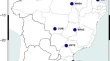
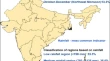
Time-series analysis of MODIS (LST and NDVI) and TRMM rainfall for drought assessment over India P. ThanabalanR. VidhyaR. Manonmani Review 25 April 2023 Pages: 383 - 405
Combined adjustment of GNSS observation results and slit meter measurements for the displacement detection at the Dniester HPP dam Kornyliy TretyakOleksandr ZayatsOleksandr Hrabovyi Original Paper 05 April 2023 Pages: 441 - 453
Closed-form solution to point- and plane-based co-registration of terrestrial LiDAR point clouds Elizeu Martins de Oliveira Jr.Daniel Rodrigues dos Santos Original Paper 01 April 2023 Pages: 421 - 439
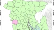
Use of time series Sentinel-1 and Sentinel-2 image for rice crop inventory in parts of Bangladesh Md. Abdullah AzizDipanwita HaldarPrakash Chauhan Original Paper 30 March 2023 Pages: 407 - 420
A GIS-based landslide susceptibility assessment and mapping around the Aba Libanos area, Northwestern Ethiopia Dawit AsmareChalachew TesfaMulusew Minuyelet Zewdie Original Paper 20 March 2023 Pages: 265 - 280
Modeling spatio temporal pattern of urban land use and land cover change by using geospatial technology: a case of Shambu Town, Horo Guduru Wallaga, Ethiopia Lachisa Busha HinkosaMisgana Lamessa DinsaMitiku Badasa Moisa Original Paper 18 March 2023 Pages: 249 - 264
Semi-automatic extraction of land degradation processes using multi sensor data by applying object based classification technique Sudhanshu RaghubanshiRitesh AgrawalD. Ram Rajak Original Paper 18 March 2023 Pages: 239 - 248
The green belt of Baqubah city between reality and ambition Thikra Adel MahmoudSuha Salem Ali Original Paper 14 March 2023 Pages: 29 - 33
Object-based classification of hyperspectral images based on weighted genetic algorithm and deep learning model Davood AkbariVahid Akbari Original Paper 27 February 2023 Pages: 227 - 238
Integrating random forest and synthetic aperture radar improves the estimation and monitoring of woody cover in indigenous forests of South Africa Mcebisi QabaqabaLaven NaidooMoses Azong Cho Original Paper Open access 21 February 2023 Pages: 209 - 225
The European GeoMetre project: developing enhanced large-scale dimensional metrology for geodesy Florian PollingerSergio BaselgaMariusz Wiśniewski Original Paper Open access 20 February 2023 Pages: 371 - 381
Detection of hydrothermal alteration and structural characteristics of Miocene volcanic rocks using remote sensing in the M’sirda region (northwestern Algeria) Khadidja MoussaouiHanafi BenaliBouchra Labdaoui Original Paper 17 February 2023 Pages: 189 - 207
Geomatics-based approach for highway route selection Yasmeen Mohammed SameerAdil Nuhair AbedKhamis Naba Sayl Original Paper 16 February 2023 Pages: 161 - 176
Design, establishment, analysis, and quality control of a high-precision reference frame in Cortes de Pallás (Spain) Luis García-AsenjoLaura MartínezRaquel Luján Original Paper Open access 15 February 2023 Pages: 359 - 370
An effective indoor positioning system by modified linearized least square approach using UWB technology Al-NussairiAhmed Kateb JumaahWahidah HashimA. K. Alami Original Paper 13 February 2023 Pages: 17 - 28
Determination of WGS84 to Adindan datum transformation parameters and its effect for geospatial applications: a case of Addis Ababa City, Ethiopia Melese WondatirGetachew Tesfaye Original Paper 10 February 2023 Pages: 141 - 160
Automated damage detection for port structures using machine learning algorithms in heightfields Frederic HakePaula LippmannIngo Neumann Original Paper Open access 08 February 2023 Pages: 349 - 357
A GIS-based approach for accident hotspots mapping in mountain roads using seasonal and geometric indicators Mehdi AzariAli PaydarVahid Gara Hasanlou Original Paper 19 January 2023 Pages: 127 - 139
Using the integrated application of computational intelligence for landslide susceptibility modeling in East Azerbaijan Province, Iran Solmaz AbdollahizadMohammad Ali BalafarKarim Samadzamini Original Paper 16 January 2023 Pages: 109 - 125
Soil moisture modeling over agricultural fields using C-band synthetic aperture radar and modified Dubois model Manoj Kumar MundaBikash Ranjan Parida Original Paper 14 January 2023 Pages: 97 - 108
A novel fuzzy M-transform technique for sustainable ground water level prediction Mohammed Ahmed MustafaShaymaa Maki KadhamMarwa T. Ahmed Original Paper 14 January 2023 Pages: 9 - 15
Operator-software impact in local tie networks Michael LöslerCornelia EschelbachJean-Pierre Wallerand Original Paper Open access 11 January 2023 Pages: 77 - 95
4D approach for urban tunnelling in a BIM environment Marco TraniSilvia LongoMonica Conti Original Paper 10 January 2023 Pages: 337 - 347
Adaptive spatial discretization using reinforcement learning Jemil Avers ButtAndreas Wieser Original Paper Open access 09 January 2023 Pages: 327 - 336
Ecosystem extent mapping by integrating Landsat 8, PALSAR-2, and GEDI lidar Tenaw GeremewWorku ZewdiePetri Pellikka Original Paper 23 December 2022 Pages: 61 - 76
Assessment of the accuracy of low-cost multi-GNSS receivers in monitoring dynamic response of structures Chenyu XuePanos PsimoulisXiaolin Meng Original Paper Open access 22 December 2022 Pages: 315 - 326
IoT and artificial intelligence–based fuzzy-integral N-transform for sustainable groundwater management Shaymaa Maki KadhamMohammed Ahmed MustafaSathishkumar Karupusamy Original Paper 22 December 2022 Pages: 1 - 8
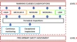
A review of agricultural drought assessment with remote sensing data: methods, issues, challenges and opportunities Archana MullapudiAmol D. VibhuteChandrashekhar H. Patil Review 22 December 2022 Pages: 1 - 13
Using forest fire experts’ opinions and GIS/remote sensing techniques in locating forest fire lookout towers Tayebe AmiriAbbas Banj ShafieiHadi Beygi Heidarlou Original Paper 10 December 2022 Pages: 45 - 59
Satellite remote sensing and GIS-based multi-criteria analysis for assessing the groundwater recharge potential zones in the Regueb basin (central Tunisia) Eya HassiniSonia HassiniYounes Hamed Original Paper 05 December 2022 Pages: 29 - 43
A GIS-based model for automated land suitability assessment for main crops in north-western desert of Egypt (case study: south of Al-Dabaa Corridor) Adel ShalabyHossam KhedrEngy Hassan Original Paper 30 November 2022 Pages: 15 - 28
A multisensor satellite image classification for the detection of mangrove forests in Qeshm Island (Southern Iran) Sadra KarimzadehKhalil Valizadeh KamranMostafa Mahdavifard Original Paper 23 November 2022 Pages: 177 - 188
Assessment of land use–land cover changes using GIS, remote sensing, and CA–Markov model: a case study of Algiers, Algeria Madani HindSetti M’hammedNemer Zoubida Original Paper 02 November 2022 Pages: 811 - 825
Quality of the deflection of the vertical obtained from global geopotential models in horizontal geodetic positioning Rovane Marcos de FrançaIvandro KleinLuis Augusto Koenig Veiga Original Paper 02 November 2022 Pages: 795 - 810
An approach for tree volume estimation using RANSAC and RHT algorithms from TLS dataset Arunima SinghS. K. P. KushwahaHitendra Padalia Original Paper 15 October 2022 Pages: 785 - 794
Correction: Positional accuracy assessment of historical Google Earth imagery in Lagos State, Nigeria Peter C. NwiloChukwuma J. OkolieImeime I. Uyo Correction 14 October 2022 Pages: 827 - 827
Assessment of a dual-frequency multi-GNSS smartphone for surveying applications Guenther RetscherTill Weigert Original Paper Open access 13 October 2022 Pages: 765 - 784
Correction: Cadastral resurvey and integration of geospatial technique using high-resolution satellite image (HRSI): a case study in Indian district Hemant DansenaAmit Prakash MultaniyaM. K. Beg Correction 06 October 2022 Pages: 625 - 625
Ultra-resolution unmanned aerial vehicle (UAV) and digital surface model (DSM) data-based automatic extraction of urban features using object-based image analysis approach in Gurugram, Haryana Nitin ChauhanRitesh KumarKushal Giri Original Paper 01 October 2022 Pages: 751 - 764
An application of geospatial-based multi-criteria decision-making technique to identify landslide susceptibility zones in the Ragnu Khola River Basin of Darjeeling Himalayan region, India Dipesh RoySatyajit DasRajib Mitra Original Paper 26 September 2022 Pages: 731 - 749
Bathymetry from satellite images: a proposal for adapting the band ratio approach to IKONOS data Francesco Giuseppe FigliomeniClaudio Parente Original Paper Open access 17 September 2022 Pages: 565 - 581
Insights into the morphometric characteristics of the Himalayan River using remote sensing and GIS techniques: a case study of Saryu basin, Uttarakhand, India Parvaiz Ahmad GanieRavindra PostiPramod Kumar Pandey Original Paper 15 September 2022 Pages: 707 - 730
Digital mapping and predicting the urban growth: integrating scenarios into cellular automata—Markov chain modeling Oznur IsinkaralarCigdem VarolDilara Yilmaz Original Paper 02 September 2022 Pages: 695 - 705
GNSS-SDR pseudorange quality and single point positioning performance assessment Umberto RobustelliMatteo CutugnoGiovanni Pugliano Original Paper Open access 26 August 2022 Pages: 583 - 594
Combination of close-range and aerial photogrammetry with terrestrial laser scanning to answer microbiological and climatological questions in connection with lava caves Michael KögelAndreas PflitschSimon Regler Original Paper Open access 25 August 2022 Pages: 679 - 694