Automatic Feature Extraction Module for Change Detection in Al Ain, UAE: Analysis by Means of Multi-temporal Remote Sensing Data Samy Ismail ElmahdyMohamed Mostafa Mohamed Research Article 30 July 2015 Pages: 1 - 10
A Method to Determine Appropriate Spatial Resolution for Hard Image Classification Huasheng SunJiaqi WuXinchao Xu Research Article 10 October 2015 Pages: 11 - 19
Semi Automatic Road Extraction by Fusion of High Resolution Optical and Radar Images Elahe KhesaliMohammad Javad Valadan ZoejMaryam Dehghani Research Article 21 October 2015 Pages: 21 - 29
Estimation of Above Ground Biomass for Central Indian Deciduous Forests Using ALOS PALSAR L-Band Data Kiran Chand ThumatyRakesh FararodaV. K. Dadhwal Research Article 28 July 2015 Pages: 31 - 39
Assessing Performance of Tomo-SAR and Backscattering Coefficient for Hemi-Boreal Forest Aboveground Biomass Estimation Wenmei LiErxue ChenChang Jiang Research Article 17 October 2015 Pages: 41 - 48
Habitat Suitability Assessment of Ardeotis nigriceps (Vigors) in Great Indian Bustard Sanctuary, Maharashtra (India) Using Remote Sensing and GIS A. O. VargheseV. B. SawarkarA. K. Joshi Research Article 06 November 2015 Pages: 49 - 57
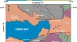
Implementing a Spatial Model to Derive Potential Fishing Zones in the Northern Bay of Bengal Lying Adjacent to West Bengal Coast, India Sandip GiriSudip MannaSugata Hazra Research Article 10 October 2015 Pages: 59 - 66
Assessment of Kalpana-1 Rainfall Product over Indian Meteorological Sub-Divisions During the Summer Monsoon Season M. T. BushairSatya PrakashR. M. Gairola Research Article 07 August 2015 Pages: 67 - 76
Retrieval of CDOM and DOC Using In Situ Hyperspectral Data: A Case Study for Potable Waters in Northeast China Tiantian ShaoKaishan SongBai Zhang Research Article 31 July 2015 Pages: 77 - 89
Integrated Remote Sensing and Structural Analysis Studies of Tayyib Al-Ism Area, Northwestern Arabian Shield, Saudi Arabia Osama M. K. KassemHabes A. GhrefatEslam Elawadi Research Article 31 July 2015 Pages: 91 - 99
Estimating the Numbers and the Areas of Collapsed Buildings by Combining VHR Images, Statistics and Survey Data: a Case Study of the Lushan Earthquake in China Juan NieShihong DuWei Zhang Research Article 08 October 2015 Pages: 101 - 110
Area Delineation and Spatial-Temporal Dynamics of Urban Heat Island in Lanzhou City, China Using Remote Sensing Imagery Jinghu Pan Research Article 19 October 2015 Pages: 111 - 127
Practical Application of 3D Visualization Using Geotechnical Database: A Case Study Karsiyaka (Izmir) Settlement Area (Turkey) Sevnur YeniceliMehmet Ozcelik SHORT NOTE 17 October 2015 Pages: 129 - 134
Estimation of Partial Pressure of Carbon Dioxide and Air-Sea Fluxes in Hooghly Estuary Based on In Situ and Satellite Observations P. C. PadhyR. K. NayakC.B. S. Dutt Short Note 17 October 2015 Pages: 135 - 143