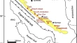
Modeling and risk assessment of landslides using fuzzy logic. Application on the slopes of the Algerian Tell (Algeria) Mohamed Said Guettouche Original Paper 06 July 2012 Pages: 3163 - 3173
A mineralogical and geochemical study of polymict eucrite discovered in Sahara of southwest Algeria Abdelmadjid SeddikiBertrand MoineNacera Remaci Original Paper 12 July 2012 Pages: 3175 - 3184
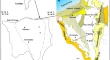
Integrated potential field study on the subsurface structural characterization of the area North Bahariya Oasis, Western Desert, Egypt S. T. ElkhodaryM. A. S. Youssef Original Paper 23 May 2012 Pages: 3185 - 3200
The role of geophysical and seismological data in evaluating the subsurface structures and tectonic trends of Nile Delta, Egypt Salah Saleh Original Paper 09 June 2012 Pages: 3201 - 3216
Application of remotely sensed imagery to watershed analysis a case study of Lake Karoun, Egypt Noha Donia Original Paper 19 July 2012 Pages: 3217 - 3228
Natural radioactivity in basement rocks and stream sediments, Sharm El Sheikh Area, South Sinai, Egypt: radiometric levels and their significant contributions M. Th. S. HeikalB. T. El-DosukyM. I. Sherif Original Paper 11 July 2012 Pages: 3229 - 3239
Monitoring of Dead Sea water surface variation using multi-temporal satellite data and GIS Samih Al RawashdehRami RuzouqAbu Rumman Ghayda Original Paper 27 July 2012 Pages: 3241 - 3248
Hyperspectral satellite data (Hyperion) preprocessing—a case study on banded magnetite quartzite in Godumalai Hill, Salem, Tamil Nadu, India B. Poovalinga GaneshS. AravindanA. Thirunavukkarasu Original Paper 14 June 2012 Pages: 3249 - 3256
Hydrochemical characteristics of groundwater in the plains of Phalgu River in Gaya, Bihar, India Rajesh Kumar RanjanAL. RamanathanAlok Kumar Original Paper 01 June 2012 Pages: 3257 - 3267
Deep-sea foraminifera in a short core from the Bay of Bengal: ecological comparisons with the South China and Sulu Seas N. Rajeshwara RaoP. KamatchiS. Ramesh Original Paper 06 June 2012 Pages: 3269 - 3280
Geochemistry of the late phanerozoic mafic dykes from the Moyar shear zone, South India, and its implications on the spatial extent of Deccan Large Igneous Province P. PratheeshV. PrasannakumarK. R. Praveen Original Paper 30 June 2012 Pages: 3281 - 3291
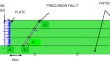
Numerical simulation of fault reactivation phenomenon Abhishek JainA. K. VermaT. N. Singh Original Paper 03 July 2012 Pages: 3293 - 3302
Palynofacies, palaeoenvironment, and source rocks evaluation of Ratawi Formation, Southern Iraq Ryadh Younis Al-ObaidiThamer Khazal Al-AmeriAmer Jassim Al-Khafaji Original Paper 04 July 2012 Pages: 3303 - 3312
The potential of hydrocarbons generation in the Chia Gara Formation at Amadia area, north of Iraq Sahar Y. Jasim Original Paper 04 July 2012 Pages: 3313 - 3318
Efficiency of standardized image processing in the fragmentation prediction in the case of Sungun open-pit mine Mostafa BadroddinEzzeddin BakhtavarBahram Rezaei Original Paper 14 April 2012 Pages: 3319 - 3329
Mapping of the soil texture using geostatistical method (a case study of the Shahrekord plain, central Iran) Yaser SafariIsa Esfandiarpour BoroujeniMohsen Bagheri Bodaghabadi Original Paper 23 May 2012 Pages: 3331 - 3339
Investigation of NDVI in relation to the growth phases of beech leaves in forest Seyed Armin HashemiMir Mozaffar Fallah Chai Original Paper 26 May 2012 Pages: 3341 - 3347
Evaluation of sediment yield and soil loss by the MPSIAC model using GIS at Golestan watershed, northeast of Iran Ali BagherzadehMohammad Reza Mansouri Daneshvar Original Paper 24 April 2012 Pages: 3349 - 3362
An analysis of vegetation indices in relation to tree species diversity using by satellite data in the northern forests of Iran Seyed Armin HashemiMir Mozaffar Fallah ChaiShohreh Bayat Original Paper 11 May 2012 Pages: 3363 - 3369
Capability of ETM+ in estimates standing stock in beech stands of mountain forest Seyed Armin HashemiMir Mozaffar FallahchaiFarahzad Jahan Bakhsh Original Paper 08 May 2012 Pages: 3371 - 3376
Mapping of landslide hazard zonation using GIS at Golestan watershed, northeast of Iran Ali BagherzadehMohammad Reza Mansouri Daneshvar Original Paper 05 May 2012 Pages: 3377 - 3388
Characterization of parameters of sorption isotherm models of cadmium in selected semi-arid region agricultural cambisols and calcisols Habib KhodaverdilooAbbas SamadiFengxiang Han Original Paper 10 May 2012 Pages: 3389 - 3395
Cluster and R-mode factor analyses on soil geochemical data of Masjed-Daghi exploration area, northwestern Iran Afshin AkbarpourNejat GholamiFarhad Mohhamad Torab Original Paper 03 June 2012 Pages: 3397 - 3408
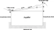
Determination of optimum relaxation coefficient using finite difference method for groundwater flow Farzin SalmasiHazi Mohammad Azamathulla Original Paper 17 June 2012 Pages: 3409 - 3415
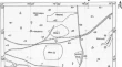
Earth dam site selection using the analytic hierarchy process (AHP): a case study in the west of Iran Minatour YasserKhazaei JahangirAtaei Mohmmad Original Paper 26 June 2012 Pages: 3417 - 3426
Contribution of multivariate statistical techniques in the hydrochemical evaluation of groundwater from the Ouargla phreatic aquifer in Algeria Ahcène SemarHakim SaibiAbderrahmane Medjerab Original Paper 08 July 2012 Pages: 3427 - 3436
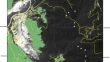
Seismicity and seismotectonics of the Gulf of Aqaba region Zuhair H. El-Isa Original Paper 08 June 2012 Pages: 3437 - 3449
Major ion chemistry and identification of hydrogeochemical processes controlling groundwater in and around Neyveli Lignite Mines, Tamil Nadu, South India S. ChidambaramP. AnandhanM. Vasanthavigar Original Paper 11 May 2012 Pages: 3451 - 3467
Suspended sediment load prediction of river systems: GEP approach H. Md. AzamathullaYong Chong CuanChun Kiat Chang Original Paper 26 June 2012 Pages: 3469 - 3480
Deterministic and probabilistic seismic hazard analysis for Gwadar City, Pakistan Shafiq Ur RehmanMuhammad KhalidAbd El-aziz Khairy Abd El-Aal Original Paper 02 August 2012 Pages: 3481 - 3492
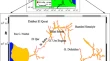
Imaging soil moisture using GPR tomography and reflection field experiments Mohamed G. El-BehirySherif M. Hanafy Original Paper 15 May 2012 Pages: 3493 - 3503
On the application of GPR for locating underground utilities in urban areas Mohamed A. RashedMansour A. Al-Garni Original Paper 10 May 2012 Pages: 3505 - 3511
Utilities of Landsat 7 data and selective image processing in characterization of radioactivity zones of Wadi Baba–Wadi Shalal Area, Westcentral Sinai, Egypt Adel Zein Bishta Original Paper 11 October 2012 Pages: 3513 - 3526
Tracing subsurface oil pollution leakage using 2D electrical resistivity tomography Mohamed MetwalyMohamed Ahmed KhalilAbeer El-Kenawy Original Paper 30 May 2012 Pages: 3527 - 3533
Effect of temperature, pressure, salinity, and surfactant concentration on IFT for surfactant flooding optimization Wimpy KarnandaM. S. BenzagoutaM. M. Amro Original Paper 10 June 2012 Pages: 3535 - 3544
Geochemistry and quality assessment of groundwater using graphical and multivariate statistical methods. A case study: Grombalia phreatic aquifer (Northeastern Tunisia) Besma Tlili-ZrelliFadoua hamzaoui-AzazaRachida Bouhlila Original Paper 27 July 2012 Pages: 3545 - 3561
Flash flood inundation map preparation for wadis in arid regions Zekai ŞenHussam A. KhiyamiHashim M. Al-Hawsawy Original Paper 12 July 2012 Pages: 3563 - 3572
Monitoring the tectonic plate movements in Turkey based on the national continuous GNSS network Turgut UzelKamil ErenHaluk Yilmaz Original Paper 29 July 2012 Pages: 3573 - 3580
Calcareous nannofossils biostratigraphy of the Late Campanian–Early Maastrichtian Age, Block 16, Jiza’-Qamar Basin, Eastern Yemen Khaled A. Al-WosabiAbdulwahab S. Alaug Original Paper 21 August 2012 Pages: 3581 - 3594
Comment on ‘Geodynamic evolution of Jbel Cheid (Northern Tunisian Atlas) from geophysical and geological data’ by R. Benassi (2011) Mohamed-Montassar Ben SlamaMohamed GhanmiFouad Zargouni Comment 31 July 2012 Pages: 3595 - 3600