
Abstract
Besides representation of their place names in public space (in the linguistic landscape) on town signs, road signs, public buildings, etc., finding their names also on topographic maps, notably official topographic maps, is very important for autochthonous linguistic minorities residing in a place already for many generations. They regard this as recognizing their presence and their share in the place. It also means supporting their emotional ties to the place and is, thus, also in the interest of the majority since it strengthens the minority’s loyalty to the majority and their common political entity. Based on Ferjan Ormeling’s seminal work (Ormeling in Minority Toponyms on Maps. The Rendering of Linguistic Minority Toponyms on Topographic Maps of Western Europe (= Utrechtse geografische studies, 30). Utrecht, 1983), later literature and the author’s (together with Přemysl Mácha et al.) recent comparative study of southern Carinthia (Austria) and the Těšín/Cieszyn region (Czechia) (Jordan et al. 2021), the paper endeavors to substantiate that the following are criteria of an adequate minority place-name representation on topographic maps:
-
(a)
Share of minority place names in local use represented on the map
-
(b)
Consistency of minority place-name representation across feature categories
-
(c)
Consistency of minority place-name representation across map scales
-
(d)
Visual representation of minority in relation to majority place names
Zusammenfassung
Neben der Wiedergabe ihrer geographischen Namen im öffentlichen Raum (in der linguistischen Landschaft) auf Ortstafeln, Verkehrshinweistafeln, öffentlichen Gebäuden usw. ist es für altansässige, autochthone sprachliche Minderheiten sehr wichtig, ihre Namen auch auf topographischen Karten, insbesondere amtlichen topographischen Karten, vorzufinden. Sie betrachten dies als Anerkennung ihrer Präsenz, ihrer Teilhabe an einem Lebensraum. Es stärkt auch ihre emotionale Beziehung zu ihm und liegt somit auch im Interesse der Mehrheit, da es die Loyalität der Minderheit zur Mehrheit und zur gemeinsamen politischen Einheit unterstützt. Basierend auf Ferjan Ormelings grundlegendem Buch (Ormeling 1983), späterer Literatur und der jüngsten vergleichenden Studie des Autors (gemeinsam mit Přemysl Mácha et al.) über Südkärnten (Österreich) und die Region Teschen [Těšín/Cieszyn] (Tschechien) (Jordan et al. 2021) versucht der Artikel zu begründen, dass die Angemessenheit der Darstellung von geographischen Namen von Minderheiten auf topographischen Karten nach den folgenden Kriterien bewertet werden kann:
-
(a)
Anteil auf der Karte ausgewiesener an den örtlich verwendeten geographischen Minderheitennamen
-
(b)
Konsistenz der Darstellung geographischer Minderheitennamen über alle Objektkategorien hinweg
-
(c)
Konsistenz der Darstellung geographischer Minderheitennamen über alle Kartenmaßstäbe hinweg
-
(d)
Art der visuellen Darstellung geographischer Minderheitennamen im Verhältnis zu geographischen Namen der Mehrheit
1 Introduction
This article is a contribution at the interface between cartography, geography, linguistics and other disciplines as much as toponomastics, the study of toponyms or place names, is an interdisciplinary field of studies. Place names are elements of every language and have, thus, a long tradition as a research field in linguistics. Before the recent rise of interest of social and cultural geographers in place names, however, place names resorted in the distribution of work between geographers and cartographers rather to the cartographic side due to their important role on maps. This is still reflected by the fact that toponymic commissions and boards are usually hosted by cartographic institutions, notably in the German-speaking sphere, and cartographers play a major role in place-name standardization at all administrative levels up to the United Nations Group of Experts on Geographical Names (UNGEGN). It is, however, also true that toponymic articles in cartographic journals have become a rare exception. If this article succeeds in revitalizing the interest of cartographers in place names and contributes to their wider participation in the activities of the Joint ICA/IGU Commission on Toponymy, this would mean a nice reward to the author.
The article approaches place names, geographical names, or toponyms from a cultural–geographical perspective based on the constructivist approach of social geography as represented by Werlen (1993, 1997, 1999, 2008, 2010, 2018) or Weichhart (2008) and the formative works on the relations of humans to space of Tuan (1974, 1977, 1991), Basso (1988, 1996), Mitchell (2000) and Helleland (2009). More specifically, it assumes the perspective of critical toponomastics, a geographical research current that emerged only in recent decades and looks at place names on the background of and resulting from historical and political conditions (see a.o. Berg and Vuolteenaho 2016). Critical toponomastics is, however, not regarded as an ‘independent’ geographical branch of toponomastics, but as rooted in comprehensive onomastics, the multidisciplinary study of all kinds of proper names, and its body of knowledge.
Why this article is placed in a cartographic journal has its reason in the fact that its topic is place names on maps and that it is part of the pragmatic aspect of cartography, when it raises the question for an adequate minority place-name representation on topographic maps. It is about the range of contents of topographic maps needed in view of their functions and purposes. With this research question the article addresses also first and foremost cartographers in official surveying and mapping institutions and of official topographical maps.
After an introduction into the basic roles of place names in relating humans and geographical space and major functions of place names on maps, the article proceeds to the specific questions of why the public representation of their place names is so important for linguistic minorities and why the adequate reflection of minority place names is not only important for minorities but also for the consistency and user value of topographic maps. It ends by defining criteria for an adequate minority place-name representation on topographic maps with a focus on official maps departing from Ormeling (1983) and based on empirical research conducted by the author (see Jordan et al. 2021).
2 Theoretical Background
Geographical names, toponyms, or place names in the sense of proper names of geographical features, when the latter are understood as features essentially bound to space,Footnote 1 may from a cultural–geographical perspective be regarded as mediators between humans and geographical space, as relating human communities with complex spatial reality reflecting their perception of it. Based on the seminal works of Tuan (1977, 1991), Basso (1988, 1996), Mitchell (2000), Helleland (2009) and earlier contributions by this author (Jordan 2009a, 2012a, 2015, 2016b), it is possible to identify four main roles of place names in linking people and geographical space:
-
Role 1: Place names often reflect the characteristics of space If place names are not commemorative (honoring persons, institutions, or events) or neutral (such as streets named after flowers or birds), but descriptive, they frequently emphasize features of the natural environment (such as location in Waterkant, meaning ‘coast’, Piani di quà meaning ‘the plains here’, Piani di là meaning ‘the plains there’, geomorphology in Table Mountain, Steinernes Meer meaning ‘sea of stones’, presence of water in Feuchte Ebene meaning ‘moist plain’, Suhi dol meaning ‘dry valley’, climatic conditions in Šotovento meaning ‘below the wind’, etc.) or associated political or economic functions (like with Hranice meaning ‘border’, Neumarkt meaning ‘new market’ or Bremerhaven meaning ‘the port of Bremen’). In so doing, such place names are indicative of the needs or desires of those who formalized the name. They, thus, cast not only a glance at the place at the time when it was named, but also at the name-giving community, at their perception of space determined by their cultural disposition. In this way, place names reflect dominant narratives about the place as well as the name-giving community.
-
Role 2: Place names identify the community territory Place names in the status of endonyms, i.e., names accepted and used by the local community, the in-group, are reflective of appropriation in that naming rights belong to those who may be regarded as owners. Exonyms (i.e., names adopted by non-locals), on the other hand, may also sometimes be used to express territorial claims, but this is a misuse and does not correspond to their original function of relating a community with others (see Jordan 2022b).
-
Role 3: Place names support structuring geographical space Orienting in geographical space and subdividing it into features is a basic human attitude and desire very well supported by maps.Footnote 2 But preceding maps already the primary means of human communication, i.e., the spoken language with its words and proper names, fulfilled this function and continues to fulfill it, if it is taken into account that also our modern maps would not make sense, if the locations they indicate could not be addressed and identified by place names or—in the case of ‘mute maps’ their names would not be known by the user.Footnote 3 Departing from the assumption that geographical space is not divided into geographical features ‘by nature’, but by human communities through conceptualization on the background of their cultural disposition, economic, and political interests (see Fig. 1) and our subdivision of geographical space is a mental construct, place names are used to indicate this subdivision. The place name may in some cases be even the only identifier of a geographical feature, for example in historical–cultural regions or landscapes when administrative or distinct natural boundaries are missing. The concept of the geographical feature is nevertheless a social reality, and it is tightly bound up with the consciousness of the local population and with the wider world beyond. Where a part of geographical space lacks a name, this suggests that the place is not defined a geographical feature in its own right, but conceived as forming part of a larger one.
Fig. 1 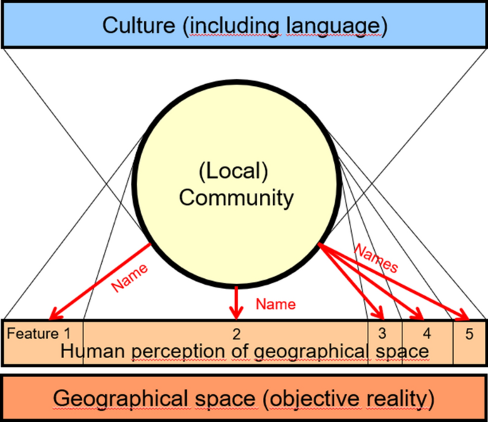
(Author’s own draft)
Factors of the place-naming process
-
Role 4: Place names underpin the emotional relationship between people and place and play a role in identity building When a person has a strong relationship with a particular place, the very mention of its name enables that person to envision all of the characteristics of that place, including associated sights, sounds, smells and people. In other words, the place name invokes what Yi-Fu Tuan refers to as “the feel of a place” (Tuan 1974, 1977, 1991). To some extent, this is also true for places not personally experienced. Their names, too, may convey feelings and emotions according to their images transmitted by education and the media. Rome and Siberia could be mentioned as examples at the positive and negative ends of the range.

When used on maps, place names are not elements of the cartographic symbol system, of the ‘cartographic language’. They are nevertheless not just decorative map elements but exert some important functions (Jordan 2023a):
-
Place names facilitate map use If the name to be found on the map (and accordingly the place marked by this name) is not known to the reader, the place name facilitates map use. Identification of a place indicated by a cartographic symbol becomes much easier, when it is in addition explained by a place name. If a reader not acquainted with the topography shown on the map would try to identify an unknown place without a place name, he/she would have to compare the map in use with other maps or cartographic source materials that do have a place name for the place in question or compare the geographical co-ordinates of the place in question with other sources. Thus, map interpretation would become a complicated and tiresome task.
-
Place names enable searching for places Place names indices are customary components of printed atlases. So are name search functions with interactive electronic atlases. They enable the reader to search for a place on the map via the place name in the index or by inserting a place name into the search function. Without place names, this would not be possible.
-
Place names tell more about the character of a geographical feature While the cartographic symbol marks just a feature category like mountains, passes, lakes, glaciers, rivers, forests, populated places, etc., the place name may tell more about the specifics of a certain geographical feature—not only by a transparent generic element of a composed place name like Coastal Range, where the generic element Range specifies the feature within the wider category of mountains, but also by a transparent specific element such as new/old, great/little, upper/lower, warm/cold, also black/white with running waters, adjectives indicating directions (north/south), adjectives derived from country names (Uherské Hradiště, Uherské meaning ‘Hungarian’), region names (Bohemian Forest [Böhmerwald], Thuringian Forest [Thüringer Wald], Câmpulung, Moldovenesc meaning ‘Moldavian’), ethnonyms (Frankfurt am Main, i.e. ‘Ford of the Frankonians’; Kroatisch Minihof, Kroatisch meaning ‘Croatian’; Valašské Meziříči, Valašské meaning ‘Valachian’), and anthroponyms (Port Elizabeth, Saint Petersburg [Sankt-Peterburg]). Thus, place names hint not only at the language (and herewith culture) of a certain place, but also can tell something about subcategory, function, and history of a feature/place.
3 The Importance of Public Representation of Their Names for Minorities
When we address minorities in this context, we speak of linguistic minorities or non-dominant groups compactly residing in an area for at least four generations having preserved their specific culture including their language. Only autochthonous minorities of this kind had time and cultural power enough to refer names in their own language to geographical features in their surroundings, to create their own ‘namescape’, while younger migrant communities, even more so, when they reside spatially dispersed, tend to adopt the place names they find, not even translating easily to be translated generic name elements (Jordan 2021; Gherghinescu 2014).
Two of the four above-mentioned roles of place names in relating people and space are specifically important for linguistic minorities: the role of identifying the community territory (Role 2), and the role of underpinning the emotional relationship between people and place (Role 4).
In areas that are inhabited by more than one linguistic community, these communities compete for the public, official designation of a geographical feature. With their strive for public recognition of their names, both communities want this place to be identified as theirs, wish to relate their group identities to it, and express that they feel responsible and accountable for this place. Without conflict between them, this is only possible if each of them accepts the claim of the other and feels comfortable with a shared or common identity of the place. A conflict as it has occurred and occurs in many cases (see Horn 2004; Eller et al. 2008; Hren 2022; Jordan 2022a) indicates that such mutual acceptance is not (sufficiently) given, and that the dominant community is not ready to give in or to share (see Figs. 2, 3).

(Photo: Jordan 2008)
In the Val di Resia, in the Italian Autonomous Region Friuli-Venezia Giulia near the Slovenian border, the local majority claims to be and speak Resian, to which the settlement name Poclanaz corresponds, while the name of the local Slovenian minority Tapodklancon is paint-brushed

(Photo: Jordan 2017)
In the Val Canale, in the Italian Autonomous Region Friuli-Venezia Giulia near the Austrian and Slovenian borders, the name of the local Slovenian minority Lužnica on a road sign has been paint-brushed
Dispute about the public rendering of the place name is always an expression of deeper conflict reasons. For the non-dominant community, it is usually more important than for the dominant to see its relationship to the place recognized by a name—right because it is the minority and non-dominant, and because it is not always obvious for the outside world that it is present there. A minority also requires a higher level of self-assurance. Members of a minority face almost daily the challenge to confess identity (Reiterer 2003).
When non-dominant communities strive for the public recognition of their place names, they strive—abstractly formulated—for the symbolic function of marking their territory, for the opportunity of demonstrating their presence, but also for the visual support of their emotional attachment to the place (see Jordan 2004, 2006a, 2009b, 2012b, 2014, 2016a). If a member of a non-dominant community reads the place name in his/her own language and script on a town sign or on a map, a sense of familiarity develops.
Since only communities established in a place for generations have developed own place names for the features in their surroundings, they regard the public representation of their geographical names also as an acknowledgment of their presence for generations and recognition of the fact that their group has contributed to shape culture and cultural landscape.
It is for this very reason also a wise decision on the side of the dominant community to grant the non-dominant group this right: it will satisfy the non-dominant group; it will promote its sense for cooperation and its loyalty.
It is most important that the minority feels that this is ‘their’ name—the endonym in the sense of the name used and accepted by the local community. The name in the minority language should, therefore, strictly observe the orthography of the minority language, with all its diacritics and special characters, also if they are not familiar to majority language speakers (see Fig. 4). An alienated notation adapted to the orthography of the majority language does not satisfy this purpose. If linguistic minorities write their names in a script different from the majority, it is for the same reason also appropriate to use this other script and not to convert it (see Fig. 5).

(Source: Bundesamt für Eich- und Vermessungswesen 2023)
The Austrian Map 1:250,000 practices bilingual (German/Slovene) naming of populated places with officially bilingual names by reflecting the orthography of the Slovene language including all diacritics. Section of southern Carinthia [Kärnten]

(Photo: Jordan 2008)
Bilingual (Romanian/Ukrainian) and biscriptual (Latin/Cyrillic) town sign in the Maramures County [judeţ Maramureş], Romania, based on the Romanian Place-Name Act 2001 (see Jordan 2006b)
Besides representation of their place names in public space (in the linguistic landscape), i.e., on town signs, road (traffic) signs, public buildings, etc. (see Cenoz and Gorter 2006; Jordan and Balode 2021; Mácha et al. 2021), finding their names also on topographic maps, notably official topographic maps, is very important for linguistic minorities. Ferjan Ormeling has hinted on that already in his seminal work “Minority Toponyms on Maps. The Rendering of Linguistic Minority Toponyms on Topographic Maps of Western Europe” (Ormeling 1983). As one of the two project leaders, this article’s author has recently explored this field by a comparative in-depth study of two minority situations, i.e., the case of the Slovenian minority in Carinthia [Kärnten], Austria, and the case of the Těšín/Cieszyn Region, Czechia.
In recognizing the value of all languages and their place names, the United Nations, represented by their Conferences on the Standardization of Geographical Names (UNCSGN), have passed several resolutions supporting the safeguarding, use and public representation of place names in minority and indigenous languages (Resolutions II/36 1972, V/22/ 1987, VIII/1 2002, IX/5 2007, see UNGEGN 2023a). Already the First United Nations Conference on the Standardization of Geographical Names 1967 in Geneva passed Recommendation D—Multilingual Areas: “It is recommended that, in countries in which there exist more than one language, the national authority as appropriate: (a) determine the geographical names in each of the official languages, and other languages as appropriate; (b) give a clear indication of equality or precedence of officially acknowledged names; (c) publish these officially acknowledged names in maps and gazetteers.” (UNGEGN 2023a).
This has been confirmed by the United Nations Educational, Scientific and Cultural Organization (UNESCO) in its Convention for the Safeguarding of the Intangible Cultural Heritage passed in 2003 and entered into force on 20 April 2006. It defines in its Article 2, Paragraph 1, intangible cultural heritage as “the practices, representations, expressions, knowledge, skills—as well as the instruments, objects, artifacts and cultural spaces associated therewith—that communities, groups and, in some cases, individuals recognize as part of their cultural heritage [….]” and regards as its domains “(a) oral traditions and expressions, including language as a vehicle of the intangible cultural heritage; (b) performing arts; (c) social practices, rituals and festive events; (d) knowledge and practices concerning nature and the universe; (e) traditional craftsmanship.” (UNESCO 2023).
In the years following, several symposia on this topic were held and proceedings published: the first in Vienna [Wien], 19–21 May 2008, organized by the United Nations Group of Experts on Geographical Names’ (UNGEGN) Dutch and German Speaking Division (DGSD) (see Jordan et al. 2009); the second in Seoul 7–9 November 2014, organized by the National Geographic Information Institute (NGII) of the Republic of Korea (see Choo 2015); the third in Florence [Firenze], 26–27 March 2015, organized by UNGEGN’s Romano-Hellenic Division (see Cantile and Kerfoot 2016). In parallel and supported by this scientific expertise, UNGEGN elaborated resolutions that were passed by subsequent United Nations Conferences on the Standardization of Geographical Names: Resolution VIII/9 (2002): “Geographical names as cultural heritage”, Resolution IX/4 (2007): “Geographical names as intangible cultural heritage”, Resolution X/3 (2012): “Criteria for establishing and evaluating the nature of geographical names as cultural heritage” (see UNGEGN 2023a).
4 The Importance of Minority Place Names for Topographic Maps
Why is it not only important for linguistic minorities to find their place names on topographic maps, but also—vice versa—for topographic maps to reflect minority place names? Besides the very political reason, mentioned already by Ormeling (1983), that members of minorities are citizens and taxpayers of a country as much as members of the majority population and deserve, therefore, to be treated equally at least by official topographic maps produced also by support of their taxes, three groups of arguments can be mentioned in this context (Jordan 1988): topographic maps reflecting also minority place names
-
(1)
do more for general orientation, their main purpose, when they capture more of spatial reality and do not exclude a certain group of possible contents;
-
(2)
find better access to a potential user group, i.e., a minority;
-
(3)
form a more profound and reliable basis for research in toponomastics, settlement geography, settlement history, and cultural history.
Argument (1) is nicely underpinned by the instructions of the Third Austrian, from 1867 on Austro-Hungarian Military Survey (quoted after Włoskowicz 2023): “(…) eine richtige und correcte Angabe der Benennungen bleibt eines der wesentlichsten Merkmale der Güte und Verläßlichkeit einer Karte, namentlich einer Karte, die zu Kriegszwecken zu dienen hat.” (Instruction für die militärische Landesaufnahme IN1875: 59)Footnote 4 “Namen, welche in einer Gegend weit und allgemein bekannt sind, müssen als Orientirungsmittel [sic!] jedenfalls aufgenommen werden” (Instruction für die militärische Landesaufnahme IN1875: 91)Footnote 5 “Nur jene Namen, welche der Bevölkerung geläufig sind, haben für den Soldaten Wert.” (Instruction für die militärische Landesaufnahme IN1903: 167)Footnote 6 “Bei Ortschaften, Gebieten etc., welche gemischte Bevölkerung haben und mehrere Namen—in verschiedenen Sprachen—führen, ist der allgemein übliche oder der dem größern Bevölkerungsantheile zukommende als Hauptname zu bezeichnen, der andere jedoch auch beizusetzen.” (Instruction für die militärische Landesaufnahme IN1875: 60)Footnote 7 “In gemischtsprachigen Gegenden sind auch die von den verschiedenen Nationalitäten gebrauchten Namen zu erheben.” (Instruction für die militärische Landesaufnahme IN1903: 167)Footnote 8 “Bei gemischtsprachiger Bevölkerung ist der am häufigsten gebrauchte Namen vorauszusetzen; die anderen üblichen Bezeichnungen sind in Klammern beizufügen, jedoch nur dann, wenn sie wesentlich anders lauten und von einen [sic!] bemerkenswerten Theile der Bevölkerung benützt werden.” (Instruction für die militärische Landesaufnahme IN1903: 176)Footnote 9 These instructions were effectuated by the Special Map [Spezialkarte] 1:75,000 that remained the mapwork with the highest sensibility for minority place names in Austrian cartography up to the present day.
While these instructions are formulated for topographic maps with a predominantly military purpose, they are not less true for several civil uses, mainly for hiking and other touristic purposes, or in cases of emergency, since it is frequently so that in bi- or multilingual areas features are locally mainly known by their name in the minority language, because this is in many cases the older, the original name. This refers especially to names for features of the micro-scale like field names, names of forests and farmsteads, creeks and canons—so-called ‘microtoponyms’.
While argument (2) needs no further explanation, argument (3) can be substantiated by sentences of a historical speech given by k.k. Ministerial-Secretär Dr. A. Beck in the first assembly of the Austrian Imperial Royal Geographical Society of 17 February 1857: “….Ferner ist Niemanden in der geehrten Versammlung unbekannt, dass in der neuesten Zeit die Ortsnamen ein specieller Gegenstand historisch-ethnographischer Studien geworden sind, und das Dunkel jener Jahrhunderte, in welche geschriebene Denkmale nicht hinaufreichen, fast nur durch scharfsinnige Deutung der ältesten Ortsnamen bis zu einem gewissen Grade aufgehellt werden kann. Für die Frage, ob die Ureinwohner gewisser Länder Europa’s dem celtischen, germanischen, slavischen oder noch einem andern Volksstamme angehörten, ist die Kenntniss aller topographischen Bezeichnungen von entscheidender Wichtigkeit und die Ortsnamen sind die Kerntruppen, mit welchen die gelehrten Schlachten auf diesem Felde geschlagen werden…” (Beck 1857: 102–103, quoted after Włoskowicz 2023).Footnote 10
This statement of 1857 has not lost in validity (see a.o. Włoskowicz 2019). It eloquently explains why historical topographic maps have exceptional value for cultural-historical research: not the least due to reflecting historical cultural structures—contemporary ethnic and linguistic situations included—by a complete representation of toponymy, majority as well as minority place names. It needs, thus, to be emphasized that a topographic map is—or can be—not only a means of orientation, but also a comprehensive survey of a region’s material and intangible cultural structures with considerable value for later historical research. The immense research value of historical map collections should always be kept in mind when we plan and construct our modern topographic maps.
5 Criteria for an Adequate Minority Place-Name Representation on Topographic Maps
Based on the literature quoted and the arguments presented in Chapters 3 and 4, we will now try to explain why the following were essential criteria for an adequate minority place-name representation on topographical maps:
-
Share of minority place names in local use represented on the map;
-
Consistency of minority place-name representation across feature categories: does a certain mode of minority place-name rendering only affect certain feature categories or all of them?
-
Consistency of minority place-name representation across map scales: do minority names only or predominantly occur in the largest scale or are they—in line with generalization—also reflected in derived scales?
-
Visual representation of minority in relation to majority place names: are both represented in the same font size and type? Are they separated by a slash or is the minority name set in brackets?
5.1 Share of Minority Place Names in Local Use Represented on the Map
In most cases, geographical features in a minority area bear in addition to the name in the majority language also the name in the minority language, even if this is not a monolingual area populated only by the minority, but a bi- or multilingual area, where two or more linguistic groups co-exist. A minority residing in an area for many generations and having preserved its culture and language has usually names for all features in its surroundings, also for a neighboring village not inhabited by the minority, and of course also for natural features, because they are part of their residential area in the wider sense, of their living sphere including recreation and their perceived environment.
On a topographical map, not only official, but also non-official names of the minority could be represented, ideally differentiated from official names by arrangement or font size, e.g., by positioning the two official names in larger letters divided by a slash and the unofficial minority name in smaller letters or/and in brackets. Adaptations of the minority-language orthography to the orthography of the majority language will not count as minority names, since they look alien to the minority, will not be accepted as their endonyms. The same is certainly true, when minority names written in other scripts are converted to the script of the majority language—even if this conversion is exerted not by phonetic transcription but by transliteration, i.e., by literal conversion. A 100% share of minority place names would, thus, mean that all names used and accepted by the local minority (endonyms) for features represented on a topographic map of a certain scale are represented—official as well as unofficial names, names of all feature categories, in addition to the majority place name or exclusively.
Deviations from this ideal occur in practice most frequently by representing only official minority names,Footnote 11 or only minority names of populated places, not of natural features. Very frequently also, the minority-language orthography is adapted to the orthography of the majority language.
5.2 Consistency Across Feature Categories
Topographic maps represent not only populated places, but also natural features of all kinds (water bodies, relief features, glaciers, caves), features of the transportation infrastructure such as road and railway networks as well as various kinds of administrative units with their boundaries. Besides populated places, most likely natural features and administrative units are shown with their names.
As already mentioned, with all probability, the minority population of a certain village, town or city has place names also for natural features in its surroundings, since the living sphere of their inhabitants is not confined to the built-up area but comprises agricultural and recreational areas as well—in fact at least all features in visible distance from the populated place, their daily sphere of perception. A river crossing a town with a minority population, e.g., has certainly also a minority name. The same is true for a mountain that can be seen from the populated place. It would, therefore, correspond to the intrinsic logic of a topographic map to confine bi- or multilingual naming not to populated places, but to extend it to natural features, even if their minority place names do not enjoy the same extent of officiality than those of populated places. Another argument for the bilingual rendering also of natural features is that the purpose of an official topographic map is not only orientation but also documenting the cultural landscape in all its facets. And this would mean that also natural features are denoted by all standardized namesFootnote 12 they have.
Administrative units are a somewhat different case, since their names are by definition administratively defined or official. If their name is by law or administrative decision bi- or multilingual, at least an official topographic map had to show this name. Administrative units are, however, rarely named on the map face, rather on an insert in the map frame or in an accompanying text.
A frequently heard objection against including all feature categories into bi- or multilingual naming is that the names of various feature categories correspond to different levels of officiality or standardization: while names of populated places and administrative units are usually defined by law or decision of official authorities, names of natural features are in some countries ‘only’ standardized by the official mapping and surveying agency verifying their local use and defining their final rendering based on the agency’s instructions and regulations as well as by facultatively consulting experts and expert bodies. This, however, is also true for names in the majority language, since standardization requires in principle different procedures by feature categories: while a populated place or an administrative unit can easily be attributed to a certain jurisdiction or has its own jurisdiction, and decision processes are well defined, this is not as easy with natural features, most specifically with natural features transgressing jurisdictions.
Lack of map space for a bi- or multilingual rendering not only of names of populated places, however, is not a convincing argument, since right names of natural features find much empty map space or can be positioned on the map face rather flexibly using spaces where they do not disturb other map contents. The name of a river, e.g., can easily be placed where it crosses a wider unsettled area, where its visibility is anyway better than within crowded settlement areas; the name of a mountain peak is usually not competing with any other map content.
Looking into practice on topographic maps, minority names are not always added to all feature categories in the minority area. Very frequently only populated places are named bi- or multilingually, not natural features.
5.3 Consistency Across Map Scales
It frequently occurs that bi- or multilingual naming is confined to the largest scale of an official topographic map series, because “this is the scale for the highest density of information”, “minority place names are just of local interest”, “there is not space enough for bi- or multilingual naming in smaller scales”.
It would, however, correspond to all the arguments mentioned in the Chapters 3 and 4 as well as to the very justified demand that once a feature has two (or more) names, it has to get known with all its names in all kinds of communication and in all contexts, to represent minority names throughout all map scales—of course respecting the general rules of generalization, i.e., in line with the reduction of map contents.
From the opposite angle, it has to be stated that except on thematic maps or topographic maps with a special purpose (e.g., highlighting minority situations), there is no reason to maintain small features also in smaller scales just because they have minority place names.
5.4 Visual Representation of Minority in Relation to Majority Names
The second position of the minority name after or below the name in the language of the nation-wide majority is justified, because a certain sequence is unavoidable, the nation-wide official language deserves priority over regional or local languages, and varying sequence according to local majorities may be a confusing factor for map reading. Also a different font type for majority and minority name may be appropriate to clearly indicate the attribution of names to their languages, although this would already be done by consequently observing name sequence.
There is, however, no reason why the two or more official and/or standardized names of a feature are not to appear in the same font size, ideally divided by a slash (see Fig. 6). Smaller letters for the minority name(s) or the minority name(s) in brackets are no adequate solutions if minority names are to be respected as ranking equal to majority names.

(Source: Bundesamt für Eich- und Vermessungswesen 2023)
The Austrian Map 1:250,000 represents populated places in Austria with a minority share of at least 17.5% in the overall population (plus some additional populated places due to communal decision, see Piko-Rustia 2021) and, thus, denoted by official minority names named bilingually (German/Slovene) in the same font type and size divided by a slash. This practice is to be extended to the map scale 1:50,000. Section of southeastern Carinthia [Kärnten] at the border (violet band) with Slovenia
6 Conclusion
In democratic countries with otherwise well-established minority rights, it is just consequent to extend a proportional representation of autochthonous linguistic minorities also to topographic maps. This is in the interest of minorities as well as of the communicative value of topographic maps when their objectives are understood as treating and serving all citizens of a country equally, as functioning as means of orientation as well as documents of the cultural landscape. The article provided guidelines how to achieve these goals as well as criteria how to evaluate the quality of existing topographic maps in this respect. In a next step, a team of authors will examine (among other fields of place-name regulations and practice) to which extent topographic maps of European countries meet these criteria (see Jordan 2023b).
Notes
“Bound to space” means in this context that relation to space is essential for the feature to be called ‘geographical’, but that the feature needs not necessarily to be stationary. Also moving features like winds, sea currents, meteorological highs or lows can be regarded as geographical features, since their identity is bound to space. The Gulf Stream or the hurricane Catharina acquire(d) their identity from occurring in a certain section of space. They are/were therefore geographical features, while a ship’s identity (like the identity of the ship “Queen Elisabeth”) does not depend on its location but remains the same wherever it cruises. Queen Elisabeth is therefore not a geographical names, toponym or place name.
The author owes this essential statement to Georg Gartner and his keynote “Revisiting the relevance of cartography” presented to the International Cartographic Conference in Cape Town, 13–18 August 2023.
A place name is here conceived in the widest sense including also just letters (A, B) or numbers.
“(…) providing right and correct names remains one of the essential features defining quality and reliability of a map, namely a map that is meant to serve military purposes.” (Instruction für die militärische Landesaufnahme IN1875: 59, translation by Wojciech Włoskowicz).
“Names that are commonly known in a given area must be in any case fixed down as a tool of orientation.” (Instruction für die militärische Landesaufnahme IN1875: 91, translation by Wojciech Włoskowicz).
“Only the names commonly familiar to the people are of value for a soldier.” (Instruction für die militärische Landesaufnahme IN1903: 167, translation by Wojciech Włoskowicz).
“In the case of localities, areas etc. that are inhabited by a mixed population and bear multiple names in various languages it is the commonly used name or the one that is used by the biggest part of population that has to be marked as the main name while other names are to be listed next to it as well.” (Instruction für die militärische Landesaufnahme IN1875: 60, translation by Wojciech Włoskowicz).
“In linguistically mixed areas names used by various nationalities are to be collected as well.” (Instruction für die militärische Landesaufnahme IN1903: 167, translation by Wojciech Włoskowicz).
“In the case of linguistically mixed population it is the most often used name that is to be placed in the first position; other common names are to be added in brackets only if they sound substantially different and are used by a considerable part of population.” (Instruction für die militärische Landesaufnahme IN1903: 176, translation by Wojciech Włoskowicz).
“… Moreover, it is surely well known to everybody in this respectable assembly that names of localities have recently become a special object of historical and ethnographic studies and that the darkness of the centuries that cannot be reached through written documents may be, at least to a certain extent, illuminated with astute interpretation of the oldest place names. As far as the question is concerned whether the native inhabitants of specific European countries belonged to the Celtic, Germanic, Slavic or any other tribes, the knowledge of all topographic names is of crucial importance and names of localities constitute a kind of elite troops fighting scholarly battles in this field…” (Beck 1857: 102–103; translation by Wojciech Włoskowicz).
There may exist several levels of officiality of place names, i.e., place names defined by law, place names defined by legally authorized institutions, place names defined by administrative decisions on sub-national levels (e.g., municipality), place names verified as in local use and adopted by legally authorized institutions (like national mapping agencies, national standardization boards).
The UNGEGN Glossary of Terms for the Standardization of Geographical Names defines “standardization of geographical names” as “The prescription by a names authority of one or more particular names, together with their precise written form, for application to a specific geographical feature, as well as the conditions for their use. In a wider sense, standardization of toponyms.“ (UNGEGN 2023b: 24).
References
Basso KH (1988) Speaking with names: language and landscape among the Western Apache. Cult Anthropol 3(2):99–130
Basso KH (1996) Wisdom sits in places. Landscape and Language among the Western Apache. University of New Mexico Press, Albuquerque
Beck A (1857) Ueber die Nothwendigkeit eines topographischen Lexikons der österr. Monarchie. In: Mittheilungen der Kaiserlich-Königlichen Geographischen Gesellschaft 1. pp 100–105
Berg LD, Vuolteenaho J (2016) Critical toponymies. The contested politics of place naming. Routledge, London
Bundesamt für Eich- und Vermessungswesen (BEV) (ed.) (2023) Austrian Map. http://www.austrianmap.at. Accessed 27 July 2023
Cantile A, Kerfoot H (eds) (2016P) Place names as intangible cultural heritage. IGMI, Firenze
Cenoz J, Gorter D (2006) Linguistic landscape and minority languages. Int J Multiling 3(1):67–80
Choo S (ed.) (2015) Geographical names as cultural heritage: proceedings of the international symposium on Toponymy, Seoul 7–9 November, 2014. Kyung Hee University Press, Seoul
Eller N, Hackl St, Ľupták M (eds.) (2008) Namen und ihr Konfliktpotential im europäischen Kontext. Regensburger Symposium, 11.-13. April 2007 (= Regensburger Studien zur Namenforschung, 4). Edition Vulpes, Regensburg
Gherghinescu G-R (2014) Integration und Image rumänischer Migranten in Wien. MA thesis, University of Vienna
Helleland B (2009) Place names as means of landscape identity. In: Jordan P, Bergmann H, Cheetham C, Hausner I. (eds.). Geographical names as a part of the cultural heritage (= Wiener Schriften zur Geographie und Kartographie, 18), pp. 25–31. Institut für Geographie und Regionalforschung der Universität Wien, Kartographie und Geoinformation, Wien
Horn J (2004) Ortsnamenkonflikte. Lösungswege für mehrsprachige Gebiete. Asgrad. Sankt Augustin
Hren K (2022) Kärntner Ortstafelsturm—50 Jahre danach sind die meisten „g’scheiter“. In: Anderwald K, Hren K, Stainer-Hämmerle K (eds) Kärntner Jahrbuch für Politik 2022/Koroški politični zbornik 2022. Hermagoras Verlag/Mohorjeva založba, Klagenfurt am Wörthersee, pp 151–160
Instruction für die militärische Landesaufnahme (Militärmappirung) II. Theil (IN1875) (1875) Verlag des k.k. militär-geografischen Instituts, Wien
Instruction für die militärische Landesaufnahme. II. Technischer Theil (IN1903) (1903) 2nd edn. Verlag des k. u. k. militär-geographischen Institutes, Wien
Jordan P (1988) Möglichkeiten einer stärkeren Berücksichtigung slowenischer Ortsnamen in den heutigen amtlichen topographischen Karten Österreichs (= Österreichische Akademie der Wissenschaften, Institut für Kartographie, Berichte und Informationen, 6). Österreichische Akademie der Wissenschaften, Institut für Kartographie, Wien
Jordan P (2004) Ortsnamen als Kulturgut—Die symbolische Wirkung von Ortsnamen auf Ortstafeln und in Karten. In: Pandel M et al (eds) Ortstafelkonflikt in Kärnten—Krise oder Chance? (= Ethnos, 64). Braumüller, Wien, pp 216–229
Jordan P (2006a) Zur amtlichen Verwendung von Minderheitennamen. Ein Vergleich von Situationen in Mitteleuropa. In: Kriz K, Cartwright W, Pucher A, Kinberger M (eds.). Cartography as a Communication Medium (= Wiener Schriften zur Geographie und Kartographie, 17). Institut für Geographie und Regionalforschung der Universität Wien, Kartographie und Geoinformation, Wien, pp 98–106
Jordan P (2006b) Das rumänische Ortsnamengesetz und seine Umsetzung im Vergleich mit Situationen in Österreich. Rev Hist Geogr Toponomast 1(1):7–20
Jordan P (2009a) Place names as ingredients of space-related identity. In: Jordan P, Bergmann H, Cheetham C, Hausner I (eds) Geographical Names as a Part of the Cultural Heritage (= Wiener Schriften zur Geographie und Kartographie, 18). Institut für Geographie und Regionalforschung der Universität Wien, Kartographie und Geoinformation, Wien, pp 33–39
Jordan P (2009b) Use of place names on road signposts. Examples of practice in Central Europe. In: Ahrens W, Embleton S, Lapierre A (eds) Names in multi-lingual, multi-cultural and multi-ethnic contact. Proceedings of the 23rd international congress of onomastic sciences, August 17–22, 2008, (CD-ROM). York University, Toronto, pp 551–565
Jordan P (2012a) Geographische Namen als Ausdruck menschlicher Raumbindung. Mitteilungen Der Österreichischen Geographischen Gesellschaft 154:67–88
Jordan P (2012b) Zur Bedeutung zweisprachiger geographischer Namen für die kulturelle Identität. In: Hren K, Pandel M (eds) Ein Jahr danach. Die Ortstafelregelung 2011 und was daraus wurde. Hermagoras/Mohorjeva, Klagenfurt/Celovec—Ljubljana/Laibach—Wien/Dunaj, pp 125–146
Jordan P (2014) The meaning of bilingual naming in public space for the cultural identity of linguistic minorities. Rev Hist Geogr Toponomast IX 17–18:21–24
Jordan P (2015) The endonym/exonym divide from a cultural-geographical point of view. In: Löfström J, Schnabel-Le Corre B (eds) Challenges in synchronic toponymy. Narr Francke Attempto Verlag, Tübingen, pp 163–179
Jordan P (2016a) The meaning of bi- or multilingual naming in public space for the cultural identity of linguistic minorities. Nomina Afr J Names Soc South Afr 30(1):27–44
Jordan P (2016b) Place names as an expression of human relations to space. In: Hough C, Izdebska D (eds) ICOS 2014. Names and their environment. Proceedings of the 25th international congress of onomastic sciences, Glasgow, 25–29 August 2014, Volume 1: keynote lectures. Toponomastics 1. University of Glasgow, Glasgow, pp 209–223
Jordan P (2021) “Place names and migration” as a research field. In: Dollimore A, Jordan P (eds) Place names and migration. Proceedings of the symposium in Vienna, 6–8 November 2019. Verlag Dr. Kovač, Hamburg, pp 11–28
Jordan P (2022a) The symbolic power of geographical names as a source of conflict. In: D’Aponte T, Pagnini MP, Terranova G (eds) Visioni geopolitiche di un mondo disordinario (= Geografia economico-politica, 37). Aracne, Roma, pp 93–110
Jordan P (2022b) Breslau oder Wrocław? Das Begriffspaar Endonym/Exonym als Kernthema der Kritischen Toponomastik. Wie politische Haltungen den Gebrauch geographischer Namen bestimmen. Franz Steiner Verlag, Stuttgart
Jordan P (2023a) Functions and principles of geographical names. In: ICA Commission on Atlases (ed) The Atlas Cookbook. Ten ingredients how to edit an atlas, Zurich, pp 61–67
Jordan P (2023b) Minority place-name standardization: a comparison of regulations and approaches in Europe. United Nations Group of Experts on Geographical Names 2023b session New York, 1–5 May 2023, GEGN.2/2023/39. https://unstats.un.org/unsd/ungegn/sessions/3rd_session_2023/documents/GEGN2_2023_39_E.pdf. Accessed 29 July 2023
Jordan P, Balode M (2021) Linguistic Landscape. In: Jordan P, Mácha P et al (eds) Place-name politics in multilingual areas. A comparative study of Southern Carinthia (Austria) and the Těšín/Cieszyn Region (Czechia). Palgrave Macmillan, Cham, pp 313–361
Jordan P, Bergmann H, Cheetham C, Hausner I (eds) (2009) Geographical names as a part of the cultural heritage. Institut für Geographie und Regionalforschung der Universität Wien, Kartographie und Geoinformation, Wien
Jordan P, Mácha P, Balode M, Krtička L, Obrusník U, Pilch P, Sancho Reinoso A (2021) Place-name politics in multilingual areas. A comparative study of Southern Carinthia (Austria) and the Těšín/Cieszyn Region (Czechia). Palgrave Macmillan, Cham
Mácha P, Obrusník U, Krtička L (2021) Research Results. Těšín/Cieszyn Region. Linguistic landscape. In: Jordan P, Mácha P et al (eds) Place-name politics in multilingual areas. A comparative study of Southern Carinthia (Austria) and the Těšín/Cieszyn Region (Czechia). Palgrave Macmillan, Cham, pp 425–447
Mitchell D (2005) Cultural geography. A critical introduction. Blackwell Publishing, Malden
Ormeling FJ (1983) Minority Toponyms on Maps. The Rendering of Linguistic Minority Toponyms on Topographic Maps of Western Europe (= Utrechtse geografische studies, 30). Utrecht
Piko-Rustia M (2021) Utilization of communal autonomy to implement additional bilingual names of populated places and streets in Carinthia. United Nations Group of Experts on Geographical Names 2021 session virtual, 3–7 May 2021, GEGN.2/2021/71. https://unstats.un.org/unsd/ungegn/sessions/2nd_session_2021/documents/2021_71-Carinthia_E.pdf. Accessed 29 July 2023
Reiterer AF (2003) Sprache Ist Auch Heimat. Raum 51:24–26
Tuan Y-F (1974) Topophilia. A study of environmental perception, attitudes, and values. Prentice Hall, New Jersey
Tuan Y-F (1977) Space and place: the perspective of experience. University of Minnesota Press, Minneapolis
Tuan Y-F (1991) Language and the making of place: a narrative-descriptive approach. Ann Assoc Am Geogr LXXXI:684–696
United Nations Educational, Scientific and Cultural Organization (UNESCO) (ed) (2023) Convention for the safeguarding of the intangible cultural heritage. https://ich.unesco.org/en/convention. Accessed 02 Apr 2023
United Nations Group of Experts on Geographical Names (UNGEGN) (ed) (2023a) UNCSGN resolutions 1967–2017. https://unstats.un.org/unsd/ungegn/resolutions/. Accessed 28 July 2023a
United Nations Group of Experts on Geographical Names (UNGEGN) (ed.) (2023b) Glossary of terms for the standardization of geographical names. https://unstats.un.org/unsd/ungegn/pubs/documents/Glossary_of_terms_rev.pdf. Accessed 30 July 2023b
Weichhart P (2008) Entwicklungslinien der Sozialgeographie. Von Hans Bobek bis Benno Werlen. Steiner, Stuttgart
Werlen B (1993) Society, action and space. An alternative human geography. Preface by Anthony Giddens. Routledge, London
Werlen B (1997 [1987]) Gesellschaft, Handlung und Raum Grundlagen handlungstheoretische Sozialgeographie. Steiner, Stuttgart
Werlen B (1999) [1995]) Zur Ontologie von Gesellschaft und Raum. Steiner, Stuttgart
Werlen B (2008 [2000]) Sozialgeographie. Eine Einführung. Haupt/UTB, Bern
Werlen B (2010) Orte der Geographie. Steiner, Stuttgart
Werlen B (2018 [2010]) Konstruktion geographischer Wirklichkeiten. Steiner, Stuttgart
Włoskowicz W (2019) Dissemination and correctness of geographical names. Geographers and cartographers as toponym users and promoters. Mitteilungen Der Österreichischen Geographischen Gesellschaft 161:291–324. https://doi.org/10.1553/moegg161s291
Włoskowicz W (2023) Austrian toponymic policy in the late 18th to early 20th century cartography of Galicia and Bukovina. In: Onoma 58 (In print)
Funding
Open access funding provided by Österreichische Akademie der Wissenschaften.
Author information
Authors and Affiliations
Corresponding author
Additional information
Peter Jordan, Ph.D., Honorary and Associate Professor; ICA Chair, Joint ICA/IGU Commission on Toponymy; ICA Liaison Officer with the United Nations Group of Experts on Geographical Names (UNGEGN); Vice-President, International Council of Onomastic Sciences (ICOS).
Rights and permissions
Open Access This article is licensed under a Creative Commons Attribution 4.0 International License, which permits use, sharing, adaptation, distribution and reproduction in any medium or format, as long as you give appropriate credit to the original author(s) and the source, provide a link to the Creative Commons licence, and indicate if changes were made. The images or other third party material in this article are included in the article's Creative Commons licence, unless indicated otherwise in a credit line to the material. If material is not included in the article's Creative Commons licence and your intended use is not permitted by statutory regulation or exceeds the permitted use, you will need to obtain permission directly from the copyright holder. To view a copy of this licence, visit http://creativecommons.org/licenses/by/4.0/.
About this article

Cite this article
Jordan, P. Adequate Minority Place-Name Representation on Topographic Maps. KN J. Cartogr. Geogr. Inf. 73, 289–299 (2023). https://doi.org/10.1007/s42489-023-00150-w
Received:
Accepted:
Published:
Issue Date:
DOI: https://doi.org/10.1007/s42489-023-00150-w