Abstract
Anthropogenic factors such as over-pumping and natural events such as earthquakes impact coastal aquifers by reducing freshwater recharge, aquifer water budgets, and increasing saltwater intrusion (SWI). This study investigates the impact of hydrodynamic forces induced by earthquakes on SWI in one hypothetical case, namely, the Henry problem, and a real case of the Biscayne aquifer located in Florida, USA. The analysis was carried out using the analytical solution of estimating the earthquake’s induced hydrodynamic pressure and applying the SEAWAT code to investigate the SWI for the base case and three scenarios, namely for the horizontal acceleration (αh) by 0.10 g, 0.20 g, and 0.30 g. The results show that earthquakes might considerably increase the SWI in coastal aquifers. Moreover, the rise in salinity across expansive land areas significantly threatens agricultural productivity and jeopardizes food security. Namely, in the case of Biscayne aquifer, salinity was increased by 12.10%, 21.90%, and 45.70% for the horizontal seismic acceleration of 0.1 g, 0.20 g, and 0.30 g, respectively. Hence, the conclusions drawn from this study underscore the need for carefull consideration of earthquake impacts in future planning and water management strategies for coastal regions. This proactive approach is crucial to preemptively address and mitigate the groundwater salinization hazard associated with SWI fluctuations due to earthquakes.
1 Introduction
Natural seismic activities such as earthquakes are prevalent worldwide, frequently occurring phenomena, especially in the boundary areas between tectonic plates (Galvez et al. 2021). High-magnitude earthquakes not only result in substantial casualties and property losses but also bring about significant alterations to the natural environment (Doocy et al. 2013). These changes encompass liquefaction, modifications in stream and spring flows, and variations in groundwater characteristics, including geochemistry, temperature, and turbidity. Moreover, shifts in groundwater heads within wells and the occurrence of mud volcano eruptions, extensively documented for centuries, further highlight the manifold impacts of such seismic events on the Earth’s dynamics (De Boer and Sanders 2021; Oluwafemi et al. 2018).
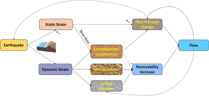
Nonetheless, there is a limited body of research documenting alterations in groundwater temperature and other physical-chemical parameters following an earthquake, especially in costal aquifers (Lee et al. 2021a; Miyakoshi et al. 2020; Shi and Wang 2014a; Tronin et al. 2002). Changes in groundwater temperature and permeability have been observed exclusively after significant earthquakes. Specifically, coseismic alterations stem from shifts in aquifer permeability, resulting from the unclogging of fractures induced by seismic waves (Shi and Wang 2014b). Dynamic responses primarily explain most hydrologic risks associated with seismic activities (Albini et al. 2013; De Boer and Sanders 2021). Earthquakes impact groundwater through the interaction of seismic forces with saturated porous media and the subsequent transfer of stress from solid grains to interstitial fluids (Medici et al. 2021; Medici and West 2021). In many cases alterations in groundwater within aquifers and shifts in surface water and groundwater quantities, as illustrated in Fig. 1 are linked to earthquakes.
Schematic presentation of the earthquake impact on soil and hydraulic response; + and - signs indicate the type of response (positive and negative), adapted after Mays (2010)
Changing water levels following an earthquake are classified as step-like changes, sustained changes, and oscillations (Lee et al. 2021b; Shi and Wang 2015). The near-field groundwater levels usually show a step-like change during an earthquake (Shi et al. 2013). Step-like changes are explained by the elastic—static strain or the undrained consolidation at a few source dimensions of earthquake epicenters (Galvez et al. 2021; Sukkarak et al. 2021). The observed sustained alterations in water levels in the far field, coupled with shifts in aquifer permeability induced by seismic waves, have emerged as plausible mechanisms for this response (Frind 1982; Panthi et al. 2022). Moreover, sustained changes are observed when the epicenter distance is more than one ruptured fault length (Shi and Wang 2014b). The enduring impacts are associated with lasting or temporary alterations in rock properties, manifesting in undrained contraction, liquefaction, or modifications in aquifer porosity and permeability (Sakr 1999).
Groundwater level oscillations in wells, induced by surface waves from a distant seismic event, result in the expansion and compression of aquifers, giving rise to resonant motion in high-transmissivity aquifers (Zhao et al. 2021; Zheng et al. 2021). After the 1999 Chi-Chi earthquake in Taiwan, there was a notable rise in groundwater levels in most near-field wells, attributable to aquifer expansions (Lai et al. 2021).
Furthermore, in the aftermath of the 2004 Sumatra earthquake, even at a distance of over 5000 km in Japan, approximately 50% of the monitoring wells registered fluctuations in groundwater levels that aligned with the recorded seismic strain (Ammon et al. 2005; Wang and Liu 2006).
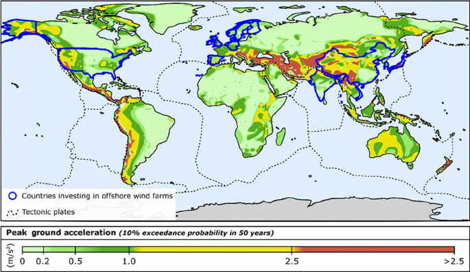
The global earthquake model (GEM) project compiled a historical catalog documenting non-instrumentally recorded earthquakes from 1000 to 1903 (Crowley et al. 2013). This catalog identifies earthquakes of magnitude seven or higher, encompassing approximately 825 events (Albini et al. 2013). The assessment relied on thorough archival research and historical evaluation. Figure 2 provides a comprehensive overview of the potential seismic impact across different regions, offering insights into the expected peak ground acceleration (PGA) levels with a statistical context for a half-century timeframe.
A global-scale seismic hazard map showing the PGA for 10% exceedance probability in 50 years, after Nikitas et al. (2019)
Groundwater in coastal aquifers is vital for various purposes, including water supply. Nevertheless, SWI impairs fresh groundwater and increases salinity (Abd-Elaty et al. 2022a). Assessment of the water quality indicators is essential for integrated water resource management and future sustainable development (Abd-Elaty et al. 2019). Groundwater is vital as ample groundwater storage supports the water supply during drought (Bear and Cheng 2010). Saltwater intrusion poses a serious challenge in coastal areas globally (Alfarrah and Walraevens 2018). Saltwater intrusion arises from human activities and natural events, including elevated sea levels, excessive pumping, non-proper surface water runoff management, non-sustainable land use practices, and artificial recharge (Abd-Elaty et al. 2021, 2022b; Bear et al. 1999).
The surface hydrologic system exhibits noteworthy responses to earthquake events, with particularly notable changes in stream flow that persist until the next rainfall event occurs (Muir-Wood and King 1993). The peak hydrograph can occur a day to several weeks after the earthquake (Matsumoto et al. 2003). Also, the peak flow in rivers typically occurs during periods of high precipitation or snowmelt when water inputs into the river system are at their highest (Kohout 1964). Shi et al. (2013) demonstrated that stress-induced alterations during earthquakes lead to the opening and closing of saturated micro-cracks in rocks. These dynamic changes result in fluctuations, causing either a decrease or increase in groundwater discharge into streams. Wong and Wang (2007) reported an increase in stream flow at Sespe Creek, California, following several earthquakes. Nevertheless, their analysis did not account for basin contraction or dilatation resulting from coseismic strain.
Hence, the observed alterations in the hydrologic system are attributed to the earthquake-induced dynamic strain. Nespoli et al. (2018) utilized the TOUGH2 code to examine the fluctuations in groundwater levels linked to the initial ML5.9 mainshock of the 2012 seismic sequence in Emilia, Italy. Furthermore, the findings align with the observations recorded in deep and shallow wells.
Our current understanding and literature review show a notable lack of research examining the influence of dynamic forces, particularly earthquakes, on saltwater intrusion. Thus, this study contributes to the existing body of knowledge by addressing a significant gap in the literature, exploring the hitherto understudied impact of seismic activity on saltwater intrusion. The findings enhance our understanding of the complex interactions between earthquakes and coastal aquifers, providing valuable insights for water resource management and disaster preparedness.
This study primarily aimed to examine the impact of earthquakes on SWI in coastal aquifers, focusing on Henry’s problem. Additionally, the research employs the real-world case of the Biscayne aquifer in Florida, USA, to investigate the seismic effects on SWI. The rest of the paper is organized as follows: Sect. 2 details the methodology dataset and provides brief information on the modeling process; Sect. 3 presents the key findings derived from the study; Sect. 4 delves into the significance of the findings and policy implications; and finally, Sect. 5 presents the main conclusions drawn from the study.
2 Materials and methods
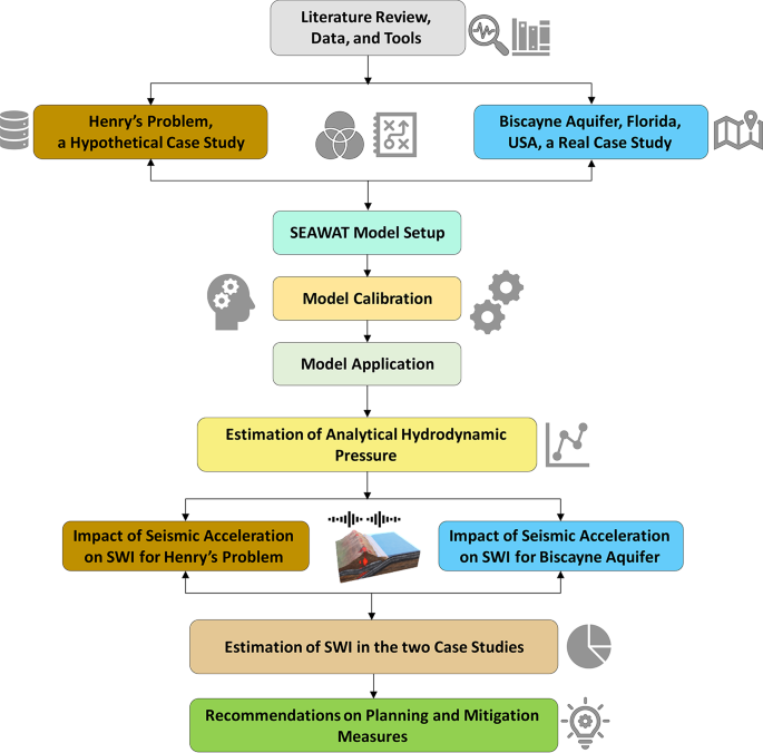
Figure 3 illustrates the flowchart outlining the investigation methodology for analyzing saltwater intrusion in coastal aquifers considering the impact of earthquake. The diagram encompasses a hypothetical case study of Henry’s problem and applies to the Biscayne aquifer in Florida, USA.
The modeling process was executed utilizing the SEAWAT code, incorporating the dynamics of variable groundwater density. In the initial phase of our proposed methodology, comprehensive data acquisition took place, encompassing hydrogeological and hydrological data crucial for simulating the intricate nature of variable-density groundwater. This groundwork laid the foundation for the subsequent steps in our analysis.
The second phase involved the setup and calibration of our numerical model, followed by its application to two selected case studies for simulating saltwater intrusion. Rigorous calibration ensures the accuracy and reliability of our model in representing real-world conditions, enhancing its predictive capabilities.
Moving forward, the third phase introduced an analytical solution for estimating hydrodynamic pressure, a critical factor in understanding the dynamics of SWI. Furthermore, we explored various scenarios to assess the impact of earthquakes on saltwater intrusion, providing valuable insights into potential vulnerabilities and risks associated with seismic activity.
Finally, our research culminates in the proposition of practical and sustainable recommendations to mitigate the adverse effects of earthquakes on saltwater intrusion. By combining advanced modeling techniques, comprehensive data analysis, and strategic mitigation strategies, we contribute to a more resilient and sustainable management of groundwater resources in the face of dynamic environmental challenges.
2.1 Numerical model
The finite difference of SEAWAT V.4.00.05 code was used in this study, an upgraded version of the previous codes (Guo and Bennett 1998; Guo and Langevin 2002) and SEAWAT 2000 (Langevin et al. 2003). This is a coupled version of MODFLOW (Harbaugh et al. 2000) and MT3DMS (Zheng 2006; Zheng and Wang 1999) designed to simulate three-dimensional, variable-density groundwater flow and multispecies transport.
The variable-density flow (VDF) process is used in SEAWAT code to solve the groundwater flow, according to Guo and Langevin (2002). While the integrated MT3D (IMT) process solved the following form of the advection-dispersion equation and is described by Zheng and Wang (1999).
2.2 Hypothetical case study of Henry’s problem
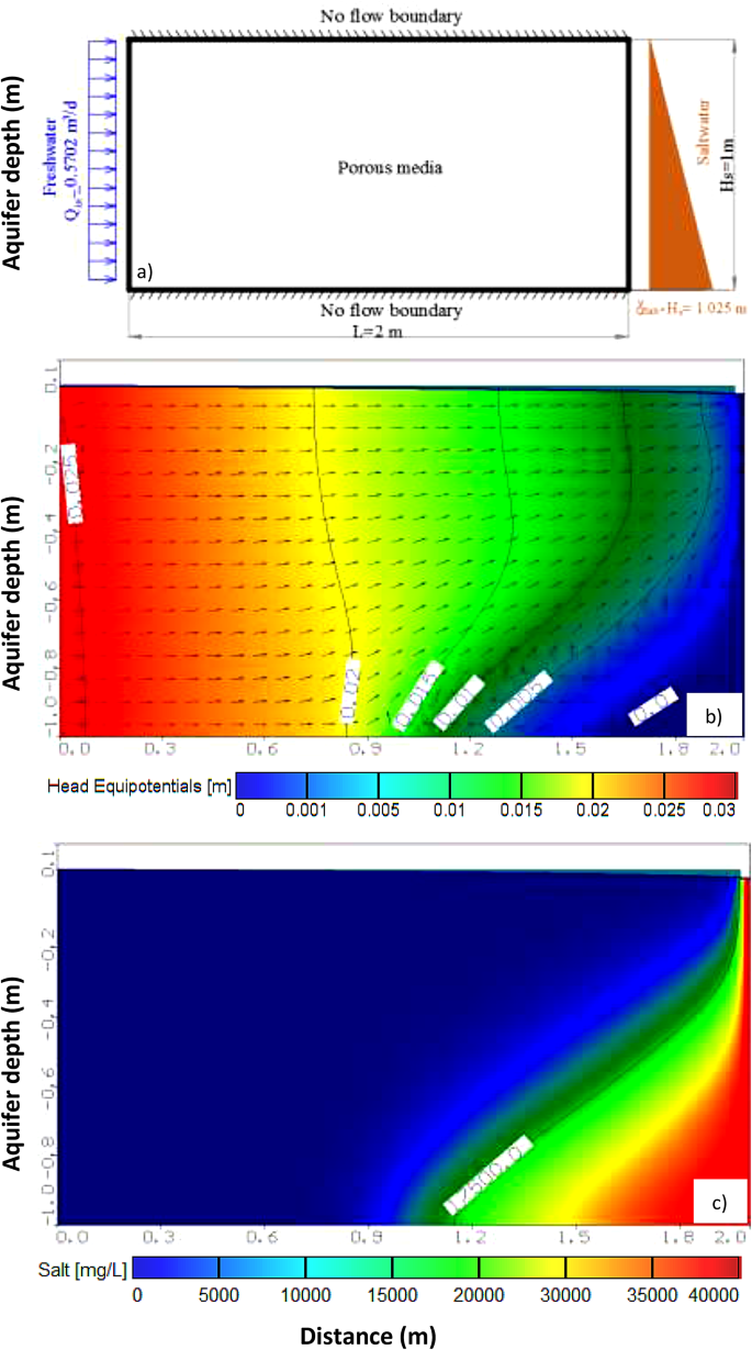
SEAWAT code is calibrated and then used in a hypothetical case study, Henry’s problem (Henry 1959, 1964), to investigate the SWI. Henry’s problem domain is 2 m (horizontal), 1 m (vertical), and 10 cm wide. Figure 4a presents the definition sketch of case study parameters using Henry’s problem. It shows the problem domain and boundary conditions.
The prevailing model outcomes for groundwater heads are visually presented in Fig. 4b, encapsulating the foundational scenario of our study. This graphical representation offers a succinct portrayal, facilitating a comprehensive understanding of our system’s spatial distribution and magnitude of groundwater heads. Simultaneously, Fig. 4c unveils the salinity results derived from the SEAWAT code, showcasing a remarkable concordance with other established models employed to address Henry’s problem.
Notably, our findings align closely with the seminal works of Frind (1982), Henry (1964b), and Segol (1994). The observed congruence substantiates the reliability and robustness of our model, as its outcomes harmonize with those of well-recognized hydrological studies. The results of equi-concentration lines 17,000 ppm reached 82.75 cm from the seaside, respectively.
2.3 The Biscayne aquifer case study
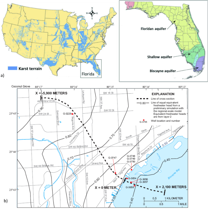
The application of numerical simulation through the SEAWAT code was extended to the Biscayne aquifer in Florida, USA. This endeavor aimed to delve into the nuanced dynamics of SWI under the influence of seismic forces. Figure 5a represents the aquifer domain under consideration in the picturesque yet hydrologically significant at the Coconut Grove area.
The delineated aquifer domain, illustrated in Fig. 5b, is a rectangular expanse spanning 8 km, reaching a depth of 40 m below mean sea level and extending its width to 300 m. This carefully defined domain is crucial for our simulation, capturing the essential hydrogeological features and dimensions necessary for a comprehensive analysis of SWI dynamics under seismic accelartion.
Kohout (1964) investigated the groundwater flow using monitoring wells in the Cutler Ridge area (Fig. 5a; near Miami) in south-eastern Florida. The research findings unveil a significant aspect of hydrological dynamics, indicating that approximately 12.5% of the groundwater discharge into Biscayne Bay undergoes circulation through the aquifer. Moreover, this circulation is notably concentrated within 130 m of the shoreline (Alarcon et al. 2022). These findings underscores the groundwater movement’s localized and impactful nature in the studied area, particularly along the coastal fringe. The 12.5% circulation through the aquifer contributes to the intricate balance of the Biscayne Bay ecosystem and emphasizes the critical role of nearshore hydrogeological processes.
This insight holds implications for our understanding of the spatial distribution of groundwater discharge, shedding light on the hydrological connectivity between the aquifer system and Biscayne Bay. The Biscayne aquifer has been a focal point in numerous studies examining SWI concerns. Notably, Lee and Cheng (1974); Langevin (2001); Abd-Elaty et al. (2022a) have contributed to this body of research. Their work advanced the understanding of SWI dynamics by employing steady-state 2-D finite element models.
By focusing on this specific geographical context, we not only enhance the accuracy of our simulation but also contribute valuable insights into the potential impact of seismic events on the delicate balance of freshwater and saltwater in the Biscayne aquifer. This localized exploration provides a nuanced perspective on the interplay between earthquake forces and aquifer behavior, adding depth to our understanding of SWI dynamics in the unique hydrogeological setting of Coconut Grove, Florida.
2.4 Aquifer geometry and boundary conditions
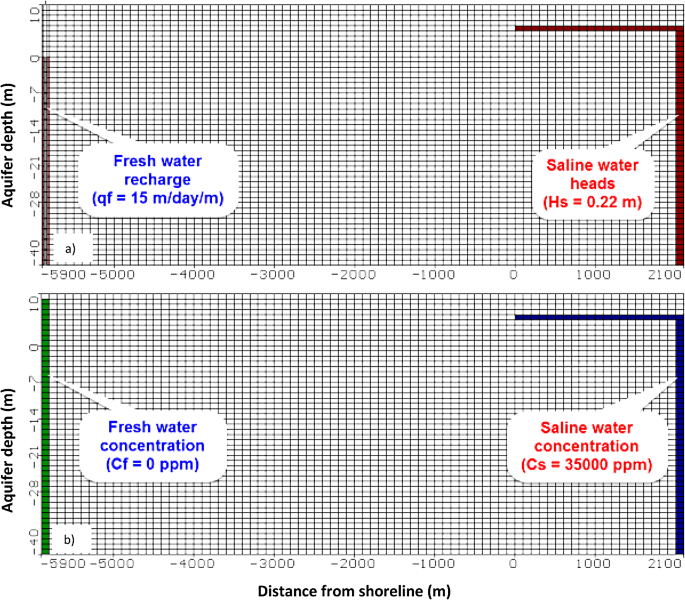
Figures 6a and 6b provide a schematic representation of the study area, illustrating the geometry and the prescribed model boundary conditions within the aquifer. These visual depictions serve as essential references, offering a clear and concise overview of the spatial configuration and environmental constraints considered in our analysis. The aquifer’s detailed data and information were deduced from the available literature and reported by Langevin (2001). A 2D model was used for the Biscayne aquifer with a model domain including 50 layers and 80 columns.
In a single row, each cell dimension is defined as 100 m x 1 m x 1 m, corresponding to (Δx x Δz x Δy) dimensions, respectively. Drawing from existing literature, specific conditions are imposed on the side where 0 ≤ x ≤ 2100 m: a designated head (i.e., seawater level) is set, characterized by seawater concentrations of 35000 ppm, and a constant head positioned 0.22 m above mean sea level (AMSL). Conversely, on the land side where x = -5900 m, the concentration is equated to freshwater by 0 ppm and the freshwater recharge by 15 m³/day/m (Langevin 2001).
2.5 Aquifer hydraulic properties
The hydraulic parameters for the hypothetical case study of Henry’s problem and real study area of Coconut Grove are used in the model simulation. Also, it have been investigated and reported by Langevin (2001) and are presented in Table 1.
This table outlines various boundary conditions, hydraulic parameters, and solution methods for a model simulating groundwater dynamics, particularly in the context of Henry’s problem and the Biscayne aquifer. The following are key points summarizing the most important parameters:
-
Flow characteristics
Inland freshwater Flux (Qin) values quantify the rate of freshwater movement, distinguishing between Henry’s problem and the Biscayne aquifer.
Saltwater head (hs) values delineate the head of the saltwater interface, a critical parameter for modeling seawater intrusion (Table 1).
-
Concentration profiles
Seaside saltwater and landside fresh water concentration values (Cs and Cf) define the conditions for salinity, providing insights into the distribution of saltwater and freshwater at different boundaries (Table 1).
-
Hydraulic properties
Horizontal and vertical hydraulic conductivity (Kh and Kv) values describe the aquifer’s permeability, influencing groundwater flow.
Also, the aquifer porosity (n) affects the volume of void spaces in the aquifer, impacting fluid storage, the specific storage is volume of water per volume of aquifer released under a unit decline in hydraulic head. The variable-density parameters used in the coupled system of flow and transport equations are longitudinal and transverse dispersivities (αL, αT), and molecular diffusion coefficient (D*) characterize fluid movement and dispersion (Table 1).
-
Density and recharge
Freshwater and saltwater density values (ρf and ρs) are crucial for calculating buoyancy effects. Vertical and horizontal hydraulic recharge values provide insights into water input and potential replenishment and changing the fluid density (Table 1).
-
Modeling approach
The chosen implicit finite-difference solver with upstream-weighting (GCG) and the specified grid parameters (i.e., number of columns, rows, and initial time step) detail the numerical methodology used for simulation (Table 1).
In summary, the table synthesizes critical parameters for modeling groundwater behavior, facilitating a comprehensive understanding of the hydrogeological system in Henry’s problem and the Biscayne aquifer. These details are crucial for accurately simulating, predicting, and managing groundwater flow and salinity dynamics.
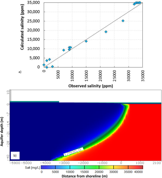
The calibration of the Biscayne Aquifer model was carefully conducted, aligning with field data obtained from 21 observation wells dedicated to monitoring the concentration of total dissolved solids. These observations were derived from published data by Langevin (2001), utilizing a network of 21 monitoring wells, as illustrated in Fig. 7a.
Results of SEAWAT at Biscayne aquifer for a) calibration between the field data obtained from Langevin (2001) and b) salinity, the vertical distribution of 0.5 isochlor (17,500 ppm)
The calibration process yielded insightful results. The residuals, representing the differences between observed and simulated values, ranged from − 5552 ppm to 388.20 ppm. The mean residual was calculated at 347.05 ppm, providing a central measure of the model’s accuracy. The root mean square (RMS), a comprehensive indicator of model performance, was determined to be 2085.70 ppm. Additionally, the standard error of the estimate was quantified at 459.88 ppm, offering a measure of the precision of the model’s predictions. Notably, the normalized RMS, a percentage expressing the RMS relative to the observed data range, stood at 6.13%. This metric is particularly valuable as it gauges the relative accuracy of the model in the context of the observed data variability (Chai and Draxler 2014).
In summary, the calibration process, anchored in a robust dataset and employing multiple observation wells, resulted in a model that effectively captures the intricacies of total dissolved solids concentration in the Biscayne aquifer. The reported metrics provide a comprehensive assessment of the model’s performance, instilling confidence in its predictive capabilities and contributing valuable insights to understanding groundwater dynamics in the studied area.
2.6 Analytical solution of hydrodynamic pressure
The analytical solution employed in this study computes the repercussions of an earthquake on water pressure. This method considers the dynamic and temporary effects of horizontal acceleration exerted on the reservoir. This analytical approach provides a comprehensive understanding of how such accelerations influence and alter water pressure dynamics by delving into the intricate interplay of forces during seismic events. This seismic force leads to a momentary surge in water pressure, estimating the system’s dynamic response to the seismic event. This hydrodynamic force (Pe) is given by Zangger’s formula (1952) (Neuman and Wilson 1980), Eqs. 1, 2, and 3.
where Cm: is the maximum value of pressure coefficient [-], \(\theta\): is the angle in degree, which the upstream face of the dam makes with the horizontal; kh: the fraction of gravity adopted for horizontal acceleration (αh) such as 0.10 or 0.20 [-], g: the acceleration gravity [LT-2], γs: the saline water density [ML-3], and h: the hydrostatic saline water head [L].
3 Results
This section delves into the comprehensive analysis of groundwater dynamics, specifically focusing on variable density, and presents the results derived from the seismic impact on groundwater aquifers. The simulation, a pivotal aspect of our investigation, was executed utilizing SEAWAT code for Henry’s problem and the Biscayne aquifer. This approach enables a nuanced exploration of how earthquakes influence saltwater intrusion in these hydrogeological contexts. The integration of SEAWAT code ensures a robust and sophisticated modeling framework, allowing us to unravel the intricacies of seismic interactions with groundwater systems and enhance our understanding of the potential implications on SWI.
3.1 Effect of the earthquake on SWI on Henry’s problem
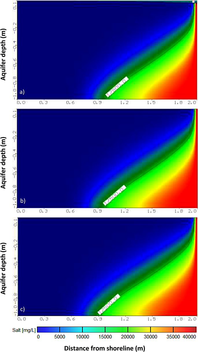
The seismic acceleration intensities considered in this study were 0.1 g, 0.2 g, and 0.3 g. The resulting earthquake forces translated into hydrostatic seawater pressures of 7.35 cm, 14.70 cm, and 22.05 cm, respectively, considering the original head of 1 m in Henry’s problem. For an in-depth examination of saltwater intrusion, encompassing hydrostatic seawater pressure and earthquake forces, we incorporated total head values of 1.0735 m, 1.147 m, and 1.2205 m into the model. The outcomes of this analysis, revealing the impact of saltwater intrusion, are depicted in Fig. 8a and b, and 8c for the respective total head values of 1.0735 m, 1.147 m, and 1.2205 m.
These visual representations shows the intricate relationship between seismic forces and hydrostatic pressures in influencing saltwater intrusion, offering valuable insights into the nuanced responses of the aquifer system across different earthquake intensities. Specifically, the intrusion depths in the aquifer reached 92.63 cm, 95.75 cm, and 101.25 cm, compared to the baseline of 82.75 cm for an isochlorine concentration of 17,500 ppm.
These findings highlight a discernible increase in saltwater intrusion within coastal aquifers under the influence of earthquake forces. The observed variations underscore the need for a comprehensive understanding of the interplay between seismic events and hydrogeological systems, providing critical information for effective management and mitigation strategies in vulnerable coastal regions.
3.2 Effect of the earthquake on SWI for Biscayne aquifer
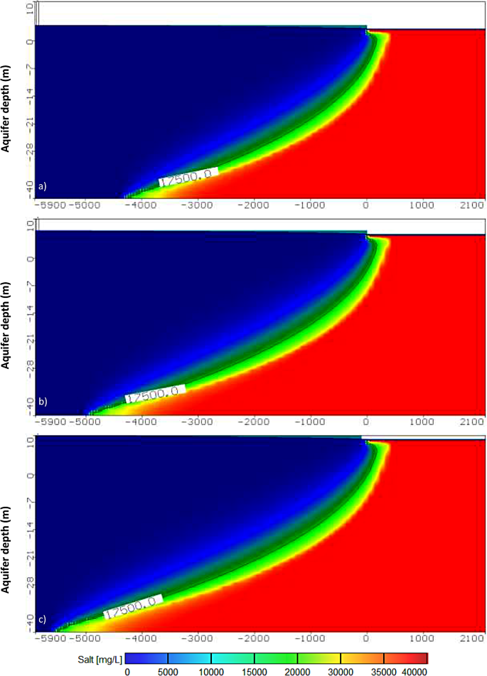
This scenario was examined to delineate the freshwater-seawater interface dynamics under the influence of seismic activity. The aquifer, with a depth of 40 m, experiences varying equivalent hydrostatic seawater pressures of 2.94 m, 5.88 m, and 8.82 m for horizontal accelerations of 0.1 g, 0.20 g, and 0.30 g, respectively. The numerical model effectively incorporates these equivalent heads, visually representing the evolving interface in response to seismic forces (Fig. 9). The initial configuration established the groundwater table at the landside and other relevant parameters. In Fig. 9a–c, the model’s salinity outcomes are depicted, showcasing the isochlorine concentration of 17,500 ppm extending to distances of 4178 m, 4572 m, and 5470 m for horizontal accelerations of 0.10 g, 0.20 g, and 0.3 g, respectively, compare with 3610 m at the base case. The distance is calculated from the shore line (X = 0 m) at the base of the aquifer. Additionally, there is an incremental salt water intrusion of 568 m, 962 m, and 1860 m, respectively.
.
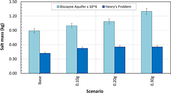
These findings underscore the susceptibility of the aquifer to heightened Saltwater Intrusion (SWI) in response to the dynamic forces exerted by seismic events. Figure 10 shows results from Henry’s problem, wherein the base case exhibits a salinity mass of 0.42209 kg. These insights contribute to a comprehensive understanding of the aquifer’s vulnerability and the potential for increased SWI under seismic influence. Furthermore, the salinity mass demonstrated an increase, reaching 0.52716 kg, 0.55598 kg, and 0.55611 kg at horizontal accelerations of 0.10 g, 0.20 g, and 0.30 g, respectively, as compared to the baseline value of 0.42209 kg in the Henry problem. The Henry’s problem salinity increased by 24.90%, 31.70%, and 41.70% compare with the base case.
The base case’s salinity mass was recorded at 891,486 kg in the Biscayne aquifer scenario.
Moreover, the introduction of horizontal accelerations at 0.1 g, 0.20 g, and 0.30 g resulted in an elevation of the equivalent hydrostatic seawater pressure to 2.94 m, 5.88 m, and 8.82 m, respectively. Consequently, the salinity mass escalated to 999,342 kg, 1,086,460 kg, and 1,298,470 kg, signifying a notable impact of dynamic earthquake acceleration on groundwater levels within coastal aquifers and the consequent influence on aquifer salinity (Fig. 10). The Biscayne aquifer salinity was increased by 12.10%, 21.90%, and 45.70% compare with the baseline case.
4 Discussion
The global concern on the saltwater intrusion in coastal regions is compounded by various factors, including over-pumping driven by population growth, scarce rainfall, rising sea levels due to climate change, and seismic activities. Despite extensive documentation of anthropogenic influences on SWI, there is a notable gap in research particulary regarding the impact of earthquakes on SWI and its associated environmental consequences. The intersection of seismic forces with SWI represents an intricate and understudied aspect, necessitating a deeper exploration to comprehensively understand and address the multifaceted challenges posed by the dynamic interplay of geological and anthropogenic factors in coastal aquifers (Stein et al. 2019).
Henry (1964) was among the pioneering researchers who discovered that earthquakes in southern California induced phase shifts in water levels attributable to tidal strain. Moreover, the dynamic force of seismic activities was observed to enhance aquifer permeability. Notably, this augmentation in permeability might be temporary, influenced by potential biogeochemical processes that could reseal or obstruct fractures generated during seismic events. The duration and sustainability of this permeability increase are contingent upon the geological characteristics of the aquifer formation (Matsumoto et al. 2003; Reese and Cunningham 2000). The sedimentary geological formations are generally more prone to SWI than mantle-originated ophiolites (Maury and Balaji 2015). Hence, the extent of geological formation heterogeneity plays a pivotal role on SWI. Low levels of heterogeneity seem to exert minimal impact on the thickness of mixing zones, distinguishing between freshwater and saltwater.
Conversely, when aquifer properties exhibit significant variations in heterogeneity, there is a profound influence on the dynamic behavior of SWI. The intricate interplay of heterogeneity in geological formations emerges as a critical factor, demonstrating that the magnitude of these variations significantly shapes the dynamics of saltwater intrusion within the aquifer system. Shi and Wang (2015) scrutinized alterations in groundwater levels post the Wenchuan earthquake, employing data from three wells located approximately 300 km away from the epicenter. Their findings emphasized that permeability variations predominantly contributed to shifts in groundwater levels across the three wells. The seismic activities induced hydrostatic pressure changes, showcasing a direct correlation with water-level fluctuations.
Additionally, in the aftermath of a seismic event, the geological structure of the aquifer may incur damage, intensifying SWI. Consequently, substantial pumping from shallow freshwater layers can act as a catalyst, prompting saltwater movement from deeper zones and facilitating upward migration into the unconfined freshwater zone (Abd-Elaty et al. 2022c). This intricate interplay underscores the interconnected dynamics between seismic forces, aquifer structure, and human activities impacting the delicate balance of groundwater salinity (Sakr 1999; Werner et al. 2013).
In contrast, our study’s results reveal a noteworthy distinction: In Henry’s problem, the mass salt concentration attains a saturation point despite escalating horizontal acceleration. Surprisingly, this saturation phenomenon is not replicated in the Biscayne aquifer, where the mass salt concentration continues to increase alongside horizontal acceleration. This discrepancy underscores the unique response of different aquifer systems to seismic forces.
Given the increasing frequency of earthquakes globally, often resulting in significant human casualties, it becomes imperative to assess their environmental consequences, particularly regarding SWI. Our findings indicate that understanding the varied impacts of seismic activities on aquifers is crucial for informed environmental management and sustainable groundwater resource utilization.
Therefore, in that context, it is essential to develop adaptation and manage the impact of seismic activities, earthquakes on SWI, and related environmental aspects such as the salinization of groundwater and land (Szota et al. 2015). In this regard, several measures have proved effective against SWI (Abd-Elaty et al. 2022c). First, monitoring coastal groundwater systems holds paramount importance in unraveling the intricacies of SWI. Precise measurements of groundwater levels become instrumental in capturing accurate data regarding depth variations and salinity fluctuations. In essence, continuous monitoring of coastal aquifers is a foundational step toward understanding SWI dynamics comprehensively (Soltane et al. 2022; Werner et al. 2013).
Findings resulting from this study underscore the significant impact of seismic activities on groundwater levels and aquifer salinity in coastal areas. Earthquake-induced forces can lead to increased saltwater intrusion, which has implications for the management and sustainability of coastal aquifers. These results call for careful consideration when assessing the potential consequences of seismic events on groundwater resources.
5 Conclusions
Coastal water resources,vital for future development, face looming threats of salinization spurred by seismic activities, especially earthquakes. This study investigates the hypothetical case of Henry’s problem and the Biscayne aquifer in Florida, USA, aiming to discern the seismic impact on SWI in coastal regions. The simulation considers three scenarios: horizontal acceleration (αh) by 0.10 g, 0.20 g, and 0.30 g, where the SWI reached 92.63 cm, 95.75 cm, and 101.25 cm compared with 82.75 cm at the base case for the equi-concentration line 17,500 for Henry’s problem.
For the Biscayne aquifer, the equivalent hydrostatic seawater pressure reached 2.94 m, 5.88 m, and 8.82 m for a horizontal acceleration of 0.1 g, 0.20 g, and 0.30 g, respectively, with the intrusion of isochlorine 17,500 ppm reaching 4178 m, 4572 m, and 5740 m compared with 3610 m from shoreline measured at the bottom of the aquifer. The horizontal seismic accelerations increased saltwater intrusion by 568 m, 962 m, and 1860 m, respectively compare to the base case. In addition, increasing the saline water heads due to seismic forces will affect the water and land’s salinity and reduce crop productivity. By shedding light on the intricate dynamics between seismic forces and coastal aquifers, this study provides pivotal insights for strategic water resource management. The findings emphasize the necessity of seismic-aware planning, especially in coastal regions, to fortify future development against the challenges posed by earthquake-induced salinization. Thus, future research should explore the cyclical effect of seismic acceleration on SWI and develop cost-effective strategies to mitigate or potentially prevent deep inland SWI.
Data availability
Not applicable.
References
Abd-Elaty I, Sallam GA, Straface S, Scozzari A (2019) Effects of climate change on the design of subsurface drainage systems in coastal aquifers in arid/semi-arid regions: Case study of the Nile delta. Sci Total Environ 672:283–295
Abd-Elaty I, Shahawy AE, Santoro S, Curcio E, Straface S (2021) Effects of groundwater abstraction and desalination brine deep injection on a coastal aquifer. Sci Total Environ 795:148928
Abd-Elaty I, Kuriqi A, Bhat SA, Zelenakova M (2022a) Sustainable management of two-directional lateral and Upcoming Saltwater Intrusion in Coastline Aquifers to alleviate Water Scarcity. https://doi.org/10.1002/hyp.14646. Hydrological Processes n/a:e14646
Abd-Elaty I, Kushwaha NL, Grismer ME, Elbeltagi A, Kuriqi A (2022b) Cost-effective management measures for coastal aquifers affected by saltwater intrusion and climate change. Sci Total Environ 836:155656. https://doi.org/10.1016/j.scitotenv.2022.155656
Abd-Elaty I, Kushwaha NL, Grismer ME, Elbeltagi A, Kuriqi A (2022c) Cost-effective management measures for coastal aquifers affected by saltwater intrusion and climate change. Sci Total Environ 836:155656. https://doi.org/10.1016/j.scitotenv.2022.155656
Alarcon VJ, Linhoss AC, Mickle PF, Kelble CR, Fine A (2022) Estimation of Groundwater and Salinity for the Central Biscayne Bay Coast, Florida, USA. In: Gervasi O, Murgante B, Misra S, Rocha AMAC, Garau C (eds) Computational science and its applications – ICCSA 2022 Workshops. Springer International Publishing, Cham, pp 594–606
Albini P, Musson RMW, Gomez Capera AA, Locati M, Rovida A, Stucchi M, Viganò D (2013) Global historical earthquake archive and catalogue (1000–1903). Pavia, Italy
Alfarrah N, Walraevens K (2018) Groundwater overexploitation and seawater intrusion in coastal areas of arid and semi-arid regions. Water 10:143
Ammon CJ, Ji C, Thio H-K, Robinson D, Ni S, Hjorleifsdottir V, Kanamori H, Lay T, Das S, Helmberger D (2005) Rupture process of the 2004 Sumatra-Andaman earthquake. Science 308:1133–1139
Bear JJ, Cheng H-DA (2010) Water Balance and Complete Flow Model. Modeling Groundwater Flow and Contaminant Transport. Springer. pp 161–249
Bear J, Cheng AH-D, Sorek S, Ouazar D, Herrera I (1999) Seawater intrusion in coastal aquifers: concepts, methods and practices. Springer Science & Business Media
Chai T, Draxler RRJG (2014) Root mean square error (RMSE) or mean absolute error (MAE). 7:1525–1534
Crowley H, Pinho R, Pagani M, Keller N (2013) 30 - Assessing global earthquake risks: the Global Earthquake Model (GEM) initiative. In: Tesfamariam S, Goda K (eds). Handbook of Seismic Risk Analysis and Management of Civil Infrastructure Systems. Woodhead Publishing. pp 815–838
De Boer JZ, Sanders DT (2021) Earthquakes in human history. Earthquakes in human history. Princeton University Press
Doocy S, Daniels A, Packer C, Dick A, Kirsch TD (2013) The human impact of earthquakes: a historical review of events 1980–2009 and systematic literature review. PLoS Curr 5. https://doi.org/10.1371/currents.dis.67bd14fe457f1db0b5433a8ee20fb833
Frind EO (1982) Simulation of long-term transient density-dependent transport in groundwater. Adv Water Resour 5:73–88. https://doi.org/10.1016/0309-1708(82)90049-5
Galvez P, Petukhin A, Somerville P, Ampuero JP, Miyakoshi K, Peter D, Irikura K (2021) Multicycle Simulation of Strike-Slip Earthquake Rupture for Use in Near‐Source Ground‐Motion simulations. Bull Seismol Soc Am 111:2463–2485
Guo W, Bennett GD (1998) Simulation of saline/fresh water flows using MODFLOW. Poeter, E, and others, MODFLOW’98 Conference, Golden, Colorado, 1998, Proceedings: Golden, Colorado. pp 267–274
Guo W, Langevin CD (2002) User’s guide to SEAWAT; a computer program for simulation of three-dimensional variable-density ground-water flow
Harbaugh AW, Banta ER, Hill MC, McDonald MG (2000) Modflow-2000, the u. s. geological survey modular ground-water model-user guide to modularization concepts and the ground-water flow process
Henry HR (1959) Salt intrusion into fresh-water aquifers. J Phys Res 64:1911–1919. https://doi.org/10.1029/JZ064i011p01911
Henry HR (1964) Effect of Dispersion on Salt Encroachment in Coastal Aquifers. U.S. Geol. Surv., Water-Supply Pap. pp 70–84
Kohout FA (1964) The flow of fresh water and salt water in the Biscayne Bay aquiger of the Miami area, Florida. Sea water in coastal aquifers. US Geol Surv, Water Suply Pap:12–32
Lai G, Lei X, Jiang C, Wang W, Gong H (2021) Multiple mechanisms of coseismic water level changes at the Rongchang well in a seismically active area in China. Tectonophysics 819:229083. https://doi.org/10.1016/j.tecto.2021.229083
Langevin CD (2001) Simulation of ground-water discharge to Biscayne Bay, southeastern Florida
Langevin CD, Shoemaker WB, Guo W (2003) Modflow-2000, the US geological survey modular ground-water model–documentation of the SEAWAT-2000 version with the variable-density flow process (VDF) and the integrated MT3DMS transport process (IMT)
Lee CH, Cheng RTS (1974) On seawater encroachment in coastal aquifers. Water Resour Res 10:1039–1043
Lee HA, Hamm S-Y, Woo NC (2021a) Pilot-Scale Groundwater Monitoring Network for Earthquake Surveillance and Forecasting Research in Korea. Water
Lee S-H, Lee JM, Moon S-H, Ha K, Kim Y, Jeong DB, Kim YJHJ (2021b) Seismically induced changes in groundwater levels and temperatures following the ML 5.8 (ML 5.1) Gyeongju earthquake in South Korea. 29:1679–1689
Matsumoto N, Kitagawa G, Roeloffs EA (2003) Hydrological response to earthquakes in the Haibara well, central Japan–I. Groundwater level changes revealed using state space decomposition of atmospheric pressure, rainfall and tidal responses. Geophys J Int 155:885–898
Maury S, Balaji S (2015) Application of resistivity and GPR techniques for the characterization of the coastal litho-stratigraphy and aquifer vulnerability due to seawater intrusion. Estuar Coast Shelf Sci 165:104–116. https://doi.org/10.1016/j.ecss.2015.09.006
Mays DC (2010) Contrasting clogging in granular media filters, soils, and dead-end membranes. J Environ Eng 136:475–480
Medici G, West LJ (2021) Groundwater flow velocities in karst aquifers; importance of spatial observation scale and hydraulic testing for contaminant transport prediction. Environ Sci Pollut Res 28:43050–43063. https://doi.org/10.1007/s11356-021-14840-3
Medici G, Smeraglia L, Torabi A, Botter C (2021) Review of modeling approaches to groundwater flow in deformed carbonate aquifers. Groundwater 59:334–351
Miyakoshi A, Taniguchi M, Ide K, Kagabu M, Hosono T, Shimada J (2020) Identification of changes in subsurface temperature and groundwater flow after the 2016 Kumamoto earthquake using long-term well temperature–depth profiles. J Hydrol 582:124530. https://doi.org/10.1016/j.jhydrol.2019.124530
Muir-Wood R, King GCP (1993) Hydrological signatures of earthquake strain. J Geophys Research: Solid Earth 98:22035–22068. https://doi.org/10.1029/93JB02219
Nespoli M, Belardinelli ME, Gualandi A, Serpelloni E, Bonafede M (2018) Poroelasticity and Fluid Flow modeling for the 2012 Emilia-Romagna earthquakes: hints from GPS and InSAR Data. Geofluids 2018:4160570. https://doi.org/10.1155/2018/4160570
Neuman SP, Wilson LG (1980) Developing Methods for On-site Determination of Unsaturated and Saturated Hydraulic Conductivity above the Water Table
Nikitas G, Bhattacharya S, Vimalan N, Demirci HE, Nikitas N, Kumar P (2019) 10 - Wind power: A sustainable way to limit climate change. In: Letcher TM (ed). Managing Global Warming. Academic Press. pp 333–364
Oluwafemi JO, Ofuyatan OM, Sadiq OM, Oyebisi SO, Abolarin JS, Babaremu KO (2018) Review of world earthquakes. Int J Civ Eng Technol 9:440–464
Panthi J, Pradhanang SM, Nolte A, Boving TB (2022) Saltwater intrusion into coastal aquifers in the contiguous United States — a systematic review of investigation approaches and monitoring networks. Sci Total Environ 836:155641. https://doi.org/10.1016/j.scitotenv.2022.155641
Reese RS, Cunningham KJ (2000) Hydrogeology of the gray limestone aquifer in southern Florida. USGS
Sakr SA (1999) Validity of a sharp-interface model in a confined coastal aquifer. Hydrogeol J 7:155–160. https://doi.org/10.1007/s100400050187
Segol G (1994) Classic groundwater simulations: proving and improving numerical models. Englewood Clifts, Prentice Hall, NJ
Shi Z, Wang G (2014a) Hydrological response to multiple large distant earthquakes in the Mile well, China. J Geophys Research: Earth Surf 119:2448–2459
Shi Z, Wang G (2014b) Hydrological response to multiple large distant earthquakes in the Mile well. China 119:2448–2459. https://doi.org/10.1002/2014JF003184
Shi Z, Wang G (2015) Sustained groundwater level changes and permeability variation in a fault zone following the 12 May 2008, mw 7.9 Wenchuan earthquake. 29:2659–2667. https://doi.org/10.1002/hyp.10387
Shi Z, Wang G, Liu C (2013) Co-seismic Groundwater Level Changes Induced by the May 12, 2008 Wenchuan Earthquake in the Near Field. Pure appl Geophys 170:1773–1783. https://doi.org/10.1007/s00024-012-0606-1
Soltane MA, Mimoune M, Guettiche A (2022) Earthquake-induced impact scenario assessment for the historical center of Skikda. Algeria Bull Earthq Eng 20:5677–5719. https://doi.org/10.1007/s10518-022-01437-5
Stein S, Yechieli Y, Shalev E, Kasher R, Sivan O (2019) The effect of pumping saline groundwater for desalination on the fresh–saline water interface dynamics. Water Res 156:46–57. https://doi.org/10.1016/j.watres.2019.03.003
Sukkarak R, Tanapalungkorn W, Likitlersuang S, Ueda K (2021) Liquefaction analysis of sandy soil during strong earthquake in Northern Thailand. Soils Found 61:1302–1318. https://doi.org/10.1016/j.sandf.2021.07.003
Szota C, Farrell C, Livesley SJ, Fletcher TD (2015) Salt tolerant plants increase nitrogen removal from biofiltration systems affected by saline stormwater. Water Res 83:195–204. https://doi.org/10.1016/j.watres.2015.06.024
Tronin AA, Hayakawa M, Molchanov OA (2002) Thermal IR satellite data application for earthquake research in Japan and China. J Geodyn 33:519–534. https://doi.org/10.1016/S0264-3707(02)00013-3
Upchurch S, Scott TM, Alfieri M, Fratesi B, Dobecki TL (2019) The Karst systems of Florida: understanding Karst in a Geologically Young Terrain. Springer, Cham, pp 1–15. https://doi.org/10.1007/978-3-319-69635-5
Wang X, Liu PLF (2006) An analysis of 2004 Sumatra earthquake fault plane mechanisms and Indian Ocean tsunami. J Hydraul Res 44:147–154. https://doi.org/10.1080/00221686.2006.9521671
Werner AD, Bakker M, Post VEA, Vandenbohede A, Lu C, Ataie-Ashtiani B, Simmons CT, Barry DA (2013) Seawater intrusion processes, investigation and management: recent advances and future challenges. Adv Water Resour 51:3–26. https://doi.org/10.1016/j.advwatres.2012.03.004
Wong A, Wang C-Y (2007) Field relations between the spectral composition of ground motion and hydrological effects during the 1999 Chi-Chi (Taiwan) earthquake. 112. https://doi.org/10.1029/2006JB004516
Zhao J, Lin J, Wu J, Wu J (2021) Impact of climate change on multi-objective management of seawater intrusion in coastal karst aquifers in Zhoushuizi district of Dalian City, China. Hydrogeol J 29:2329–2346. https://doi.org/10.1007/s10040-021-02383-3
Zheng C (2006) MT3DMS v5. 2. Supplemental User‘s Guide Department of Geological Sciences, University of Alabama
Zheng C, Wang PP (1999) MT3DMS: a modular three-dimensional multispecies transport model for simulation of advection, dispersion, and chemical reactions of contaminants in groundwater systems; documentation and user’s guide
Zheng H, Wenxi L, Yue F, Tiansheng M, Jin L, Jiuhui L (2021) Optimal location of cutoff walls for seawater intrusion. Appl Water Sci 11:179. https://doi.org/10.1007/s13201-021-01514-1
Acknowledgements
The authors express their sincere appreciation to the Department of Water and Water Structures Engineering, Faculty of Engineering, Zagazig University Egypt, for the instrument and software facilities. Alban Kuriqi is grateful for the Foundation for Science and Technology’s support through funding UIDB/04625/2020 from the research unit CERIS (DOI: 10.54499/UIDB/04625/2020).
Funding
Not applicable.
Open access funding provided by FCT|FCCN (b-on).
Author information
Authors and Affiliations
Contributions
Conceptualization, methodology, software, validation, formal analysis, investigation, resources, data curation, writing-original draft preparation, writing-review and editing, visualization: A. K., and I. A. Supervision, and project administration: A. K.
Corresponding author
Ethics declarations
Conflict of interest
The authors declare no conflict of interest.
Competing interests
The authors declare no competing interests.
Additional information
Publisher’s Note
Springer Nature remains neutral with regard to jurisdictional claims in published maps and institutional affiliations.
Rights and permissions
Open Access This article is licensed under a Creative Commons Attribution 4.0 International License, which permits use, sharing, adaptation, distribution and reproduction in any medium or format, as long as you give appropriate credit to the original author(s) and the source, provide a link to the Creative Commons licence, and indicate if changes were made. The images or other third party material in this article are included in the article’s Creative Commons licence, unless indicated otherwise in a credit line to the material. If material is not included in the article’s Creative Commons licence and your intended use is not permitted by statutory regulation or exceeds the permitted use, you will need to obtain permission directly from the copyright holder. To view a copy of this licence, visit http://creativecommons.org/licenses/by/4.0/.
About this article
Cite this article
Kuriqi, A., Abd-Elaty, I. Groundwater salinization risk in coastal regions triggered by earthquake-induced saltwater intrusion. Stoch Environ Res Risk Assess 38, 3093–3108 (2024). https://doi.org/10.1007/s00477-024-02734-y
Accepted:
Published:
Issue Date:
DOI: https://doi.org/10.1007/s00477-024-02734-y


