Abstract
Recently, unmanned aerial vehicles (UAVs) or drones have emerged as a ubiquitous and integral part of our society. They appear in great diversity in a multiplicity of applications for economic, commercial, leisure, military and academic purposes. The drone industry has seen a sharp uptake in the last decade as a model to manufacture and deliver convergence, offering synergy by incorporating multiple technologies. It is due to technological trends and rapid advancements in control, miniaturization, and computerization, which culminate in secure, lightweight, robust, more-accessible and cost-efficient UAVs. UAVs support implicit particularities including access to disaster-stricken zones, swift mobility, airborne missions and payload features. Despite these appealing benefits, UAVs face limitations in operability due to several critical concerns in terms of flight autonomy, path planning, battery endurance, flight time and limited payload carrying capability, as intuitively it is not recommended to load heavy objects such as batteries. As a result, the primary goal of this research is to provide insights into the potentials of UAVs, as well as their characteristics and functionality issues. This study provides a comprehensive review of UAVs, types, swarms, classifications, charging methods and regulations. Moreover, application scenarios, potential challenges and security issues are also examined. Finally, future research directions are identified to further hone the research work. We believe these insights will serve as guidelines and motivations for relevant researchers.
1 Introduction
Unmanned aerial vehicles (UAVs), also known as drones, are being widely used and have gained significant attention in the last decade. Most of the studies report multirotors due to their simplicity in control mechanisms and high-precision in positioning. Other types of UAVs are also reported, but their numbers are comparably low. There are several limitations to the practical implementation of UAVs in different application scenarios. The main critical limitation among UAVs is flight endurance, which is limited due to the limited power supply provided by batteries. This issue can be mitigated through the design of different types of batteries using hybrid systems or internal combustion engines. Another promising solution is a docking station, which can recharge or swap batteries, store and even perform communication tasks with UAVs [1]. Docking stations can solve the battery endurance issue and put UAVs one step ahead in autonomous systems.
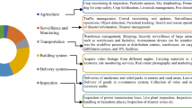
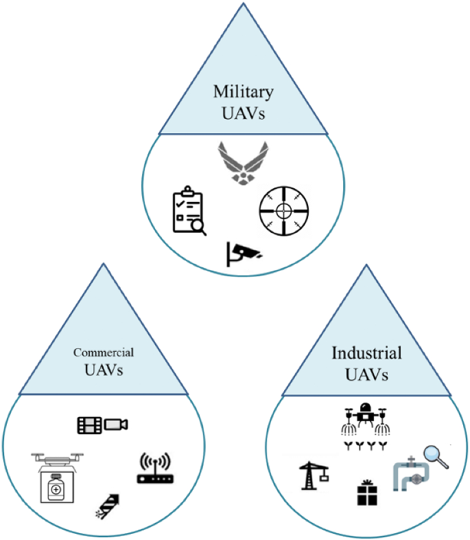
At present, UAVs are being used in multiple military, industrial and commercial applications [2], as shown in Fig. 1. In the military, UAVs offer navigation, secure communication and reconnaissance. Furthermore, they are being used in mobile edge computing, cellular communication, package delivery, smart healthcare, intelligent transportation systems, video surveillance missions, precision agriculture, power-line inspection, remote sensing, search and rescue, and performing relief operations in disaster environments [3]. UAVs have the capability to access remote or dangerous areas, facilitate environmental monitoring and capture high-resolution imagery [4]. These flying objects are helpful in monitoring as they bridge the constraints in limited-access, dynamic, harsh and complex environments. Furthermore, they reduce the labor and time required to survey, inspect and sample on ground, provide collision avoidance and quick convergence to reach targets, and offer more time for intended managerial operations. However, there are multiple critical limits on the design, deployment and performance of UAVs. Some of them have limited flight time, limited autonomy, less mobility and limited battery endurance. Harsh weather conditions and environments also impose limitations of UAV performance. Limited mission time is due to low battery endurance, harsh atmospheric conditions and sensor accuracy challenges. Several promising solutions are presented in the literature to mitigate these challenges, including high-quality devices such as manufacturing materials and motors, UAV geometry, wings and batteries. Some studies also address optimization strategies to look for shortest trajectory for UAV flight to reach the target destination [5].
1.1 Scope and contributions
This review is devoted to UAV technology and will help readers understand ongoing research and development activities. Our goal is to support readers in getting an overview of UAV types, swarms, configurations, standardizations and charging techniques, etc. We provide a comprehensive review of UAV challenges and security issues. We also provide realistic recommendations and solutions to overcome these challenges. We carry out our extensive analysis to empower the use of UAVs in several application scenarios. In the end, we discuss future research directions to further hone the research work dedicated to this promising technology.
1.2 Organization of the paper
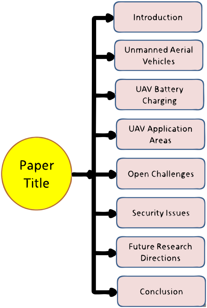
We have structured this study as follows: Sect. 2 reviews the research contributions on UAVs, types, classifications, payload, flight time, swarms and standardizations. Section 3 presents UAV battery charging techniques. Section 4 briefly discusses the UAV application areas. We examine open challenges in Sect. 5, while security issues and mitigating solutions are addressed in Sect. 6. We also present future research directions in Sect. 7. Finally, this paper is concluded in Sect. 8. The organization of this review can be seen in Fig. 2.
2 Unmanned aerial vehicles (UAVs)
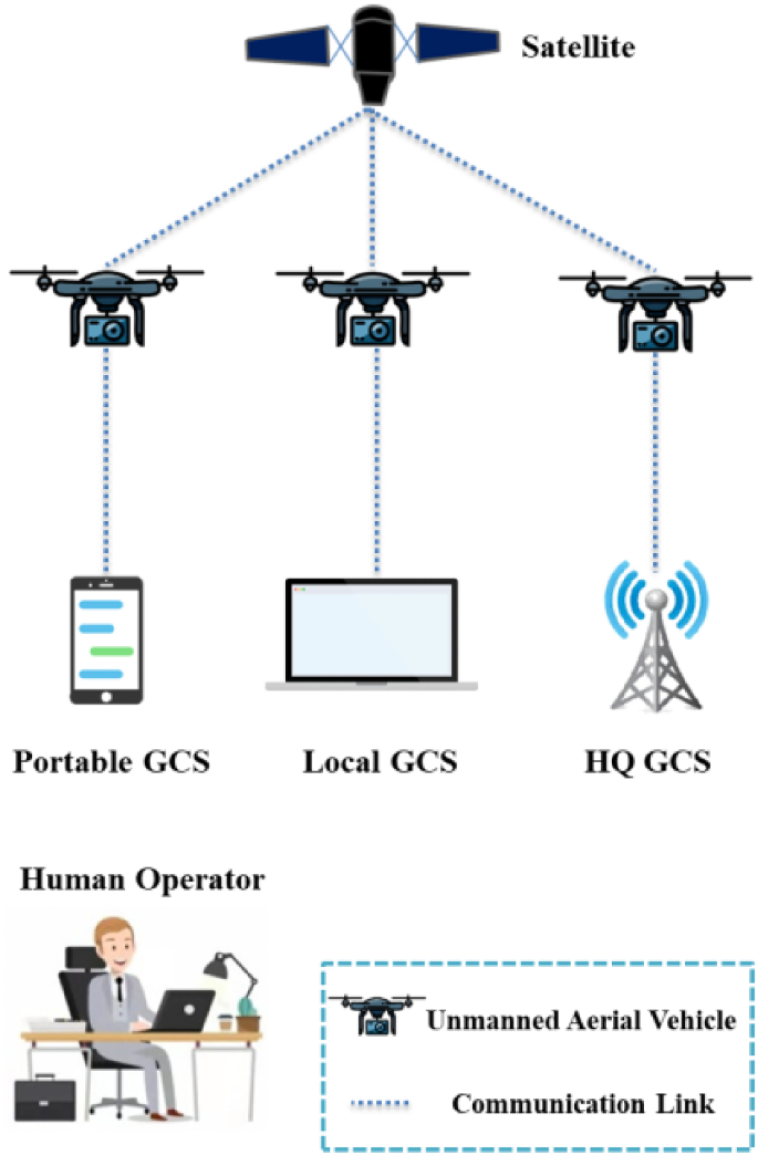
UAVs refer to controlled aerial vehicles, which perform several missions without human assistance. They can be remotely operated through different electronic gadgets such as microprocessors and sensors [6]. UAVs can perform operations autonomously in such areas where human intervention is dangerous [7]. Figure 3 presents a general architecture of UAVs where they utilize communication links to establish connectivity with satellite or ground control system (GCS) such as a laptop or smart phone. A human operator is needed to operate and control the UAV remotely. In literature, several works have been presented to address different features of UAVs. For instance, Zhang et al. [8] have focused on mobile charging features for drones to enhance their battery life. Aldhaher et al. [9] the use of a wirelessly powered receiver in order to decrease the weight of UAVs. Several wireless charging techniques have been suggested in [10] to increase the UAV’s flight time. Raciti et al. [11] reported a charging system empowered by a wireless power transfer (WPT) system. This study also highlights misalignment losses and associated mitigation solutions. Rohan et al. [12], proposed an intelligent drone charging system empowered by WPT. Shin et al. [13] addressed charge scheduling for multi-drones networks based on deep learning algorithms. In Table 1, we have summarized different surveys and reviews reporting on multiple aspects of UAVs.
2.1 Classification of UAVs
UAVs come in a variety of specs, equipment, sizes, ranges, and forms. Different types of UAVs can be found in the literature: fixed-wing, single rotor, fixed-wing hybrid, and multirotor [31]. Fixed-wing UAVs contain a main body, wings, propeller and motor. These UAVs need special training to control and they remain useless for aerial surveillance. A fixed-wing UAV is depicted in Fig. 4a [32]. These unmanned aerial vehicles are often used for aerial mapping and power line inspection. Such UAVs are not capable of hovering or forward flight. Figure 4b depicts a hybrid fixed-wing UAV [33]. Figure 4c depicts a single-rotor UAV [34]. However, single-rotor UAVs are costly to produce and need skill training. These unmanned aerial vehicles are mechanically difficult and susceptible to obstacles such as vibrations. Furthermore, multirotor UAVs are the most affordable and simple to build. These unmanned aerial vehicles are often employed for image and video surveillance. Quadcopters are the most often utilized UAVs, as seen in Fig. 4d. Quadcopters have gained popularity for their vertical landing, or quick maneuverability, low cost, and compact size. We have illustrated basic UAV types in Table 2. While Table 3 provides a comparison of different UAVs considering various characteristics.
2.2 UAV swarms
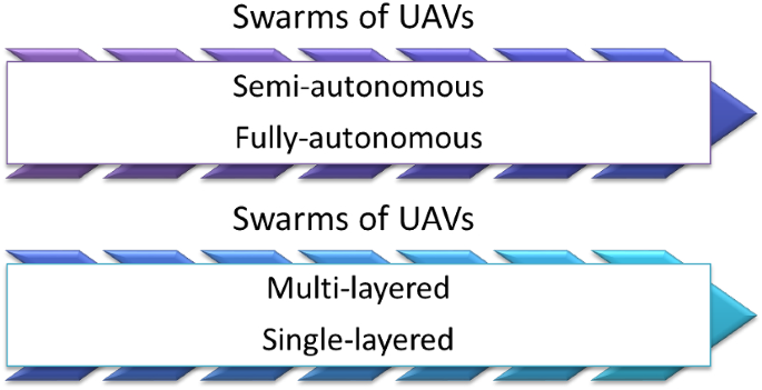
Figure 5 depicts the classification of UAV swarms as partly and completely autonomous. This categorization is also divided into single and multi-layered swarms. Each drone in the swarm provides real-time data recording and processing capabilities. While core processing takes place in the base station (BS) or in the clouds. UAV swarms with sophisticated monitoring mechanisms can cover a zone reliably and quickly by deploying several parallel-operating drones. Numerous studies have been reported on the usefulness of UAV swarms. Such as [35] analyzes swarms of drones to solve the charging process of many drones at the same time. It employs UAV swarms for smart power management. When considering the mission accomplishment of swarms of UAVs such as quadcopters, UAV flight coordination and hovering endurance become critical. Furthermore, the communication efficiency of the quadcopter swarm is critical for a successful operation. The authors devised a multi-robot coordination strategy in [36] to address the challenges of real-time synchronization of UAV swarms across a broad area network. Other investigations have looked at swarms of UAVs in the context of surveillance. [37], for example, describes quadcopter swarms for object location and tracking operations. Similarly, Leonard et al. [38] suggested tracking and detection algorithms for a quadcopter swarm-based monitoring program.
2.3 Developments in Navigation of UAVs
Navigation has a strong impact on UAV flight control. Several navigation technologies, such as Droppler, integrated, geometric, satellite and inertial navigation, perform multiple functions. The key navigation systems for UAVs are high-altitude, long-endurance navigation systems and tactical or medium range navigation systems. We can evaluate the development in navigation as follows:
-
High-performance navigation with data fusion: it plays a key role to determine the flight status to guarantee the normal UAV flight.
-
New inertial navigation system: it simplifies the volume and weight and takes less energy to refine the flight pliability.
-
Intelligent navigation system ability: information technology is used to enhance the UAV technology, along with updating the navigation system.
2.4 Formation control design
Motion control employee’s communication architecture needed for flow of information. Formation control strategies are as follows:
-
Leader–follower strategy: the main advantages of this technology are that it can be accomplished easily and simply. Owing to the leader dependency, it confronts single-point failures. The limitations of this strategy could be addressed by assigning virtual and multi-leaders.
-
Behavior-based strategy: the key benefit of this strategy is that it is greatly adaptable to even some unknown environments. However, it requires to be modeled mathematically which creates problems in analyzing stability of the system.
-
Virtual structure strategy: this strategy considers rigid structures for intended geometry or shape of the set of UAVs. The method fails to detect the faulty information in a UAV. The method also calls for a strong capability for computation.
2.5 UAV characteristics
2.5.1 Speed and flight time
Small-sized UAVs mostly fly at a speed of 15 m/s or below. On the other hand, large-sized UAVs can travel at higher speeds up to 100 m/s. Whenever any UAV is following any intended path to improve its energy or spectral efficiency, its speed should be taken into account at multiple turning points and locations along this path. In [38], authors have addressed this trade-off between UAV speed and turning agility.
Similarly, flight time indicates to the maximum time for which the UAV can fly until the batteries are drained out. It is of paramount significance along with cost. UAV weight, size and atmospheric conditions such as rain or wind have strong impact on battery endurance of UAVs which is closely associated to flight time. GPS and autopilot systems also play a crucial role in flight time. Small size UAVs can fly up to 20–30 min, while large size UAVs can fly up to several hours.
2.5.2 Payload
The lifting capability of a UAV to carry any weight is referred to as payload. Lifting capacity ranges from a few grams to several hundred kilos. Greater payloads allow for more accessories to be carried at the expense of shorter flying times, greater power capacity, and wider dimensions. Sensors and video cameras are common payloads for reconnaissance, surveillance, and commercial purposes. Cellular user equipment (UEs), such as tablets, mobile phones, and tablets weighing less than one kilogram, may also be carried by UAVs [39]. UAVs with high payloads are thought to have shorter flight duration. However, if a UAV has a larger surface area along with occupying more motors; it has the ability to store more power, which increases flying time. As a result, the payload's quality might let it move faster while maintaining the same precision and resolution. In Table 4, we have illustrated payload capability of different UAVs.
2.5.3 Sensing equipment
Radiation detection has already been discussed in ground penetrating radar, and hyper-spectral cameras to Synthetic-Aperture Radar. The author identifies highly sensitive light sensors in the field of precision agriculture:
-
Fluorescence excitation
-
Infrared spectrum imaging, and
-
Visible spectrum imaging
The particular sensing arrays are highly precise but the specialized equipment is highly expensive with limited versatility. Table 5 presents an overview of some sensing devices in UAVs. While Table 6 provides comparison of different imaging and ranging sensors considering various parameters.
2.5.4 Software
UAVs are significantly capable of playing roles in data processing tasks and problem solving. Several algorithms are used for optimization, autonomy and path planning. These tools can minimize human assistance and the infrastructure required for various tasks, such as communication. It is challenging to figure out suitable off-the-shelf software, which requires time and resources. However, researchers are on the way to developing novel methods and algorithms to address a variety of such problems. A geometric correction algorithm can be employed to decrease image distortion. Image processing algorithms are used for remote sensing or to process images captured from UAV cameras. Similarly, an offline path planning tool can be employed for UAV- swarm aided persistent surveillance methods and a self-adapting multi-featured evolution approach offering trajectory planning for UAVs.
The software installed in UAVs has been validated as an essential factor in value creation. This concept has paralleled the expansion of industries and companies devoted to software development. Among these companies are Skyworks Aerial System (USA), SkyWards (USA), RedBird (France), PIX4D (Switzerland), MapBox (USA), DroneDeploy (USA), Dedrone (Germany), and Airware (USA). Most of these countries are from European countries and USA, outlining the emerging industry of this transformative technology. Some of these companies focus on processing and analysis through captured images through UAVs, using their results to various industries such as construction, surveying, agriculture and mining, etc. While others operate as flying simulators (Redbird) and developers of UAV detection (Dedrone).
2.5.5 Range and altitude
The range of a UAV relates to the area it can be operated remotely from. Small drones have a range of a few meters, whereas bigger drones have a range of hundreds of kilometers. In contrast, altitude points to the maximum height at which a drone may fly. Aerial platforms are usually split into two groups based on their altitude.
Low-altitude platforms (LAPs): LAPs are typically used to facilitate cellular connectivity since they are quick to deploy and inexpensive. LAPs also provide a line-of-sight route, which can boost communication performance greatly [49].
High-altitude platforms (HAPs): high-altitude platforms (HAPs), including balloons, are also employed for cellular communication. When compared to LAPs, HAPs provide more coverage. The implementation of HAPs is complex, and they are mostly used to facilitate Internet connectivity. Table 7 shows the various kinds of UAVs based on their altitude. Table 8 provides a comparison of several types of UAVs. Figures 6a–d depict several UAV programs in various countries.
Different examples of UAVs on altitude a LADP, b LALE, c MALE, and d HALE [51]
2.5.6 Controllers of UAVs
Controllers are responsible for executing specific tasks for UAVs. They are defined as a series of actions that can affect UAVs and the physical world. The controllers vary according to the UAV type such as flapping wing, single rotor, multirotor and fixed-wing. These UAVs are designed for certain operations and face different aerodynamics. UAV control encompasses an extensive range of technologies and treatments. For some certain operations, the control may contain the macro- executions (such as formation control and path planning) and the micro flight control decisions of the actuators according to the provided commands. Due to the dynamic behavior of UAV configurations, the design and development of UAV control must follow an appropriate mechanism. As a result of the external disturbances, the operability of the flight control system is critical to following the stable response. The key objective of the controller is to reduce the error between the estimated and desired states, which can be altitude, velocity, or position of the UAV operating under varying atmospheric conditions. Next, we discussed the flight controller for UAVs in detail.
2.5.7 Flight controllers
Flight controllers are commonly known as autopilot systems, are the main elements of UAVs. They are generally designed to ensure autonomous flight control, such as mission planning, flight waypoint generation and attitude stabilization. To efficiently realize these operations, flight controllers require software or hardware assistance concurrently. The latter mostly consists of power control modules, communication entities, GPS modules, onboard sensors, inertial measurement units and onboard computers, and the former mainly contains signal processing algorithms, attitude control, path planning and task allocation.
The flight controller is based on three major components. The first one is named "kernel control law," which is responsible for the asymptotic stability of the UAV’s mobility within the air. The second component is called the command generator, which is used to generate references for the kernel control. The last part is the flight schedule, which is responsible for generating a group of flight arrangements to realize the desired mission. Flight control of a UAV can be achieved by controlling the altitude in order to maintain the UAV at the desired height and controlling the orientation and velocity to follow specific trajectories. Different linear and non-linear controllers are used for UAVs. The linear controllers include H¥, LRQ, PD, and PID, and non-linear controllers include NDI, gain-scheduling, fuzzy logic control, nested saturation, sliding mode, and backstepping. The linear controllers are as follows:
-
The H¥ Loop-Forming technique, which integrates conventional loop forming control with robust control, provides high robustness than other techniques. However, it is not feasible for large-scale UAV control.
-
A linear quadratic regulator (LQR) controller is an optimal controller which operates in dynamic systems with quadratic costs. It is regarded robust concerning technique uncertainty with a viable stability margin to error. However, it is not feasible always as it needs the full state of the system.
-
A proportional–integral–derivative (PID) controller is the most commonly used controller in UAVs. They are very popular due to their ease of use. However, they also impose limitation in optimality and robustness.
Nonlinear controllers are required to tackle with coupling components and non-linearity of UAV state variables. Nonlinear controllers are as follows:
-
Robust Control Algorithms are utilized to realize the effective behavior of the controller within an acceptable disturbance ratio. It can measure the performance changes with respect to the changing system parameters. It is feasible approach as it needs only the information about the limit in uncertainty.
-
The Backstepping Controller is a recursive design process which divides the controller task into various steps to ensure gradual stability in each sub-system. It can tackle external uncertainty and utilize less computational resources.
-
The Sliding Mode Controller (SMC) follows Lyapunov stability principles to force system state trajectory through a discontinuous control signal. It is inherently robust to any changes in parametric uncertainty, external disturbances and modeling errors. It is very feasible to analyze the second order dynamic systems. Table 9 provides a comparison of different flight controller.
2.6 UAV standardizationsp
2.6.1 UAVs 3GPP standardization
In this technological era, UAVs have gotten a lot of attention in the line-of-sight (LoS) and non-line-of-sight (NLoS) environments [56]. The third generation partnership group (3GPP) completed numerous investigations in 2017 and produced Release-15 to recognize long-term evolution (LTE)-powered UAVs. The key objective of this research was to concentrate on UAV traffic demands, channel modeling methodologies for air-to-ground dissemination views, reuse of existing cellular networks to facilitate LTE support, UAV communication, and innovations necessary to incorporate LTE into UAVs. The 3GPP's goals also include determining which traffic categories require current cellular networks to accommodate UAVs flying more than 300 m above the ground. Table 10 highlights the following UAV communication needs: (i) synchronization and radio control; (ii) command and control; and (iii) application data [18].
2.6.2 UAVs standardization outside the 3GPP
Aside from 3GPP standardization, numerous additional regulatory bodies have specified distinct UAV requirements to assure effective, consistent, and standardized communication.
-
The Institute of Electrical and Electronics Engineers (IEEE) established the Drones Working Group (DWG) in 2015. The primary goal of this group was to create a taxonomy for consumer drones in order to emphasize privacy and security issues. In order to do this, the DWG creates techniques, systems, specifications, testing, and evaluations for consumer drones to protect the privacy and security of the public and their properties. Similarly, the IEEE Conformity Assessment Program (ICAP) and OM/AerCom SC are collaboratively designing a conformity assessment program such that UAV approaches can show conformance with IEEE standardizations. The IEEE drone application certificate program is also introduced which is comprised of industry stakeholders, that will support regulators, system integrators, solution providers, manufacturers, users and other potential beneficiaries. It also includes the academic community and test laborite to demonstrate to buyers that UAV systems or products conform to IEEE standardizations.
-
The European Telecommunications Standards Institute (ETSI) investigates UAV operations, use cases, and knowledge of the to-be-built Internet Protocol (IP) suite framework, as well as the spectrum rules required to accommodate UAVs in current LTE networks [57]. ETSI has also developed European standards under EC regulation requests to ensure the extensive use of services such as Data Link Services (DLS), Advanced Surface Movement Guidance and Control along with Airport Collaborative Decision Making procedure. Furthermore, Radio Equipment Directive has been developed to employ on UAVs operating in conformity with the spectrum management. ETSI can also be utilized to show compliance with certain aspects of the directive.
-
The International Telecommunication Union (ITU-T) made work item (WI) Y.UAV.arch so that unmanned aerial vehicles (UAVs) and unmanned aerial vehicle controllers (UAVs) can have a stable and functional architecture over IMT-2020 networks [58]. IMT-2020 is employed for UAV communication. As UAVs need simultaneous applications with different aspects, thus a new kind of user terminal to IMT-2020 is needed. Likewise, the novel communication network IMT-2020 is designed for ground coverage of UAVs. A group of functionalities is required to fill the gap for interoperability between IMT-202 networks and UAVs in order to improve the quality of UAV operations and implement the feature of civilian UAV operations in IMT-2020. This recommendation supports an operational architecture for UAV operators through IMT-2020 networks and functionalities defined in the physical layer, application layer, and application support layer.
-
Federal aviation authority (FAA) is responsible for civil aircraft operations in national airspace (NAS) in the USA. It aims to provide operational and regulatory framework for unmanned traffic management (UTM). It interacts with UTM for data or information exchange. In March 2020, FAA released an updated UTM concept in order to define the technical and operational requirements for UTM ecosystem to ensure the operations of unmanned airspace systems in all existing airspaces. FAA has also set a limit of weight less than 55 pounds to include as small UAS. In general, FAA divides the existing airspace in six classes A to G. G refers to uncontrolled while class A-G is for controlled airspace. It means class G will not be monitored by air traffic control will be overseen by ATC entities. According to FAA rules, UTM operation can be performed till 400ft above ground. In case of uncontrolled airspace, the remote pilots are exempted to get approval from authorized training center (ATC) authorities. However, while entering into controlled airspace, they must inform ATC about their intent. Moreover, the UAV operator should guarantee that the foreseen UTM operations are compliant with the certain rules, e.g., e-registration of both operator and UAV and must satisfy safety requirements including communication abilities and drone airworthiness [59].
-
European Aviation Safety Agency (EASA) has also implemented regulations to operate UAVs. The EASA concepts are based on a regulatory framework considering operation-centric and proportional strategy which addresses conditions and the way of the operation rather than just focusing on UAV parameters. These actions are guided and accompanied by the European Roadmap to integrate civil remotely-piloted aircraft into the European Aviation System. The document identified several levels of integration and harmonization. It also contains three annexes with a clear strategy to implement and improve regulations, foreseeable research initiatives and societal impacts on UAV services. The major difference between proposed concepts is the application of three EASA drone categories such as OPEN, SPECIFIC and CERTIFIED [59]. Thus, UAV operations performed under both SPECIFIC and CERTIFIED must be authorized by the national aviation authorization (NAA). This authorization will allow UAV operations with high risk levels such as flying over populated area. Consequently, specific system capabilities and operational requirements must be satisfied by the operator to perform these operations.
2.7 UAV docking station: preliminary description
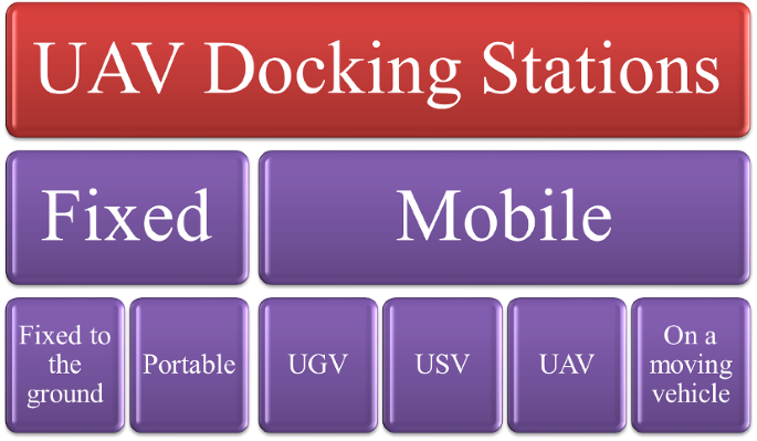
Docking stations are multipurpose to facilitate safe landing, recharge, or take off, payload and data transfer. Some docking systems are capable of storing UAVs safely, protecting them from harsh environmental conditions. Docking stations can be categorized regarding [1]:
-
Mobility
-
Charging method
-
Automatic battery exchange
-
Positioning
-
Drone storage
-
Package delivery
-
Landing type
-
Landing platform type
Docking station comprises multiple subsystems, for example, power supply, a landing platform, battery recharging setup, drone storage system and many more. Docking stations should satisfy specific criteria to meet their goals. The classification of UAV docking stations is illustrated in Fig. 7. We have summarized some commercially available docking stations in Table 11. In next section, we will comprehensively discuss the UAV charging techniques.
Classification of UAV docking stations [1]
3 UAV battery charging
One major issue in UAV performance is limited battery capacity. It is not suggested to increase battery weight or size as ultimately it will enhance payload which is another crucial issue. Charging can be obtained through wired or wireless power transfer (WPT) system [65] as discussed below:
3.1 Wireless power tranfer (WPT)
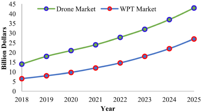
According to an analysis [66], the estimated revenue of WPT is around $2000 million till 2020. Figure 8 provides the estimated growth market for WPT and drones till 2025. It is envisaged that total sales with a Compound Annual Growth Rate (CARG) of 13.8% by 2025 will hit $43 billion [67]. This extensive growth is due to several applications in electronic industry with multiple advantages in terms of autonomy, reliability, convenience, security and safety. All these advantages can be obtained using various WPT techniques. One key benefit of using WPT techniques is the operability in those environments where wired medium power transfer is impossible or dangerous. WPT techniques are organized as radiative electromagnetic (EM) and non-EM techniques. In non-EM, power is transferred through optical or acoustic sources. In EM techniques; resonance coupling, magnetic coupling, inductive coupling and capacitive coupling are used. At present, these WPT technologies are commercially used for several applications such as implantable medical devices, smart phones and UAVs etc.
Statistics of WPT and Drones market growth [68]
WPT techniques offer reliable and efficient power transmission for UAVs. However, WPT techniques for charging UAVs must consider critical limitations under payload, interference, harsh weather conditions and misalignment. Among these critical factors, misalignment is a dominant challenge as UAVs mostly suffer from landing accuracy issues. UAV-empowered WPT techniques must be lightweight. These techniques should ensure efficient charging and high precision landing along with tolerance to misalignment factor. Several research works have been carried out for UAV charging through different WPT techniques [69, 70]. We have summarized some of these studies addressing UAV-based WPT systems in Table 12.
3.1.1 Photovoltaic (PV) cell-based UAV charging
The PV cells are used to charge batteries by using sunlight and they can significantly enhance the flight time of UAVs. In the presence of sunlight, the PV cells provide the required power to UAVs. However, in the absence of sunlight, the required power is delivered through batteries. Several research studies have been reported on solar-powered UAVs [79, 80]. According to Fazelpour et al. [79], various parameters play a major role in solar-powered energy transfer such as type of PV cell, position, orientation, geometry, temperature intensity, weather conditions and angle of incidence of sun. However, this technique is critically limited in the absence of sunlight. Atmospheric conditions such as clouds, fog, rain, temperature, humidity can substantially reduce the UAV’s efficiency and reliability. Thus, it is suggested to investigate alternative solutions to continue the UAV mission under such scenarios. Controlling PV cell position based on incident sunlight, increasing PV cell size or UAV batteries, and carrying additional power supplies are some of these strategies.
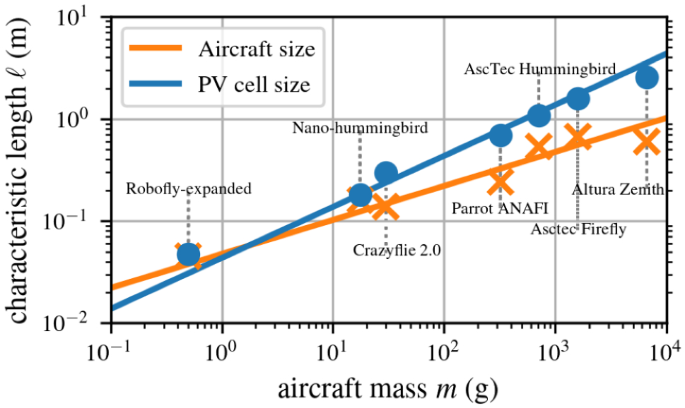
Currently, different types of PV cells are available to ensure high-efficiency and cost-effectiveness. Some studies have focused on mono-crystalline silicon PV cells as they support high flexibility and easy integration with UAV wings [81]. Research fraternity is still looking for novel designs and energy management strategies with enhanced efficiency, high availability and reliability. There is a need to focus on research activities in material perspective as low-efficiency of these PV cells is a major limit [82]. In [83], authors proposed optimization approach for solar-powered UAV trajectory in order to attain high solar radiation at low usage of mechanical energy. In [84], authors reported that solar power may be beneficial for small size aircraft. They plotted a graph as shown in Fig. 9 considering PV cell size, drone size and mass for a continuous hovering flight. To plot this graph, authors assumed 30% efficient cells, 1/3 sunlight and drones capable of sensor-autonomous hovering. Table 13 shows the PV cell size required for persistent solar-powered hovering for different UAVs.
PV-powered hovering favors small aircraft [84]
Solar-powered UAVs have gained significant attention in both academia and industrial sectors. Several research and industrial activities have been initiated on solar-powered UAVs. Figure 10 shows solar-powered drones projects by technology giants e.g., Google and Facebook. Google started using these UAVs to provide internet access in remote areas. At present, such UAVs are being used for forest fire fighting, internet coverage, high-altitude communication, border monitoring, and power-line inspection.
Solar-powered drones a Google’s project, b Facebook’s project [92]
3.1.2 Charging with laser beaming
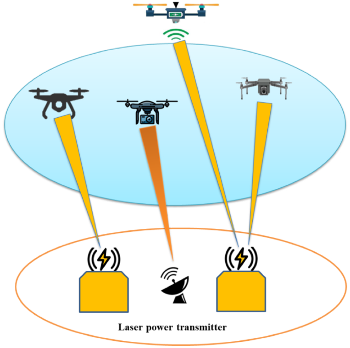
Laser power transfer (LPT) is another promising charging technique, which is commonly used in space and military missions [93]. In this charging method, laser diodes of different wavelengths are used to deliver power to PV cells integrated on UAVs. These PV cells harvest energy from laser beams to charge batteries or deliver the required power to UAVs. This charging technique is mostly used for fixed wing and rotary wing UAVs. Laser power transfer is considered a promising approach to ensure unlimited endurance. It can deliver high energy to support various energy-hungry remote operations of UAVs [94]. Several studies have been reported on LPT techniques [95, 96]. In [96], the authors introduced a controller design mechanism considering laser PV module to adjust the power conversion of LPT system. In another reported work [97], the authors discussed results pertaining to voltage, current and efficiency considering a LPT system. Furthermore, author in [98] carried out analysis of wavelength and temperature output of PV cells in a laser-based charging system. In [99], authors discussed UAV-based missions for longer durations considering different techniques. Authors discussed laser charging based on low-power laser source and precise energy consumption for UAV along with investigating its dynamics in a mission environment. In another reported study [100], authors investigated the joint problem of trajectory and power optimization in a rotary-wing UAV-empowered mobile relaying network. In order to support sustainable and convenient energy supply, they considered wireless charging of UAV through a power beacon and properly realized through a laser charging system. Apart from different advantages of LPT systems, there are several critical issues such as mobility, blockage and limited performance on long-distance flight. Moreover, this system is not feasible in airports and military areas where laser beam usage can be harmful. In Fig. 11, we present a LPT system to charge multi-UAVs.
4 UAV application areas
The ongoing activities on UAV deployment have created a new breed of promising applications to carry out autonomous missions. This section highlights several prominent application areas of UAVs.
4.1 Disaster management
UAVs can visit disaster regions that are unsafe for manned action in the event of a man-made or environmental catastrophe, such as terrorist strikes, tsunamis, and flooding. Power, telecommunications infrastructure, water utilities, and transportation are all vulnerable to these calamities. UAVs can assist in the collection of data, the need for quick answers, and the navigation of debris. UAVs equipped with sensors, radars, and high-resolution cameras can aid rescue teams in identifying damage, launching urgent recovery efforts, and dispatching supplies including first-aid manned helicopters and medical kits. UAVs can aid with catastrophe assessment, disaster alarms, and discovering preventative measures in real-time. A swarm of drones equipped with firefighting equipment can watch, analyze, and track any region in the event of a wildfire without jeopardizing human life. As a result, UAVs may help with real-time surveillance of a vast region without jeopardizing the safety and security of anyone involved. Unmanned aerial vehicles (UAVs) can help to find people and animals in danger so they can be saved.
4.2 Remote sensing
Drone technology is increasingly being applied by amateurs to collect high-resolution imaging data of isolated places, such as mountaintops, coastlines, and islands. The usage of UAVs serves as a link between aerial, ground-based and space-borne remotely sensed data. UAVs' cost-effectiveness and ultralight features enable spatial and temporal resolution observation. Disease diagnosis, water quality inspection, famine monitoring, gas and oil yield estimations, conservation of natural resources, geological calamity survey, topographical survey, woodland mapping, hydrological modeling, and crop management are all possible applications of UAV remotely sensed. Poor water quality because of wastewater discharge and nutrient pollution is a critical concern in some marine and coastal environments. Particularly, nutrient flow from agricultural, urban, and industrial activities can cause harmful algal blooms (HABs), ultimately producing the harmful toxins. Some research labs in Virginia and Florida, USA are focusing on the use of UAVs to early trace and detect HABs through hyperspectral sensors. However, there are several challenges which must be tackled to make this technology practical for coastal monitoring activities. Moreover, this technique is also being utilized in archaeological and cartography for crowd-sourced mapping and the generation of 3D atmospheric maps. Drones may deliver current data at low cost, allowing land planners to avoid depending on obsolete mapping sources.
4.3 Search and rescue (SAR)
Unmanned aerial vehicles (UAVs) are considered critical in areas like disaster risk management, rescue missions, and public security. UAVs may save a lot of time and resources by providing real-time imaging data of desired sites. Resulting that, the SAR group is able to detect and pinpoint precisely where aid is necessary. Drones, for example, can be used to follow lost mountaineers on any trip or to defend humans in any isolated forest or desert. Drones may therefore aid in the tracking of unlucky victims as well as any difficult terrain or harsh weather conditions. Drones can deliver critical medical equipment before an emergency or physician arrives. Drones containing food supplies and medical supplies such as vaccines, medical kits and life-saving jackets can be sent to disaster-stricken communities and isolated locations. Drones, for example, can deliver clothing, water, and other essentials to stranded people in difficult regions before rescue workers arrive. This technology can help speed up SAR efforts in disasters such as mission personnel, avalanches, forest fires, and deadly gas penetration.
4.4 Infrastructure and construction inspection
UAVs have made as-built maps, project monitoring, and surveys more efficient, simple, and quick. Tracking the development of the building project from start to finish ensures that the work on the site is of high quality. It may deliver reports to prospective stakeholders that include pictures, video, and 3D mapping. Infrastructure and construction inspection applications can benefit greatly from this approach. UAVs are gaining high popularity for evaluating the global system for mobile communication (GSM) towers, keeping an eye on gas pipelines, inspecting power cables, and keeping an eye on building projects [101].
4.5 Precision agriculture
UAVs could be installed in smart agriculture to obtain specific information through ground sensors (quality of water, soil composition, humidity, and so on), spray pesticides, diagnose illness, schedule irrigation, detect weeds, and monitor and manage crops. The applicability of UAVs in precision agriculture is a cost-effective and time-saving strategy that can improve agricultural systems' revenue, performance, and agricultural production. Furthermore, UAVs aid in insect damage, weed monitoring, chemical spraying, and farm management, resulting in higher crop yields to handle these difficulties quickly. UAVs combined with remote sensing have the potential to revolutionize smart farming. It offers temporal, geographical, and spectral resolution, as well as multi-angular observation and comprehensive vegetation height data. By undertaking sophisticated aerial mapping, UAVs can have a huge influence on the agricultural system. UAVs outfitted with the necessary cameras and sensors can analyze crop health status, including leaf area, foreign pollutants, chlorophyll content, and temperatures [102]. WH Maes et al. evaluated the advancement of remote sensing through drones in growth vigor evaluation, nutritional status, disease and weed identification, and drought stress [103]. With more UAV photos, digital image methods will be able to study plant diseases and other things in the future.
4.6 Real-time monitoring of road traffic
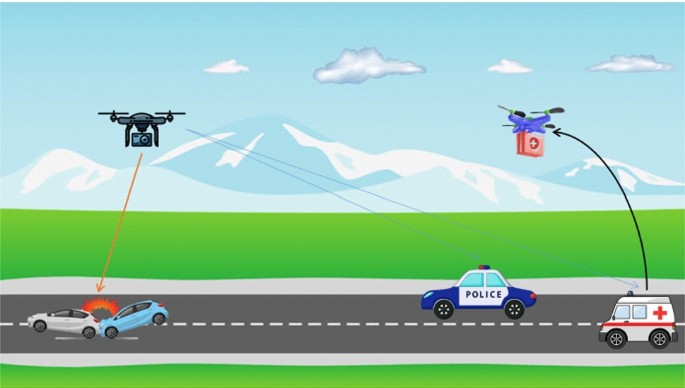
The integration of UAVs with road traffic monitoring (RTM) systems has piqued the curiosity of many. UAVs can accomplish 100% automation of the transportation industry in RTM [104]. Rescue squads, roadway surveyors, traffic cops, and field support personnel will all be automated. Reliable and intelligent UAVs can support with the automation of these parts. UAVs have emerged as a new viable instrument for gathering data on highway traffic situations. As compared to traditional monitoring systems e.g., surveillance cameras, ultrasonic sensors, and circuit analyzers, low-cost UAVs, or drones, can inspect large sections of road [101]. Local police can use drones to gain a clear picture of road accidents or to conduct a large security crackdown on illegal activities along the highway, including car theft. Some of the other implications include vehicle recognition; raids on suspect cars; pursuing hijackers and armed robbers, or anybody who breaches traffic regulations. It may also be used to monitor driving and incidents in vehicles and probably prevent traffic bottlenecks and overcrowding [105]. Figure 12 depicts an overview of UAV service on the roadway.
Likewise, UAVs may be used to monitor road conditions, such as detecting fractures and providing early warning to avert traffic accidents and reduce damage. At present, road inspection and monitoring are carried out using human vehicles, and the level of automation must be increased. The combination of road inspection technologies with UAVs has the potential to drastically minimize road damage. UAVs can take pictures of road cracks and use target detection algorithms to figure out what they are.
4.7 UAVs for automated forest restoration
One more developing study area is the use of UAVs for controlled forest restoration (AFR). UAVs could be used to aid in the accomplishment of re-vegetation activities e.g., site infrastructure, site inspection, restoration plan, seedling supply, site maintenance (germinating and weeding, for example), and bio-diversity survey after restoring interventions [106]. Existing technology, such as GPS and image sensors, assists UAVs in performing specific tasks, such as fundamental pre-restoration site inspections and monitoring various aspects of biodiversity revival. UAVs could evaluate any alterations in temperature, forest functions, and ecological composition, hence assisting in the surveillance of replanting [107]. High-resolution cameras mounted on UAVs can give useful data on natural forests to aid in forest restoration initiatives. Because of their simplicity of data acquisition and mobility, UAV cameras with suitable resolution can aid in the characterization and study of forest landscapes. Likewise, optical sensors mounted on UAVs are being used to obtain geometric properties of forests, such as vegetation cover, diameter, and length [108]. UAVs can also be used for remote sensing, which is a reliable and effective way to monitor forests that is different from the way it has been done in the past.
4.8 UAVs for monitoring of overhead power lines
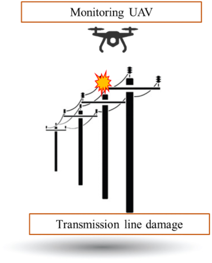
Power line fault detection and avoidance are critical for the reliability and quality of generation capacity. Traditional procedures have several disadvantages, including expensive costs, inconvenient deployment, and dangerous dangers. As a result, researchers are interested in UAV-based power line distribution and inspection, as illustrated in Fig. 13. The safety of a power transmission system is sometimes referred to as power line inspection. The use of a digital camera installed on UAV to photograph power line corridors is a practical way to perform inspection duties [109]. UAVs can also be installed to look for broken bolts, rust or corrosion, and lightning strikes on electrical pylons. Short-circuiting issue of electricity lines is most commonly caused by severe weather, bushfires, and tree falls. Authors of a recent research [110] examined the use of UAVs to detect and monitor defects in overhead transmission lines. To find defects, both climbing robots and flying UAVs can be utilized. These inspection tasks may be carried out by UAVs at a cheaper cost than helicopters and with a lower risk than traditional foot patrol. Fixed-wing UAVs, which can fly at high altitude and speed than other types of UAVs, are most commonly used for rough inspection. Multirotor UAVs, on the other hand, obtain photographs in the air at a closer distance from the objects by hovering. Because of their excellent 3D mobility, multirotor UAVs are ideal. Despite these advantages, autonomous mission planning and piloting of a multirotor UAV in a limited or complicated area is difficult. Advanced data collection, exchange, and processing tools for cooperative UAV networks should be researched in the future to provide reliable, efficient, and speedier inspections.
4.9 UAVs for monitoring and assessing plant stress
UAVs have become an integral element of data collection in multiple applications. The use of UAVs in agriculture is highly suitable in multiple scenarios. Currently, the use of UAVs is steadily expanding to monitor and assess crops, forests and orchards. They play a major role to manage plant stress such as pests, nutrition deficiencies, disease and water quality and quantity. Several studies have been reported on plant height assessment, canopy cover estimation, vegetation classification, biomass estimation, yield prediction and stress detection [111]. Every domain has certain aspects which must be kept into account to address the impact of UAV-enabled services. Among these domains, plant stress detection and quantification has received high attention.
Several UAV-based approached are being used to assess plant stress. However, there are several shortcomings which prevent their usage at a high-scale. For instance, the techniques based on thermal imagery are limited by negative impact from various factors including stomatal conductance patterns, canopy architecture, shadows and soil background. Similarly, methods based on hyperspectral and multispectral images suffer from spatial resolutions, angel of capture, illumination and canopy structure. Moreover, UAV-based red, green, and blue (RGB) images are only feasible in clear visibility scenarios. Although image-based techniques are useful for pesticide applications, irrigation practices, disease prediction and prevention and weather information, but they are not feasible yet, regardless of the deployment techniques and sensing devices. There is a need to develop sophisticated ML and computer vision techniques along with novel sensors for UAVs to overcome aforementioned limitations. At the same time, research fraternity should perform more experiments to study plant physiology and impact of various stresses on biological process. It will be an excellent opportunity to contribute in this domain and find viable solutions.
4.10 UAVs for space exploration
There is an emerging trend to utilize UAVs for planetary exploration from last few years. UAVs offer tremendous potentials to carry our space missions such as study about moon surface and atmosphere. Although several planetary exploration techniques are available to perform these missions including rovers, landers, orbiters, flying balloons, flying spacecraft, probes and telescopes [112]. However, these techniques are restricted by resolution, limited information and versatility. Therefore, UAVs have recently got focus due to several benefits in such missions. Several government bodies and space agencies including National Aeronautics and Space Administration (NASA) has started using UAVs to other solar bodies. Researchers have focused on solar exploration works through autonomous, semi-autonomous and UAVs. According to Sharma et al. [112], UAVs have good chances to fly in the atmosphere of Mars. It is due to the potential features of hovering, VTOL and low-speed forward flight. In particular, UAVs offer a wide coverage area as compared to exiting orbiters and rovers. As gravity is less at Mars surface and it has low density, so UAV can achieve an optimal height of 380 m. However, some challenges still exist in terms of efficiency and cost. Thus, there is a need to develop compatible propulsion system, suitable aerodynamic design, and optimal flight trajectories.
4.11 Aquaculture farm monitoring and management
UAVs have the ability to monitor fish farms in aquaculture, particularly on offshore sites. The mobility and affordability of UAVs ensures accessibility to remote areas. The automation and mechanization to monitor farms through UAVs, sensors and artificial intelligence (AI) approaches will support farmers to gather information about farms and interact efficiently. Moreover, due to the extensive advancements in aquaculture industry, UAVs can be used to achieve target results and effectively monitor the expanding farm sites. UAVs can significantly reduce cost and labors in the aquaculture industry, thus providing stability in fish form through minimizing farm deaths. In aquaculture, UAVs can be used to capture real-time images on underwater species, observing fish behavior, remote sensing, site surveillance, fish feeding management, and for assessment of the species [113].
UAVs offer enormous benefits for monitoring offshore kelp aquaculture farms. Giant kelps are effective aquaculture crops which needs regular monitoring in order to achieve maximum production, and optimizing biomass and nutritional content. For this purpose, a small UAV carrying a lightweight optical sensor can be used to monitor these farms. It can estimate the tissue nitrogen quantity, density and canopy area based on space and time scales, which plays significant role to observe any changes in kelps. UAVs with integrated sensors such as hyperspectral, multispectral and RGB cameras can be used to provide a natural image of kelp forest canopy. Similarly, UAVs can be used to observe and characterize the mobility of the pellets. Through collected information, farmers can attain feeding optimization.
4.12 UAVs in emergency medical services
UAVs have shown great potential in smart cities worldwide. Smart cities have smart healthcare system based on telemetry, implantable medical equipments, and medical drones to quickly deliver first-aid supplies. Currently, UAVs have proven their stature to tackle with COVID-19 pandemic in different countries. However, it is worth noting that the leading organization to tackle with COVID-19 is the national EMS institution along with several parties such as EMS personnel, nurses, and medical doctors. In addition, several policy makers are considering different preventive measure to fight against COVID-19 including wearing surgical masks, avoiding facial-touching, regular hand-washing, city lockdown, high risk area avoidance, social gathering avoidance and implementing health codes [114]. Policy makers should consider the balance between economy and public safety before introducing any new measures. Currently, UAVs are being used to perform various tasks to prevent COVID-19 such as:
-
Transport of patients
-
Public announcements
-
Crowd surveillance
-
Spraying disinfection
-
Mass screening
-
Crown aerial monitoring
-
Delivering vaccines and other medical supplies
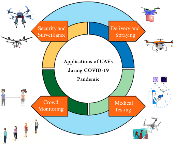
A very common application of UAVs is to supervise or monitor any specific area. UAV-integrated cameras can assist in real-time surveillance. Thermal cameras can be implemented to trace febrile patients. It helps to quickly implement isolation rules in any certain area in order to reduce the risk of further disease spread. Similarly, on-board loudspeaker can help to deliver official policies and give appropriate instructions in any community [115]. UAVs can help to deliver daily life items, ensuring reduction in mass contact at crowded markets or other public places. Furthermore, UAVs can support in transportation tasks such as medicament supply deliver and COVID test sampling collecting, ultimately reducing the risk of contact with infectious person and virus spread. UAVs can also play their role in nucleic acid testing, collecting samples and delivering reports. They can also be used to spray disinfection in order to mitigate the viability of the virus on the surface. In 2020, UAVs have been used during the COVID-19 crises to deliver medical supplies in USA, China, Chile etc. Recently, Zipline, working collaboratively with Novant-Health, has been providing COVID-19 vaccines in North Carolina, USA. UAVs have been used to provide personal protective equipment to frontline staff fighting against this pandemic. Different applications of UAVs to cope with COVID-19 are presented in Fig. 14.
4.13 UAVs for maritime communication and surveillance
Aerial platform include the use of high-altitude platform Stations (HAPS), flying up to 20 km from the ground and UAVs flying at a few hundred meters above the sea surface [116]. Some UAVs can be installed and remotely operated from small boats, while larger systems rely on onshore architectures to launch and operate. This technology is complementary to surface and underwater vehicles since it can be easily controlled in the air at some distance and altitude, and thus communicate at a different speed and position. In maritime networks, UAVs can assist to forward the data from ground station to mobile vessel even in the absence of LoS path. In addition, UAVs can relay data from IoT sensors located in ocean and relay data from/to USVs. The main limitation in the operation of UAVs is limited battery capacity and payload. This limitation can be relieved through a tethered UAVs connected with a power supply. However, it can pose another issue of limited mobility. There is a need to find optimal path to collect data from the sensor nodes in maritime environment. Some recent works have been reported on tethered UAVs fixed on buoys [117]. Tethered UAVs can hover at a limited range above the water surface with limited mobility and coverage. Also, optical fibers can be connected with tethered UAVs to ensure high transmission rates. However, HAPs are more suitable as they offer extended coverage. Moreover, HAPs can carry large antennas, removing less weight limitations and offering autonomy up to several months.
Due to enormous benefits of UAVs in maritime communication, UAV-to-ship wireless channels must be developed. Furthermore, efficient system testing must be conducted for the promising UAV-to-ship networks. In maritime environments, UAV communication faces different channel characteristics, including temperature of troposphere above the ocean, pressure, waveguide impact due to humidity, signal attenuation due to climate change and seawater irregular fluctuations. In contrast to terrestrial UAV-to-ground channels, the scatterers effect on UAV-to-Ship is uneven due to irregular sea waves. Similarly, waveguide propagation is another essential factor in UAV-to-ship channels, which ultimate introduces different channel characteristics. In order to ensure sophisticated UAV communication in such maritime environments, the related channel modeling is an open research area for future contributions. In US, both the coastal guard and Navy have deployed a group of small UAVs to assist manned assets, supporting in many aspects to support law enforcement, surveillance and military missions in marine and coastal environments. Moreover, two US-based systems ScanEagle and MQ-4C Triton are being used for naval missions. The former is deployed with radar as well as infrared (IR) and electro-optical (EO) sensors, making is capable to perform persistent maritime surveillance missions. It has the ability to identify ships through installed AIR receivers.
4.14 Flying cars and eVTOLs
Rapidly expanding high infrastructure costs, land space limitations and urban population put a critical challenge for the future ground-based transportation systems. Flying cars, no more confined to the realm of fiction, are a remarkable step in transportation industry. Flying cars and eVTOL (electric vertical take-off and landing) aircraft is envisaged to revolutionize the future transportation system, which can substantially minimize greenhouse gas emissions and carbon footprint of personal vehicles as well as travel time. Currently, over 250 companies have started initiatives on eVTOLs and flying cars, and few vehicles will pave their way to commercial market soon [118]. From last few decades, there has been a notable expansion in the use of personal vehicles worldwide, causing traffic congestion, a rapid climate change, and enhanced commuting duration, particularly in metropolitan areas. In this regard, eVTOLs and flying cars are expected to be the future of smart transportation system as they will support reduced emission and traffic congestion along with improving security. These disruptive technologies will have diverse requirements based on their application scenario. For example, personal vehicles should be economical, lightweight, and should contain fewer parking spaces, while piloted taxi services are envisaged to have range and speed according to their Rural Air Mobility (RAM) and Urban Air Mobility (UAM) missions.
Flying car manufacturers are finding innovative designs to shrink the vehicle size through detachable propellers or retractable wings for different tasks such as drive mode or garage parking. Several flight mechanisms and wing configuration are being proposed for the eVTOLs and flying cars to ensure forward flight for the cruise and vertical lift for both take-off and landing. At present, mostly available flying cars have hybrid energy supply system or only gasoline and do not have VTOL capabilities. However, ensuring a complete electric flying car is yet to be explored. In a recent study [118], authors discussed fully electric powertrain design with dual energy sources, such as hybrid fuel cells and batteries, to support extended range. Moreover, authors also discussed the use of a single propeller for both flight and drive modes in order to aid VTOL capability. Despite these technical advancements, initiating widespread deployment of flying cars will impose an immense standardization challenges and sustainability implications [119]. Despite these challenges, several companies have started innovative strategies to introduce these smart flying vehicles in future. With expanding features supporting timesaving, environment, and economic potentials, it’s time for regulatory bodies to make the life-changing leap to seed the architecture development for personal urban airspace utility. With these advancements in aviation regulations as well as processing and sensor technologies, we can expect a transition toward futuristic smart and automatic transportation systems.
5 Open challenges
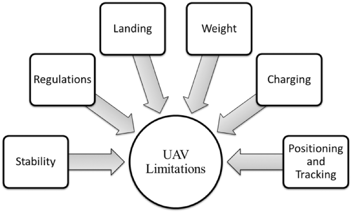
UAVs are prone to several critical challenges and limitations, which require future investigations. Some limitations in UAV usage are presented in Fig. 15 while potential challenges related to UAVs are as follow:
-
One of the critical challenge is to ensure the security of sensitive data such as position, location etc., from drones or UAVs. As there is no encryption on UAV, so there is risk to be hijacked. Hacking and cyber liability are critical issues of using UAVs. In military operations, UAVs are vulnerable to potential threats of data leakage. Hackers may usurp complete control of UAV to steal data, invasion of privacy and any illegal activity such as for smuggling.
-
Despite the extensive emergence of UAVs, there is a dire need to devise standardizations from regulatory bodies for the operations of UAVs in geographic area of different countries. A major hindrance in the widespread use of UAVs is the ambiguity or lack of significant standards and regulations for UAV operations, allowed airspace, allowed weight and size, allowed height, privacy or secrecy considerations, safety requirements and characteristics. A lack in heterogeneity of government rules for the implementation of UAVs can be observed. UAVs can affect the navigation of commercial airplanes. So countries should implement regulations and rules for proper operations of UAVs. For instance, in the US, the FAA is responsible to issue certificates and air traffic regulations for UAVs. Similarly, international collaboration or coordination can also assist to introduce global rules, as different countries have different regulations and standards. For example, at present, there are three different regions, such as (a) region 1 contains Africa, Europe and some part of Middle East, (b) region 2 contains US, and (c) region 3 is based on Asia and the Pacific, operating at different frequency ranges for UAV operations. In short, several concerns are associated to UAV regulations, such as poorly documented legal processes and delay in flight approvals limiting the widespread use, availability and flexibility of this technology. In this regard, a viable approach can be AI algorithms for standard compliance, which supports risk mitigation, enhanced security of confidential data, and quick response to new standardization requirements. In this way, we can see AI-empowered UAVs authorized for domestic use in various countries, meeting the operational regulations of each certain geographic location.
-
Smooth and successful operation of UAVs can be performed using wireless sensors. For instance, smart traffic control system can be attained by monitoring and surveillance from wireless sensors.
-
Limited transmission range, processing capability and slower speed are also some major concerns in UAVs which need more research contributions and investigations to mature this technology.
-
Due to UAV path constraints and battery limitations, resource allocation has become a crucial concern. It is noticed in three aspects: UAV hovering, local computing and task offloading. Thus, designing accurate path planning can consequently compromise the operational cost and calculated performance. Efficient resource allocation can improve fairness, task completion time reduction, cost reduction, power consumption reduction and computational efficiency maximization.
-
The speed of some UAVs is slower than cars and other vehicles on highway. A possible solution to overcome this issue is to allow UAVs to travel at high altitudes by regulatory bodies. In this way, UAVs can get broad field-of-view which can overcome the limitation of speed.
-
The high speed of some UAVs is also a critical issue. UAVs flying on speed between 35–70 Kmph should involve obstacle avoidance feature to prevent from any possible collision [120].
-
Another hurdle for UAV operation performance is power limitation, energy consumption or limited battery life. Usually UAVs are battery-powered and suffer from short battery life, generally below 1 h. UAV batteries are consumed for image analysis, data processing, wireless communication and UAV hovering. Usually UAVs need to travel over large areas and need to return multiple times to charging stations. In SAR operations, UAVs fly for longer time periods over disaster stricken areas. Due to these limitations, a decision should be taken weather UAVs carry out image or data analysis in real-time or not. One possible solution is to form swarms of drones through coordination algorithms which can overcome the limitation of single drone in terms of energy efficiency [101]. Other interesting approaches are to investigate novel designs for recharging stations and efficient WPT methods such as laser power transfer (LPT). In [121], energy-aware installation of UAVs with low power and lossy networks (LLT) technique is proposed to overcome these issues.
-
Complete autonomous and safe operation of swarms of drones is critically important as its prone to human error, machine error and obstacles collisions. Thus, there is a need to swarm intelligence algorithms to avoid collisions. Cooperative formation control algorithms have been proposed to avoid collisions for the multi-UAVs [122]. These algorithms can fuse data from different deployed sources such as LIDARs, RADARs, gyroscopes, accelerometers, digital cameras, weather and location sensors.
-
There are several issues in using UAVs for infrastructure and construction monitoring such as limited processing capability, short flight time and limited energy. There is a research gap in multiple UAVs cooperation for infrastructure and construction inspection. Multiple UAVs cooperation can ensure speedy project completion, high error tolerance and broad inspection scope.
-
Another key challenge is limited payload capability of lightweight UAVs. It limits the ability of UAVs to carry on-board load such as digital, stereo vision and thermal cameras, multiple sensors such as temperature, GPS and gat detection etc. UAVs are required to carry sensors like laser scanner, ultrasonic, RADAR and LADAR which are heavy [120].
-
Some cameras used in UAVs are very expensive and low resolution. For example, most of the thermal cameras are of resolution from 640 pixels by 480 pixels and price ranges from 2000 to 5000$. In addition, thermal aerial imaging suffers from several factors including emitted/reflected thermal radiations, shooting distance and atmospheric moisture.
-
In case of adverse weather conditions such as storm, rain and wind, UAV’s deployment for different applications such as precision agriculture is difficult due to unwanted deviations in predetermined trajectories. Weather conditions also affect operation time, path elevation, UAV altitude and flight direction. In natural disaster conditions e.g., typhoons, hurricanes or Tsunamis, atmospheric condition tends to be a cardinal challenge for UAV missions. In these detrimental conditions, UAVs cannot hover and cannot take accurate readings or data and cannot operate in extreme conditions. Therefore, researchers should address the specifications and UAV capabilities to withstand these adverse weather conditions and can complete weather-sensitive missions efficiently and safely. Specifically, wind speed should be taken into account for smooth UAV operations and it should be involved in UAV’s strategic mission plan and deployment phase.
-
There should be proper insurance liability due to damages caused by UAVs. Several media reports describe soft tissue injuries, eye loss and severe lacerations due to UAV accidents. In addition to property damages and injuries due to UAV crash, UAV also cause accident with aircrafts, liability doe damaged goods and dropped cargo. Liability for UAV use also contains an enormous threat to individual privacy.
-
Another major concern of privacy arises with the use of UAVs. UAVs are incorporated with cameras or other equipment which can capture photos or record videos; which may result in violation of individual’s privacy. To tackle this problem in USA, Center of Democracy and Technology (CDT) informed Federal Aviation Administration (FAA) to develop specific regulations to preserve privacy. For this purpose, Privacy by Design (PbD) was introduced which supports compensations for privacy violations [123]. PbD regulations notably restrict the privacy intrusion. Moreover, consistent UAVs flights can damage the market value of some companies by revealing their trade strategic plans and secrets.
6 Security issues
In this section, we have discussed different cyber security issues on UAVs such as:
-
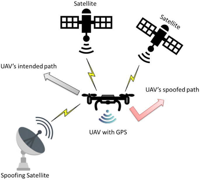
UAVs mostly suffer from Hijacking, denial-of-service (DoS) and distributed DoS attacks because of the unavailability of appropriate DoS/DDoS resistant strategies. Signal spoofing trough hijacking can harm the behavior of some UAVs. GPS Signal spoofing attacks occur due to inlaying or injecting wrong information from the GPS channels by the miscreant as illustrated in Fig. 16. In hijacking, full control of UAV can be stolen by the through inserting extra commands. Similarly, session hijacking can severely damage communication links of UAVs. Moreover, DoS attacks impose severe availability challenges as attacker can cause network congestion by sending multiple requests. DoS attacks occur due to overflow data in communication links to cause interruptions, putting extra load on processing units and by depleting the batteries. In DDos, the attacker overwhelms the UAV by sending traffic from several sources to introduce unreachability issues. These attacks can be mitigated by sensing, tracing signal distortion and high authentication.
-
Current countermeasure algorithms are available for single UAV networks. Thus, there is a need to develop or modify existing algorithms for multi-UAVs.
-
According to Shakhatreh et al. [101], existing simulation test beds are not complete mature. Similarly, available emulators for security analysis are only suitable for specific software and hardware designs. Thus, there is a need to develop customized simulators and tools.
-
Existing security analyses neglect the software and hardware differences for different types of UAVs. In contrast, some attacks only occur in particular software or hardware design. In contrast, security measures are suitable for any specific UAV and cannot be implemented to different UAV systems. Thus, there is a need to design unified security measure which can be implemented to all UAVs.
-
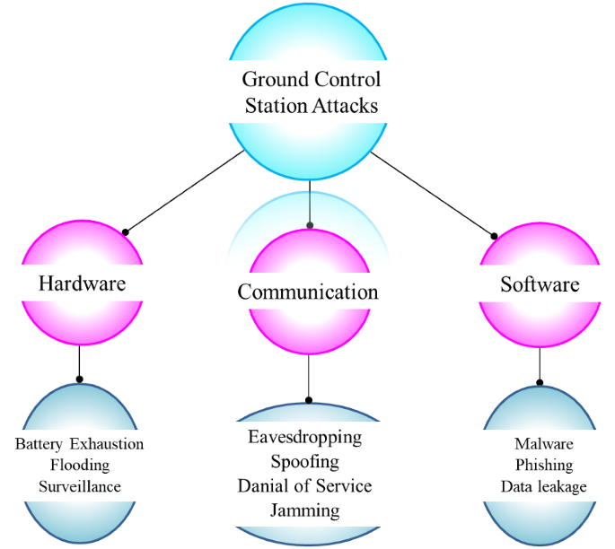
Among various security threats, GCS threats are very harmful as sensitive data can be leaked through software tools and malicious operating commands. A compromised GCS receives erroneous commands from attacker. These attacks usually occur due to viruses, key loggers and malwares. Mitigative solutions such as GCS authentications are needed to secure UAV data to be leaked to unauthorized processes, entities and users. Figure 17 illustrates some GCS attacks.
-
In some scenarios, attacker can misguide UAVs by sending some erroneous warning texts. It can cause network traffic jams. The attacker can masquerade as a legitimate user to give false information, wrong commands or corrupt data to substantially degrade UAV performance. These attacks occur due to the unavailability of authentication strategies as any adversary can pretend like a legitimate user to cause interference in the network.
-
In some cases, the attackers can steal the UAV path planning information or monitor UAV trajectories for any illegal activity by using this data. These threats can leverage the attacker UAV around the legitimate UAV.
-
Eavesdropping is another major concern which occurs due to the absence of preventive strategies like data encryption. In such scenario, the adversary can access the legitimate UAV’s data. Non-repudiation can be used to strengthen the security measures [124]. In such case, specific information is needed for any confirmation to prevent from security breaches.
-
Another important factor is the integrity of UAV mission which relates with data accuracy and transfer without any interference. If integrity protection strategies are absent, the data becomes invalid as attacker can damage the original data.
-
In some scenarios, UAV hardware components do not respond accurately and change their target behavior [125]. Such kinds of attacks are performed to cause UAV mission failure or steal confidential data.
-
Another critical attack is flight control computer attack which can change mission instructions or parameters to interrupt UAV flight control. On-board software or hardware tools can be used to protect from such attacks. It may contain warning generation, controller estimation or real-time monitoring in order to respond immediately against any possible risk.
-
In some cases, the attacker misguides UAV to stop following any intended trajectory through intended tampering on onboard navigational devices. Due to these attacks, the UAVs cannot provide accurate position and location to the control system.
-
It is highly critical to develop advanced mechanisms to combat ever evolving security risks against UAV communication, infrastructure and reliability. Major security concern related to delivery-based UAVs is hijacking, where attacker can steal or damage its load. In case of multimedia-, entertainment- or commercial-based UAVs, disruption its transmission can severely impact the whole network performance. In such scenario, UAV authentication is required, which can cause excessive delays. To cope with different security challenges, ML algorithms are proposed. ML-enabled physical layer security adopted to reduce the impact of malicious UAVs [127]. Furthermore, anti-jamming strategies can be implemented to enhance physical layer security (PLS) performance against potential jammers. In Table 14, we have summarized security issues in ML-based UAV networks.
Ground control station (GCS) attacks, motivated by Mansfield et al. [126]
7 Future research directions
In this section, we present several future research directions for further contributions on UAV research as follows:
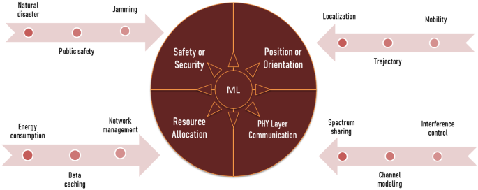
Even though AI schemes including machine learning strategies and neural networks have been used in UAVs, but deep learning and reinforcement learning strategies are yet to be implemented fully [138,139,140,141,142,143]. It is due to limited power constraints and processing utilities. Hence, researchers should find deep-learning-based novel strategies for UAVs, particularly for SAR mission [144]. These schemes can support contextual decisions and learning on the basis of trajectory information. The gathered information can be utilized to ensure efficient autonomous piloting of UAVs. As UAVs suffer from both storage and energy limitations, thus, lightweight and portable ML, DL, and RL approaches can be adopted to tackle these limitations. AI/ML-based solution can be implemented in a wide variety of scenarios for UAV communication as shown in Fig. 18.
-
Novel strategies for UAV energy harvesting and novel material for UAV batteries must be investigated to achieve extended missions [145]. Researchers should find new lightweight and efficient batteries to support enhance flight time for UAVs. Future studies must address efficient power control and energy consumption mechanism for UAVs.
-
Researchers should focus on finding power-efficient algorithms to process UAV’s data e.g., aerial imaging, video and sensing data in real-time. In [146], authors proposed a convolutional neural network method to assist avalanches search and rescue operation through UAV captured images. Similarly, algorithms for UAVs swarms, swarms optimization [147, 148], coordination, collision avoidance and UAVs trajectory plans are also needed.
-
It is envisaged that with the further development of UAVs with efficient standardizations, privacy rules, image processing algorithms, low-cost sensors, enhanced flight time and larger payload, there is a need to integrate UAVs in diverse applications such as field crop phenotyping [149].
-
Imaging processing techniques for UAVs face several critical issues such as varying image orientation, higher overlaps, variable scales and varying altitudes. Research fraternity should address these challenges in future investigations.
-
There is a need to propose efficient and real-time transmission lines inspection methods through UAVs, such as data analysis tools, cooperative platforms, robust tracking [150] and detection means, vision-based inspection and UAV low altitude photogrammetry approaches.
-
Researchers should focus on the implementation of new sensing devices, special cameras, multi decision making algorithms, multispectral imagery, coexistence of edge/fog computing [151, 152] or remote sensing and positioning mechanism to support efficient detection of soil, mapping crop status and other farming characteristics [153].
-
There is a need to propose more strategies for sensing, guidance, navigation and localization. Any problem in these techniques can cause failure in accuracy and timely delivery of parcels. Thus, researchers should investigate low-cost, efficient sensing devices and localization systems.
-
Further research contributions should be made toward using UAVs in resilient public safety networks. Future studies should address public safety communications, public health in disaster scenario, blockchain integration in UAVs to enhance health monitoring systems. In a recent study [154], authors addressed public safety network using UAVs.
-
Researchers should find adaptive control [155,156,157,158,159,160] and cooperative algorithms for multi-UAVs system. In current era, thousands of UAVs in the air form a network to perform various tasks such as drones light show, QR code generation and company’s logo design in air for promotion. There is a need to find robust coordination mechanisms to support such applications.
-
More research works should be carried out to assess adverse weather effects on UAV robustness to ensure successful mission implementation.
-
Data filtering techniques should be embedded in UAVs to prevent from redundant data, limit duplicate, illegal access and false locations. UAV can be integrated with emerging intelligent reflecting surfaces (IRS) to enhance PLS of IRS-assisted UAV system in different scenarios while maintaining computational intricacy and system performance [161].
-
In future, UAVs may be recharged through different types of energy resources such as fuel cell, solar cell and batteries to prolong flight time and endurance in persistent missions [162,163,164]. Considering hybrid power supply feature, it will important to effectively control UAV’s charging characteristics. In addition, UAVs can offload traffic and computation tasks to nearby ground vehicles in order to save power consumption. Thus, collaborative scheduling of hybrid power supply, communication and computation is an interesting research topic for further contributions.
-
UAV-empowered aerial caching can be adopted to achieve enhanced data throughput in IoT applications. In this context, size of caching contents, users mutual distances and optimizations of UAVs are the primary concerns to ensure feasibility.
-
There is a need to implement security algorithms such as blockchain in UAVs swarms, means putting more computation ability and storage capacity on UAVs. However, it can reduce UAV flight time and cause latency. Hence, further investigates are required to implement the security algorithms taking the resource-constrained nature of drones into account.
-
Cooperative path planning is highly significant for intelligent rendezvous generation and energy reduction for UAVs. Due to geographic limitations and highly dynamic network topology, smartly monitoring UAV’s flight in a collision-free and real-time manner has become a crucial issue. To overcome such issues for distributed and intelligent routing scheduling, deep reinforcement algorithms can be used through efficient transfer learning and accelerating the learning speed.
-
Present studies on UAVs mainly rely on trusted hardware or a third party integration, whose malfunction can severely damage the system. Therefore, there is a need to propose trust-free mechanisms to avoid illegal activity and develop trust for UAVs in an untrusted environment. In this regard, blockchain technology is a viable approach to ensure security. However, a major hurdle is to develop robust and lightweight blockchain system to withstand network fragmentation due to UAV’s constrained resources and high mobility. Moreover, it can cause complex incorporation problem and requires rigorous testing. Thus, a highly devoted architecture integrating features of both UAVs and blockchain technology is needed.
-
Existing blockchain-assisted UAV applications need a permissioned or private blockchain networks. These networks are critically vulnerable to threats in case of multi-UAVs networks. Moreover, due to increasing number of potential attacks such as game-theory-based attacks, machine learning (ML), and quantum-based attacks, it is essential to secure blockchain. Thus, research efforts are needed to make private blockchain networks safer, secure and immutable.
-
New set of regulations and policies for UAVs must be introduced and implemented to ensure efficient, reliable, secure and safe operations of the vehicles. Developing new standardizations is one of the major concerns as UAVs must be interoperable with the current technologies. In order to manage EM spectrum and its bandwidth, it is critically essential for UAVs not to be operating in the congested bandwidth and frequency spectrum. It is also crucial to keep the knowledge of published regulatory agreements by NATO for UAVs. This regulation defines the standard data protocols and message formats. It also enables a standard interface between ground coalitions and UAVs. Additionally, it indicates the coalition-shared database which permits data sharing between smart sources. In the US, the Federal Aviation Administration (FAA) provides certification for remote piloting, even for commercial operators. Commercial UAVs should follow the rules set by the FAA for reliable operations. For example, commercial UAVs must have a weight of 55 pounds and their operational range must be below 400 feet above the ground in case of uncontrolled airspace as indicated by Class G. On the other hand, certain authorizations and permissions must be attained to fly in controlled airspace as indicated by Class C, D and E [165]. UAVs which will be utilized for public operations must have a certificate issued from the FAA, operating body must comply with all regulations, rules, laws and federal of each specific area, city, province, state and country.
8 Conclusion
As UAVs have gained significant research attention, more and more patents and scientific articles are being published. The rapidly expanding research and development of UAVs is a consequence of these innovations. Furthermore, the demand for high mobility, more autonomy and bigger range of UAVs resulted in the design of novel systems for battery swapping, docking stations and precision landing. The application of these is already being used for fire detection and prevention, disaster monitoring, precision agriculture, wireless communication, remote sensing, power-line monitoring, and highway traffic control etc. In this regard, we comprehensively review ongoing developments of UAVs, accomplished by both academia and industrial sectors. We review academic contributions pertinent to UAV types, classifications, standardizations, swarms and charging methods. Furthermore, this study outlines the rapidly expanding interest of researchers, state authorities and business bodies to further harness and utilize the complete features of this promising technology. We briefly discuss UAV characteristics such as payload, altitude, range, speed, and flight time. Moreover, application scenarios, potential challenges and security issues are also examined. Finally, future research directions are identified to further hone the research work.
References
Grlj CG, Krznar N, Pranjić M (2022) A decade of UAV docking stations: a brief overview of mobile and fixed landing platforms. Drones 6(1):17
Rovira-Sugranes A, Razi A, Afghah F, Chakareski J (2022) A review of AI-enabled routing protocols for UAV networks: trends, challenges, and future outlook. Ad Hoc Netw 130:102790
Noor F, Khan MA, Al-Zahrani A, Ullah I, Al-Dhlan KA (2020) A review on communications perspective of flying ad-hoc networks: key enabling wireless technologies, applications, challenges and open research topics. Drones 4(4):65
Dronova I, Kislik C, Dinh Z, Kelly M (2021) A review of unoccupied aerial vehicle use in wetland applications: emerging opportunities in approach, technology, and data. Drones 5(2):45
Kim J, Kim S, Jeong J, Kim H, Park JS, Kim T (2018) CBDN: cloud-based drone navigation for efficient battery charging in drone networks. IEEE Trans Intell Transp Syst 20(11):4174–4191
Nourmohammadi A, Jafari M, Zander TO (2018) A survey on unmanned aerial vehicle remote control using brain–computer interface. IEEE Trans Hum-Mach Syst 48(4):337–348
Kanellakis C, Nikolakopoulos G (2017) Survey on computer vision for UAVs: current developments and trends. J Intell Rob Syst 87(1):141–168
Zhang S, Qian Z, Wu J, Kong F, Lu S (2016) Optimizing itinerary selection and charging association for mobile chargers. IEEE Trans Mob Comput 16(10):2833–2846
Aldhaher S, Mitcheson PD, Arteaga JM, Kkelis G, Yates DC (2017) Light-weight wireless power transfer for mid-air charging of drones. In: 2017 11th European conference on antennas and propagation (EUCAP). IEEE, pp 336–340
Lu M, Bagheri M, James AP, Phung T (2018) Wireless charging techniques for UAVs: a review, reconceptualization, and extension. IEEE Access 6:29865–29884
Raciti A, Rizzo SA, Susinni G (2018) Drone charging stations over the buildings based on a wireless power transfer system. In: 2018 IEEE/IAS 54th industrial and commercial power systems technical conference (I&CPS). IEEE, pp 1–6
Rohan A, Rabah M, Talha M, Kim SH (2018) Development of intelligent drone battery charging system based on wireless power transmission using hill climbing algorithm. Appl Syst Innov 1(4):44
Shin M, Kim J, Levorato M (2019) Auction-based charging scheduling with deep learning framework for multi-drone networks. IEEE Trans Veh Technol 68(5):4235–4248
Pham H, Smolka SA, Stoller SD, Phan D, Yang J (2015) A survey on unmanned aerial vehicle collision avoidance systems. arXiv preprint arXiv:1508.07723
Hayat S, Yanmaz E, Muzaffar R (2016) Survey on unmanned aerial vehicle networks for civil applications: a communications viewpoint. IEEE Commun Surv Tutor 18(4):2624–2661
Ebeid E, Skriver M, Jin J (2017) A survey on open-source flight control platforms of unmanned aerial vehicle. In: 2017 euromicro conference on digital system design (DSD). IEEE, pp 396–402
Geraci G, Garcia-Rodriguez A, Giordano LG, López-Pérez D, Björnson E (2018) Understanding UAV cellular communications: from existing networks to massive MIMO. IEEE Access 6:67853–67865
Fotouhi A, Qiang H, Ding M, Hassan M, Giordano LG, Garcia-Rodriguez A, Yuan J (2019) Survey on UAV cellular communications: practical aspects, standardization advancements, regulation, and security challenges. IEEE Commun Surv Tutor 21(4):3417–3442
Mozaffari M, Saad W, Bennis M, Nam YH, Debbah M (2019) A tutorial on UAVs for wireless networks: applications, challenges, and open problems. IEEE Commun Surv Tutor 21(3):2334–2360
Li B, Fei Z, Zhang Y (2018) UAV communications for 5G and beyond: recent advances and future trends. IEEE Internet Things J 6(2):2241–2263
Zhang L, Zhao H, Hou S, Zhao Z, Xu H, Wu X et al (2019) A survey on 5G millimeter wave communications for UAV-assisted wireless networks. IEEE Access 7:117460–117504
Ullah Z, Al-Turjman F, Mostarda L (2020) Cognition in UAV-aided 5G and beyond communications: a survey. IEEE Trans Cogn Commun Netw 6(3):872–891
Oubbati OS, Atiquzzaman M, Ahanger TA, Ibrahim A (2020) Softwarization of UAV networks: a survey of applications and future trends. IEEE Access 8:98073–98125
Zhi Y, Fu Z, Sun X, Yu J (2020) Security and privacy issues of UAV: a survey. Mob Netw Appl 25(1):95–101
Skorobogatov G, Barrado C, Salamí E (2020) Multiple UAV systems: a survey. Unmanned Syst 8(02):149–169
Jiang X, Sheng M, Zhao N, Xing C, Lu W, Wang X (2021) Green UAV communications for 6G: a survey. Chin J Aeronaut
Song Q, Zeng Y, Xu J, Jin S (2021) A survey of prototype and experiment for UAV communications. Sci China Inf Sci 64(4):1–21
Srivastava S, Narayan S, Mittal S (2021) A survey of deep learning techniques for vehicle detection from UAV images. J Syst Arch 117:102152
Haider SK, Nauman A, Jamshed MA, Jiang A, Batool S, Kim SW (2022) Internet of drones: routing algorithms. Tech Chall Math 10(9):1488
Poudel S, Moh S (2022) Task assignment algorithms for unmanned aerial vehicle networks: a comprehensive survey. Veh Commun 100469
Tahir A, Böling J, Haghbayan MH, Toivonen HT, Plosila J (2019) Swarms of unmanned aerial vehicles—a survey. J Ind Inf Integr 16:100106
Mairaj A, Baba AI, Javaid AY (2019) Application specific drone simulators: recent advances and challenges. Simul Model Pract Theory 94:100–117
kalpa Gunarathna J, Munasinghe R (2018) Development of a quad-rotor fixed-wing hybrid unmanned aerial vehicle. In: 2018 Moratuwa engineering research conference (MERCon). IEEE, pp 72–77
Sheng WEN, Jie HAN, Yubin LAN, Xuanchun YIN, Yuhua LU (2018) Influence of wing tip vortex on drift of single rotor plant protection unmanned aerial vehicle. Nongye Jixie Xuebao/Trans Chin Soc Agric Mach 49(8)
Lee D, Zhou J, Lin WT (2015) Autonomous battery swapping system for quadcopter. In: 2015 international conference on unmanned aircraft systems (ICUAS). IEEE, pp 118–124
de Souza BJO, Endler M (2015) Coordinating movement within swarms of UAVs through mobile networks. In: 2015 IEEE international conference on pervasive computing and communication workshops (PerCom Workshops). IEEE, pp 154–159
Pestana J, Sanchez-Lopez JL, de la Puente P, Carrio A, Campoy P (2014) A vision-based quadrotor swarm for the participation in the 2013 international micro air vehicle competition. In: 2014 international conference on unmanned aircraft systems (ICUAS). IEEE, pp 617–622
Fotouhi A, Ding M, Hassan M (2017) Understanding autonomous drone maneuverability for internet of things applications. In: 2017 IEEE 18th international symposium on a world of wireless, mobile and multimedia networks (WoWMoM). IEEE, pp 1–6
Al-Hourani A, Gomez K (2017) Modeling cellular-to-UAV path-loss for suburban environments. IEEE Wirel Commun Lett 7(1):82–85
Saggiani G, Persiani F, Ceruti A, Tortora P, Troiani E, Giuletti F, et al. (2007) A UAV system for observing volcanoes and natural hazards. In: AGU fall meeting abstracts, vol 2007, pp GC11B-05
Berman ES, Fladeland M, Liem J, Kolyer R, Gupta M (2012) Greenhouse gas analyzer for measurements of carbon dioxide, methane, and water vapor aboard an unmanned aerial vehicle. Sens Actuators, B Chem 169:128–135
Khan A, Schaefer D, Tao L, Miller DJ, Sun K, Zondlo MA et al (2012) Low power greenhouse gas sensors for unmanned aerial vehicles. Remote Sens 4(5):1355–1368
Watai T, Machida T, Ishizaki N, Inoue G (2006) A lightweight observation system for atmospheric carbon dioxide concentration using a small unmanned aerial vehicle. J Atmos Ocean Tech 23(5):700–710
McGonigle AJS, Aiuppa A, Giudice G, Tamburello G, Hodson AJ, Gurrieri S (2008) Unmanned aerial vehicle measurements of volcanic carbon dioxide fluxes. Geophys Res Lett 35(6)
Hill AC, Laugier EJ, Casana J (2020) Archaeological remote sensing using multi-temporal, drone-acquired thermal and Near Infrared (NIR) Imagery: a case study at the Enfield Shaker Village. New Hamps Remote Sens 12(4):690
Miyoshi GT, Arruda MDS, Osco LP, Marcato Junior J, Gonçalves DN, Imai NN et al (2020) A novel deep learning method to identify single tree species in UAV-based hyperspectral images. Remote Sens 12(8):1294
Lin YC, Cheng YT, Zhou T, Ravi R, Hasheminasab SM, Flatt JE et al (2019) Evaluation of UAV LiDAR for mapping coastal environments. Remote Sens 11(24):2893
Liu Z, Zhang Y, Yu X, Yuan C (2016) Unmanned surface vehicles: an overview of developments and challenges. Annu Rev Control 41:71–93
Ding M, Wang P, López-Pérez D, Mao G, Lin Z (2015) Performance impact of LoS and NLoS transmissions in dense cellular networks. IEEE Trans Wirel Commun 15(3):2365–2380
Hempe D (2006) Unmanned aircraft systems in the United States. In: US/Europe international safety conference
EASA UAS Workshop [Online]. https://www.easa.europa.eu/sites/default/files/dfu/ws_prod-g-doc-Events-2008-February-1-Overview-of-the-UAV-Industry-(UVS).pdf
ArcturusUAV. Jump 20 [Online]. https://arcturus-uav.com/product/jump-20
AlphaUnmmanedSystems. Alpha 800 UAV Helicopter [Online]. https://alphaunmannedsystems.com/alpha-800-uav/
DJI. DJI Agras MG-1P Series [Online]. https://www.dji.com/mg-1p/infor#specs
AgEagle Aeriel Systems Inc. AgEagle RX-60 Taking Agriculture Intelligence to the Next Level [Online]. https://docs.wixstatic.com/ugd/89e3c5_e3de865b41b644fbb68adea13706723c.pdf?index=true
Technical Specification Group Radio Access Network (2017) Study on Enhanced LTE Support for Aerial Vehicles (Release 15), 3GPP Standard TS 36.777
Use cases and spectrum considerations for UAS (unmanned aircraft systems) (2018). ETSI, Sophia Antipolis, France, Rep. 103 373
Functional architecture for unmanned aerial vehicles and unmanned aerial vehicle controllers using IMT-2020 networks (2017). ITU-T, Geneva
Lieb J, Volkert A (2020) Unmanned aircraft systems traffic management: a comparsion on the FAA UTM and the European CORUS ConOps based on U-space. In: 2020 AIAA/IEEE 39th digital avionics systems conference (DASC). IEEE, pp 1–6
Dronehub. Autonomous drones-in-a-Box. https://dronehub.ai
HIVE. Autonomous Drone Port. https://hive.aero
Skycharge. SKYPORT DP5 drone box hangar. https://www.skycharge.de/drone-box-hangar
Percepto. Percepto Base. https://percepto.co/air-mobile/
Security, N. https://www.nightingalesecurity.com/specs-faqs/
Campi T, Cruciani S, Feliziani M (2018) Wireless power transfer technology applied to an autonomous electric UAV with a small secondary coil. Energies 11(2):352
Wireless power transmission: patent landscape analysis [Online]. https://www.wipo.int/edocs/plrdocs/en/lexinnova_plr_wireless_power.pdf
AirMed&Rescue [Online]. https://www.airmedandrescue.com
Drone Market Report (2024) Drone Ind. Insights UG, Germany
Xu J, Zeng Y, Zhang R (2018) UAV-enabled wireless power transfer: trajectory design and energy optimization. IEEE Trans Wireless Commun 17(8):5092–5106
Hu Y, Yuan X, Jie Xu, Schmeink A (2019) Optimal 1D trajectory design for UAV-enabled multiuser wireless power transfer. IEEE Trans Commun 67(8):5674–5688
Song C, Kim H, Kim Y, Kim D, Jeong S, Cho Y et al (2018) EMI reduction methods in wireless power transfer system for drone electrical charger using tightly coupled three-phase resonant magnetic field. IEEE Trans Ind Electron 65(9):6839–6849
Jawad AM, Jawad HM, Nordin R, Gharghan SK, Abdullah NF, Abu-Alshaeer MJ (2019) Wireless power transfer with magnetic resonator coupling and sleep/active strategy for a drone charging station in smart agriculture. IEEE Access 7:139839–139851
Li J, Yin F, Wang L, Cui B, Yang D (2019) Electromagnetic induction position sensor applied to anti-misalignment wireless charging for UAVs. IEEE Sens J 20(1):515–524
Liu CH, Piao C, Tang J (2020) Energy-efficient UAV crowdsensing with multiple charging stations by deep learning. In: IEEE INFOCOM 2020-IEEE conference on computer communications. IEEE, pp 199–208
Hassija V, Chamola V, Krishna DNG, Guizani M (2020) A distributed framework for energy trading between UAVs and charging stations for critical applications. IEEE Trans Veh Technol 69(5):5391–5402
Qin C, Li P, Liu J, Liu J (2021) Blockchain-enabled charging scheduling for unmanned vehicles in smart cities. J Internet Technol 22(2):327–337
Zhu K, Yang J, Zhang Y, Nie J, Lim WYB, Zhang H, Xiong Z (2022) Aerial refueling: scheduling wireless energy charging for UAV enabled data collection. IEEE Trans Green Commun Netw
Oubbati OS, Lakas A, Guizani M (2022) Multi-agent deep reinforcement learning for wireless-powered UAV networks. IEEE Internet Things J
Fazelpour F, Vafaeipour M, Rahbari O, Shirmohammadi R (2013) Considerable parameters of using PV cells for solar-powered aircrafts. Renew Sustain Energy Rev 22:81–91
Woźniak W, Jessa M (2021) Selection of solar powered unmanned aerial vehicles for a long range data acquisition chain. Sensors 21(8):2772
Thipyopas C, Sripawadkul V, Warin N (2019) Design and development of a small solar-powered UAV for environmental monitoring application. In: 2019 IEEE Eurasia conference on IOT, communication and engineering (ECICE). IEEE, pp 316–319
Wu J, Wang H, Huang Y, Su Z, Zhang M (2018) Energy management strategy for solar-powered UAV long-endurance target tracking. IEEE Trans Aerosp Electron Syst 55(4):1878–1891
Gao XZ, Hou ZX, Guo Z, Chen XQ (2015) Reviews of methods to extract and store energy for solar-powered aircraft. Renew Sustain Energy Rev 44:96–108
Elkunchwar N, Chandrasekaran S, Iyer V, Fuller SB (2021) Toward battery-free flight: duty cycled recharging of small drones. In: 2021 IEEE/RSJ international conference on intelligent robots and systems (IROS). IEEE, pp 5234–5241
Dhingra D, Chukewad YM, Fuller SB (2020) A device for rapid, automated trimming of insect-sized flying robots. IEEE Robot Autom Lett 5(2):1373–1380
Keennon M, Klingebiel K, Won H (2012) Development of the nano hummingbird: a tailless flapping wing micro air vehicle. In: 50th AIAA aerospace sciences meeting including the new horizons forum and aerospace exposition, p 588
Förster J (2015) System identification of the Crazyflie 2.0 nano quadrocopter. Bachelor's thesis, ETH Zurich
SAS PD (2018) Parrot anafi specsheet
Technologies A (2015) Ascending technologies hummingbird
Technologies A (2015) Payload options & accessories
Systems ACUA (2017) Aerialtronics altura zenith specsheet
Solar Tribune (online). https://solartribune.com/solar-powered-drones/
Achtelik, M. C., Stumpf, J., Gurdan, D., & Doth, K. M. (2011, September). Design of a flexible high performance quadcopter platform breaking the MAV endurance record with laser power beaming. In: 2011 IEEE/RSJ international conference on intelligent robots and systems. IEEE, pp 5166–5172
Ouyang J, Che Y, Xu J, Wu K (2018) Throughput maximization for laser-powered UAV wireless communication systems. In: 2018 IEEE international conference on communications workshops (ICC workshops). IEEE, pp 1–6
Chen Q, Zhang D, Zhu D, Shi Q, Gu J, Ai Y (2015) Design and experiment for realization of laser wireless power transmission for small unmanned aerial vehicles. In: AOPC 2015: advances in laser technology and applications, vol 9671. International Society for Optics and Photonics, p 96710N
Lee S, Lim N, Choi W, Lee Y, Baek J, Park J (2020) Study on battery charging converter for MPPT control of laser wireless power transmission system. Electronics 9(10):1745
Kim Y, Shin HB, Lee WH, Jung SH, Kim CZ, Kim H et al (2019) 1080 nm InGaAs laser power converters grown by MOCVD using InAlGaAs metamorphic buffer layers. Sol Energy Mater Sol Cells 200:109984
Zhang Q, Fang W, Liu Q, Wu J, Xia P, Yang L (2018) Distributed laser charging: a wireless power transfer approach. IEEE Internet Things J 5(5):3853–3864
Jaafar W, Yanikomeroglu H (2020) Dynamics of laser-charged UAVs: a battery perspective. IEEE Internet Things J 8(13):10573–10582
Zhao MM, Shi Q, Zhao MJ (2020) Efficiency maximization for UAV-enabled mobile relaying systems with laser charging. IEEE Trans Wirel Commun 19(5):3257–3272
Shakhatreh H, Sawalmeh AH, Al-Fuqaha A, Dou Z, Almaita E, Khalil I et al (2019) Unmanned aerial vehicles (UAVs): a survey on civil applications and key research challenges. IEEE Access 7:48572–48634
Reinecke M, Prinsloo T (2017) The influence of drone monitoring on crop health and harvest size. In: 2017 1st international conference on next generation computing applications (NextComp). IEEE, pp 5–10
Maes WH, Steppe K (2019) Perspectives for remote sensing with unmanned aerial vehicles in precision agriculture. Trends Plant Sci 24(2):152–164
Menouar H, Guvenc I, Akkaya K, Uluagac AS, Kadri A, Tuncer A (2017) UAV-enabled intelligent transportation systems for the smart city: applications and challenges. IEEE Commun Mag 55(3):22–28
Elloumi M, Dhaou R, Escrig B, Idoudi H, Saidane LA (2018) Monitoring road traffic with a UAV-based system. In: 2018 IEEE wireless communications and networking conference (WCNC). IEEE, pp 1–6
Tiansawat P, Elliott S (2020) Unmanned aerial vehicles for automated forest restoration
De Almeida DRA, Broadbent EN, Ferreira MP, Meli P, Zambrano AMA, Gorgens EB et al (2021) Monitoring restored tropical forest diversity and structure through UAV-borne hyperspectral and lidar fusion. Remote Sens Environ 264:112582
Moura MM, de Oliveira LES, Sanquetta CR, Bastos A, Mohan M, Corte APD (2021) Towards Amazon forest restoration: automatic detection of species from UAV imagery. Remote Sens 13(13):2627
Zhang Y, Yuan X, Li W, Chen S (2017) Automatic power line inspection using UAV images. Remote Sens 9(8):824
Foudeh HA, Luk PCK, Whidborne JF (2021) An advanced unmanned aerial vehicle (UAV) approach via learning-based control for overhead power line monitoring: a comprehensive review. IEEE Access
Barbedo JGA (2019) A review on the use of unmanned aerial vehicles and imaging sensors for monitoring and assessing plant stresses. Drones 3(2):40
Sharma M, Gupta A, Gupta SK, Alsamhi SH, Shvetsov AV (2021) Survey on unmanned aerial vehicle for Mars exploration: deployment use case. Drones 6(1):4
Ubina NA, Cheng SC (2022) A review of unmanned system technologies with its application to aquaculture farm monitoring and management. Drones 6(1):12
Pulsiri N, Vatananan-Thesenvitz R (2021) Drones in emergency medical services: a systematic literature review with bibliometric analysis. Int J Innov Technol Manag 18(04):2097001
Mohsan SAH, Khan MA, Alsharif MH, Elhaty IA, Jahid A (2022) Role of drone technology helping in alleviating the COVID-19 pandemic. Micromachines 13(10):1593
Alqurashi FS, Trichili A, Saeed N, Ooi BS, Alouini MS (2022) Maritime communications: a survey on enabling technologies, opportunities, and challenges. arXiv preprint arXiv:2204.12824
Kourani A, Daher N (2021) Marine locomotion: a tethered UAV-Buoy system with surge velocity control. Robot Auton Syst 145:103858
Swaminathan N, Reddy SRP, Rajashekara K, Haran KS (2022) Flying cars and eVTOLs-technology advancements, powertrain architectures and design. IEEE Trans Transp Electr
Kasliwal A, Furbush NJ, Gawron JH, McBride JR, Wallington TJ, De Kleine RD et al (2019) Role of flying cars in sustainable mobility. Nat Commun 10(1):1–9
Griffiths S, Saunders J, Curtis A, Barber B, McLain T, Beard R (2007) Obstacle and terrain avoidance for miniature aerial vehicles. In: Advances in unmanned aerial vehicles. Springer, Dordrecht, pp 213–244
Winter T, Thubert P, Brandt A, Hui JW, Kelsey R, Levis P et al (2012) RPL: IPv6 routing protocol for low-power and lossy networks. RFC 6550:1–157
Kuriki Y, Namerikawa T (2014) Consensus-based cooperative formation control with collision avoidance for a multi-UAV system. In: 2014 American control conference. IEEE, pp 2077–2082
Vattapparamban E, Güvenç I, Yurekli AI, Akkaya K, Uluağaç S (2016) Drones for smart cities: issues in cybersecurity, privacy, and public safety. In: 2016 international wireless communications and mobile computing conference (IWCMC). IEEE, pp 216–221
He D, Chan S, Guizani M (2016) Communication security of unmanned aerial vehicles. IEEE Wirel Commun 24(4):134–139
Birnbaum Z, Dolgikh A, Skormin V, O'Brien E, Muller D, Stracquodaine C (2015) Unmanned aerial vehicle security using behavioral profiling. In: 2015 international conference on unmanned aircraft systems (ICUAS). IEEE, pp 1310–1319
Mansfield K, Eveleigh T, Holzer TH, Sarkani S (2013) Unmanned aerial vehicle smart device ground control station cyber security threat model In: 2013 IEEE international conference on technologies for homeland security (HST). IEEE, pp 722–728
Bithas PS, Michailidis ET, Nomikos N, Vouyioukas D, Kanatas AG (2019) A survey on machine-learning techniques for UAV-based communications. Sensors 19(23):5170
Yue X, Liu Y, Wang J, Song H, Cao H (2018) Software defined radio and wireless acoustic networking for amateur drone surveillance. IEEE Commun Mag 56(4):90–97
Liao Q, Fischer T, Gao J, Hafeez F, Oechsner C, Knode J (2018) A secure end-to-end cloud computing solution for emergency management with UAVs. In: 2018 IEEE global communications conference (GLOBECOM). IEEE, pp 1–7
Shoufan A, Al-Angari HM, Sheikh MFA, Damiani E (2018) Drone pilot identification by classifying radio-control signals. IEEE Trans Inf Forens Secur 13(10):2439–2447
Zohdi T (2020) The Game of Drones: rapid agent-based machine-learning models for multi-UAV path planning. Comput Mech 65(1):217–228
Min M, Xiao L, Xu D, Huang L, Peng M (2018) Learning-based defense against malicious unmanned aerial vehicles. In: 2018 IEEE 87th vehicular technology conference (VTC Spring). IEEE, pp 1–5
Hoang TM, Nguyen NM, Duong TQ (2019) Detection of eavesdropping attack in UAV-aided wireless systems: unsupervised learning with one-class SVM and k-means clustering. IEEE Wirel Commun Lett 9(2):139–142
Manesh MR, Kenney J, Hu WC, Devabhaktuni VK, Kaabouch N (2019) Detection of GPS spoofing attacks on unmanned aerial systems. In: 2019 16th IEEE annual consumer communications and networking conference (CCNC). IEEE, pp 1–6
Xiao L, Xie C, Min M, Zhuang W (2017) User-centric view of unmanned aerial vehicle transmission against smart attacks. IEEE Trans Veh Technol 67(4):3420–3430
Xiao L, Lu X, Xu D, Tang Y, Wang L, Zhuang W (2018) UAV relay in VANETs against smart jamming with reinforcement learning. IEEE Trans Veh Technol 67(5):4087–4097
Li C, Xu Y, Xia J, Zhao J (2018) Protecting secure communication under UAV smart attack with imperfect channel estimation. IEEE Access 6:76395–76401
Lv Z, Li Y, Feng H, Lv H (2021) Deep learning for security in digital twins of cooperative intelligent transportation systems. IEEE Trans Intell Transp Syst. https://doi.org/10.1109/TITS.2021.3113779
Liu F, Zhang G, Lu J (2020) Multi-source heterogeneous unsupervised domain adaptation via fuzzy-relation neural networks. IEEE Trans Fuzzy Syst. https://doi.org/10.1109/TFUZZ.2020.3018191
Zhang L, Zheng H, Cai G, Zhang Z, Wang X, et al. (2022) Power-frequency oscillation suppression algorithm for AC microgrid with multiple virtual synchronous generators based on fuzzy inference system. IET Renew Power Gener. https://doi.org/10.1049/rpg2.12461
Zhang L, Gao T, Cai G, Hai KL (2022) Research on electric vehicle charging safety warning model based on back propagation neural network optimized by improved gray wolf algorithm. J Energy Storage. https://doi.org/10.1016/j.est.2022.104092
Wu X, Zheng W, Chen X, Zhao Y, Yu T et al (2021) Improving high-impact bug report prediction with combination of interactive machine learning and active learning. Inf Softw Technol 133:106530. https://doi.org/10.1016/j.infsof.2021.106530
Chen P, Pei J, Lu W, Li M (2022) A deep reinforcement learning based method for real-time path planning and dynamic obstacle avoidance. Neurocomputing (Amsterdam) 497:64–75. https://doi.org/10.1016/j.neucom.2022.05.006
Carrio A, Sampedro C, Rodriguez-Ramos A, Campoy P (2017) A review of deep learning methods and applications for unmanned aerial vehicles. J Sensors 2017
Vergouw B, Nagel H, Bondt G, Custers B (2016) Drone technology: types, payloads, applications, frequency spectrum issues and future developments. In: The future of drone use. TMC Asser Press, The Hague, pp 21–45
Bejiga MB, Zeggada A, Nouffidj A, Melgani F (2017) A convolutional neural network approach for assisting avalanche search and rescue operations with UAV imagery. Remote Sens 9(2):100
Cao B, Gu Y, Lv Z, Yang S, Zhao, J., et al. (2021) RFID reader anticollision based on distributed parallel particle swarm optimization. IEEE Internet Things J 8(5):3099–3107. https://doi.org/10.1109/JIOT.2020.3033473
Hu Y, Qing JX, Liu ZH, Conrad ZJ, Cao JN et al (2021) Hovering efficiency optimization of the ducted propeller with weight penalty taken into account. Aerosp Sci Technol. https://doi.org/10.1016/j.ast.2021.106937
Yang G, Liu J, Zhao C, Li Z, Huang Y, Yu H et al (2017) Unmanned aerial vehicle remote sensing for field-based crop phenotyping: current status and perspectives. Front Plant Sci 8:1111
Yan J, Jiao H, Pu W, Shi C, Dai, J., et al. (2022) Radar sensor network resource allocation for fused target tracking: a brief review. Inf Fus 86–87:104–115. https://doi.org/10.1016/j.inffus.2022.06.009
Cao B, Fan S, Zhao J, Tian S, Zheng Z, Yan Y, et al. (2021) Large-scale many-objective deployment optimization of edge servers. IEEE Trans Intell Transp Syst 22(6):3841–3849. https://doi.org/10.1109/TITS.2021.3059455
Cao B, Sun Z, Zhang J, Gu Y (2021) Resource allocation in 5G IoV architecture based on SDN and Fog-cloud computing. IEEE Trans Intell Transp Syst 22(6):3832–3840. https://doi.org/10.1109/TITS.2020.3048844
Mogili UR, Deepak BBVL (2018) Review on application of drone systems in precision agriculture. Procedia Comput Sci 133:502–509
Wan S, Lu J, Fan P, Letaief KB (2017) To smart city: public safety network design for emergency. IEEE Access 6:1451–1460
Cao B, Zhang W, Wang X, Zhao J, Gu Y et al (2021) A memetic algorithm based on two_Arch2 for multi-depot heterogeneous-vehicle capacitated arc routing problem. Swarm Evolut Comput 63:100864. https://doi.org/10.1016/j.swevo.2021.100864
Li D, Ge SS, Lee TH (2021) Simultaneous-arrival-to-origin convergence: sliding-mode control through the norm-normalized sign function. IEEE Trans Autom Control. https://doi.org/10.1109/TAC.2021.3069816
Li D, Yu H, Tee KP, Wu Y, Ge SS et al (2021) On time-synchronized stability and control. IEEE Trans Syst Man Cybern-Syst. https://doi.org/10.1109/TSMC.2021.3050183
Wang J, Tian J, Zhang X, Yang B, Liu S, Yin L, et al. (2022) Control of time delay force feedback teleoperation system with finite time convergence. Front Neurorobot. https://doi.org/10.3389/fnbot.2022.877069
Gong X, Wang L, Mou Y, Wang H, Wei X, Zheng W, et al. (2022) Improved four-channel PBTDPA control strategy using force feedback bilateral teleoperation system. Int J Control 20(3):1002–1017. https://doi.org/10.1007/s12555-021-0096-y
Lu S, Ban Y, Zhang X, Yang B, Liu S, Yin L, Zheng W (2022) Adaptive control of time delay teleoperation system with uncertain dynamics. Front Neurorobot 16:928863. https://doi.org/10.3389/fnbot.2022.928863
Mohsan SAH, Khan MA, Alsharif MH, Uthansakul P, Solyman AA (2022) Intelligent reflecting surfaces assisted UAV communications for massive networks: current trends, challenges, and research directions. Sensors 22(14):5278
Mohsan SAH, Khan MA, Noor F, Ullah I, Alsharif MH (2022) Towards the unmanned aerial vehicles (UAVs): a comprehensive review. Drones 6(6):147
Mohsan SAH, Othman NQH, Khan MA, Amjad H, Żywiołek J (2022) A comprehensive review of micro UAV charging techniques. Micromachines 13(6):977
Khan MA, Kumar N, Mohsan SAH, Khan WU, Nasralla MM, Alsharif MH, et al. (2022) Swarm of UAVs for network management in 6G: a technical review. IEEE Trans Netw Serv Manag
Regulation & Policies [Online]. https://www.faa.gov/regulations_policies
Acknowledgements
This work is supported by the National Natural Science Foundation of China under grant 62261009, Ministry of Education Key Laboratory of Cognitive Radio and Information Processing (CRKL200106)
Author information
Authors and Affiliations
Corresponding author
Ethics declarations
Conflict of interest
The authors declare no conflict of interest.
Additional information
Publisher's Note
Springer Nature remains neutral with regard to jurisdictional claims in published maps and institutional affiliations.
Rights and permissions
Springer Nature or its licensor (e.g. a society or other partner) holds exclusive rights to this article under a publishing agreement with the author(s) or other rightsholder(s); author self-archiving of the accepted manuscript version of this article is solely governed by the terms of such publishing agreement and applicable law.
About this article
Cite this article
Mohsan, S.A.H., Othman, N.Q.H., Li, Y. et al. Unmanned aerial vehicles (UAVs): practical aspects, applications, open challenges, security issues, and future trends. Intel Serv Robotics 16, 109–137 (2023). https://doi.org/10.1007/s11370-022-00452-4
Received:
Accepted:
Published:
Issue Date:
DOI: https://doi.org/10.1007/s11370-022-00452-4


