Mobile mapping systems in civil engineering projects (case studies) Omar Al-Bayari Original Paper 17 May 2018 Pages: 1 - 13
Impact assessment of meteorological drought on rainfed agriculture using drought index and NDVI modeling: a case study of Tikamgarh district, M. P., India Pushpendra Singh RajpootAjay Kumar Original Paper 11 June 2018 Pages: 15 - 23
The impact of relative and absolute GNSS positioning strategies on estimated coordinates and ZWD in the framework of meteorological applications Alessandro FermiEugenio RealiniGiovanna Venuti Original Paper 19 July 2018 Pages: 25 - 38
Integrating dendrochronology and geomatics to monitor natural hazards and landscape changes Marco CiolliMarco BezziMaria Giulia Cantiani Original Paper 21 August 2018 Pages: 39 - 52
SEH-SDB: a semantically enriched historical spatial database for documentation and preservation of monumental heritage based on CityGML Reda YaagoubiAbdulkader Al-GilaniYehia Miky Original Paper 28 August 2018 Pages: 53 - 68
Code multipath analysis of Galileo FOC satellites by time-frequency representation Umberto RobustelliGiovanni Pugliano Original Paper 12 September 2018 Pages: 69 - 80
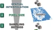
The effect of user-defined parameters on DTM accuracy—development of a hybrid model Ante ŠiljegMirko BaradaVlatko Roland Original Paper 24 September 2018 Pages: 81 - 96
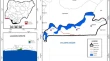
Evaluation of unsustainable land use/land cover change on ecosystem services in coastal area of Lagos state, Nigeria S. A. AdegboyegaJ. OloukoiO. E. Ajibade Original Paper 25 September 2018 Pages: 97 - 110