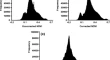
Formulation of Time Series Vegetation Index from Indian Geostationary Satellite and Comparison with Global Product Rahul NigamBimal Kumar BhattacharyaN. K. Patel Research Article 25 June 2011 Pages: 1 - 9
CO-Kriging Approach for Cartosat-1 Height Product with ICESat/GLAS Data for Digital Elevation Surface Generation Anil KumarParul Trivedi Research Article 01 July 2011 Pages: 11 - 17
Inversion of PROSAIL Model for Retrieval of Plant Biophysical Parameters Rahul TripathiRabi N. SahooS. Nagarajan Research Article 25 June 2011 Pages: 19 - 28
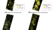
Remote Sensing of Eupatorium Adenophorum Spreng Based on HJ-A Satellite Data Jun ChenWenting QuanKai Lu Research Article 15 June 2011 Pages: 29 - 36
Above Ground Forest Phytomass Assessment in Southern Gujarat Prashant PatilSarnam SinghV. K. Dadhwal Research Article 22 June 2011 Pages: 37 - 46
Insight to Ecosystem Based Approach (EBA) at Landscape Level Using a Geospatial Medium Nidhi NagabhatlaSonali S. SellamuttuChiranjibi Pattanaik Research Article 25 June 2011 Pages: 47 - 64
Rainfall Estimation from Combined Observations Using KALPANA-IR and TRMM- Precipitation Radar Measurements over Indian Region Anoop Kumar MishraRakesh M. GairolaVijay K. Agarwal Research Article 25 June 2011 Pages: 65 - 74
Intra-Seasonal Oscillations Associated with Indian Ocean Warm Pool and Summer Monsoon Rainfall and Their Inter-Annual Variability P. M. MuraleedharanP. G. NishaK. U. Sivakumar Research Article 25 June 2011 Pages: 75 - 83
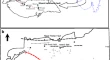
Identification of Loriya Fault, Its Reactivation Due to 2001 Bhuj Earthquake, (Using Remote Sensing Data) and Its Bearing on the Kachchh Mainland Fault, Kachchh District, Gujarat Pramod Kumar SinghSanjay DasS. R. Mohapatra Research Article 25 June 2011 Pages: 85 - 96
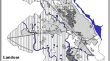
The Lost Natural Wetlands of Punjab (India): An Inventory Karanjot Kaur BrarVishwa Bandhu Singh Chandel Research Article 25 June 2011 Pages: 97 - 107
Municipal Solid Waste Management in Moradabad City, India Masood Ahsan SiddiquiSyed Mohammad RashidShahzad Ali Ansari Research Article 25 June 2011 Pages: 109 - 119
Multiresolution and Multispectral Data Fusion Using Discrete Wavelet Transform with IRS Images: Cartosat-1, IRS LISS III and LISS IV Anil Z. ChitadeS. K. Katiyar Short Note 06 July 2011 Pages: 121 - 128
Hyperspectral Satellite Data in Mapping Salt-Affected Soils Using Linear Spectral Unmixing Analysis Gautam GhoshSuresh KumarS. K. Saha Short Note 06 July 2011 Pages: 129 - 136
Artificial Neural Network (ANN) Based Inversion of Benthic Substrate Bottom Type and Bathymetry in Optically Shallow Waters - Initial Model Results P. V. NagamaniPrakash ChauhanM. M. Ali SHORT NOTE 01 July 2011 Pages: 137 - 143
Remote Sensing Study of Sittampundi Anorthosite Complex, India S. AnbazhaganN. K. SainabaS. Arivazhagan Short Note 25 June 2011 Pages: 145 - 153
Suitability Analysis of Groundwater Quality for Domestic and Irrigation Usage in Yamuna Nagar District, India: A GIS Approach Gulshan K. SethiBhagwan S. ChaudharyPraveen K. Thakur Short Note 29 June 2011 Pages: 155 - 165