Effects of Training Samples and Classifiers on Classification of Landsat-8 Imagery Ming ShangShi-Xin WangCong Du Research Article 16 June 2018 Pages: 1333 - 1340
Deriving Bathymetric Maps of the Shallow Coastal Water of the Gaza Strip Coastal Zone Using Passive Remotely Sensed Imagery Khaldoun AbualhinIrmgard Niemeyer Research Article 22 June 2018 Pages: 1341 - 1351
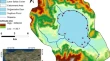
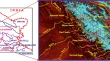
Evidence of Possible Recharge Zones for Lake Salda (Turkey) Hüseyin ÇaldırakBedri Kurtuluş Research Article 16 June 2018 Pages: 1353 - 1364
Regional Groundwater Assessment of Krishna River Basin Using Integrated GIS Approach P. HariniDinesh Kumar SahadevanM. J. Nandan Research Article 29 June 2018 Pages: 1365 - 1377
Changing Pattern of Channel Morphology of Alaknanda River in Srinagar Valley (Garhwal Himalaya), India D. D. ChauniyalSurajit DuttaSapna Semwal Research Article 28 June 2018 Pages: 1379 - 1387
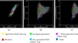
Anomaly Detection from Hyperspectral Images Using Clustering Based Feature Reduction Maryam Imani Research Article 22 June 2018 Pages: 1389 - 1397
Mapping Oolitic Iron Ore Deposits in the Ashumaysi Formation, Western Saudi Arabia, Using Different Remote Sensing Techniques Applied to Landsat 7 Enhanced Thematic Mapper Plus Data (ETM+) Habes A. GhrefatAbdullah A. Al ZahraniMahmoud A. Galmed Research Article 04 July 2018 Pages: 1399 - 1411
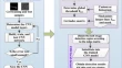
Study on the Combined Application of CFAR and Deep Learning in Ship Detection Ruifu WangJie LiYingjie Zhao Research Article Open access 15 June 2018 Pages: 1413 - 1421
A Minimum-Cost Path Model to the Bridge Extraction from Airborne LiDAR Point Clouds Sheng XuShanshan Xu Research Article 22 June 2018 Pages: 1423 - 1431
Canopy Structure Attributes Extraction from LiDAR Data Based on Tree Morphology and Crown Height Proportion Qingyan MengXu ChenZhenhui Sun Research Article 04 July 2018 Pages: 1433 - 1444
A Novel Remote Sensing Image Enhancement Method Using Unsharp Masking in NSST Domain Liangliang LiYujuan Si Research Article 28 June 2018 Pages: 1445 - 1455
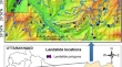
Spatial Prediction of Rainfall-Induced Landslides Using Aggregating One-Dependence Estimators Classifier Binh Thai PhamIndra PrakashDieu Tien Bui Research Article 07 July 2018 Pages: 1457 - 1470
Mapping the Extent of Agroforestry Area in Different Altitudes of Tehri District, North Western Himalaya, India Through GIS and Remote Sensing Data K. K. VikrantD. S. ChauhanAbhishek Maurya Research Article 04 July 2018 Pages: 1471 - 1480
Spatial Variability Mapping of Some Soil Properties in Jadwal Al_Amir Project/Babylon/Iraq Amal Muhammad Saleh Research Article Open access 16 July 2018 Pages: 1481 - 1495
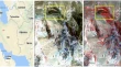
Monitoring of Snow Cover Variability in Chenab Basin Using IRS AWiFS Sensor B. P. RathoreS. K. SinghAnjana Vyas Research Article 12 July 2018 Pages: 1497 - 1506
Efficiency Evaluating of Automatic Lineament Extraction by Means of Remote Sensing (Case Study: Venarch, Iran) Adel SharifiAbbass MalianAbolfazl Soltani Research Article 09 July 2018 Pages: 1507 - 1518
Combining the FCM Classifier with Various Kernels to Handle Non-linearity of Class Boundaries Akshara Preethy ByjuAnil KumarA. Senthil Kumar Research Article 19 July 2018 Pages: 1519 - 1526
Automatic Registration of INSAT-3D Daily Images Using Mutual Information and Stochastic Optimization Technique Manthira Moorthi SubbiahDebajyoti DharSivakumar Ramamoorthy Research Article 31 July 2018 Pages: 1527 - 1535
Remote Sensing for Martian Studies: Inferences from Syrtis Major Vidhya Ganesh RangarajanRishikesh BhartiS. Dutta Review Article 02 August 2018 Pages: 1537 - 1551
George Joseph and C. Jeganathan: Fundamentals of Remote Sensing Vinay K. DadhwalSenthil Kumar Book Review 11 August 2018 Pages: 1553 - 1554