Geospatial analysis of ecological vulnerability of coffee agroecosystems in Brazil Marcelo de Carvalho AlvesFábio Moreira da SilvaGabriel Araújo e Silva Ferraz Original Paper 01 February 2013 Pages: 87 - 97
Integrating low-cost RTK positioning services with a web-based track log management system Daisuke YoshidaEugenio RealiniVenkatesh Raghavan Original Paper 05 February 2013 Pages: 99 - 108
GIS-driven classification of land use using IKONOS data and a core national spatial information database Ammatzia PeledMichael Gilichinsky Original Paper 12 February 2013 Pages: 109 - 117
Building 3D GIS data models using open source software Andrea Scianna Original Paper 16 February 2013 Pages: 119 - 132
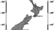
Analysis of a relative offset between vertical datums at the North and South Islands of New Zealand Robert TenzerNadim DayoubAhmed Abdalla Original Paper 24 February 2013 Pages: 133 - 145
A new methodology to manage Italian geodetic datums of the cadastral systems and of the historic maps G. TimárV. BaiocchiK. Lelo Original Paper 28 February 2013 Pages: 147 - 153
Co-registration of aerial photogrammetric and LiDAR point clouds in urban environments using automatic plane correspondence Costas ArmenakisYu GaoGunho Sohn Original Paper 03 March 2013 Pages: 155 - 166
Restoration scaling of seagrass habitats in the oceanic islands of Lakshadweep, India using geospatial technology E. P. NobiE. DilipanP. K. Dinesh Kumar Original Paper 09 March 2013 Pages: 167 - 175
Vector–raster server-side analysis: a PostGIS benchmark E. Agosto Original Paper 10 March 2013 Pages: 177 - 184