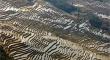
GIS-based detection of terraced landscape heritage: comparative tests using regional DEMs and UAV data Antonia SpanòGiulia SammartanoGiulia Possi Original Paper Open access 02 March 2018 Pages: 77 - 97
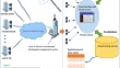
Designing a spatial cloud computing system for disaster (earthquake) management, a case study for Tehran Javad SadidiEshagh FakouriradParviz Zeaieanfirouzabadi Original Paper 03 March 2018 Pages: 99 - 111
Construction control and documentation of facade elements using terrestrial laser scanning Ján ErdélyiAlojz KopáčikPeter Kyrinovič Original Paper 09 March 2018 Pages: 113 - 121
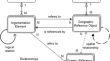
GeoWebEX: an open-source online system for synchronous collaboration on geographic information Muhammad A. ButtSyed Amer MahmoodSyed Muhammad Hassan Raza Original Paper 17 March 2018 Pages: 123 - 145
Estimation of water quality parameters using Landsat 8 images: application to Playa Colorada Bay, Sinaloa, Mexico Luis Carlos González-MárquezFranklin M. Torres-BejaranoJorge Antonio Sandoval-Romero Original Paper 26 March 2018 Pages: 147 - 158
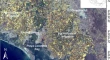
Modeling of inland flood vulnerability zones through remote sensing and GIS techniques in the highland region of Papua New Guinea Porejane HarleySailesh Samanta Original Paper 04 May 2018 Pages: 159 - 171