Abstract
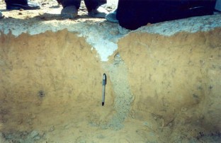
Of the intraplate seismic events, the January 26, 2001 Bhuj earthquake (Mw 7.7) would be remembered as one of the deadliest, in which 13,805 human lives were lost, 0.177 million injured and a total of 1,205,198 houses were fully or partly damaged in 16 districts of Gujarat state with an estimated overall loss of Rs. 284, 23 million. The brunt of the calamity was borne by five districts, namely Kachchh, Ahmadabad, Rajkot, Jamnagar and Surendranagar, where 99 % of the total casualties and damage occurred. In the neighbouring parts of Sindhh Province of Pakistan, 40 human casualties were reported, and some buildings cracked in the Karachi city as well. In the Kachchh district of Gujarat state, the telecommunication links and power supply were totally disrupted, road and rail links partially impaired and water supply snapped at many places. The Bhuj airbase had to be closed for some time due to damage to the infrastructure. The macroseismic survey carried out by the Geological Survey of India in an area as large as 1.2 million sq km indicated an epicentral intensity as high as X on the MSK scale in an area of 780 sq km in the central part of Kachchh rift basin. Apart from damages to civil structures, the January 26 earthquake induced conspicuous terrain deformation in the form of liquefaction features, structural ground deformation and low-order slope failures that were mainly prevalent within the higher intensity isoseists. Liquefaction occurred in an area of about 50,000 sq km. The extensive plains of Rann of Kachchh, the marshy tracts of the Little Rann and the shallow groundwater table zones of Banni Land provided the most conducive geotechnical environments for the development of seismites. The liquefaction activity was profuse in seismic intensity zones X and IX, widespread in intensity VIII, subdued in intensity VII and stray in intensity VI. The common forms of liquefaction were sand blows/boils, ground fissures, craters, lateral spreading and slumping. Ground deformation of tectonic origin was witnessed in the epicentral tract. Such features, though much less subdued in comparison with the 1819 large earthquake (Mw 7.8) in region, occurred along the Kachchh Mainland fault (KMF) and along a transverse lineament, referred to as Manfara–Kharoi fault. The manifestations were in the form of fractures, displacement of strata, linear subsidence, upheaval, formation of micro-basins/micro-ridges, ripping off of rock surface, and at places violent forms of liquefaction. The localities where coseismic deformations were observed include Bodhormora, Sikra, Vondh, Chobari, Manfara and Kharoi. The 2001 event has demonstrated the role of local geology in influencing the ground motion characteristics and, therefore, the hazard estimation.


References
Anon (2001a) Geology and mineral resources of Gujarat, Daman & Diu, Geological Survey of India Misc Publ no 30, Part XIV, p 102
Anon (2001b) Bhuj earthquake of Jan. 26, 2001. IMD consolidated preliminary report, p 44
Bhandari N, Sharma BK (2001) Damage pattern due to January 2001 Bhuj earthquake, India. Importance of site amplification and interference of shear waves. International conference on seismic hazard with particular reference to Bhuj earthquake, New Delhi, pp 19–21 (abstract volume)
Bhattacharya SN, Karanth RV, Dattatreyam RS, Sohoni PS (2004) Earthquake sequence in and around Bhavnagar, Saurashtra, western India during August-December, 2000 and associated tectonic feature. Curr Sci 86:1165–1170
BIS (2002) IS 1893 (Part 1): 2002 Indian standard criteria for earthquake resistant design of structures, part 1, general provisions and buildings. Bureau of Indian Standards, New Delhi
Biswas SK (2002) Structure and tectonics of the Kutch Basin, Western India with special reference to earthquakes. Eighth IGC Foundation Lecture, Mumbai, p 21
Biswas SK (2007) Structure and tectonics of Gujarat. In: Proceedings, seminar on seismology in India, Gandhinagar, pp 1–4
Hough SE, Pande P (2007) Quantifying the media bias in intensity surveys: lessons from 2001 Bhuj, India, earthquake. Bull Seismol Soc Am 97:638–645
Karanth RV, Sohoni PS, Mathur G, Khadkikar AS (2001) Geological observations of the 26 January 2001 Bhuj earthquake. J Geol Soc Ind 58:193–202
Mahajan AK, Kumar S, Kamal (2001) Macroseismic field observations of January 26th, 2001 Kutch Earthquake and its seismotectonics. International conference on seismic hazard with particular reference to Bhuj earthquake, New Delhi, pp 163–165 (abstract volume)
Narula PL, Chaubey SK, Sinha S (2002) Macroseismic survey, 2001 Bhuj, India earthquake reconnaissance report. In: Jain SK, Lettis WR, Murty CVR, Bardet J (eds) Earthquake Spectra, EERI publ no 2002–01, pp 45–50
Pande P (2003) Seismotectonic framework of the region and source mechanism of Kutch earthquake-2001. In: Pande P, Kayal JR (eds) Geological Survey of India special publ no 76, pp 225–233
Pande P (2008) Evaluation of seismotectonics of Kachchh rift basin, Gujarat, India and assessment of seismic hazard potential of the region. PhD thesis, University of Lucknow
Pande P (2010) Seismogenic microzones and seismic hazard potential of Kachchh peninsula, Gujarat, India. In: Williams et al (eds) Geologically active. Taylor & Francis Group, London, pp 569–578
Pande P, Sharda YP, Ghevaria ZG, Joshi KC, John B (2003a) Coseismic structural ground deformation. In: Pande P, Kayal JR (eds) Geological Survey of India special publ no 76, pp 163–171
Pande P, Joshi YC, Sharda YP, Joshi KC (2003b) Isoseismal map and isoseist characteristics. In: Pande P, Kayal JR (eds) Geological Survey of India special publ no 76, pp 147–153
Pande P et al (2003c) Macroseismic survey. In: Pande P, Kayal JR (eds) Geological Survey of India special publ no 76, pp 21–145
Pande P, Sharda YP, Ghevaria ZG, John B, Madhav C, Devrajan MK (2003d) Secondary effects of the earthquake. In: Pande P, Kayal JR (eds) Geological Survey of India special publ no 76, pp 173–187
Rajendran CP, Rajendran K (2001) The 1819 and 2001 Kutch earthquakes: a comparative perspective. International conference on seismic hazard with particular reference to Bhuj earthquake, New Delhi, pp 15–18 (abstract volume)
Rajendran K, Rajendran CP, Thakkar MG, Tuttle MP (2001) The 2001 Kutch (Bhuj) earthquake: coseismic surface features and their significance. Curr Sci 80:1397–1405
Rajendran K, Rajendran CP, Thakkar M, Gartia RK (2002) Sand blows from the 2001 Bhuj earthquake reveal clues on past seismicity. Curr Sci 83:603–610
Rastogi BK (2001) Ground deformation study of Mw 7.7 Bhuj earthquake of 2001. Episodes 24:160–165
Rastogi BK (2004) Damage due to the Mw 7.7 Kutch India earthquake of 2001. Tectonophysics 390:85–103
Rydelek PA, Tuttle M (2004) Explosive craters and soil liquefaction. Nature 427:115–116
Seed RB (2002) Dams. 2001 Bhuj, India earthquake reconnaissance report. In: Jain SK, Lettis WR, Murty CVR, Bardet J (eds) Earthquake spectra, EERI publ no 2002–1, pp 131–146
Shankar R, Pande P (2001) Geoseismological studies of Kutch (Bhuj) earthquake of 26th Jan 2001. J Geol Soc Ind 52:203–208
Singh RP, Sahoo AK, Bhoi S, Kumar MG, Bhuiyan C (2001) Ground deformation of the Gujarat earthquake of 26 January 2001. J Geol Soc India 58(3):209–214
Acknowledgments
The author is grateful to the Director General, Geological Survey of India for according permission to publish the paper and JR Kayal for critical reviewing.
Author information
Authors and Affiliations
Corresponding author
Rights and permissions
About this article
Cite this article
Pande, P. Geoseismological investigation of the January 26, 2001 Bhuj earthquake in western peninsular India. Nat Hazards 65, 1045–1062 (2013). https://doi.org/10.1007/s11069-012-0182-9
Received:
Accepted:
Published:
Issue Date:
DOI: https://doi.org/10.1007/s11069-012-0182-9


