
Abstract
Luliang County is located in the east of Yunnan Province, knew as the “Pearl of eastern Yunnan”. It is located in the upper reaches of the Nanpan River and is under the jurisdiction of Qujing City. In the modern era, higher requirements are made for the development of Luliang County. In order to improve the river flood control system, control the domestic pollution along the river, repair the damaged water ecosystem, create a waterfront landscape belt, and create basic conditions for the construction of “the most beautiful dam area”, Luliang water authority has given priority to the comprehensive river regulation project of Luliang County, Qujing City, according to the principle of first trial and highlighting key points. According to the current conditions of the Laopanjiang River and the Yanfang River, based on the principles of safety, integrity, ecology, protection, context and hydrophilicity, taking the construction of “Luliang water town and the most beautiful dam area” as the overall concept, the rich water network is used to connect the five prominent natural resources of “mountain, water, forest, field and village”, highlighting the local folk culture, water conservancy development history Cuan culture has three cultural characteristics. Coordinate the development of surrounding land, and activate the popularity of the site, promote local economic development, create a land of fish and rice with common prosperity of people and water, and reproduce the brilliance of “East Yunnan pearl, plateau granary” through reasonable functional layout and facility layout of river center, beach, Boulder, ecological wooden pile, aquatic plants and aquatic animals.
You have full access to this open access chapter, Download conference paper PDF
Keywords
1 Introduction
The dependence on rivers has changed from simple survival and economic utilization to diversified needs, paying attention to the return of river public ties, paying attention to the development of waterfront environment and the construction of corridor ecological greening, and improving the interactive relationship between people and rivers, which can not only reduce the misunderstanding and regret of development and construction, but also create a good carrier space for the city to shape rich urban culture, citizen spirit and Ecological Landscape (Zheng 2012). On May 4, 2018, the feasibility study report on the comprehensive river regulation project in Luliang County passed the review of the expert group (Tang 2018; Tang 2020), which is the first project in the overall concept of “Pearl River green source”, and the river regulation in Luliang County has entered a new stage (Li et al. 2021). The task of river regulation is no longer part of the traditional dredging of river channels and reinforcement of river banks. “Smooth river, clear water, green back and beautiful scenery” have become the standard of comprehensive river regulation in the modern era. The provincial government also hopes to be able to revitalize the resources along and around the river through river regulation to drive the development of tourism and economy. Luliang water Township can make use of the rich water network to connect the five natural resources of “mountain, water, forest, field and village”, take water as the core, integrate pastoral scenery with cultural landscape, and combine modern and traditional planning and governance concepts, improve the flood control capacity of river channels, control the domestic pollution along the river (Wang et al. 2020; Liu and Gu 2020), transform the surrounding environment, repair the damaged water ecosystem, ensure the ecological base flow, create a waterfront landscape belt and improve the river ecological landscape, Create a unique landscape of plateau water town and form a new landmark of Qujing City (Wu 2020). Create a river ecological landscape project integrating urban water environment landscape and ecological agriculture sightseeing, experience, leisure and vacation, fully tap and make use of Luliang’s historical and cultural connotation and resources, and carry out environmental remediation of the moat and the Yanfang River through flood control and drainage, water diversion into the city, water ecological restoration and other measures, so as to create the Yanfang River ecological pastoral landscape and moat urban water landscape, and improve the urban quality from flood control, water environment, ecology Comprehensive treatment of landscape and other aspects.
The ecological green corridor uses the concept of landscape ecology to explore the application and practice of landscape ecology in the spatial planning and design of urban ecological green space from the perspective of landscape elements (Zhou 2021). This paper discusses how to make a localized and poetic urban ecological corridor landscape planning and design through the creation of scenic spot artistic conception, plant planting planning and landscape sketch design, integrating local historical context and regional characteristics in the process of urban ecological corridor landscape construction (Li 2015). Built on the analysis of ecological environmental base and ecological sensitivity, the landscape ecological pattern is the framework, and the distinctive landscape ecological planning is carried out from the perspective of landscape structure and function layout according to relevant laws, regulations and technical specifications. The ecological corridor is superimposed with the landscape corridor and recreation corridor to build a continuous landscape ecological pattern, and the multi-path corridor considering their own factors forms a more stable ecological network (Yan et al. 2016).
Therefore, according to the requirements of “minutes of Symposium on comprehensive river regulation project in Luliang County” and “design of feasibility study stage of comprehensive river regulation project in Luliang County”, the design and research of Ecological Green Corridor Project for comprehensive river regulation in Luliang County is carried out. Build suitable habitat and environmental elements by artificial means, accelerate the restoration of ecosystem, and build a complete river ecological corridor, so as to provide assistance in regional ecological security of Luliang County.
2 Current Situation Analysis
2.1 The Waterfront Landscape Design is Single and Cannot Show the Regional Cultural Characteristics
As showed in Fig. 1, the current form of revetment is single, and the river with a length of more than ten kilometers basically adopts only one or two typical section forms. In the past, the traditional river planning scheme focused on the construction of water safety, with low requirements for water landscape and water culture, leading to the current situation of the remaining projects are mostly stereotyped and lack of beauty. Instancing River shown in Fig. 2 is close to the municipal road, and the section form is also a definite traditional hydraulic section, with a definite spatial level. Although the vegetation coverage on both banks is brought up, the plant planting is chaotic and lacks characteristics and reasonable plant color planning, resulting in a general overall landscape experience.
The residential buildings on both sides of the Laopanjiang River are densely distributed, and most of them hold the embankment, which belongs to illegal buildings. There are many folk cultural buildings on both sides, representing rich folk culture, such as Guansheng temple and Qinglong Temple (shown in Fig. 3), as well as many hydraulic structures with characteristics of the times, such as Xinba sluice (shown in Fig. 4).
As showed in Fig. 5, regardless of the fact that the cross-section form of the Yanfang River is single, large agricultural gardens and a small amount of wetlands are made available on both banks, with wide vision and good pastoral landscape resources.
These landscapes, which can fully reflect the history and regional characteristics of local water conservancy development and local characteristic folk culture, have not been fully respected, protected and utilized in previous planning projects, which is a major gap in the current comprehensive management of river courses.

Current embankment

Current embankment of the Laopanjiang River

Guansheng temple and Qinglong temple on the Bank of the Laopanjiang River

Xinba sluice on the Laopanjiang River
As showed in Fig. 5, despite the fact that the cross-section form of theYanfang River is single, large agricultural gardens and a small amount of wetlands are distributed on both banks, with wide vision and pleasant pastoral landscape resources.
These landscapes, which can fully reflect the history and regional characteristics of local water conservancy development and local characteristic folk culture, have not been fully respected, protected and utilized in previous planning projects, which is a major gap in the current comprehensive management of river courses.

Rural scenery along the Yanfang River
2.2 Lack of Recreational Facilities and Green Leisure Places
At present, there are basically no landscape nodes arranged on both banks of the river for staying and shading, which is seriously missing in hydrophilicity. This not only blocks the relationship between man, nature and rivers, but also makes these three rivers lose their basic functions as important public recreational space in cities and towns, and can not provide a convenient green leisure place for the general public and villagers along the river.
2.3 The Watery Landscape System with Convenient Access and Organic Integration has not been Formed
The three rivers are the lack of connection, which can not create an organically integrated, accessible and convenient water landscape system for the city. At present, although there are intersections between instancing River and the Laopanjiang River, instancing River and cunningly River, the connection between rivers is weak and there is a lack of certain distribution and conversion space, resulting in the inability of these three rivers to effectively gather popularity and the dispersion of people and vehicles. At present, three relatively separated waterfront landscape space cannot form a whole, and the accessibility and convenience are poor. Figure 6 shows the intersection of the Xinpanjiang River and Yanfang River.

Intersection of XinPan River and the Yanfang River
3 Design Principles and Concepts
3.1 Design Principles
1) Safety principle - flood control priority, on the premise of meeting the flood control function. 2) Overall principle - landscape design must fully consider the needs of urban planning, tourism planning and other relevant planning, and uniformly consider the buildings and land attributes around the land to reflect the image of the city. 3) Ecological principles - follow the principles and methods of “landscape ecology” to create rich and diverse river habitats. 4) Protection principle - protect the basic farmland within the design scope. On the basis of not requisitioning the basic farmland and not changing the land use nature of the basic farmland, highlight the farmland texture through reasonable landscape design methods, so as to achieve a win-win effect of reducing the cost of land requisition and showing the scenery of characteristic farmland. 5) Context Principle - respect and make rational use of regional cultural characteristics, pay attention to the communication and interaction between modern and traditional, and show the unique water culture of the river. 6) Hydrophilic principle - meet people’s needs to be close to nature and water. 7) People oriented, pay attention to the construction of human feelings in urban and rural public space, and enhance the sense of belonging of local residents.
3.2 Design Concepts
In view of the three major problems existing in the current situation of the site, this landscape design will: 1) highly integrate natural and cultural resources and create a waterfront landscape space with regional cultural characteristics in combination with urban positioning. 2) Give full consideration to the leisure needs of local residents and tourists and create rich and diverse activity facilities. 3) Realize the effective connection of points, lines and surfaces, and create a waterfront landscape tourism system with clear theme, accessibility and convenience.
Taking the construction of “Luliang water town, the most beautiful dam area” as the overall concept, the rich water network is used to connect the five prominent natural resources of “mountain, water, forest, field and village”, highlighting the three cultural characteristics of local folk culture, water conservancy development history and Cuan culture. Coordinate the development of surrounding land, activate the popularity of the site, promote local economic development, create a land of fish and rice with common prosperity of people and water, and reproduce the brilliance of “Pearl of East Yunnan and granary of Plateau” through reasonable functional layout and facility layout.
4 General Layout
4.1 Overall Spatial Layout
According to the different contemporary characteristics of the three rivers and the needs of urban development, the overall layout structure is “one heart and three belts”, and seeks to create a waterfront landscape pattern suitable for living, tourism and industry. Of which:
-
1)
One heart: the core of ecological service of Panjiang wetland
The project proposes building Panjiang wetland at the core of the connection between the lower reaches of the Laopanjiang River and the central area. Panjiang wetland will make full use of its characteristic natural resources such as farmland, pond and wetland, unique Cuan cultural resources, convenient location and transportation, and coordinate the development needs of surrounding land and urban positioning on the basis of no expropriation of basic farmland, reasonable protection and utilization, so as to build a core of Panjiang wetland ecological tourism service integrating ecological tourism, leisure and entertainment and popular science education. Completion of Panjiang wetland can not only effectively improve the ecological and aesthetic characteristics of waterfront landscape, but also effectively stimulate the improvement of surrounding land value and the development of real estate industry, and stimulate provincial economic growth.
-
2)
Three belts: three ecological landscape belts connecting the central area
-
(1)
The Xinpanjiang River- fast green sightseeing channel
With the theme of “urban greenway, beautiful scenery”, comprehensively optimize the greening on both sides of instancing River, select important landscape nodes and landscape belts for greening upgrading, and plant colored leaf plants to form a boulevard with rich corridor landscape color, so as to create a fast green sightseeing channel connecting Qujing urban area and Luliang center.
-
(2)
The Laopanjiang River-ecological and cultural landscape belt
With the theme of “ancient water town, looking for mountains and asking for water”, restore the crisscross water network of the Laopanjiang River, integrate the folk customs, legendary literature, water conservancy history and other historical resources of local villages and towns, take advantage of the undulating mountains in the distance, make full use of the current distribution of a large number of vegetable fields, beaches and local architectural layout, try to avoid demolition, integrate all favorable resources, and create water streets, water lanes Watercourses and other scenic spots full of the charm of the ancient capital.
The ecological and cultural landscape belt is about 19 km long. According to the site characteristics and the distribution of surrounding resources, it can consist of three zones to form the landscape structure of “one river and three areas”. From the upstream to the downstream, the three areas are ancient village cultural tourism area, water village charm leisure area and water conservancy development experience area.
-
(3)
The Yanfang River-ecological pastoral landscape belt
With the theme of “beautiful countryside and long green water flow”, combined with the surrounding ecological agricultural scenic spots, create an ecological pastoral leisure atmosphere, integrate the slow greenway design, highlight the concept of pastoral and health, set up scenic spots such as characteristic fishing points, picking points and greenway post stations, and create an ecological pastoral landscape belt integrating light viewing, entertainment, ecological experience and leisure sports, Create a rich and diversified slow walking healthy greenway for local residents and tourists.
Being dependent on the current situation of “confusion” with a length of about 15 km, the landscape structure of “confusion” is proposed. “Three parts” refer to the folk culture park, cunningly ecological pastoral Park and cunningly Fengming Wetland Park. “Four corridors” to refer to cunningly ecological greenway, which is divided into four characteristic corridors, from downstream to upstream: sport corridor, ginkgo corridor, fishing corridor and Lin language corridor.
-
(1)
4.2 Layout of Ecological Restoration Work
The composition, structure and distribution pattern of natural riparian biological community are very different from those in dry land areas. It is a great transitional and interlaced zone for the exchange of material, energy and information between the river ecosystem and terrestrial ecosystem. Natural rivers have significant practical and potential values in controlling bank erosion, regulating microclimate, protecting river water quality, being home for aquatic and terrestrial animals and plants, maintaining river biodiversity and ecosystem integrity, improving river landscape quality and carrying out tourism activities. In fact, the water level, flow and velocity of the natural river channel that has not been greatly transformed by human beings change with the change of seasons, which fully reflect the operation law of nature. The rapids, slow flows, floodplains and deep pools generated by hydraulic and geological evolution in the natural river channel also provide rich and diverse habitats for aquatic organisms, and the local aquatic organisms also change their habitat and living rules, which is the result of the slow evolution of nature.
In the past, the main purpose of municipal and rural river regulation was to prevent water and soil loss and flood control. The vertical concrete and mortar masonry flood dike are the basic methods used for river revetment, resulting in the diversification of river habitat into simplification, the disappearance of some aquatic organisms with special ecological requirements and the reduction of species diversity. Therefore, reconstructing the diversity of river habitat is an urgent means in river regulation.
The ecological restoration task of this project is designed to transform the contemporary river based on its current status, provide more abundant habitats for aquatic organisms, and meet the habitat needs of river biological species as much as possible.
4.2.1 Zoning of Ecological Restoration Work
-
1)
Upper reaches of the Laopanjiang River
In the bucolic river section, there are basically no buildings on both sides, with little human interference, and there are many beaches on both sides of the river, which can make habitats with rich diversity. This section is used as an ecological restoration area, and the project includes the release of river course, beaches, boulders, aquatic plants and aquatic animals. Supplement emergent plants and repair the existing submerged plants.
-
2)
Lower reaches of the Laopanjiang River
In the village river section, there are dense buildings on both banks and large human interference, so small-area habitats can be built depending on regional conditions. This section serves as an ecological construction area, and the project content is to pile up boulders (a small amount), wooden piles, aquatic plants and aquatic animals.
-
3)
Yanfang River-Zhongyuan Ze
In the rustic river section, except for the most downstream river section, there are few buildings on both banks and little human interference. However, due to the recent regulation, it is not apt to undertake major actions in the river section to avoid disturbing the newly restored ecosystem. This section serves as an ecological maintenance area, and the project content is to pile boulders, wooden piles, emergent plants and aquatic animals.
Natural rivers are composed of numerous habitat elements. In the comprehensive regulation of the Nanpan River, on the premise of not damaging the built river embankment project, through some relatively simple habitat construction, a variety of river morphological elements are brought together to make diversified habitats and promote the healthy development of the ecosystem. The river habitat construction elements mainly include the following types: River core, beach, Boulder, ecological stake, aquatic plant and aquatic animal food chain construction. In addition, in view of the problem that the water and grass of the Laopanjiang River are too lush and hinder flood discharge, the water and grass trimming measures of the Laopanjiang River will be implemented.
4.2.2 Habitat Restoration Design
-
1)
River shoal design
A pure river will form a river heartland owing to sediment deposition at the outlet of the torrent. Because it is very difficult for human beings to reach and less disturbed by human activities, the river heartland is a safe place for a variety of organisms to inhabit and survive.
The design of expansion is mainly used to restore the diverse forms of river channels, provide places apt for amphibians and birds that are difficult to be disturbed by human beings, change the regional flow pattern and form a richer flow pattern division. The design principles of expansion are as follows: relying on the micro- terrain at the bottom of the river, reduce the amount of earthwork. Combined with the existing siltation points to prevent hydraulic scouring and hollowing out.
In this habitat structure project, the river heartland is at the rate of the thick part of the country river section in the upper reaches of the Laopanjiang River, and Yanfang River does not set river heartland.
As showed in Fig. 7, No. 1 extension is in the chainage of the Laopanjiang River 0 + 350 ~ 0 + 600, with an area of 4088 m2. The river bottom elevation of this section is exceeded, so it has the inherent advantage of constructing river shoals.
Fig. 7. 
Scope of No. 1 River shoal
As shown in Fig. 8, No. 2 River heartland is located between chainage 2 + 600 and 2 + 800, with an area of 1860 m2. The original high convex land at the center of the river indicates that the hydrological situation here is conducive to sediment deposition and is suitable for the construction of River heartland.
Fig. 8. 
River shoals under construction
It is necessary to backfill the planting soil on the river shoal, with a backfill thickness of 0.3 m, and plant emergent plants, mainly local moist plants reed, Zizania latifolia, rush grass and water taro, so as to attract birds to stay and provide habitat for amphibians.
-
2)
Beach land
Shoal is a commonplace river habitat structure in mountainous rivers, and it is the spawning ground of some fish and shrimp. The fine sand in the bank shoal is washed away by the water flow, and the gap between the gravels becomes larger, becoming the habitat of aquatic insects, attached algae and other organisms, which in turn attracts all kinds of fish for food, thus becoming the living space of all kinds of aquatic animals.
Depending on the field survey, there is a considerable area of beach habitat in the upper reaches of the Laopanjiang River. The project mainly relies on the existing beach in the river embankment to maintain the existing terrain as far as possible, protect and transform it. Engineering measures are mainly greening, and the quantities are integrated into the landscape greening project.
-
3)
Boulder
As showed in Fig. 9, boulders can modify the direction of water flow, guide deposition, and from a variety of river environments such as river beach depression and still water area. Boulders in the river block the flow of water, change the flow pattern and oxygenate the river. The bottom of the boulder is another critical habitat for aquatic insects and molluscs. The gap between the boulders is a pretty good biological shelter, and the top of the boulder can also be utilized as a place for birds to stop.
In order to enrich the morphological diversity of the river channel and increase the habitat, boulders are given to the narrow upright, stable and steep river section according to the topographic characteristics of the river section. Among them, on the 4.5 km long river channel in the upper reaches of the Laopanjiang River, four ecological boulders with a volume of 0.2 m3 are placed every 50 m, with a total of 72 m3 boulders. On the 14.3 km long river channel in the lower reaches of the Laopanjiang River, two ecological boulders with a volume of 0.2 m3 are placed every 50 m, and a total of 114.4 m3 boulders are placed. On the 15.2 km long river course of the Yanfang River, four ecological boulders with a volume of 0.2 m3 are placed every 50 m, with a total of 243.2 m3 boulders.
Fig. 9. 
Boulder and Wooden pile
-
4)
Ecological stake
As showed in Fig. 10, the stump can also provide ecological water supply for vertebrates and birds, as showed in the singular ecological diagram. Since there are small houses on both sides of the upper reaches of the Laopanjiang River and there is relatively little human interference in the river, ecological wooden piles will not be added, but only in the lower reaches of the Laopanjiang River and Yanfang River.
Fig. 10. 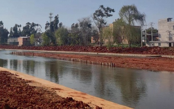
Wooden pile
In the 14.3 km long river channel in the lower reaches of the Laopanjiang River, a group of wooden piles are set every 100 m, each group is composed of 25 pine trees with a length of 4 m and a tail diameter of 0.12 M. In the Yanfang River, two groups of wooden piles are set every 100 m, each consisting of 25 pine trees with a length of 4 m and a tail diameter of 0.12 M. The wooden pile should be located 5–8 m offshore, and the length of the exposed part is about 0.5–1 m.
-
5)
Aquatic plant
Aquatic plants are found and food for a variety of animals, and can also purify water quality and beautify the environment. Since there are many submerged plants in the regulated river section, the planting of submerged plants will not be aggregated, and only emergent plants will be placed. The planting range is the Laopanjiang River and Cunningly River, in which the planting length in the upper reaches of the Laopanjiang River accounts for 20%, the planting River in the lower reaches of the Laopanjiang River accounts for 40%, and the planting River in cunningly River accounts for 30%. Many kinds of plants are planted in landscape festivals around the point. The planting width is about 0.5 m, and each section can be adapted with singular theme colors. The color system is divided into yellow system (Acorus calamus and Canna flavor), red system (Canna safflower), pink system (calcium), white system (taro), variegated system (cattail and reed), etc. take a spot walk to create a rich plant landscape. Aquatic plants are given in Fig. 11.
Fig. 11. 
Aquatic plants
Depending on statistics, 900 m2 emergent plants are positioned in the upper reaches of the Laopanjiang River, 5720 m2 emergent plants are planted in the lower reaches of the Laopanjiang River, and 4560 m2 emergent plants are planted in the Yanfang River. There are many submerged plants at the bottom of the Laopanjiang River, which affects flood discharge and is not hard to be covered with garbage. After the submerged plants die and decay, they will release nitrogen and phosphorus into the water body, causing seasonal deterioration of water quality. Therefore, it is necessary in order to locally harvest the submerged plants at the bottom of the river and clean up the garbage. The growth area of the ongoing submerged plants accounts for about 60% of the area at the bottom of the river. In order to properly preserve the current habitat, some submerged plants will be removed. The area ratio of 30% is always retained. The total cleaning scale is 169200 m2.
-
6)
Aquatic animals
Aquatic animals include zooplankton, benthos and fish. They feed on free bacteria, planktonic algae and organic debris in the water, which can effectively reduce child suspended solids in the water is enhanced the transparency of the water. Putting aquatic animals with an appropriate quantity and reasonable species ratio into the water body plays an obvious role in prolonging the food chain of the water environment ecosystem and improving the effect of biological purification.
The project plans to properly stocking zooplankton, benthos (mussels, snails, etc.) and fish (grass carp, carp) and other aquatic animals in the water body, extending the food chain, optimizing the food web structure and building a complete river ecosystem. Being dependent on statistics, 846 kg zooplankton, 5076 kg zoobenthos and 8460 kg fish were put into the Laopanjiang River. A total of 684 kg zooplankton, 4104 kg zoobenthos and 6840 kg fish were put into the Yanfang River.


4.3 Constructions of a Rapid Transit System
-
1)
Analysis of current traffic system
According to the revision of Luliang County Urban Master Plan (2012–2030), except instancing, the red line of the project is not within the planning area of the urban master plan, and the overall traffic accessibility between the suburban area and the suburbs is poor.
The plan points out that in order to relieve the pressure of transit traffic on the central area of the city, it is planned to build the ring road and the ring transit line, and consider the ring east line on the east side of Nanpan River as the long term planning content. In the long term, Binjiang Avenue on the Jiangxi side of Nanpan River will be invoked as the ring of the east line.
Although the planned road can establish a basic road framework for the east of the urban area, it fails to meet the needs of the rapid development of the urban area, and fails to form an effective connection with the nodes such as characteristic towns, river landscape and ecological agriculture that have developed rapidly in the suburbs in recent years.
On the whole, there is a lack of effective momentary connection between suburban areas and principal urban areas, which limits the progress of urbanization to a certain extent.
-
2)
Rapid transit system construction
According to the regional characteristics, urban development planning, current transportation system characteristics and future development direction of Luliang County, it is therefore proposed to add secondary roads, supplement rural road network, and set up multiple shared parking lots at the same time. The rapid transit system can effectively evacuate a large number of traffic and people from the inner urban area of Luliang County and the central urban area of Qujing, and quickly connect the inner urban area with the outlying area. The design of rapid transit system emphasizes “communication”, which can provide tourists with fast sightseeing channels. The slow traffic system of “one heart, three belts” emphasizes “reaching”, which allows tourists to swim, slow down and stay in the slow traffic system with pleasant scale and scenery and multiple landscape nodes after arrival, so as to create a green ecological Waterfront Resort. The two will form an effective connection and form a characteristic sightseeing route for mutual benefit.
According to the revision of Luliang County Urban Master Plan (2012–2030), the planned construction of Ring Road and ring transit line is a long term plan, and the completion time has not intended to determine. Therefore, the newly added secondary roads and rural roads in the project are constructed according to the traffic road standard of 6 m wide agricultural logistics park, and the planned Ring Road along Laopanjiang River is also constructed according to the traffic road standard of 6 m wide agricultural logistics park, so as to ensure the smooth connection of the overall external traffic of the project. The aggregate length of the traffic load of the agricultural logistics park constructed by the project is about 41.6 km.
After the construction time of the planned construction of the ring road and the transit line around the city is determined, the pertinent departments can use the project to extend and expand the traffic load of the agricultural logistics park, so as to avoid repeating projects.
-
(1)
New class II Highway
The newly added class II highway is mainly arranged along the Jiangxi Bank of the Laopanjiang River. The planned highway connecting the ring road and the transit line around the city can improve the main ring road network of the county, which owns the advantages of rapidity and convenience. Through the overall horizontal and vertical layout, the newly added class II highway can quickly guide and evaluate the traffic flow pressure from the principal urban area and fully activate the popularity of the site.
-
(2)
Improve rural road network
On the basis of the current scattered rural road network, according to the river direction, important project nodes, surrounding important scenic spots and other resource conditions, the new rural road network connected with the secondary road network can effectively alleviate the traffic pressure of the secondary road network, improve the overall accessibility and hierarchy of the suburban area, and provide diversified choices for citizens and tourists.
-
(3)
Set up green transfer service points
The green transfer service point is mainly arranged at the intersection of class II Highway and slow traffic system, and has the service functions of rapid transfer, parking, bicycle rental and so on. Tourists can quickly reach the service point through the ancillary highway, and quickly enter the lengthy travel system through the service functions such as parking and renting bicycles.
-
(1)
5 Discussion and Conclusions
The waterfront landscape design of the Xinpanjiang River, Laoanjiang River and Yanfang River are single, which can not show the regional cultural characteristics. The lack of recreational facilities makes it impossible to provide a green leisure place for citizens. In addition, the three rivers are lack of connection, which can not create an organically integrated, accessible and convenient water landscape system for the city. Therefore, based on the current water system conditions of Luliang County, the design and research of the ecological green corridor project for comprehensive river treatment in Luliang County are carried out:
-
1)
Based on the principles of safety, integrity, ecology, protection, context and hydrophilicity, build the overall concept of “Luliang water Township, the most beautiful dam area”, use the rich water network to connect the five prominent natural resources of “mountain, water, forest, field and village”, and highlight the three cultural characteristics of local folk culture, water conservancy development history and Cuan culture. According to the different current characteristics of the three rivers and the needs of urban development, the overall layout structure is “one heart and three belts”, and strive to create a waterfront landscape pattern suitable for living, tourism and industry.
-
2)
Based on the zoning of the ecological restoration project, the layout of the ecological restoration project is carried out, and then the habitat restoration design is carried out. On the basis of the current river channel, it is transformed, and the river habitat elements such as river core, beach, Boulder, ecological stake, aquatic plant and aquatic animal food chain are reasonably optimized and constructed, so as to provide a richer habitat for aquatic organisms and meet the habitat needs of river biological species as much as possible.
-
3)
According to the regional characteristics, urban development planning, current transportation system characteristics and future development direction of Luliang County, it is suggested to add secondary roads, supplement rural road network, and set up multiple public parking lots at the same time. The rapid transit system can effectively evacuate a large number of traffic and people from the central urban area of Luliang County and the central urban area of Qujing, and quickly connect the central urban area with the suburban area. The design of rapid transit system emphasizes “communication”, which can provide tourists with fast sightseeing channels. The slow traffic system of “one heart, three belts” emphasizes “reaching”, which allows tourists to swim, slow down and stay in the slow traffic system with pleasant scale and scenery and multiple landscape nodes after arrival, so as to create a green ecological Waterfront Resort. The two will form an effective connection and form a characteristic sightseeing route for mutual benefit.
In a word, through the use of artificial means to build suitable habitats and environmental elements, accelerate the recovery of the ecosystem, and build a complete river ecological corridor, in order to contribute to regional ecological security of Luliang County.
References
Li H (2015) Planning and design of ecological corridor in Nanyang Xixia stork river road based on the regional characteristics. Mod Landsc Architect 12(6):462–468 (in Chinese)
Li LB, He XD, Yi SL (2021) Study on the present situation, problems and comprehensive treatment measures of the Laopanjiang river channel in Luliang County in Yunnan Province. Water Resour Dev Manag 9:19–24 (in Chinese)
Liu Y, Gu J (2020) Study on sewage treatment of old buildings along the river. Water Resour Dev Manag 6:39–42 (in Chinese)
Tang SF (2018) Feasibility study report on comprehensive river regulation project in Luliang County. China Water Resources Pearl River Planning, Surveying and Designing and Designing Co. Ltd., Guangzhou, China. (in Chinese)
Tang SF (2020) Preliminary design report of comprehensive river regulation project in Luliang County, Qujing City, Yunnan Province. China Water Resources Pearl River Planning, Surveying and Designing and Designing Co. Ltd., Guangzhou, China. (in Chinese)
Wang L, Yang MQ, Guo WZ (2020) Application of physical-ecological composite restoration technology in black-odor rivers regulation. Water Resour Dev Manag 7:1–7 (in Chinese)
Wu DP (2020) Analysis on comprehensive treatment of water environment in Luliang County, Yunnan Province. Flood Control Drought Relief China 30(4):43–47 (in Chinese)
Yan J, Xiang ZJ, Ling J (2016) Study on landscape ecological planning of Shijiu Lake and Ma’anshan Lake area. Resour Environ Yangtze River Basin 25(9):1375–1383 (in Chinese)
Zheng DF (2012) Exploration on city river’s function returning from “edge line” to “public link”—A case study of ecological green corridor planning of Chuan Yang river. Shanghai Urban Plan 1:67–73 (in Chinese)
Zhou WW (2021) Research on space shaping method of urban ecological green corridor based on landscape ecology—Taking landscape planning and design of optical valley ecological corridor as an example. Urban Hous 28(12):96–98 (in Chinese)
Acknowledgements
This study are supported by the scientific research projects entrusted by Yunnan water conservancy and Hydropower Engineering Co., Ltd. “Research on the regulation and harmless treatment technology of water hyacinth migration path in the comprehensive treatment of river channel in Luliang County, Qujing City, Yunnan Province” and “Research on the impact assessment and Countermeasures of river discharge into Luliang County, Qujing City, Yunnan Province on the regulation effect of river channel comprehensive treatment project”. This research is also supported by the National Natural Science Foundation of China (No. 41776024, No. 42176166).
Author information
Authors and Affiliations
Corresponding author
Editor information
Editors and Affiliations
Rights and permissions
Open Access This chapter is licensed under the terms of the Creative Commons Attribution 4.0 International License (http://creativecommons.org/licenses/by/4.0/), which permits use, sharing, adaptation, distribution and reproduction in any medium or format, as long as you give appropriate credit to the original author(s) and the source, provide a link to the Creative Commons license and indicate if changes were made.
The images or other third party material in this chapter are included in the chapter's Creative Commons license, unless indicated otherwise in a credit line to the material. If material is not included in the chapter's Creative Commons license and your intended use is not permitted by statutory regulation or exceeds the permitted use, you will need to obtain permission directly from the copyright holder.
Copyright information
© 2023 The Author(s)
About this paper

Cite this paper
Yi, S., Sun, S., Huang, G., Wu, D., Qu, W. (2023). Study on the Design of Ecological Green Corridor Project for Comprehensive River Treatment in Luliang County, Yunnan Province. In: Li, Y., Hu, Y., Rigo, P., Lefler, F.E., Zhao, G. (eds) Proceedings of PIANC Smart Rivers 2022. PIANC 2022. Lecture Notes in Civil Engineering, vol 264. Springer, Singapore. https://doi.org/10.1007/978-981-19-6138-0_112
Download citation
DOI: https://doi.org/10.1007/978-981-19-6138-0_112
Published:
Publisher Name: Springer, Singapore
Print ISBN: 978-981-19-6137-3
Online ISBN: 978-981-19-6138-0
eBook Packages: EngineeringEngineering (R0)