
Abstract
Luliang County of Yunnan Province has identified tourism as one of the four pillar industries, and established the new concept of large tourism, large resources, large market and large development, so as to make tourism a new growth point of Luliang County’s national economy and the leader of the tertiary industry. Luliang will be integrated into a scenic spot with water as the core, integrating pastoral scenery with cultural landscape, combining modernity with tradition, beautiful and comfortable tourism environment, complete facilities and reasonable planning. Taking the opportunity of the national implementation of the river head system, Rural Revitalization and rural complex construction, taking the Xinpanjiang River, the Laopanjiang River and Yanfang River as the framework and aiming at “smooth river, clear water, green bank and beautiful scenery”, the project fully excavates and makes use of Luliang’s historical and cultural connotation and resources through flood control and drainage, sewage collection and treatment along the river, ecological green corridor, the waterfront landscape improvement and other measures shall be taken to comprehensively manage the three rivers, so as to create the waterfront landscape pattern of one heart and three belts of the wetland ecological tourism service core of the Xinpanjiang River and the Laopanjiang River Basin, the fast green tourism channel of the Xinpanjiang River, the ecological and cultural landscape belt of the Laopanjiang River and the ecological pastoral landscape belt of the Yanfang River, so as to improve the urban taste and the people’s sense of obtaining a beautiful ecological environment. The project falls within the poverty-stricken area of fish. Rice and water township on the plateau, and its functional orientation is mainly ecological agricultural sightseeing, experience and poverty-stricken vacation. Therefore, the construction of waterfront landscape belt, park node construction and greening promotion along the Xinpanjiang River, the Laopanjiang River and the Yanfang River have beautified the environment of the dam area, created space for tourists and citizens to visit, visit and relax, and laid a solid foundation for the development of tourism in Luliang County.
You have full access to this open access chapter, Download conference paper PDF
Keywords
1 Introduction
Luliang County shown in Fig. 1 is situated on the east of Yunnan Province, known as the “Pearl of eastern Yunnan” (Wang et al. 2020), located in the upper reaches of the Nanpanjiang river and under the jurisdiction of Qujing City. Over the past few years, with the steady implementation of the Western national development strategy and the vital bridgehead protection strategy of opening up the southwest, Luliang County has made rapid economic and social development and urban construction. In the modern era, higher requirements are made for the advance of Luliang County. According to the “concept of green source construction of the Pearl River”, Luliang water Township mainly uses rich water network and connects the five prominent natural resources of “mountain, water, forest, field and village” to form a new landmark of Qujing City. It will be the best mountain tourism, parent-child tourism, farm food, wedding photography and summer resort in Qujing City. According to the 13th five year plan for tourism in Luliang County, Qujing City, Luliang County defines tourism as one of the four pillar industries, establishes the new concept of large tourism, large resources, large market and large development, and makes tourism a new growth point of Luliang County’s national economy and the dragon head of the tertiary industry. Luliang will be incorporated into a scenic spot with water as the core, rural scenery and cultural landscape integrated, modern and traditional, beautiful and comfortable tourism environment, complete facilities and reasonable planning (Yu 2018).
Depending on the area division in the plan, the construction project belongs to the poverty-stricken area of fish and rice water township on the plateau, and its functional orientation is mainly ecological agricultural sightseeing, experience and poverty-stricken Vacation (Zeng et al. 2013). Therefore, carry out waterfront landscape belt construction, park node construction, greening and upgrading along XinPan River, Laopan River and the Yanfang River, beautify the environment of the dam area, and create space for tourists and citizens to visit, visit and relax, so as to lay a solid foundation for the development of tourism in Luliang County.
Pastoral complex is the inevitable product of agrarian production and socio-economic development of a certain stage. It is the breakthrough of agrarian progress. It can effectively relieve the pressure of municipal functions, improve rural natural and living environment, and become the carrier of artistic creativity (Hu and Zheng 2018). The overall rural landscape planning is based on the investigation and evaluation of the rural landscape environment, takes the landscape science theory as the foundation, takes the landscape analysis as the core, takes the landscape planning and design technology system as the support, takes the rural human settlement environment construction as the center, and takes the rural sustainable development as the goal, carries out the landscape zoning and landscape planning of the rural landscape environment, and determines the overall characteristics, overall pattern and overall development direction of the rural landscape (Guo and Wang 2000).
Therefore, according to the action plan for the construction of beautiful and livable villages in Yunnan Province and the 13th five year plan for tourism in Luliang County, Qujing City formulated by Yunnan provincial government, the planning and design of ecological pastoral cultural landscape belt of main river system in Luliang, Yunnan Province is carried out (Tang 2020).

The location and water system distribution of Luliang County
2 Slow Greenway and Facade Reconstruction of Buildings Along the River
2.1 Design of Slow Greenway
The dike tops road connecting lampooning along the whole line. On the one hand, a dike road integrating greenway function is added for the river section lacking dike road, so as to realize the greenway connection of lampooning; On the other hand, for the current 3–5 M wide rural road, the surrounding greening shall be improved to create a cool and comfortable greenway environment. At the same time, in order to better respond to the tourists on the greenway and residents on both sides of the Strait, a series of recreational viewing nodes are designed for the project, which is arranged at judicious intervals. Figure 2 is only an aerial view of the newly-built embankment section.
-
1)
New embankment section
For the construction of slow-moving Greenway in the green embankment section, a pleasant and comfortable greenway landscape is mainly created through the color asphalt pavement project, which is organically coupled with the existing rural roads to constitute a complete and unobstructed greenway tour system. On the basis of the allowable width of the bank slope, local secondary leisure walking paths and hydrophilic wood plank roads are added to create a diversified and multi-level slow-moving greenway system.
Fig. 2. 
Aerial view of new embankment
-
2)
Current rural section
The average width of the current pastoral road is 3–4 m, and most of the posterior slope is distributed with dense residential buildings, with large passenger flow. In view of the contemporary pastoral sections, we should concentrate on improving the greening on both banks. On the one hand, greening can be used to cover the residential buildings with larger volume and unsightly appearance. On the other hand, we can comprehensively improve the ecological environment of the greenway through rich greening landscape. At the same time, on the premise of sufficient bank slope width, secondary hydrophilic platforms are added locally to enrich the spatial hierarchy of greenways. Figure 3 shows in the aerial view of the new-built rustic road section.
Fig. 3. 
Aerial view of new-built rural road


The core service objects of the rest and viewing service shop are tourists and villagers on both sides of the Strait, which is designed to provide a convenient, comfortable and simple living waterfront place according to local conditions.
In view of the current situation, a large number of fragmented beaches and vegetable fields are distributed in the embankment defense line on both sides, and the landscape can be improved uniformly, which can be transformed into natural landscapes such as the lotus pond and wetland. Figure 4 is the new-built greenway rest and viewing service points.

Greenway rest and viewing service point
A few greenways and pavilions, which can be combined with the cultural demand, can serve as a unified place for the reconstruction of the green road and the pavilion, and can be used as a place for the reconstruction of the green road and the abandoned Pavilion, which can greatly improve the cultural connotation of the building.
2.2 Facade Reconstructions of Buildings Along the River
There are a number of dense residential buildings on both sides of lampooning River, including many illegal residential buildings on the bank slope. These residential buildings lack overall planning and are mostly constructed by villagers spontaneously. Therefore, architectural features and styles on both sides of the Strait are clustered, and the overall building facade lacks aesthetic feeling. Therefore, through the unified building facade transformation, the project comprehensively improves the architectural style on both sides of the Laopanjiang River and is dovetailed with the overall style of the slow-moving Greenway of the Laopanjiang River. The architectural style of the facade of buildings along the river should follow the characteristics of local traditional villages and folk houses, partially retain the architectural characteristics of traditional tile roofed houses, extract the characteristic elements such as window flowers as unified symbols, start with Chinese style and use modern elements to create the facade image with traditional beauty and modern technology. Figure 5 shows the buildings along the river.

Facade reconstruction of buildings along the river
3 Characteristic Zoning
In addition to the construction of slow-moving greenways along the whole line, the lampooning ecological and cultural belt also makes full use of the favorable landscape conditions such as idle ponds, wetlands and green spaces around the greenway, plans the overall resources, transforms and improves moderately, and turns the whole ecological and cultural landscape belt into a three-dimensional green corridor landscape belt with changeable space, different sizes and different moving scenery.
The ecological and cultural landscape belt is about 19 km long. According to the site characteristics and the distribution of surrounding cultural and natural resources, it can consist of three zones to form the landscape structure of “one river and three areas”. Being the sequence of time in advance, the three areas from upstream to downstream are ancient village cultural sightseeing area, water village charm leisure area and water conservancy historical experience area. The upstream section highlights the origin of lampooning river and village, the midstream section highlights the change and integration of people, rivers and villages, and the downstream section highlights the harmony, prosperity and progress of people and water. Each of the three zones gets its characteristics. Tourists can experience the changing history of people and water from prehistoric times to contemporary times by visiting the slow greenway.
-
1)
Ancient village cultural tourist area-Origin
Inspired by the local village history and local characteristic folk architecture (such as Guan Shenggong Temple), and guided by the allusions and deeds of ancestors and celebrities (such as the repeated achievements of Lu Liang Zhizhou and Du Zhen), the ancient village culture is highlighted through sightseeing and leisure design to explain the history of ancestors living in water and burying the seeds of civilization.
The ancient village is cultural tourism area mainly includes two landscape nodes: Dugong Kaiyuan and autumn scenery of the ancient village. The main construction contents are as follows: according to the current terrain, transform the current banded pond into five ecological reservoirs with the function of purifying water quality, form a continuous and changeable banded waterfront space combined with the facility layout of the entrance square, multiple hydrophilic platforms and wooden plank roads in the south, highlight the rich animal and plant community landscape in the wet land, and become the main hydrophilic leisure place for residents and tourists; Greening and upgrading the existing sparse forest and grassland to create a richer plant community, so as to have scenery in four seasons. At the same time, multiple rest and viewing platforms are arranged to facilitate residents to relax and visit outdoors; Reasonably arrange multiple theme sculptures, cultural landscape walls and other specific landscape signs to enrich the artistry and experience of the space and create a characteristic folk waterfront greenway landscape. Figure 6 shows in the aerial view of autumn nodes in the ancient village.
-
2)
Shuixiang charm leisure area-change
Taking the literary history of recording the local natural mountains and rivers, characteristic features and cultural monuments as the clue, extract the relevant descriptions of the Laopanjiang River in literary biographies and oral legends, and combine the current environment of the Laopanjiang River, design a belt tour system that can be visited, played and appreciated, and use the ups and downs and rich and changeable three-dimensional landscape belt to metaphor the change history of the Laopanjiang river for many years, so as to create a water town charm leisure area with great regional characteristics. The layout of the leisure setting of the landscape belt is intimately combined with the surrounding cultural scenic spots. Through the efficient layout of the viewing platform, it can effectively connect with the surrounding cultural scenic spots, effectively collect and distribute the flow of people, and create a comfortable and convenient waterfront green belt.
Fig. 6. 
Aerial view of autumn nodes in ancient village
The water town charm leisure area mainly includes six nodes: Qingding Zixi, Delin Qingyin, tianjiangshenma, Feilai jade, Lingmeng flower fragrance and Biquan yingyue. The main construction contents are: transforming a few low-lying green spaces into the central landscape, arranging landscape corridors, wooden platforms and other rest facilities around the lake, focusing on optimizing the current greening environment, through rich plant planting design and semi private and semi open enclosed waterfront space design, Create a natural and comfortable gathering and leisure place connected with the greenway. Figure 7 shows in the aerial view of flower fragrance node named Lingmeng and Fig. 8 shows in the aerial view of spring reflecting the moon node.
Fig. 7. 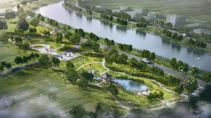
Aerial view of Lingmeng flower fragrance node
Fig. 8. 
Aerial view of Biquan yingyue node
-
3)
Water conservancy development experience area – Development
Taking the history of frequent flood and drought disasters in the Nanpanjiang River and the climax of water conservancy construction after the founding of the people’s Republic of China as the clue, make full use of the characteristic water conservancy buildings such as Xinba sluice retained in the current situation, highlight the theme of ecological water conservancy, and reflect the image of harmonious coexistence, prosperity and development between mankind and nature. The design transforms the existing fish pond into an ecological landscape lake with purification function, and combines a series of water education facilities to create a hydrophilic space integrating water conservancy schooling, popular science exhibition, sightseeing and rest.
The water conservancy development experience area mainly has four nodes: half river water color, legendary stage, colorful flower sea and water moistening all things. The main construction contents are: create an open and shared first impression through the design of open entrance square and entrance landscape wall logo, which can effectively attract popularity and create an open and comfortable green corridor entrance landscape; Transform the abandoned hydraulic structures into a Water Conservancy Museum, combined with the interactive installation of water art, to create an entrance space that can be learned, visited, played and rested; The landscape of the existing pond is improved through the layout of rainwater garden, hydrophilic steps, platforms and Wangjiang Pavilion. At the same time, the pond is turned into an ecological reservoir, which can effectively guide and treat the surface runoff of municipal roads, and then discharge it into the Laopanjiang River after purifying the water quality. At the same time, hydrophilic devices, leisure reclining chairs, hydrophilic square and other facilities with strong interaction are arranged to create an education and leisure area for teaching and tourism; According to the needs of the surrounding intensive village and town activities, reasonably set up diversified children’s facilities and create a dynamic place for villagers to personally leisure activities; Comprehensively optimize the greening environment of the site, design multiple color leaf plant forests, and create a natural ecological, ventilated and comfortable rest area. Figure 9 is very just an aerial view of the water moistening everything node.
Fig. 9. 
Aerial view of water moistening everything node


4 The Yanfang River-Ecological Pastoral Landscape Belt
4.1 Ecological Pastoral Greenway
The Yanfang River is located in the countryside of Luliang County. A large number of farmland are made available along both banks of the river, with a very broad vision of pastoral characteristics. TheYanfang River landscape belt takes full advantage of the pastoral characteristics of both banks and arranges ecological pastoral greenways along the river, so that tourists and villagers can enjoy the bucolic scenery of both sides while riding. The ecological pastoral greenway is mainly composed of four characteristic corridors, which uniformly upgrade the current and planned 3 M embankment Top Road into a 10 m long ecological greenway to create an ecological cycling greenway with diversion of people and vehicles, natural comfort and pastoral characteristics along the whole line of the Yanfang River.
Based on the basic construction of the unified corridor, the design content of each corridor will be added according to different themes. Viewing platform, Greenway post station and some outdoor fitness equipment will be in addition to the short corridor. Ginkgo veranda will be planted with Ginkgo bilobed on the green belt, and a water friendly wood platform will be in addition to make multiple best waterfront photography points. The fishing gallery is organized at the turning of the river, which is also the concentration of fish spawning. A number of hydrophilic fishing platforms and sunshade landscape kiosks will be centrally organised to facilitate the majority of fishing lovers. The forest language corridor will add ecological wooden stakes and other natural landscape structures that attract birds to maintain, and add landscape stone locally to make a leisure ecological corridor full of birds and flowers. Figure 10 displays the typical section of the Yanfang River corridor.

Typical section diagram of the Yanfang River corridor
4.2 Design of Greenway Rests Service Point
Being reliant on the current characteristics of the site and the activity needs of future tourists. Three different types and scales of Greenway rest service points are designed: Scenic post station type, hydrophilic activity type and rest and leisure type. Figure 11 is the diagram of scenic post station service point.
-
1)
Viewing post station type
The scale of observation post service point is quite enormous, and the proportion of hard landscape is also bulky. It equips with landscape structures with sunshade function. This type of service point is mainly combined with greenway planning to build a leisure conversion point integrating bicycle post station and sightseeing and rest. Therefore, it can not respond the distribution needs of a large number of bicycle flow and people flow in a specified area.
Fig. 11. 
The scenic post station service point
-
2)
Hydrophilic active type
The scale of hydrophilic active service points is relatively small. It mainly aims at the needs of some tourists for fishing, photography, hydrophilic and other activities, and creates a hydrophilic wood platform in combination with the existing embankment maintenance ladder. Figure 12 shows the hydrophilic active service points.
Fig. 12. 
The hydrophilic active service point
-
3)
Leisure type
The scale of leisure service point is relatively unimportant, which owns the advantages of easy implementation and less land occupation. Construction content of the service point is mainly to appropriately add strip landscape stone or landscape wooden piles on the bank slope. Strip landscape stone or landscape wooden piles can not only provide tourists with a space to stay and rest, but also enrich the river landscape as stone scenes. Figure 14 shows the intention of leisure service points.


5 Conclusions
According to the action plan for the construction of beautiful and livable villages in Yunnan Province and the 13th five year plan for tourism in Luliang County, Qujing City formulated by Yunnan provincial government, this design carries out the planning and Design Research on the ecological pastoral cultural landscape belt of the main river system in Luliang, Yunnan Province. Main design results:
-
1)
The dike top road connecting lampooning along the entire line. On the one hand, a dike road integrating greenway function is added for the river section lacking dike road, so as to realize the greenway connection of lampooning; On the other hand, for the current 3–5 M wide rural road, the surrounding greening shall be improved to create a cool and comfortable greenway environment.
-
2)
Through the unified building facade transformation, the project comprehensively improves the architectural style on both sides of the Laopanjiang River and is dovetailed with the overall style of the Laopanjiang slow Greenway.
-
3)
In addition to the construction of slow-moving greenways along the whole line, the lampooning ecological and cultural belt also makes full use of the favorable landscape conditions such as idle ponds, wetlands and green spaces around the greenway, plans the overall resources, transforms and improves moderately, and turns the whole ecological and cultural landscape belt into a three-dimensional green corridor landscape belt with changeable space, different sizes and different moving scenery.
-
4)
The Yanfang River is located in the countryside of Luliang County. A large number of farmland are made available along both banks of the river, with a very broad vision of pastoral characteristics. The Yanfang River landscape belt makes extensive use of the pastoral characteristics of both banks and arranges ecological pastoral greenways along the river, so that tourists and villagers can enjoy the bucolic scenery of both sides while riding.
References
Hu ZQ, Zheng Y (2018) Exploration on technical methods of landscape design of rural complex-taking the landscape design of rural complex in Surabaya, Shandong Province as an example. Special papers of the 21st academic annual meeting of China National Architecture Research Association. China National Architecture Research Association, Changsha, Hunan, pp 290–294. (in Chinese)
Guo HC, Wang YC (2000) Research on the development of sightseeing agriculture. Econ Geogr 2:119–124 (in Chinese)
Tang SF (2020) Feasibility study report on comprehensive regulation project of Luliang urban section of Nanpan River and the Yanfang River. China Water Resources Pearl River Planning, Surveying and Designing and Designing Co., Ltd. Guangzhou. (in Chinese)
Wang HY, Li QL, Wang T, Li YT, Lian C (2020) The cultural landscape characteristics and spatial distribution of geographical names in Luliang county based on GIS. J Guizhou Normal Univ (Nat Sci) 38(2):28–36 (in Chinese)
Yu W (2018) Trinity urban waterfront overall design-taking Hengli river ecological and cultural landscape project in Nanxiang Town, Shanghai as an example. Garden 2:66–69 (in Chinese)
Zeng Y, Zhu KX, Qi Jl, Li YQ, Pu YX, An TX (2013) Rural tourism situation and development strategies research of Luliang country. J Yunnan Agric Univ 7(S2):169–174. (in Chinese)
Acknowledgements
This study are supported by the scientific research projects entrusted by Yunnan water conservancy and Hydropower Engineering Co., Ltd. “Research on the regulation and harmless treatment technology of water hyacinth migration path in the comprehensive treatment of river channel in Luliang County, Qujing City, Yunnan Province” and “Research on the impact assessment and Countermeasures of river discharge into Luliang County, Qujing City, Yunnan Province on the regulation effect of river channel comprehensive treatment project”; This research is also supported by the National Natural Science Foundation of China (No. 41776024, No. 42176166).
Author information
Authors and Affiliations
Corresponding author
Editor information
Editors and Affiliations
Rights and permissions
Open Access This chapter is licensed under the terms of the Creative Commons Attribution 4.0 International License (http://creativecommons.org/licenses/by/4.0/), which permits use, sharing, adaptation, distribution and reproduction in any medium or format, as long as you give appropriate credit to the original author(s) and the source, provide a link to the Creative Commons license and indicate if changes were made.
The images or other third party material in this chapter are included in the chapter's Creative Commons license, unless indicated otherwise in a credit line to the material. If material is not included in the chapter's Creative Commons license and your intended use is not permitted by statutory regulation or exceeds the permitted use, you will need to obtain permission directly from the copyright holder.
Copyright information
© 2023 The Author(s)
About this paper

Cite this paper
Xu, H., Wu, D., Tang, S., Huang, Y., Qu, W. (2023). Study on Planning and Design of Ecological Pastoral Cultural Landscape Belt of Luliang River System in Yunnan Province, China. In: Li, Y., Hu, Y., Rigo, P., Lefler, F.E., Zhao, G. (eds) Proceedings of PIANC Smart Rivers 2022. PIANC 2022. Lecture Notes in Civil Engineering, vol 264. Springer, Singapore. https://doi.org/10.1007/978-981-19-6138-0_111
Download citation
DOI: https://doi.org/10.1007/978-981-19-6138-0_111
Published:
Publisher Name: Springer, Singapore
Print ISBN: 978-981-19-6137-3
Online ISBN: 978-981-19-6138-0
eBook Packages: EngineeringEngineering (R0)