
Abstract
Rangeland manipulations have occurred for centuries. Those manipulations may have positive or negative effects on multiple wildlife species and their habitats. Some of these manipulations may result in landscape changes that fragment wildlife habitat and isolate populations. Habitat degradation and subsequent restoration may range from simple problems that are easy to restore to complex problems that require multiple interventions at multiple scales to solve. In all cases, knowledge of the wildlife species’ habitat needs throughout their life history, of their population dynamics and habitat-related sensitivities, and of their temporal and spatial scale for home ranges and genetic exchange will assist in determining appropriate restoration options. Habitat restoration will begin with an understanding of the vegetation’s successional recovery options and their time scales relative to wildlife population declines. We discuss passive and active manipulations and their application options. Passive manipulations focus on changes to current management. Active manipulations may include removal of undesirable vegetation using manual harvesting, mechanical, chemical, or biological methods while desirable vegetation is enhanced through the reintroduction of desirable wildlife habitat structure and function. These techniques will require monitoring of wildlife and their habitat at both the landscape and site level in an adaptive management framework to learn from our past and improve our future management.
You have full access to this open access chapter, Download chapter PDF
Keywords
- Adaptive management
- Climate change
- Landscapes
- Monitoring
- Passive versus active management
- State and transition models
- Wildlife habitat management
- Vegetation manipulations
1 Introduction
Early hominins likely began manipulating their environment soon after they learned to control fire between about 1.5 and 0.4 million ybp (Gowlett 2016). They may have noticed benefits of improved hunting and gathering after wildfires thus leading to intentional fires to gain those benefits. One of the earliest documented cases of manipulating habitats for the benefit of wildlife was during the thirteenth century reign of Kublai Khan (Valdez 2013). Native Americans commonly used fires to clear lands for wildlife use and hunting (Lewis 1985). The classic example of fire to control woody plant encroachment onto the tall-grass prairie, benefitted bison among other ungulate wildlife (Lewis 1985). Europeans as they colonized the Americas applied their previous experiences generally relying on only conservation on game reserves and limited hunting controls while generally lacking knowledge on how to manipulate habitat to benefit wildlife (Leopold 1933).
The early 1900s began an awakening for information on how to actively manage wildlife, as populations of some wildlife species were declining, and public lands were being overused. Land improvement began with soil conservation, forest and grazing management. Leopold (1933) argued these were tools for managing and improving wildlife habitat. He advocated concepts of plant successional theory of the day and recognized land manipulations via planting, livestock grazing use and non-use, fire use and prevention, and mechanical tools (e.g., plowing, mowing, etc.) for manipulating vegetation in the context of improving or sustaining wildlife habitats. Recent additions to this toolbox include chemical and microbiological treatments (Pyke et al. 2017). More recently, animal monitoring technology has been useful in detailing information on what plant communities wildlife species use seasonally. When managers couple wildlife use locations with functional and structural formations of plants into communities within landscapes, managers begin to understand how specific manipulations may improve or decrease a wildlife species’ population. However, manipulations geared to benefit one species in the ecosystem, may be detrimental to others with differing habitat requirements (Fulbright et al. 2018).
Understanding animal movements, life history, and habitat use has been greatly improved by the use of remote sensing and geographic information systems (GIS) that allows managers to depict animal spatial movements over time. These assist managers in understanding spatial and temporal elements of wildlife population dynamics and in understanding the scale at which manipulations to landscapes, whether intended for the benefit of wildlife or not, may ultimately impact how wildlife use or avoid certain habitats over time. Depending on the wildlife species even small human influences, such as power poles, may create roosts for predators and result in potential prey avoiding surrounding lands, even if the vegetation community provides the necessary plant species composition to become sufficient habitat (Leu and Hanser 2011). Therefore, it is important for managers to understand landscape scale impacts of habitat manipulations.
In this chapter, we address important concepts relating to wildlife habitat management in rangeland settings through manipulations of plant communities within spatial and temporal contexts that align with wildlife habitat requirements. Initially, we define wildlife habitat in a spatial and temporal context that impacts habitat quantity and quality and discuss the applied ecology of rangeland plant communities. Lastly, we address the various types of manipulations typically used in rangelands. Because livestock grazing systems and fire are presented elsewhere in this book (Chaps. 4 and 6, respectively), we will limit our discussion of these tools to their uses in manipulating habitat.
2 Concepts
Across the world, ecosystems have been fundamentally altered due to current and historical anthropogenic activities, and the rate of change is increasing (Millennium Ecosystem Assessment 2005). Over the last 100 years, policy making for and management of wildlife habitat in the United States has seen dramatic change with respect to both specific issues and the general nature of natural resource management challenges. Historically, such challenges have related strongly to easily identifiable disruptions of ecosystem pattern and process that were amenable to policy-based solutions (Grier 1982; Boyd et al. 2014). While many such policies continue to play a defining role in topical management of wildlife habitat, new factors such as climate change and its indirect effects have been associated with broader disruptions of ecosystem processes, creating strong impetus for a more expanded notion of conserving not just habitats of individual species, but the ecosystems in which those habitats exist (Benson 2012; Evans et al. 2013). In this section, we synthesize traditional concepts in conservation of wildlife habitat and explore how these concepts are developing and changing to meet a new generation of challenges facing stewards of rangeland wildlife habitat.
2.1 What is Rangeland Wildlife Habitat?
In its most basic form, the term “habitat” represents where an animal lives, and resources it uses while there. Those basic resources fall under the categories of food, water, and cover, which are collectively used by animals to meet basic needs including survival in the face of predation, amelioration of thermal stress, and meeting nutritional demands of metabolic maintenance, growth, and reproduction.
Habitat needs of wildlife species play out within spatially and temporally variable rangeland environments. Because of this variability, wildlife species must not only occupy a home range that is large enough to contain the habitat needs described above, but the size of that home range may vary in accordance with yearly conditions (Anderson et al. 2005). Within an animals’ home range, different habitats may be better suited to specific life history needs (e.g., breeding, summer, or winter habitat). The spatial dispersion of these seasonal habitats can create seasonal movement patterns within the larger home range (Connelly et al. 2011). The existence of seasonal habitats, and movement between these habitats may be related to weather and climate extremes (e.g., summer vs winter habitat) but is often associated with spatio-temporal variability in plant phenology and production, in association with temperature gradients (e.g., elevation) and rainfall distribution patterns (Holdo et al. 2009; Le Corre et al. 2017; Pratt et al. 2017). Anthropogenic factors such as infrastructural development and hunting activities can have strong influence on the geography of movements between seasonal habitats (Gates et al. 2012; Amor et al. 2019).
Wildlife habitat can be thought of as occurring across a range of conceptual scales, from the geographical range of a species to the within-site habitat characteristics important to that species. These scales collectively represent a hierarchy of needs wherein the importance of smaller scale habitat characteristics is predicated on the existence of sufficient habitat elements at larger scales (Johnson 1980). At the largest practical management scale for most rangeland managers, landscape cover refers to the dominant overhead cover components expressed as a fractional percentage of landscape area. These data are useful both in large scale management planning and for assessing links between habitat properties and populations for species with large home ranges (Aldridge et al. 2008). Generally, landscape cover is measured through remote sensing where the reflectance of vegetation functional groups (e.g., shrubs, perennial grasses, etc.) or prominent species dominate the wavelengths of pixels in images and are used as cover attributes in landscape analyses (e.g., Jones et al. 2018). These data can also be collated to more broadly determine cover of higher order biotic and plant associations (e.g., Brown et al. 2007). In addition, contemporaneous technology surrounding remotely sensed landscape cover is developing rapidly, allowing for higher resolution data to detect individual species and biological soil crusts (Karl et al. 2017). Moreover, data storage and retrieval technology has advanced to the point that retrospective fractional cover estimates are now available going back to the late 1980s using historical Landsat imagery (Allred et al. 2021) providing the ability to track temporal variation over larger scales. These data also create a broad spectrum of opportunities for both managers and researchers to retrospectively assess the effectiveness of habitat treatment practices and relationships between landscape cover attributes and population dynamics of wildlife species.
At local scales, a key attribute of habitat is to provide cover associated with a diversity of needs including nesting, brood-rearing, fawning/calving, breeding, roosting, and thermal regulation. Cover, generally in the form of vegetation, must occur in sufficient amounts to allow for species’ survival and reproduction. Cover may act to decrease visibility of animals and nests (Conover et al. 2010), but can also act to disrupt air circulation patterns and reduce the ability of predators to find prey using olfactory cues (Fogarty et al. 2017). Cover also acts as a barrier to thermal extremes that could otherwise result in decreased fitness or death of wildlife species. For example, Guthery et al. (2001, 2010) reported that heat stress can result in decreased breeding activity and even death of northern bobwhite (Colinus virginianus), and that these consequences can be abated by habitat that serves as thermal refugia. At the other end of the spectrum, cover can also act to mitigate physiological stresses of winter thermal extremes for ungulate species such as mule deer (Odocoileus hemionus; Webb et al. 2013).
Cover for wildlife comes in two basic structural forms: horizontal and vertical. Horizontal cover (also known as “horizontal foliar density”) refers to the degree of interception created by vegetation when habitat is viewed in a horizontal plane. The degree of interception will vary by height from ground level and the cumulative horizontal cover profile at a site is often referred to as “vertical structure” (Nudds 1977). Vertical structure can be a good predictor of habitat use by prey species (e.g., Holbrook et al. 2016) and is also an important determinant of habitat selection and reproductive success of many avian species (Hagen et al. 2007; Kennedy et al. 2009). Measuring vertical structure is accomplished via the use of a photoboard or pole painted in contrasting bands; vegetation obstruction of the board or pole (Griffith and Youtie 1988) is determined at a fixed distance using either digital photography or field estimates (Nudds 1977; Limb et al. 2007). Vertical, canopy, or foliar cover refers to the amount of land surface area obscured by vegetation when viewed from above. Canopy cover shapes wildlife habitat suitability through its influence on shading, which effects thermal properties of the habitat (Guthery et al. 2010), understory plant dynamics (Boyd and Bidwell 2002) and microenvironments (Royer et al. 2012), and is also the primary attribute impacting the ability of a habitat to protect prey species from overhead predators (Matthews et al. 2011). Canopy cover is also applied to both vegetation and non-vegetational components of habitat such as rock and bare ground, which can be important in describing both the ecological context of a habitat, as well as habitat suitability for some species (Conway et al. 2012; Pyke et al. 2014). In practice, the thermal and hiding cover afforded by a habitat will be a function of species requirements and the interactive effect of both horizontal and vertical cover attributes (Culbert et al. 2013).
A major function of an animal’s habitat is to provide energy and nutrients necessary for survival, growth, and reproduction. Energy and nutrient sufficiency is a function of both the nutrient requirements of a species, which are subject to temporal variation in association with life history stage, as well as the dynamics of plant species composition, nutrient quality, and production in space and time (see discussion of the latter below). Links between animal performance at a given life history stage and the nutrients/energy provided by the habitat can be both direct and indirect. Nutritional limitations may directly induce weight loss, result in impaired growth and development, and decrease reproductive success (Boyd et al. 1996), particularly during periods of thermal extremes (DelGiudice et al. 1990, 1991). Insufficiency of nutrients/energy may indirectly affect individual animals and perhaps populations by negatively impacting physiological status of affected individuals and increasing the likelihood of mortality from disease or predation (Lochmiller 1996). Abiotic factors, such as thermal extremes or drought conditions can interactively exacerbate effects of nutritional limitations of habitats by reducing nutrient/energy availability and inducing physiological stress that increases an animal’s nutrient/energy demand (Lochmiller 1996; Dabbert et al. 1997).
2.2 Climate, Weather, and Soil Influences on Rangeland Communities
Climate and weather factors are critically important in determining plant community responses to disturbance factors, as well as a plant community’s potential for restoration success. In fact, weather, and to some extent climate variability, are the most frequent “it depends” caveats associated with generalizations of rangeland treatment effects or recovery trajectories of associated plant communities. Re-establishment of desired vegetation following disturbance often fails in rangeland ecosystems (Pyke et al. 2013) and the likelihood of success has been strongly tied to precipitation amount (Hardegree et al. 2011), timing, and frequency (Pyle et al. 2021) relative to the needs of seeded or recovering species, and all of the preceding factors interact with soil temperature (James et al. 2019) to determine recovery outcome.
Climate and weather have strong effects on rangeland productivity and composition, and by extension, the manipulation of rangeland wildlife habitats. The term “climate” refers to the long-term (e.g., averaged across years) patterns of precipitation, temperature, and other atmospheric properties for a given location. Climate differs from “weather” in that the latter refers to short-term variation (e.g., within year or shorter) in these same properties. At the continental scale, inter-annual to multi-decadal oscillations in temperature and precipitation are strongly influenced by recognizable ocean temperature patterns and circulation (Wang 2021). These ocean–atmosphere phenomena include the Pacific Decadal Oscillation, the El Niño Southern Oscillation, and the Atlantic Multidecadal Oscillation (McCabe et al. 2004; Guilyardi et al. 2009). While mechanics of how ocean temperature patterns influence terrestrial climate and weather are beyond the scope this chapter, both the effects and occurrence of these patterns are somewhat predictable and have been incorporated into management decision making on rangelands (e.g., Raynor et al. 2020). Climate is also changing in association with greenhouse gas emissions; predicted changes in climate, including more frequent droughts and severe weather, suggest that the influence of climate and weather on rangeland plant community dynamics will increase over time (Polley et al. 2017) and portend future challenges for management of rangeland plant communities and wildlife habitats. The extent to which ongoing climate change via greenhouse gas emission is influencing the occurrence of ocean–atmosphere phenomena is not well understood at present. That said, it is likely that some of the effects of climate change on rangelands (e.g., increased air temperatures) could interact with ocean-atmospheric associated events such as drought to decrease rangeland plant productivity (Schlaepfer et al. 2017). Alternatively, the ongoing increase in atmospheric CO2 may be differentially increasing the production potential for some plant species, leading to altered successional dynamics and the potential for increasing rangeland fuel loads (Ziska et al. 2005). The bottom line is that substantial uncertainty exists regarding interrelationships between future climate and rangeland plant communities, reinforcing the need for active and adaptive management of rangeland wildlife habitats.
While climate factors associated with ocean-atmospheric events have some degree of predictability, the predictability of shorter-term weather conditions relevant to restoration projects or recovery from disturbance has proven more difficult and the useful accuracy of most forecasting techniques does not extend beyond 7–10 days (Hardegree et al. 2018). That said, current seasonal climate forecasts provide some level of generalization of weather conditions for periods up to several months (Doblas-Reyes et al. 2013) and new, more restoration-oriented products are emerging (e.g., Bradford and Andrews 2021).
While short-term forecasting of weather can be difficult, qualitative generalizations of site-associated temperature and moisture potential can be assessed using abiotic characteristics such as soils, elevation, slope, and aspect. For some rangelands, soil temperature and moisture regimes have been used by managers to assess the capacity for plant communities to both recover from disturbances such as fire or grazing (i.e., resilience), as well as their capacity to resist biotic change due to stressors such as invasive plant species (i.e., resistance; Chambers et al. 2014, 2016a, b). While these classifications can be useful from a management planning standpoint, site specific management should take into account current variability in climate and weather factors as well as biotic conditions of a site (Miller et al. 2014).
Soils quite literally form the biogeochemical foundation upon which rangeland wildlife habitats and other ecosystem services are built, and specific soil properties have strong influence on both plant community composition, and the resulting habitat structure (Evans et al. 2017). Soil texture is a fundamental property of the soil environment and has a strong role in influencing water availability for plants. Infiltration of water into the soil profile decreases as soil particle size goes from coarse to fine (i.e., in order of decreasing particle size: sand, silt, clay; Lowery et al. 1996). Water infiltration into the soil not only provides a supply of water to plants but also helps to prevent overland flow and surface soil erosion (Evans et al. 2017). The relationship between water holding capacity, or the ability of soil to trap and hold water, is inverse to that of water infiltration, with finer textured soils being more capable of retaining water. The impact of trading water infiltration potential for water holding capacity is moderated by annual precipitation. In arid regions, coarse soils can decrease evaporative loss, which off-sets reduced water holding capacity and increases water available to plants. In more mesic areas with less evaporative loss, the increased water holding capacity of finer textured soils results in increased soil water available for plants (Austin et al. 2004; Evans et al. 2017). Soil organic matter content is correlated positively with water holding capacity and can, to some extent, moderate the effects of particle size on soil water storage.
Plant species distributions within rangeland habitats are also influenced by soil chemistry. For example, saline soils support halophytic plants to the exclusion of non-salt tolerant species, while shinnery oak (Quercus havardii) mottes can create acidic soil conditions that approximate the pH of forest soils (Wiedeman and Pendound 1960). Soil pH, along with particle size and organic matter, can also modulate the persistence and efficacy of herbicides; although the specific effects are dependent on herbicide type (Duncan and Scifres 1983). Lastly, soil depth can influence water storage capacity of a site as well as competitive interactions between plants. In general, soil water storage decreases, and competition for belowground resources increases as depth to restrictive layer (e.g., bedrock) decreases; this accentuates the importance of understanding soil characteristics in predicting management outcomes. For example, Miller et al. (2005) reported that with sufficient rooting depth, perennial bunchgrasses were maintained during juniper (Juniperus spp.) woodland expansion in sagebrush (Artemisia spp.) steppe habitat, but in shallower soils bunchgrasses declined dramatically or were entirely absent with juniper expansion.
2.3 Rangeland Vegetation Dynamics
Understanding how and why rangeland plant communities and the associated wildlife habitats change over time allows managers to infer impacts on constituent wildlife, anticipate and act on opportunities for habitat improvement, and mitigate undesired changes. Change in rangeland plant communities can be broadly classified in terms of equilibrium and non-equilibrium succession. Under the non-equilibrium succession paradigm, vegetation dynamics are driven by stochastic, abiotic factors (e.g., precipitation) and herbivore density rarely reaches the level necessary to have strong impact on successional change in habitat conditions (Vetter 2005). In contrast, equilibrium succession refers to the idea that changes in plant community composition are mediated via density-dependent biotic feedbacks between herbivores (i.e., wildlife or livestock) and plant communities they utilize as habitat.
These paradigms have strong implications to policies relating to land use and management, and recognizing these differences is more than just an academic exercise. For example, biotic control of successional processes suggests that policies that control herbivore density (e.g., grazing regulations or wildlife harvest regulations) will stimulate desired changes in habitat conditions. Alternatively, abiotic control of succession would argue for policies that promote preemptive management to increase rangeland plant community resilience to episodically-stressful environmental conditions. While equilibrium dynamics undoubtedly play a role in successional change in some rangeland systems (particularly at small spatio-temporal scales), non-equilibrium dynamics are now recognized as the driving force behind plant succession in most rangeland ecosystems (Briske 2017).
Management toward or maintenance of desired habitat conditions involves using specific tools or processes to manipulate vegetation composition and structure. Equilibrium and non-equilibrium dynamics can have strong influences on the types of problems or challenges managers must overcome and implications these problems or challenges create for management planning and actions. Simple habitat management problems are those problems with solutions that are relatively invariant in space and time. From a habitat management standpoint, these problems are typically associated with plant communities undergoing equilibrium succession (Boyd and Svejcar 2009). For these problems, generalized solutions have broad management utility. An example of a simple problem might be reducing shrub fuels in an equilibrium system using a brush-beating technique. Results of brush beating are likely to be both successful and predictable in space and time (due to the equilibrial nature of the system) to the extent that treating 4 ha is synonymous with reducing the size of the problem by 4 ha for the effective life of the treatment.
Complex habitat management problems are those where the nature of the problem, and by extension appropriate management actions, will vary depending on the location and when the action will occur (i.e., space and time; Boyd and Svejcar 2009). Complex problems are usually associated with non-equilibrium succession. For example, restoration of perennial plants in arid or semi-arid rangeland systems is typically a complex problem. Choice of management techniques (or whether to even attempt restoration) in such systems is driven strongly by abiotic factors such as precipitation and temperature patterns that vary strongly in space and time. In this case, generalized solutions do not have broad management utility. Instead, habitat manipulations involving complex problems in non-equilibrium systems require a diversity of management techniques and tools to cope with a diversity of abiotically-driven habitat management challenges.
The process of setting habitat management objectives and selecting appropriate management actions to achieve or maintain those conditions in non-equilibrium systems can be guided by using state-and-transition models. State and transition models (Stringham et al. 2003) describe a range of potential plant community phases that dynamically shift in plant dominance or habitat structure within a relatively stable state (Fig. 5.1). Shifts, also known as pathways, among community phases within a state are generally viewed as reversable and influenced by both management and non-management factors. Movements between states are known as transitions and are relatively irreversible. Additionally, some states are sufficiently persistent that their existence represents what could be considered a new “novel ecosystem” (DiTomaso et al. 2017). For example, the invasion of exotic annual grasses in the Great Basin region of the United States has created vast areas of rangeland with near-monoculture abundance of these species. Because these species promote, and can persist in the presence of increased wildfire, these annual grass-dominated areas are extremely stable; some consider such areas to be novel ecosystems and suggest a management focus that recognizes the ecology (and management implications) of this alternative state as a new reference state (Davies et al. 2021).

Generalized shrub-grassland community with five vegetation states (dotted rectangles) with community phases (solid rectangles) within each state. Pathways (solid arrows) depict shifts in habitat dominance or structure within a state driven by biotic and abiotic influences. Transitions (dashed arrows) depict relatively irreversible changes in habitat dominance or structure
Putting it all together, state and transition models represent an organized framework for managing plant communities and their associated wildlife habitats in an ecologically based manner. In reality, a seemingly infinite number of states could be present for a plant community assemblage because community phases are represented as static plant composition, but are merely a gradation of shifts in plant dominance that occur annually. Thus, the goal of constructing state-and-transition models for management is to assign this variability into as few states and phases as necessary so the model is sufficiently practical for management use, while retaining sufficient complexity to represent ecologically important plant community dynamics. The utility of these models for managing rangeland plant communities and their associated wildlife habitats can be increased by assigning values to states that are consistent with either measured population densities of target wildlife species (Holmes and Miller 2010) or assigning qualitative values that represent the likelihood that habitat structure and plant composition of a state will service year-long or seasonal habitat needs of target wildlife species (Boyd et al. 2014).
For non-equilibrium rangeland wildlife habitats, knowledge of the plant community’s resilience and resistance to disturbance will help define and guide management options. In this case resilience is defined as the capacity of ecosystems to reorganize and regain their fundamental structure, processes, and functioning (i.e., to recover) when altered by stressors like drought and disturbances such as fire or inappropriate livestock grazing (Holling 1973; Chambers et al. 2016a). Resistance, in turn can be defined as the capacity of ecosystems to retain their fundamental structure, processes, and functioning when exposed to stress (e.g., invasive species) or disturbance (e.g., fire; Folke et al. 2004; Chambers et al. 2016a). Characterizing the resilience and resistance of rangeland wildlife habitats involves examining both the abiotic and biotic environments. There are a host of abiotic factors that influence resilience and resistance of plant communities including temperature, precipitation, and a wide variety of soil factors. In practice a useful index to abiotic resilience and resistance can be created by characterizing soil temperature and moisture regimes across the area of interest into descriptive categories. For example, Chambers et al. (2014) characterized resilience and resistance of plant communities within the sagebrush ecosystem along a gradient from warm and dry to cold and moist; resilience and resistance increase along this gradient in accordance with increasing elevation and plant community productivity. These categories can be combined with habitat needs of a species or groups of species and geospatially depicted to help guide habitat management at broad spatial scales. For example, Chambers et al. (2016a, b) created a matrix that included all combinations of low, medium, and high resilience and resistance, combined with low, moderate, and high landscape cover of sagebrush. The resulting cells of the matrix create categories that can be geospatially depicted to guide management planning for the greater sage-grouse at large spatial scales (Fig. 5.2).

Matrix depicting plant community resistance and resilience combined with landscape suitability for greater sage-grouse habitat. Rows indicate generalized recovery potential (resilience) and resistance to change during stress (e.g. exotic annual grass invasion). Increasing dominance of the landscape by sagebrush (depicted in columns) broadly suggests increasing suitability for greater sage-grouse. Cells within the matrix can be geospatially depicted to broadly inform decisions regarding management of greater sage-grouse habitat. Taken from Chambers et al. (2017)
Utility of using resilience and resistance to inform habitat management will be increased by supplementing knowledge of contributing abiotic factors with current assessments of biotic properties, particularly at the project implementation scale. These biotic properties relate to the abundance of plant species within a community that have disproportionately strong influence on resilience and resistance. A good example is the influence that native perennial bunchgrasses have on resilience and resistance of sagebrush plant communities. These species effectively occupy space and utilize resources within the soil profile such that their abundance is highly and inversely correlated with probability of invasion by exotic annual grass species that are prevalent throughout the sagebrush biome (Chambers et al. 2007; Davies 2008). Thus, the abundance of perennial bunchgrasses can be used as a metric to identify and prioritize for management those areas within a landscape that are most likely to experience undesired change following disturbance. Additionally, the pre-treatment abundance of these species can be used to gauge the potential for unintended and undesired effects of active management treatments such as prescribed fire (Bates et al. 2000). At larger scales, assessment of biotic properties important to resilience and resistance will benefit greatly from emerging geospatial technologies such as the Rangeland Analysis Platform (Allred et al. 2021). These technologies not only allow managers and researchers to assess the abundance of vegetation functional groups across broad geographies, but can also be used to retroactively explore how plant communities responded to disturbances and management treatments.
2.4 Point-Based Versus Process-Based Habitat Management
One of the most basic challenges for contemporary rangeland wildlife habitat managers is to determine the relative priorities associated with management of ecosystem dysfunction versus the needs of individual species or groups of species of concern, and determining where those priorities do and do not intersect. As discussed earlier, the term “wildlife habitat” and by extension, wildlife habitat management, is an inherently species-specific, and often a life-history phase-specific premise; for example, we might use prescribed fire as a tool to create plant community structure suitable for nesting needs of black-capped vireo (Vireo atricapilla). Such management has generally been tied to specific micro-habitat requirements representing point-in-time vegetation conditions. We refer to this as point-based management (Table 5.1). In the case of vireos, fire can be beneficial to nesting habitats because this shrub-nesting species is picky about the height of shrubs in which it nests. When shrubs become higher than a desired height, the habitat is no longer suitable for nesting (Grzybowski 1995) and fire can be used as a tool to reduce shrub height. We can therefore think of point-based management as practices applied to specific geographies that are intended to result in the floristic composition, structure, or spatial arrangement of plant communities needed to meet specific habitat needs of a species at a particular moment.
Point-based activities define much of our history with wildlife habitat management on rangelands and the attraction to this type of management is multi-fold. For example, point-based management is easy to administer where land ownership boundaries define project areas (e.g., on private lands), and knowledge of species habitat requirements provides a clear picture of desired changes to habitats, which in turn suggests appropriate tools for the job. That said, if prescribed fire is needed to maintain proper nesting habitat for black-capped vireos, then how did this species successfully evolve (i.e., it successfully nested and reproduced) within these habitats for millennia? The answer probably relates to the fact that fire frequency in black-capped vireo habitat has decreased in modern times, creating conditions that favor sustained growth of woody plant species (Grzybowski 1995). While point-based management using prescribed fire may indeed create benefit to geographically specific vireo nesting habitats, managers should consider whether point-based habitat deficiencies are merely symptomatic of higher order issues such as declining fire frequency. This is an important distinction because if local habitat deficiencies are associated with disruption of ecosystem processes like fire, then point-based treatments may be creating islands of source habitat within landscapes that can act as habitat sinks and may also serve to obfuscate or even disincentivize management of ongoing system-level dysfunction, ultimately leading to reduced ecosystem resilience (Hiers et al. 2016). Evaluating the importance of local vs. landscape factors can be guided by frameworks (e.g., Pyke et al. 2015, 2017) that consider the spatial ecology of primary threats to plant communities and associated habitats, home range of the target species, types and locations of seasonal habitats, and the likely response of target habitats based on abiotic characteristics.
When fundamental ecosystem issues such as disruptions in fire frequency are driving undesired changes to habitat of desired wildlife species, a different management paradigm is required. In contrast to point-based management, the goal of process-based management is to modify ecosystem processes to create enabling conditions that influence desired future habitat attributes (Table 5.1). Effects of process-based management will differ from point-management in that they are indirect, often play out at relatively larger temporal and spatial scales, are more likely to impact a larger number of species, and are likely to require persistent management inputs over time. The need for a process-based approach to management of wildlife habitats is becoming increasingly wide-spread due to both direct effects of anthropogenic disturbance on ecosystem processes, and through the indirect effects of climate change (Walker and Salt 2006).
A good example of process-based management would be the conservation of low to mid elevation sagebrush habitats in the western US. The range of sagebrush plant communities has decreased dramatically since European arrival due to a variety of factors including agricultural conversions, oil and gas development, and housing development. Within sagebrush habitats the spatial footprint of wildfire has increased dramatically in recent decades, in part due to the dramatic expansion of exotic annual grass species such as cheatgrass (Bromus tectorum), which can create near continuous coverage of fine fuels that desiccate earlier in the growing season than native grasses; effectively lengthening the fire season. Sagebrush (Artemisia sp.) species within the region are easily killed by fire (Young and Evans 1978) and are difficult to restore following fire (Mietier et al. 2018), creating a conservation crisis for a host of sagebrush dependent wildlife species including the greater sage-grouse (Boyd et al. 2014). Improving habitat conditions for sagebrush dependent wildlife benefits from a process-based approach to create enabling conditions, namely treatments aimed at reducing fire occurrence and size, which allow for both active and passive restoration of degraded habitats, and maintenance of intact habits. As noted above, in the absence of enabling conditions, point-based restorative treatments run the risk of creating sink habitats within dysfunctional landscapes, and the benefits of successful point-based restoration attempts are time limited in accordance with fire dynamics (Boyd et al. 2017). Once enabling conditions have been achieved via process-based management, point-based treatments can then be used to impact habitats within the landscape to benefit sagebrush dependent wildlife species (Pyke et al. 2015). This sequencing of management emphases is consistent with hierarchical habitat selection by wildlife species (Johnson 1980) and can help bring clarity to management planning and increase effectiveness of conservation efforts in a growing diversity of complex and dysfunctional ecosystems.
3 Landscape Context for Wildlife Habitat Manipulations
3.1 Rangeland Loss and Fragmentation
Rangeland by definition is “land supporting indigenous vegetation that either is grazed or that has the potential to be grazed, and is managed as a natural ecosystem” (SRM 1998). Changes in land uses may modify vegetation to maintain a desired plant community that will benefit the new land use or they can completely replace the natural ecosystem with a simplified community of plants based on human desires (e.g., crops). Exurban, suburban, and urban development provide decreasing levels of natural plant communities with increasing levels of buildings and human infrastructure. In northeastern Colorado, ground- and shrub-nesting bird species diversity declined in density with movement from rangeland to exurban developments and while domesticated cats and dogs increased along the same gradient (Maestas et al. 2003). In 2019, half of the top ten states in percent population growth were states with non-federal rural lands dominated by rangelands (Table 5.2). Current rangeland watersheds with the greatest projected housing development through 2030 are around southern California cities, Las Vegas, Nevada and Phoenix, Arizona and will result from exurban development (Reeves et al. 2018). Some of this exurban development will lead to conversion of farmland to ranchettes, whereas rangelands are then converted nearly simultaneously to farmlands (Emili and Greene 2014).
There is a flux between rangeland and farmland area in some locations of the US due to economic fluctuations of crop prices, disaster payment, and conservation incentive policies (e.g., Conservation Reserve Program) to convert farmland to rangeland and the reverse with consequences to wildlife habitat and populations (Rashford et al. 2011; Drummond et al. 2012; Smith et al. 2016; Lark et al. 2020). Coupled with human development comes the need for roads, irrigation, power and water lines, fences and often changes in the vegetation. These manipulations create the potential for wildlife habitat fragmentation even when they do not directly impact the majority of rangeland plant communities (Reeves et al. 2018). This human footprint can have substantial impacts on some wildlife species (Leu and Hanser 2011). For wildlife with large landscape patches of habitat, synanthropic predators of these wildlife species may increase with greater human activities or infrastructures on the landscape and threaten population survival of prey species. An example is increased Corvid predation on greater sage-grouse nests with increased human activity or structures (Coates et al. 2016). Alternatively, direct losses of habitat for these wildlife prey species may reduce land available for critical life history stages or may isolate their populations through removals of corridors between habitat patches.
Past, current, and future social and economic needs have and will continue to shape land uses, while new technologies may allow spatial placement of land manipulations in habitat-friendly locations minimizing habitat losses while allowing resource extraction or land uses. For example, horizonal drilling for oil and gas with multibore well pads located on or near existing roads or human infrastructure corridors (Thompson et al. 2015; Germaine et al. 2020) may minimize wildlife habitat impacts.
Livestock grazing occurs throughout rangelands and infrastructures to manage and promote livestock production may also impact wildlife. In southern Alberta, Canada, there are 77% more km of fence than all roads combined including unimproved roads. For example, fences intended to impede movement of sheep will also impede movement of pronghorns (Gates et al. 2012) and modelling indicates that fences restrict habitat area available to pronghorns (Reinking et al. 2019). Mineral licks, both natural and human-placed licks are common attractants for wildlife (Kreulen 1985; Robbins 1993). Seasonal gestational benefits of mineral licks are suspected for some wild ungulates (Ayotte et al. 2006), however recent information indicates they are potential locations for transmission of wildlife diseases (Payne et al. 2016; Plummer et al. 2018). Seeps and spring development is another livestock-related development that has potential beneficial and detrimental impacts for wildlife. Water developments of springs or seeps that capture and pipe water to troughs may result in dewatering of these areas and in reducing the wetland vegetation associated with these sites impacting wetland-dependent wildlife and insects especially in arid rangelands (Parker et al. 2021). Well-designed water developments that spread water across landscapes and are available to wildlife may have benefits to some wildlife (Bleich et al. 2005; Gurrieri 2020).
3.2 Broad-Scale Decisions
A review of the literature indicated that only about 10% of terrestrial restoration projects considered landscape characteristics in locating projects (Gilby et al. 2018). Considering landscape requirements and threats for wildlife species at a broad scale, usually greater than a typical size of a restoration project (tens to hundreds of hectares) can increase effectiveness of vegetation manipulations for creating habitat that benefits one or more populations of the species.
It is important to recognize that all wildlife species have broad and site scale habitat needs while simultaneously recognizing that multiple species may overlap in landscapes and coexist during certain times while other species may use the same geographic locations, but at different times or seasons. For example, Garcia and Armbruster (1997) evaluated the U.S. Bureau of Reclamation, Lonetree Wildlife Management Unit in North Dakota for four proposed habitat manipulations to improve gadwall (Mareca strepera) habitat while maintaining sharp-tailed grouse (Tympanuchus phasianellus) habitat. They modelled four scenarios and incorporated economic costs of manipulations into their results on gadwall and sharp-tail grouse. Their model was limited to a few populations found on the refuge. Other models use a regional approach with multiple populations and varying habitats, but these are rare (Doherty et al. 2016). Rarer still are models that consider optimal locations for restoration across broad scales (Ricca et al. 2018; Ricca and Coates 2020).
Creating vegetation goals that meet the animal’s vegetation community and structural needs alone may not create wildlife habitat without considering other landscape factors that may restrict the animal’s use or movement. For example, the habitat manipulation goal for a shrub-obligate animal might be to clear trees that are roosting habitat for predators and to create shrub habitat through releasing understory shrubs and herbaceous vegetation from competition with trees. But if this cleared patch is not connected to an adjacent shrub habitat without trees, the animal may never use the treated area because there is no connection to safe habitat. The vegetation objective of clearing trees and releasing shrubs and herbaceous vegetation could be achieved, but the wildlife objective would not because the manager failed to consider the connecting landscape of treeless area necessary to provide the animal access to the cleared patch. A decision framework for landscape-level habitat manipulations may assist in providing managers with queries to consider for optimizing animal benefits from habitat manipulations.
3.2.1 Does the Animal’s Population Cover a Broad Scale of Land Types?
Affirmative answers to one or more of the following questions will indicate the potential that an animal’s range covers a broad scale of land types that some people refer to as a landscape species.
-
1.
Does the animal depend seasonally on multiple vegetation communities for population survival?
-
2.
Does the animal migrate seasonally?
-
3.
Is the animal’s seasonal or annual home range larger than the typical manipulation project?
-
4.
Will habitat use of a manipulated area depend on current use of adjacent areas?
-
5.
Will spatial gradients of environmental variables impact the achievement of manipulation goals?
3.2.2 Define Regional or Broad Scale Landscape Objectives for Habitat Manipulations
Landscape objectives should be defined with the knowledge of how to monitor to determine movement toward or away from the objective over time. These objectives will likely deal with metrics obtained over large spatial or temporal scales. For vegetation components, remotely-sensed data is often used to determine changes in vegetation dominance over time and vegetation patch inter-relationships with surrounding habitat patches. Coupled with vegetation metrics, it would be optimal to determine any animal population or use objectives related to vegetation manipulations within treated regions or landscapes (Pilliod et al. 2022). Examples of objectives include:
-
1.
Increase connectivity among populations or seasonal habitat by 5% within the region in 10 years.
-
2.
Develop a system of fire breaks to protect priority habitat and to maintain no net loss of habitat and population levels in the region for the next 10 years.
3.2.3 Identify Components Necessary to Meet Landscape Objectives
Generally, managers do not have the capacity (physical or financial) to restore all landscapes and sites that require restoration within region. A priority structure will aid planning and hopefully target manipulations to locations within the region where the likelihood of achieving objectives will be the greatest. This identification process is a triage of the entire landscape. The first step in this process is to identify data layers that define landscape or regional objectives for the habitat and the animal. These objectives and data layers may include, but are not limited to:
-
1.
Increasing connectivity among seasonal habitats or among separated populations might require maps of existing habitats and barriers for movement between habitat or populations.
-
2.
Conserving high quality habitat from future threats through risk maps of known threats (e.g., fire, invasive species, development, climate change).
-
3.
Mapping potential habitat locations for beneficial manipulations.
3.2.4 Identify Existing Habitat, Potential Habitat, and Wildlife Population Trends Associated with Those Habitats
This stage provides data on the current state of populations across the landscape and the habitat quality of those populations. This information is useful in determining population strongholds where habitat connections might create new avenues for genetic exchange among separated populations. Maps of current vegetation relative to potential vegetation can aid decisions on where manipulations may produce habitat and create corridors for population interchange. Knowledge of state and transition successional models and maps of current and potential vegetation and of soils and their associated descriptions of ecological dynamics may be useful at this stage.
3.2.5 Identify Landscapes with Locations that Best Meet Habitat Criteria
This step is accomplished either through a series of map overlays to examine unions of spatial criteria or through a series of models using these criteria. Typically, results are a series of gradations illustrating locations where manipulations are likely to benefit populations on one end to those likely to negatively impact populations on the other (Figs. 5.2 and 5.3). Information similar to Fig. 5.2 provides managers with management options and potential outcomes, while Fig. 5.3 incorporates the potential outcomes to the animal’s population given other factors that might regulate the animal’s use of the landscape.

The union of Greater Sage-grouse (GRSG) breeding habitat probabilities (A, B, C) with sage-grouse habitat resilience and resistance (1, 2, 3) within each of the seven management zones (MZ—dashed polygons) and Priority Conservation Areas (GRSG PAC) across the current range for the GRSG in the USA. Taken from Chambers et al. (2017)
4 Site-Scale Habitat Manipulations
Rangeland manipulations conducted at specific sites may be intended for improving habitat for wildlife or they may have other intended goals (e.g., livestock forage production, fuel reduction, watershed health) that have wildlife consequences. These consequences can range from beneficial to detrimental depending on the type of manipulation, its extent and intensity, its location relative to other habitat requirements, and the wildlife species.
Outcomes of rangeland manipulations will depend upon a variety of factors, such as, treatment objectives, methods and configuration, weather, climate, and post-treatment management. Ideally, site-level habitat manipulations are formulated with the idea of providing information useful for adaptive habitat management. We provide six important considerations for a manipulation to be effective (Pyke et al. 2017).
4.1 Develop Site-Specific Management and Sampling Objectives
Properly written objectives will provide the spatial and temporal elements of the proposed effective habitat manipulation and will provide guidance for data collection and level of change necessary to determine manipulation success (effectiveness monitoring). A properly written habitat manipulation objective typically includes the following (Elzinga et al. 1998):
-
1.
The target plant species, groups of species, or ecological conditions (e.g., a plant species, all shrubs, or bare soil) that will be measured to determine success,
-
2.
Location of the manipulation,
-
3.
The measurement attribute (e.g., cover, density, height),
-
4.
The action of change (e.g., increase, decrease, limit, or maintain),
-
5.
The quantity or qualitative state of the anticipated change,
-
6.
The time frame for success.
4.2 Consider Ecological Site Characteristics
Ecological sites comprise “a land classification system that describes vegetation, ecological potential, and ecosystem dynamics of land areas” (https://www.nrcs.usda.gov/wps/portal/nrcs/main/national/landuse/rangepasture/ Accessed 04/18/2021). This system of land classification was developed by the U.S. Natural Resources Conservation Service and has become standardized for use across multiple Federal land management agencies (Caudle et al. 2013). An individual ecological site is “a distinctive kind of land with specific soil and physical characteristics that differ from other kinds of land in its ability to produce a distinctive kind and amount of vegetation and its ability to respond similarly to management actions and natural disturbances” (https://www.nrcs.usda.gov/wps/portal/nrcs/detail/national/landuse/rangepasture/?cid=stelprdb1068392 Accessed 04/17/2021).
Ecological site data for a location are identified through the Web Soil Survey (https://websoilsurvey.nrcs.usda.gov/ Accessed 04/17/2021) where an interactive map allows the user to outline an area of interest for the habitat manipulation. Specific ecological site descriptions (ESD) of individual ecological sites are found at the Ecosystem Dynamics Interpretive Tool (EDIT; https://edit.jornada.nmsu.edu/catalogs/esd Accessed 04/17/2021). Each ESD includes a state and transition model for the ecological site that describes stressors that may shift vegetation dynamics to alternative stable states.
State and transition models provide information on the vegetation community dominance in plant community phases in the reference state and in alternative states. The current vegetation at the manipulation site is compared to these ranges of plant communities in the array of states in the state and transition models to determine the potential for a habitat manipulation to achieve the habitat objective. Manipulations that may drive the community to one of the phases in the references state, as opposed to those in an alternative state, are most likely to provide the greatest resilience to further disturbances and resistance to invasive plants (Chambers et al. 2017).
4.3 Determine Land Use and Disturbance History
Past, present, and future land uses and the previous disturbance history may provide managers with information regarding the time period necessary for successfully achieving habitat objectives. In some cases, previous disturbances or land uses may have led to the current vegetation at the site and may require changes in these uses to achieve the objective. Before implementing a manipulation to a site, managers might consider if previous manipulations have been done to the site and if those were successful. On Bureau of Land Management property, the Land Treatment Digital Library provides available spatial information on historic land manipulations and reports on their success in meeting objectives (https://ltdl.wr.usgs.gov/ Accessed 04/17/2021). Some disturbances may have led to a loss of ecological potential through the loss of soil erosion as an example. This loss of potential may determine whether the proposed manipulation can create the proposed habitat. Another GIS-based tool to assist managers in making decisions to move forward with manipulations at a proposed site is the Land Treatment Exploration Tool (https://www.usgs.gov/centers/forest-and-rangeland-ecosystem-science-center/science/land-treatment-exploration-tool Accessed 04/17/2021).
In addition, Interpreting Indicators of Rangeland Health (Pellant et al. 2020) is a fast on-site assessment of the soil, hydrology, and biotic potential that can assist managers in determining if site potential has been lost. Ratings of departures from reference conditions (the potential for the site) that are more severe than moderate, especially for soil and site stability and hydrologic function, may provide an indication that attaining the ecological potential for this location may not be possible; even with revegetation, the soil or water on the site may no longer function at a level that can support the potential vegetation and managers may be left with alternative states and with questions if desirable habitat can be created with ecological processes in which the site contains.
4.4 Consider the Role of Pre- and Post-treatment Weather
Weather is a critical element in regulating plant responses, but it is outside the control of the manager attempting to modify or create wildlife habitat. The weather before a habitat manipulation may dictate existing plant’s vigor which relates to nutrient status of the plant and the storage of nutrients in stems and roots immediately before a manipulation that may partially cut or damage plants requiring regrowth after the disturbance. If the manipulation is intended to reduce the damaged plant for as long as possible, then weather before the disturbance that reduces the plant’s vigor may delay regrowth and extend the habitat objective, such as reducing woody plants. However, if the objective is to increase a group of plants through growth or seed production and establishment, but plants are in poor vigor, then the disturbance may not achieve its objective (Hardegree et al. 2012). In the future, models may incorporate past weather and future weather predictions to assist in projecting plant responses to habitat manipulation (Hardegree et al. 2016).
4.5 Evaluate Plant Removal Methods and Associated Effects
4.5.1 Passive Manipulations
Passive forms of manipulations generally involve changes in current land management with an expectation that plant community dynamics will respond with changes in plant dominance to create the desired wildlife habitat. For example, changes in livestock management may include changes in stocking rates including elimination of use, changes in livestock periods of use, distribution, or changes in the type of livestock grazing the area.
Targeted grazing is a passive form of manipulation where a class of animal grazes for a set season and duration at a set stocking rate to shift plant species or lifeform dominance in an area (Frost and Launchbaugh 2003; Bailey et al. 2019). Targeted grazing for fuel reductions typically require fencing or herding animals to graze live and standing dead plants that may become fuels for wildfires (Fig. 5.4a). In addition, animals can learn to feed on plants they may not prefer normally or to avoid plants they may normally prefer through conscious and subconscious learning. This type of targeted grazing requires diet conditioning (i.e., training). Conditioning is a natural process that young animals learn from their mothers in utero or from milk and then is reinforced by following their mothers and eating the same foods while experiencing similar flavors and nutritional responses (Nolte and Provenza 1992; Nolte et al. 1992). Diet conditioning can also be used to teach animals to avoid certain plants (Lane et al. 1990) or novel plants that are previously unknown (Walker et al. 1992; Dietz et al. 2010). Supplements with polyethylene glycol, protein, and energy may increase the use of some plants by animals, but these are species- and animal-specific (Bailey et al. 2019).

a Targeted Grazing—Cattle being used to graze cheatgrass in Nebraska to reduce cheatgrass seed production and population and help recovery of mid-grass prairie. b Prescribed Fire—Ruby Lake National Wildlife Refuge uses prescribed fire to reduce undesirable plants and release desirable vegetation for waterfowl. Mechanical Removal—c Bull Hog masticating juniper tree in Utah and d Cut, drop and leave is one form of woody plant removal practiced in Oregon’s Bureau of Land Management lands. e Pelleted herbicide tebuthiuron being used to thin shrubs in Washington. This same method is used to aerially broadcast seeds for restoration of desirable plants. f Biocontrol—Salt Cedar (Tamarix chinensis) has infested many riparian areas of the Southwestern US, but introductions of tamarisk leaf beetle (Diorhabda elongata) (inset) often control this invasive plant. Photo Credits. 4A. Julie Kray, USDA ARS, Fort Collins Colorado—Photo is in Scottsbluff, Nebraska. 4B. US Fish and Wildlife Service—Ruby Lake National Wildlife Refuge, Ruby Valley, Nevada https://usfws.medium.com/using-prescribed-fire-to-improve-habitat-and-save-wildlife-c836453d51b0. 4C. Onaqui, Utah SageSTEP Project site—Photo by Brad Jessop, Bureau of Land Management Utah 2006. 4D. Middle of Nevada—Photo taken on June, 2011, Natural Resources Conservation Service media folder—https://www.nrcs.usda.gov/Internet/FSE_MEDIA/nrcs144p2_036837.jpg. 4E. Moses Coulee SageSTEP project site, Washington—Photo taken by Scott Shaff, U.S. Geological Survey—November 24, 2008. 4F. Photo and inset photo from Glen Canyon National Recreation Area, Utah—Photo National Park Service Photo—Date unknown for both photos. Main Photo—https://www.nps.gov/glca/learn/nature/images/Tamarisk-Minimally-Impacted-by-TLB-web.jpg; inset—https://www.nps.gov/glca/learn/nature/images/saltcedar-leaf-beetle.JPG
Some evidence suggests that livestock grazing before wildlife arrive to an area may increase the wildlife forage use of the area. Bailey et al. (2019) document several studies indicating that livestock grazing improves forage for wildlife. However, most studies only documented the improved nutrient levels of the forage, not increased wildlife use of these locations. Crane et al. (2016) provides an exception by demonstrating increased elk use in areas previously grazed vs. ungrazed by cattle. There are many hypotheses for creating habitats through restoration and manipulation of the current environment, but the full set of ecosystem complexities are rarely tested (Hilderbrand et al. 2005). When manipulating a community to create habitat for wildlife, monitoring for wildlife use and ultimately population trends would be helpful for adaptive management (Pilliod et al. 2022).
4.5.2 Active Manipulations
Active manipulations are necessary when passive management changes and successional processes are inadequate to meet objectives, whether for wildlife or for other reasons. Active manipulations include fire-, mechanical-, and chemical/biological/microbial-induced modifications to physical or biological components of the ecosystem (Fig. 5.4b–f).
Prescribed fires can be useful tools when they remove or reduce undesirable vegetation and encourage growth and dominance of desirable plants while not making the community vulnerable to undesirable physical or biological components of the ecosystem (e.g., soil erosion, hydrophobic soils, invasive plants). Tolerance of and susceptibility to fire depends on whether the entire plant is consumed by fire and can regrow after a fire (Pyke et al. 2010). The Fire Effects Information System (FEIS; https://www.feis-crs.org/feis/ Accessed 21 April 2021) provides information on the susceptibility of individual plant species to fire; useful information for a manager deciding whether to use fire for creating habitat.
Prescribed fires are modulated through adjustments in fire: (1) intensity by manipulating fuel amount and packing, (2) duration by the size and cellular density of fuel or by the fire type (e.g., surface vs. crown fire or backing vs. head fires), (3) extent and patchiness of burned areas (Pyke et al. 2017). The heat created (intensity) by fire and duration of that heat will determine its effect on plants and seeds (Whelan 1995). Larger fires that kill plants with limited seed banks or regrowth mechanisms will increase the time required for those plants to disperse to the site and recover, especially for plants with limited dispersal mechanisms. Consult with trained fire manager in developing fire objectives to meet habitat objectives.
Mechanical and Chemical manipulations (e.g., Fig. 5.4c–e) use several potential pieces of equipment to modify vegetation on rangelands (https://greatbasinfirescience.org/revegetation-equipment-catalog-draft/ Accessed 21 April 2021). Methods of habitat manipulations can range from those that remove all plants to those that are more selective for removing or thinning species or lifeforms. Mechanical equipment that operates entirely above the soil surface is intended to remove or reduce height and cover of vegetation. Shrubs with limited resprouting ability or without adventitious or perennating buds on remaining live, woody tissue will be reduced in dominance more than those with these resilience mechanisms; similar to the effect of fire (Pyke et al. 2010). The FEIS provides information on resprouting ability of plants. Mechanical equipment that digs into the soil kills or reduces the dominance of all plant life forms impacted with the exception of plants with strong adventitious buds on roots or rhizomes. Some equipment, such as tractor-pulled anchor chains, not only removes large trees and shrubs, but also remove some herbaceous plants (grasses, grasslike and forbs) when they dig into the ground. Plows and harrows cause similar effects. These areas of soil exposure may result in soil erosion and invasive plant establishment and spread, especially in years immediately after treatment. Before treatment, consider if invasive plants already exist on the site and might increase and spread with soil disturbing treatments. Seeding with desirable plants and using herbicides focused on invasive plants may be necessary to limit invasive species and encourage desirable plant establishment and growth.
Miller et al. (2014) suggests considering a series of questions to weigh the monetary and ecological costs and benefits of using mechanical treatments to manipulate plant communities. These include: (1) will equipment create unacceptable soil compaction? Wet, fine-textured soils are more susceptible to compaction than dry, course-textured soils. Mechanical manipulations in the dry season or when soils are frozen may reduce the severity of soil compaction. (2) Will the mechanical manipulation create unacceptable amounts of mineral soil exposed to raindrop impact and will these patches be on steep slopes? Bare soil is vulnerable to invasions of undesirable plants and to soil erosion. Larger patches of bare soil are susceptible to wind- or water-induced erosion, whereas the steeper the land’s slope, the greater the potential for water-induced soil erosion. (3) Will the manipulation disturb biological soil crusts (biocrusts)? Biocrusts are soil surface lichens, mosses, algae, and cyanobacteria that adhere to soil particles and protect soil from wind- and water-induced erosion. In some arid and semi-arid environments, biocrusts can also fix nitrogen for use by other organisms in the ecosystem (Belnap and Lange 2003). (4) Will the mechanical treatment damage existing perennial grasses and forbs? If the intention of the mechanical treatment is to reduce woody plants, then the resilience of the remaining plant community constituents and their resistance to invasive plants is important. If the mechanical treatment impacts community components that are necessary for community resilience and resistance, then the resulting community after the treatment may achieve its objective of reducing woody plants, but may ultimately degrade the site through loss of soil or reduced hydrologic capacity. (5) Will the treatment provide a seedbed for seedling establishment? If a mechanical treatment is accompanied by a reseeding treatment, then a seedbed for seedling establishment is important, but recognize that if the community already has invasive plants, the mechanical treatment may enhance invasive plant establishment and create a competitive environment for the reseeded desirable plants. (6) Will changing the timing of treatments influence plant response positively or negatively? Consider what is the optimum manipulation time to reduce potential negative and maximize positive outcomes.
Herbicides can be selective, affecting only certain plant life forms, or non-selective (broad-spectrum) potentially affecting all plant life forms. Some broad-spectrum herbicides can become selective for certain plant groups by manipulating the timing or application rate. In addition, each herbicide is registered for uses on different types of lands. Be certain when selecting an herbicide that it is registered for use on rangelands and follow all label instructions. New herbicides are being tested and released annually. Work closely with a licensed herbicide applicator in selecting, planning, and applying an herbicide.
Herbicides rarely eradicate a target plant species or group, but they often reduce targeted species for a period of time. The removal of a target plant will often leave a void for other plants to fill. If desirable plants do not fill those vegetation gaps, undesirable plants, even the original target plant, may re-establish and dominate the site. Seeding chemically treated areas with desirable vegetation may be necessary in environments where residual vegetation is not sufficient to fill voids left by removed vegetation.
Biocontrols are sometimes used to reduce undesirable plants (McFadyen 1998). Targeted grazing is a form of biological control, but insects are the most common form of biocontrol of weedy plants. In addition, biocontrols can include microbial pathogens (e.g., fungi, bacteria, and viruses; Harding and Raizada 2015). Insects are generally released by hand at a site, while microbes are often applied using methods similar to herbicide applications since they can be mixed with water, pelletized, or coated on seeds or degradable inert biological forms such as rice hulls.
Effectiveness of biocontrols has been variable. Effective biocontrols generally do not eradicate the target plant. Complete elimination of the target would likely eradicate the biocontrol agent too. Therefore, biocontrols may reduce undesirable plant species to low levels and should the target plant increase, the biocontrol’s population would ideally increase as their food source increases. Provided the biocontrol agent reduces the target plant, a concomitant objective should be for desirable vegetation to increase to fill the void left through the death of the undesirable plant.
Revegetation (Figs. 5.4e and 5.5a–d) is used when desirable vegetation populations are insufficient to provide propagules to fill the void in an adequate timeframe after undesirable plants are removed. The timeframe will vary depending on the site’s resilience and resistance; sites with low values often need propagules to establish and dominate in less than ten years and those with high values having larger timeframes. Managers may consider whether to seed or plant juvenile plants. Plant species selected for creating wildlife habitat through revegetation is a union of the group of plants defined as habitat species and plants that have the potential for existing and successfully reproducing on the site. The best source of information for selecting native species is the ecological site description for the site. Examine the plant community phases found in the state and transition model and select the plant community phase that matches the ideal life-forms to provide habitat composition and structure for the target wildlife species (e.g., trees, shrubs, grasses and grass-like and forbs). Include in the revegetation mixture plant species that would dominate the site and are currently in insufficient numbers for the site.

Rangeland drills are designed to seed multiple species at different depths of soil. Traditional rangeland drill (a) that places seeds in furrows (c). In contrast, minimum-till rangeland drill (b) leaves the soil flat (d) after placing seeds. Photo credits. a, b, c and d. Location likely Mountain Home, Idaho in 2006. Photo by US Forest Service. Image currently on Great Basin Fire Science Exchange, Revegetation Equipment Catalog, but originally in Joint Fire Science Final Report, Project #07-1-3-12 by Dr. Nancy Shaw, USFS, https://www.fs.usda.gov/rm/pubs_other/rmrs_2011_shaw_n003.pdf. Photo now found on https://revegetation.greatbasinfirescience.org/wp-content/uploads/2021/01/LRangelandDrillRightMinTillDrill_SoilDisturbance_USFS-294x300.jpg
The geographic source of the propagule used in a revegetation project is important for establishment and for sustaining future generations of plants on the site. Foresters have known for decades that seed source is important for matching a tree’s genetics to the environment where it will be grown (Johnson et al. 2004). They use seed zones for collecting and planting reforestation projects. Rangeland provisional seed zones are proposed for some regions (Bower et al. 2014; https://www.fs.fed.us/wwetac/threat-map/TRMSeedZoneData.php Accessed 04/23/2021) and when used may improve revegetation success. Climate change has sparked considerations for using assisted migration techniques to move species or ecotypes within species from lower to higher elevations or latitudes (Loss et al. 2011). Although these approaches have been considered hypothetically, they are mostly in the testing phases (Wang et al. 2019).
Plantings and Seedings After selecting the species and propagule source, the type of revegetation method is determined. Seedings are either broadcasted (Fig. 5.4e; aerial or ground-based) or drilled (Fig. 5.5a, b). Plantings can come in several forms (Shaw 2004) and are most often conducted with woody species. Small container-grown plants are started in greenhouses, hardened to the environment, and transplanted at the site with their roots contained within a potting soil. Bare-root plantings are initially grown in gardens in a loose compost soils, then the plant and roots are extracted from the soil immediately before planting at the revegetation site. Cuttings of shrub branches are taken from live plants and the cut branch is planted in the soil and allowed to root. This is a common technique for shrubs in riparian areas because branches can produce adventitious roots in moist soil. Wildings are small plants extracted, with their soil, from an existing site and planted at a new location. This is a good approach for salvaging plants that might be destroyed where human development would require plant removal before development. Planting techniques are often labor intensive, but may provide greater establishment than plants germinating and establishing from seeds.
Seeding projects are the most common form of revegetation (Hardegree et al. 2011; Pilliod et al. 2017). Drill seeding is generally considered the most successful seeding method because the seed drill places seeds at the appropriate depth in the soil for germination and emergence of the seedling. Broadcasting seeds, when used alone without other soil disturbing techniques (e.g., anchor chains, or harrows), places seeds on or slightly above (if litter exists) the soil surface where they are vulnerable to predation or displacement by wind and water (Stevens and Monsen 2004). Drill seeding often requires some site preparation (e.g., fire) to remove any larger woody vegetation that would limit the use of a tractor or would bind in the seed drill. If tractors and drills are limited by obstacles or terrain, aerial seeding is the best seeding method.
Emerging seeding technologies are being tested and may prove helpful in increasing seedling emergence, establishment, and competition with invasive species and decreasing seed predation. Coating seeds with hormones to hasten or delay germination may insure that germination occurs at the ideal time of the season or may allow a bet-hedging strategy with seeds germinating over a longer timeframe than normal (Madsen et al. 2016, 2018; Davies et al. 2018). Seeds encompassed in pellets with activated carbon may allow simultaneous herbicide applications of preemergent herbicides to reduce invasive plants while the pellet absorbs and retains the herbicide allowing safe germination of desired species (Brown et al. 2019). Coating seeds with materials that prevent animals from eating seeds may alleviate seed predation common with broadcast seeds (Pearson et al. 2019).
Restoration of biocrusts is another emerging field that may become common for arid and semiarid environments where biocrusts are an important ecosystem component for rangeland health. Biocrust production and application are most common for cyanobacteria that can be commercially increased for applications, whereas research for moss and lichen restoration is in its infancy (Antoninka et al. 2020).
4.6 Effectiveness Monitoring for Adaptive Resource Management
Adaptive resource management (ARM) is an evolutionary process where the best management decisions are enacted to achieve desired outcomes (i.e. objectives) and the outcomes are tested (i.e., monitored) along with environmental variables that may influence outcomes to determine their effectiveness at one or more timeframes and across numerous similar sites. If objectives were not met and an alternative management action is suspected to improve achieving objectives, then the alternative is enacted and the process is repeated (Fig. 5.6; Reever-Morghan et al. 2006; Williams et al. 2009; Pilliod et al. 2021). Rangeland manipulations applied to lands with a goal of improving wildlife habitat should incorporate monitoring the habitat and the associated wildlife populations to determine if the predicted habitat was achieved and if wildlife populations are responding in the predicted manner (Pilliod et al. 2021, 2022). This is not a trivial component of manipulations and often is an expensive, time-consuming component that requires adequate planning and funds to accomplish. When done correctly, ARM will incorporate data from multiple sites using compatible methods and producing adjustments to the previous manipulation model or to formulate alternative models to improve effectiveness of manipulations to produce wildlife habitat.

Adaptive management begins with assessing the ecological status of current plant communities as well as factors that limit succession to a more desirable state. In management planning, objectives are formulated, and important ecological processes determined. These processes suggest specific management tactics. This information is translated into a spatially explicit plan (Plan Implementation) that indicates what will be done and where it will occur on the landscape. Following plan implementation, research and monitoring are used to evaluate management impacts and assess the validity of assumptions made in the planning process. This adaptive management process links different conservation elements into an iterative cycle of planning, doing, and learning that allows for management in the face of uncertainty and is necessary when managing complex problems in non-equilibrium rangeland ecosystems
5 Conclusions
Manipulations of rangeland ecosystems in the twenty-first century should not be viewed as impacting singular resources, but rather consider the complexity of the resource being manipulated and multiple physical and biological components that may respond to manipulations. Wildlife species may use multiple types of habitats across large landscapes or they may limit use to a narrow range of conditions in small isolated environments. Regardless, rangeland manipulations at a local scale may influence wildlife at larger spatial extents, therefore, it is important to consider broad-scale responses even when manipulations are focused at local levels to prevent unintended consequences to wildlife species from the applied manipulation. Rangeland managers have many tools for planning and implement manipulations with more tools arriving in the future.
References
Aldridge CL, Nielsen SE, Beyer HL et al (2008) Range-wide patterns of greater sage-grouse persistence. Divers Distrib 14:983–994. https://doi.org/10.1111/j.1472-4642.2008.00502.x
Allred BW, Bestelmeyer BT, Boyd CS et al (2021) Improving Landsat predictions of rangeland fractional cover with multitask learning and uncertainty. Methods Ecol Evol 12:841–849. https://doi.org/10.1111/2041-210X.13564
Amor JM, Newman R, Jensen WF et al (2019) Seasonal home ranges and habitat selection of three elk (Cervus elaphus) herds in North Dakota. PLoS ONE. https://doi.org/10.1371/journal.pone.0211650
Anderson DP, Forester JD, Turner MG et al (2005) Factors influencing female home range sizes in elk (Cervus elaphus) in North American landscapes. Landsc Ecol 20:257–271. https://doi.org/10.1007/s10980-005-0062-8
Antoninka A, Faist A, Rodriguez-Caballero E et al (2020) Biological soil crusts in ecological restoration: emerging research and perspectives. Rest Ecol 28(S2):S3–S8. https://doi.org/10.1111/rec.13201
Austin A, Yahdijan L, Stark JM et al (2004) Water pulses and biogeochemical cycles in arid and semiarid ecosystems. Oecologia 141:221–235. https://doi.org/10.1007/s00442-004-1519-1
Ayotte JB, Parker KL, Arocena JM, Gillingham MP (2006) Chemical composition of lick soils: functions of soil ingestion by four ungulate species. J Mamm 87:878–888. https://doi.org/10.1644/06-MAMM-A-055R1.1
Bailey DW, Mosley JC, Estell RE et al (2019) Targeted livestock grazing: prescription for healthy rangelands. Rangel Ecol Manage 72:865–877. https://doi.org/10.1016/j.rama.2019.06.003
Bates J, Miller RF, Svejcar TJ (2000) Understory dynamics in cut and uncut western juniper woodlands. J Range Manag 53:119–126. https://doi.org/10.2458/azu_jrm_v53i1_bates
Belnap J, Lange OL (eds) (2003) Biological soil crusts: structure, function, and management. Springer-Verlag, Berlin. https://doi.org/10.1007/978-3-642-56475-8
Benson MH (2012) Intelligent tinkering: the Endangered Species Act and resilience. Ecol Soc 17(4):28. https://doi.org/10.5751/ES-05116-170428
Bleich VC, Kie JG, Loft ER et al (2005) Managing rangelands for wildlife. In: Braun CE (ed) Techniques for wildlife investigations and management. Wildlife Society, Bethesda, pp 873–897
Bower AD, St. Clair JB, Erickson V (2014) Generalized provisional seed zones for native plants. Ecol Appl 24:913–919. https://doi.org/10.1890/13-0285.1
Boyd CS, Bidwell TG (2002) Effects of prescribed fire on shinnery oak (Quercus havardii) plant communities in western Oklahoma. Restor Ecol 10:324–333. https://doi.org/10.1046/j.1526-100X.2002.01021.x
Boyd CS, Svejcar TJ (2009) Managing complex problems in rangeland ecosystems. Rangel Ecol Manag 62:491–499. https://doi.org/10.2111/08-194.1
Boyd CS, Collins WB, Urness PJ (1996) Relationship of dietary browse to intake in captive muskoxen. J Range Manag 49:2–7. https://doi.org/10.2307/4002717
Boyd CS, Johnson DD, Kerby JD et al (2014) Of grouse and golden eggs: can ecosystems be managed within a species-based regulatory framework? Rangel Ecol Manag 67:358–368. https://doi.org/10.2111/REM-D-13-00096.1
Boyd CS, Kerby JD, Svejcar TJ et al (2017) The sage-grouse habitat mortgage: effective conifer management in space and time. Rangel Ecol Manage 70:141–148. https://doi.org/10.1016/j.rama.2016.08.012
Bradford JB, Andrews CM (2021) Ecological drought forecast tool for drylands. https://www.usgs.gov/news/ecological-drought-forecast-tool-drylands. Accessed 10 Feb 2022
Briske DD (2017) Rangeland systems: foundation for a conceptual framework. In: Briske DD (ed) Rangeland systems. Springer Series on Environmental Management. Springer, Cham. pp 1–21. https://doi.org/10.1007/978-3-319-46709-2_1
Brown DE, Unmack PJ, Brennan TC (2007) Digitized map of biotic communities for plotting and comparing distributions of North American animals. Southwest Nat 52:610–616. https://doi.org/10.1894/0038-4909(2007)52[610:DMOBCF]2.0.CO;2
Brown VS, Ritchie AL, Stevens JC et al (2019) Protecting direct seeded grasses from herbicide applications: can new extruded pellet formulations be used in restoring natural plant communities. Rest Ecol 27:488–494. https://doi.org/10.1111/rec.12903
Caudle D, DiBenedetto J, Karl MS et al (2013) Interagency ecological site handbook for rangelands. U.S. Department of the Interior, Bureau of Land Management, U.S. Department of Agriculture, Natural Resources Conservation Service, and U.S. Department of Agriculture, Forest Service, Washington
Chambers JC, Roundy BA, Blank RR et al (2007) What makes Great Basin sagebrush ecosystems invasible by Bromus tectorum? Ecol Monogr 77:117–145. https://doi.org/10.1890/05-1991
Chambers JC, Miller RF, Board DI et al (2014) Resilience and resistance of sagebrush ecosystems: implications for state and transition models and management treatments. Rangel Ecol Manag 67:440–454. https://doi.org/10.2111/REM-D-13-00074.1
Chambers JC, Maestas JD, Pyke DA et al (2016a) Using resistance and resilience concepts to manage persistent threats to sagebrush ecosystems and greater sage-grouse. Rangel Ecol Manag 70:149–164. https://doi.org/10.1016/j.rama.2016.08.005
Chambers JC, Beck JL, Campbell S et al (2016b) Using resilience and resistance concepts to manage threats to sagebrush ecosystems, Gunnison sage-grouse, and greater sage-grouse in their eastern range: a strategic multi-scale approach. U.S. Department of Agriculture, Forest Service, Rocky Mountain Research Station, General Technical Report RMRS-GTR-356, Fort Collins. https://doi.org/10.2737/RMRS-GTR-356
Chambers JC, Beck JL, Bradford JB et al (2017) Science framework for conservation and restoration of the sagebrush biome: linking the Department of the Interior’s integrated rangeland fire management strategy to long-term strategic conservation actions, Part 1. Science basis and applications. U.S. Department of Agriculture, Forest Service, Rocky Mountain Research Station, General Technical Report RMRS-GTR-360, Fort Collins. https://doi.org/10.2737/RMRS-GTR-360
Coates PM, Ricca MA, Prochazka BG et al (2016) Wildfire, climate, and invasive grass interactions negatively impact an indicator species by reshaping sagebrush ecosystems. Proc Natl Acad Sci USA 113:12745–12750. https://doi.org/10.1073/pnas.1606898113
Connelly JW, Hagen CA, Schroeder MA (2011) Characteristics and dynamics of greater sage-grouse populations. In: Knick ST, Connelly JW (eds) Greater sage-grouse: ecology and conservation of a landscape species and its habitats. Studies in Avian Biology 38:53–67. https://doi.org/10.1525/california/9780520267114.003.0004
Conover MR, Borgo JS, Dritz RD et al (2010) Greater sage-grouse select nest sites to avoid visual predators but not olfactory predators. The Condor 112:331–336. https://doi.org/10.1525/cond.2010.090172
Conway WC, Smith LM, Ray JD (2012) Shorebird habitat use and nest-site selection in the playa lakes region. J Wildl Manage 69:174–184. https://doi.org/10.2193/0022-541X(2005)069%3c0174:SHUANS%3e2.0.CO;2
Crane KK, Mosley JC, Mosley TK et al (2016) Elk foraging site selection on foothill and mountain rangeland in spring. Rangel Ecol Manage 319–325. https://doi.org/10.1016/j.rama.2016.04.001
Culbert PD, Radeloff VC, Flather CH et al (2013) The influence of vertical and horizontal habitat structure on nationwide patterns of avian biodiversity. Auk 130:656–665. https://doi.org/10.1525/auk.2013.13007
Dabbert CB, Lochmiller RL, Teeter RG (1997) Effects of acute thermal stress on the immune system of the northern bobwhite (Colingus virginianus). Auk 114:103–109. https://doi.org/10.2307/4089069
Davies KW (2008) Medusahead dispersal and establishment in sagebrush steppe plant communities. Rangel Ecol Manage 61:110–115. https://doi.org/10.2111/07-041R2.1
Davies KW, Boyd CS, Madsen MD et al (2018) Evaluating a seed technology for sagebrush restoration across an elevation gradient: support for bet hedging. Rangel Ecol Manage 71:19–24. https://doi.org/10.1016/j.rama.2017.07.006
Davies KW, Leger EA, Boyd CS, Hallett LM (2021) Living with exotic annual grasses in the sagebrush ecosystem. J Environ Manage 288:112417. https://doi.org/10.1016/j.jenvman.2021.112417
DelGiudice GD, Mech LD, Seal US (1990) Effects of winter undernutrition on body composition and physiological profiles of white-tailed deer. J Wildl Manage 54:539–550. https://doi.org/10.2307/3809347
DelGiudice GD, Seal US, Mech LD (1991) Indicators of severe undernutrition in urine of free-ranging elk during winter. Wildl Soc Bull 19:106–110
Dietz TH, Scott CB, Campbell EJ et al (2010) Feeding redberry juniper (Juniperus pinchotii) at weaning increases juniper consumption by goats on pasture. Rangel Ecol Manage 63:366–372. https://doi.org/10.2111/08-247.1
DiTomaso JM, Monaco TA, James JJ, Firn J (2017) Invasive plant species and novel rangeland systems. In: Briske DD (ed) Rangeland systems. Springer Series on Environmental Management. Springer, Cham. pp 429–465. https://doi.org/10.1007/978-3-319-46709-2_13
Doblas-Reyes FJ, Garcia-Serrano J, Lienert F et al (2013) Seasonal climate predictability and forecasting: status and prospects. Wiley Interdiscip Rev Climate Change 4:245–268. https://doi.org/10.1002/wcc.217
Doherty KE, Evans JS, Coates PS et al (2016) Importance of regional variation in conservation planning: a rangewide example of the greater sage-grouse. Ecosphere 7(10):e01462. https://doi.org/10.1002/ecs2.1462
Drummond MA, Auch RF, Karstensen KA et al (2012) Land change variability and human-environment dynamics in the United States Great Plains. Land Use Policy 29:710–723. https://doi.org/10.1016/j.landusepol.2011.11.007
Duncan KW, Scifres CJ (1983) Influence of clay and organic matter of rangeland soils on tebuthiuron effectiveness. J Range Manage 36:295–297. https://doi.org/10.2307/3898472
Elzinga CL, Salzer DW, Willoughby JW (1998) Measuring and monitoring plant populations. Bureau of Land Management, Technical Reference 1730-1, Denver
Emili LA, Greene RP (2014) New cropland on former rangeland and lost cropland from urban development: the “replacement land” debate. Land 3:658–674. https://doi.org/10.3390/land3030658
Evans DM, Goble DD, Scott JM (2013) New priorities as the Endangered Species Act turns 40. Front Ecol Environ 11:519–519. https://doi.org/10.1890/1540-9295-11.10.519
Evans R.D, Gill RA, Eviner VT, Bailey V (2017) Soil and belowground processes. In: Briske DD (ed) Rangeland systems. Springer Series on Environmental Management. Springer, Cham. pp 130–168. https://doi.org/10.1007/978-3-319-46709-2_4
Fogarty DT, Elmore RD, Fuhlendorf SD, Loss SR (2017) Influence of olfactory and visual cover on nest site selection and nest success for grassland birds. Ecol Evol 7:6247–6258. https://doi.org/10.1002/ece3.3195
Folke C, Carpenter S, Walker B et al (2004) Regime shifts, resilience, and biodiversity in ecosystem management. Annu Rev Ecol Syst 35:557–581. https://doi.org/10.1146/annurev.ecolsys.35.021103.105711
Frost RA, Launchbaugh KL (2003) Prescription grazing for rangeland weed management. Rangelands 23:43–45
Fulbright TE, Davies KW, Archer SR (2018) Wildlife responses to brush management: a contemporary evaluation. Rangel Ecol Manag 71:35–44. https://doi.org/10.1016/j.rama.2017.07.001
Garcia LA, Armbruster M (1997) A decision support system for evaluation of wildlife habitat. Ecol Modelling 102:287–300. https://doi.org/10.1016/S0304-3800(97)00064-1
Gates CC, Jones P, Suitor M et al (2012) The influence of land use and fences on habitat effectiveness and distribution of pronghorn in the grasslands of North America. In: Somers M, Hayward M (eds) Fencing for conservation—restriction of evolutionary potential or a riposte to threatening processes? Springer, New York. pp 277–294. https://doi.org/10.1007/978-1-4614-0902-1_15
Germaine SS, Assal T, Freeman A, Carter SK (2020) Distance effects of gas field infrastructure on pygmy rabbits in southwestern Wyoming. Ecosphere 11:e03230. https://doi.org/10.1002/ecs2.3230
Gilby BL, Olds AD, Connolly RM et al (2018) Spatial restoration ecology: placing restoration in a landscape context. Bioscience 68:1007–1019. https://doi.org/10.1093/biosci/biy126
Gowlett JAJ (2016) The discovery of fire by humans: a long and convoluted process. Phil Trans R Soc B 371:20150164. https://doi.org/10.1098/rstb.2015.0164
Grier JW (1982) Ban of DDT and subsequent recovery of reproduction in bald eagles. Science 218:1232–1235. https://doi.org/10.1126/science.7146905
Griffith B, Youtie BA (1988) Two devices for estimating foliage density and deer hiding cover. Wildl Soc Bull 16:206–210
Grzybowski JA (1995) Black-capped vireo (Vireo atricapillus). In: Poole A, Gill F (eds) The birds of North America, No. 181. The Academy of Natural Sciences, Philadelphia, The American Ornithologists’ Union, Washington. https://doi.org/10.2173/tbna.181.p
Guilyardi E, Wittenberg A, Fedorov A et al (2009) Understanding El Niño in ocean-atmosphere general circulation models: progress and challenges. Bull Am Meteorol Soc 90:325–340. https://doi.org/10.1175/2008BAMS2387.1
Gurrieri JT (2020) Rangeland water developments at springs: best practices for design, rehabilitation, and restoration. U.S. Department of Agriculture, Forest Service, Rocky Mountain Research Station, General Technical Report RMRS-GTR-405, Fort Collins. https://doi.org/10.2737/RMRS-GTR-405
Guthery FS, Land CL, Hall BW (2001) Heat loads on reproducing bobwhites in the semiarid subtropics. J Wildl Manage 65:111–117. https://doi.org/10.2307/3803282
Guthery FS, Rybak AR, Fuhlendorf SD et al (2010) Aspects of the thermal ecology of bobwhites in north Texas. Wildl Monogr 159:1–36. https://doi.org/10.2193/0084-0173(2004)159[1:AOTTEO]2.0.CO;2
Hagen CA, Pitman JC, Sandercock BK et al (2007) Age-specific survival and probable causes of mortality in female lesser prairie-chickens. J Wildl Manage 71:518–525. https://doi.org/10.2193/2005-778
Hardegree SP, Jones TA, Roundy BA et al (2011) Assessment of range planting as a conservation practice. In: Briske DD (ed) Conservation benefits of rangeland practices: assessment, recommendations, and knowledge gaps. Allen Press, Lawrence, pp 171–212
Hardegree SP, Cho J, Schneider JM (2012) Weather variability, ecological processes, and optimization of soil micro-environment for rangeland restoration. In: Monaco TA, Sheley RL (eds) Invasive plant ecology and management: linking processes to practice. CABI, Cambridge, pp 107–121. https://doi.org/10.1079/9781845938116.0107
Hardegree SP, Sheley RL, Duke SE et al (2016) Temporal variability in microclimatic conditions for grass germination and emergence in the sagebrush steppe. Rangel Ecol Manage 69:123–128. https://doi.org/10.1016/j.rama.2015.12.002
Hardegree SP, Abatzoglou JT, Brunson MW et al (2018) Weather-centric rangeland revegetation planning. Rangel Ecol Manage 71:1–11. https://doi.org/10.1016/j.rama.2017.07.003
Harding DP, Raizada MN (2015) Controlling weeds with fungi, bacteria and viruses: a review. Front Plant Sci 6:659. https://doi.org/10.3389/fpls.2015.00659
Hiers JK, Jackson ST, Hobbs RJ (2016) The precision problem in conservation and restoration. Trends Ecol Evol 31:820–830. https://doi.org/10.1016/j.tree.2016.08.001
Hilderbrand RH, Watts AC, Randle AM (2005) The myths of restoration ecology. Ecol Soc 10:19. www.ecologyandsociety.org/vol10/iss1/art19/. Accessed 14 July 2022
Holbrook JD, Squires JR, Loson LE et al (2016) Multiscale habitat relationships of snowshoe hares (Lepus americanus) in the mixed conifer landscape of the Northern Rockies, USA: cross-scale effects of horizontal cover with implications for forest management. Ecol Evol 7:125–144. https://doi.org/10.1002/ece3.2651
Holdo RM, Holt RD, Fryxell JM (2009) Opposing rainfall and plant nutritional gradients best explain the wildebeest migration in the Serengeti. Am Nat 173:431–445. https://doi.org/10.1086/597229
Holling CS (1973) Resilience and stability in ecological systems. Annu Rev Ecol Syst 4:1–23
Holmes AL, Miller RF (2010) State-and-transition models for assessing grasshopper sparrow habitat use. J Wildl Manage 74:1834–1840. https://doi.org/10.2193/2009-417
James JJ, Sheley RL, Leger EA et al (2019) Increased soil temperature and decreased precipitation during early life stages constrain grass seedling recruitment in cold desert restoration. J Appl Ecol 56:2609–2619. https://doi.org/10.1111/1365-2664.13508
Johnson DH (1980) The comparison of usage and availability measurements for evaluating resource preference. Ecology 61:65–71. https://doi.org/10.2307/1937156
Johnson GR, Sorenson FC, St. Clair JB (2004) Pacific Northwest forest seed zones. Native Plants J 5:131–140. https://doi.org/10.2979/NPJ.2004.5.2.131
Jones MO, Allred BW, Naugle DE et al (2018) Innovation in rangeland monitoring: annual, 30 m plant functional type percent cover maps for U.S. rangelands, 1984–2017. Ecosphere https://doi.org/10.1002/ecs2.2430
Karl JW, Herreck JE, Pyke DA (2017) Monitoring protocols: options, approaches, implementation, benefits. In: Briske DD (ed) Conservation benefits of rangeland practices: assessment, recommendations, and knowledge gaps. Allen Press, Lawrence, pp 527–567. https://doi.org/10.2979/NPJ.2004.5.2.131
Kennedy PL, DeBano SJ, Bartuszevige AM, Lueders AS (2009) Effects of native and non-native grassland plant communities on breeding passerine birds: implications for restoration of northwest bunchgrass prairie. Restor Ecol 17:515–525. https://doi.org/10.1111/j.1526-100X.2008.00402.x
Kreulen DA (1985) Lick use by large herbivores: a review of benefits and banes of soil consumption. Mamm Rev 15:107–123. https://doi.org/10.1111/j.1365-2907.1985.tb00391.x
Lane MA, Ralphs MH, Olsen JD et al (1990) Conditioned taste aversion: potential for reducing cattle loss to larkspur. J Range Manage 43:127–131. https://doi.org/10.2307/3899029
Lark TJ, Spawn SA, Bougie M, Gibbs HK (2020) Cropland expansion in the United States produces marginal yields at high costs to wildlife. Nat Commun 11:4295. https://doi.org/10.1038/s41467-020-18045-z
Le Corre M, Dussault C, Cote SD (2017) Weather conditions and variation in timing of spring and fall migrations of migratory caribou. J Mammal 98:260–271. https://doi.org/10.1093/jmammal/gyw177
Leopold A (1933) Game management. Scribner’s Sons, New York
Leu M, Hanser SE (2011) Influences of the human footprint on sagebrush landscape patterns. In: Knick ST Connelly JW (eds) Greater sage-grouse: ecology and conservation of a landscape species and its habitats. Studies in Avian Biology 38:253–271. https://doi.org/10.1525/california/9780520267114.003.0014
Lewis HT (1985) Why Indians burned: specific versus general reasons. In: Lotan JE, Kilgore RM, Fischer WC et al (compilers) (eds) Proceedings—symposium and workshop on wilderness fire, Missoula, November 1983. U.S. Department of Agriculture, Intermountain Forest and Range Experiment Station INT-GTR-182, Ogden, Utah, pp 75–80
Limb RF, Hickman KR, Engle DM et al (2007) Digital photography: reduced investigator variation in visual obstruction measurements for southern tallgrass prairie. Rangel Ecol Manage 60:548–552. https://doi.org/10.2111/1551-5028(2007)60[548:DPRIVI]2.0.CO;2
Lochmiller RL (1996) Immunocompetence and animal population regulation. Oikos 76:594–602. https://doi.org/10.2307/3546356
Loss SR, Terwilliger LA, Peterson AC (2011) Assisted colonization: integrating conservation strategies in the face of climate change. Biol Conserv 144:92–100. https://doi.org/10.1016/j.biocon.2010.11.016
Lowery B, Hickey WJ, Arshad MA, Lal R (1996) Soil water parameters and soil quality. In: Doran JW, Jones AJ (eds) Methods for assessing soil quality, vol 49. Soil Science Society of America, Madison. pp 143–155. https://doi.org/10.2136/sssaspecpub49.c8
Madsen MD, Davies KW, Boyd CS et al (2016) Emerging seed enhancement technologies for overcoming barriers to restoration. Rest Ecol 24(S2):S77–S84. https://doi.org/10.1111/rec.12332
Madsen MD, Svejcar L, Radke J, Hulet A (2018) Inducing rapid seed germination of native cool season grasses with solid matrix priming and seed extrusion technology. PLoS ONE 13(10):e0204380. https://doi.org/10.1371/journal.pone.0204380
Maestas JD, Knight RL, Gilgert WC (2003) Biodiversity across a rural land-use gradient. Conserv Biol 17:1425–1434. https://doi.org/10.1046/j.1523-1739.2003.02371.x
Matthews TW, Tyre AJ, Taylor JS et al (2011) Habitat selection and brood survival of Greater Prairie-Chickens. In: Sandercock BK, Martin K, Segelbacher G (eds) Ecology, conservation, and management of grouse. Studies in Avian Biology 39:179–191
McCabe GJ, Palecki MA, Betancourt JL (2004) Pacific and Atlantic Ocean influences on multidecadal drought frequency in the United States. Proc Natl Acad Sci 101:4136–4141. https://doi.org/10.1073/pnas.03067381
McFadyen REC (1998) Biological control of weeds. Annu Rev Entomol 43:369–393
Mietier EP, Rew LJ, Rinella MJ (2018) Establishing Wyoming big sagebrush in annual brome-invaded landscapes with seeding and herbicides. Rangel Ecol Manage 71:705–713. https://doi.org/10.1016/j.rama.2018.06.001
Millennium Ecosystem Assessment (2005) Millennium ecosystem assessment. Ecosystems and Human Well-Being: Biodiversity Synthesis, World Resources Institute, Washington
Miller RF, Bates JD, Svejcar TJ et al (2005) Biology, ecology, and management of western juniper. Tech. Bull. 152. Oregon State University, Agricultural Experiment Station, Corvallis. https://catalog.extension.oregonstate.edu/sites/catalog/files/project/pdf/tb152.pdf. Accessed 15 July 2022
Miller RF, Chambers JC, Pellant M (2014) A field guide for selecting the most appropriate treatment in sagebrush and piñon-juniper ecosystems in the Great Basin: evaluating resilience to disturbance and resistance to invasive annual grasses, and predicting vegetation response. U.S. Department of Agriculture, Forest Service, Rocky Mountain Research Station, General Technical Report RMRS-GTR-322, Fort Collins. https://doi.org/10.2737/RMRS-GTR-322
Nolte DL, Provenza FD (1992) Food preferences in lambs after exposure to flavors in milk. Appl Anim Behav Sci 32:381–389. https://doi.org/10.1016/S0168-1591(05)80030-9
Nolte DL, Provenza FD, Callan R, Panter KE (1992) Garlic in the ovine fetal environment. Physiol Behav 52:1091–1093. https://doi.org/10.1016/0031-9384(92)90464-D
Nudds TD (1977) Quantifying the vegetative structure of wildlife cover. Wildl Soc Bull 5:113–117
Parker SS, Zdon A, Christian WT et al (2021) Conservation of Mojave Desert springs and associated biota: status, threats, and policy opportunities. Biodivers Conserv 30:311–327. https://doi.org/10.1007/s10531-020-02090-7
Payne A, Chappa S, Hars J et al (2016) Wildlife visits to farm facilities assessed by camera traps in a bovine tuberculosis-infected area in France. Eur J Wildl Res 62:33–42. https://doi.org/10.1007/s10344-015-0970-0
Pearson DE, Valliant M, Carlson C et al (2019) Spicing up restoration: can chili peppers improve restoration seeding by reducing seed predation. Rest Ecol 27:254–260. https://doi.org/10.1111/rec.12862
Pellant M, Shaver PL, Pyke DA et al (2020) Interpreting indicators of rangeland health, version 5. U.S. Department of the Interior, Bureau of Land Management, Technical Referance 1734-6, Denver, Colorado. pp 1-186. https://www.blm.gov/sites/blm.gov/files/documents/files/Interpreting%20Indicators%20of%20Rangeland%20Health%20Technical%20Reference%201734-6%20version%205_0.pdf. Accessed 15 July 2021
Pilliod DS, Welty JL, Toevs GR (2017) Seventy-five years of vegetation treatments on public rangelands of the Great Basin of North America. Rangelands 39:1–12. https://doi.org/10.1016/j.rala.2016.12.001
Pilliod DS, Pavlacky DC, Manning ME et al (2021) Adaptive management and monitoring. In: Remington TE, Deibert PA, Hanser SE et al (eds) Sagebrush conservation strategy—challenges to sagebrush conservation. US Geological Survey, Open-File Report 2020–1125, Reston p 223–239. https://doi.org/10.3133/ofr20201125
Pilliod DS, Beck JL, Duchardt CJ, Rachlow JL, Veblen KE (2022) Leveraging rangeland monitoring data for wildlife: from concept to practice. Rangelands 44:87–98. https://doi.org/10.1016/j.rala.2021.09.005
Plummer IH, Johnson CJ, Chesney AR, Pedersen JA, Samuel MD (2018) Mineral licks as environmental reservoirs of chronic wasting disease prions. PLoS ONE 13(5):e0196745. https://doi.org/10.1371/journal.pone.0196745.DOI:10.1371/journal.pone.0196745
Polley HW, Bailey DW, Nowak RS, Stafford-Smith M (2017) Ecological consequences of climate change on rangelands. In: Briske DD (ed) Rangeland systems. Springer Series on Environmental Management. Springer, Cham, pp 228–260. https://doi.org/10.1007/978-3-319-46709-2_7
Pratt AC, Smith KT, Beck JL (2017) Environmental cues used by greater sage-grouse to initiate altitudinal migration. Auk 134:628–643. https://doi.org/10.1642/AUK-16-192.1
Pyke DA, Brooks ML, D’Antonio C (2010) Fire as a restoration tool: a decision framework for predicting the control or enhancement of plants using fire. Rest Ecol 18:274–284. https://doi.org/10.1111/j.1526-100X.2010.00658.x
Pyke DA, Wirth TA, Beyers JL (2013) Does seeding after wildfires in rangelands reduce erosion or invasive species? Restor Ecol 21:415–421. https://doi.org/10.1111/rec.12021
Pyke DA, Shaff SE, Lindgren AI et al (2014) Region-wide ecological responses of arid Wyoming big sagebrush communities to fuel treatments. Rangel Ecol Manage 67:455–467. https://doi.org/10.2111/REM-D-13-00090.1
Pyke DA, Knick ST, Chambers JC et al (2015) Restoration handbook for sagebrush steppe ecosystems with emphasis on greater sage-grouse habitat—Part 2. Landscape level restoration decisions. US Geological Survey Circular 1418 Reston. https://doi.org/10.3133/cir1418
Pyke DA, Chambers JC, Pellant M et al (2017) Restoration handbook for sagebrush steppe ecosystems with emphasis on greater sage-grouse habitat—Part 3. Site level restoration decisions: U.S. Geological Survey Circular 1426, Reston. https://doi.org/10.3133/cir1426
Pyle LA, Sheley RL, James JJ (2021) Timing and duration of precipitation pulses and interpulses influence seedling recruitment in the Great Basin. Rangel Ecol Manage 75:112–118. https://doi.org/10.1016/j.rama.2020.12.004
Rashford BS, Walker JA, Bastian CT (2011) Economics of grassland conversion to cropland in the prairie pothole region. Conserv Biol 25:276–284. https://doi.org/10.1111/j.1523-1739.2010.01618.x
Raynor EJ, Derner JD, Hoover DL et al (2020) Large-scale and local climatic controls on large herbivore productivity: implications for adaptive rangeland management. Ecol Appl 30(3):e02053. https://doi.org/10.1002/eap.2053
Reever Morghan KJ, Sheley RL, Svejcar TJ (2006) Successful adaptive management: the integration of research and management. Rangel Ecol Manage 59:216–219. https://doi.org/10.2111/05-079R1.1
Reeves MC, Krebs M, Leinwand I et al (2018) Rangelands on the edge: quantifying the modification, fragmentation, and future residential development of U.S. rangelands. U.S. Department of Agriculture, Forest Service, Rocky Mountain Research Station, General Technical Report RMRS-GTR-382, Fort Collins. https://doi.org/10.2737/RMRS-GTR-382
Reinking AK, Smith KT, Mong TW et al (2019) Across scales, pronghorn select sagebrush, avoid fences, and show negative responses to anthropogenic features in winter. Ecosphere 10(5):e02722. https://doi.org/10.1002/ecs2.2722.10.1002/ecs2.2722
Ricca MA, Coates PS, Guftafson KB et al (2018) A conservation planning tool for Greater Sage-grouse using indices of species distribution, resilience, and resistance. Ecol Appl 28:878–896
Ricca MA, Coates PS (2020) Integrating ecosystem resilience and resistance into decision support tools for multi-scale population management of a sagebrush indicator species. Front Ecol Evol 7:493. https://doi.org/10.3389/fevo.2019.00493
Robbins CT (1993) Wildlife feeding and nutrition, 2nd edn. Academic Press, San Diego
Royer PD, Breshears DD, Zou CB et al (2012) Density-dependent ecohydrological effects of pinon-juniper woodland canopy cover on soil microclimate and potential soil evaporation. Rangel Ecol Manage 65:11–20. https://doi.org/10.2111/REM-D-11-00007.1
Schlaepfer DR, Bradford JB, Lauenroth WK et al (2017) Climate change reduces extent of temperate drylands and intensifies drought in deep soils. Nature Comm 8:14196. https://doi.org/10.1038/ncomms14196.DOI:10.1038/ncomms14196
Shaw N (2004) Production and use of planting stock. In: Monsen SB, Stevens R, Shaw NL, (compilers) (eds) Restoring western ranges and wildlands, Volume 3. U.S. Department of Agriculture, Forest Service, Rocky Mountain Research Station, General Technical Report RMRS-GTR-136-vol-3, Fort Collins, Colorado, pp 745–768. https://doi.org/10.2737/RMRS-GTR-136-V3
Smith JT, Evans JS, Martin BH et al (2016) Reducing cultivation risk for at-risk species: predicting outcomes of conservation easements for sage grouse. Biol Conserv 201:10–19. https://doi.org/10.1016/j.biocon.2016.06.006
SRM (Society for Range Management) (1998) Glossary of terms used in range management, 4th edn. Society for Range Management, Denver
Stevens, R, Monsen SB (2004) Mechanical plant control. In: Monsen SB, Stevens R, Shaw NL, (compilers) (eds) Restoring western ranges and wildlands, vol 1. U.S. Department of Agriculture, Forest Service, Rocky Mountain Research Station, Gen Tech Rep RMRS-GTR-136-vol-1, Fort Collins, Colorado, pp 65–87. https://doi.org/10.2737/RMRS-GTR-136-V1
Stringham TK, Krueger WC, Shaver PL (2003) State and transition modeling: an ecological process approach. J Range Manage 56:105–113. https://doi.org/10.2307/4003893
Thompson SJ, Johnson DH, Niemuth ND, Ribic CA (2015) Avoidance of unconventional oil wells and roads exacerbates habitat loss for grassland birds in the North American great plains. Biol Conserv 192:82–90. https://doi.org/10.1016/j.biocon.2015.08.040
US Census Bureau (2019) U.S. population estimates continue to show the nation’s growth is slowing. Census Bureau Press Release December 30, 2019, CB19-198, Washington. https://www.census.gov/newsroom/press-releases/2019/popest-nation.html. Accessed 06 May 2021
USDA (U.S. Department of Agriculture) (2020) Summary Report: 2017 National Resources Inventory, Natural Resources Conservation Service, Washington, and Center for Survey Statistics and Methodology, Iowa State University, Ames https://www.nrcs.usda.gov/wps/portal/nrcs/main/national/technical/nra/nri/results/. Accessed 06 May 2021
Valdez R (2013) Exploring our ancient roots—Genghis Khan to Aldo Leopold: the origins of wildlife management. Wildl Prof Summer Issue 50–53
Vetter S (2005) Rangelands at equilibrium and non-equilibrium: recent developments in the debate. J Arid Environ 62:321–341. https://doi.org/10.1016/j.jaridenv.2004.11.015
Walker B, Salt D (2006) Resilience thinking—sustaining ecosystems and people in a changing world Island Press, Washington
Walker JW, Hemenway K, Hatfield PG, Glimp HA (1992) Training lambs to be weedeaters: studies with leafy spurge. J Range Manage 45:245–249. https://doi.org/10.2307/4002971
Wang C (2021) Three-ocean interactions and climate variability: a review and perspective. Clim Dyn 53:5119–5136. https://doi.org/10.1007/s00382-019-04930-x
Wang Y, Pedersen JLM, Macdonald SE et al (2019) Experimental test of assisted migration for conservation of locally range-restricted plants in Alberta. Canada. Glob Ecol Conserv 17:e00572. https://doi.org/10.1016/j.gecco.2019.e00572
Webb SL, Dzialak MR, Kosciuch KL, Winstead JB (2013) Winter resource selection by mule deer on the Wyoming-Colorado Boarder prior to wind energy development. Rangel Ecol Manage 66:419–427. https://doi.org/10.2111/REM-D-12-00065.1
Whelan RJ (1995) The ecology of fire. Cambridge University Press, New York
Wiedeman VE, Penfound WT (1960) A preliminary study of the shinnery in Oklahoma. Southw Nat 5:117–122
Williams BK, Szaro RC, Shapiro CD (2009) Adaptive management: The U.S. Department of the Interior technical guide. US Department of the Interior, Washington.
Young JA, Evans RA (1978) Population dynamics after wildfires in sagebrush grasslands. J Range Manage 31:283–289. https://doi.org/10.2307/3897603
Ziska LH, Reeves JB III, Blank RR (2005) The impact of recent increases in atmospheric CO2 on biomass production and vegetative retention of cheatgrass (Bromus tectorum): implications for fire disturbance. Glob Change Biol 11:1325–1332. https://doi.org/10.1111/j.1365-2486.2005.00992.x
Author information
Authors and Affiliations
Corresponding author
Editor information
Editors and Affiliations
Rights and permissions
Open Access This chapter is licensed under the terms of the Creative Commons Attribution 4.0 International License (http://creativecommons.org/licenses/by/4.0/), which permits use, sharing, adaptation, distribution and reproduction in any medium or format, as long as you give appropriate credit to the original author(s) and the source, provide a link to the Creative Commons license and indicate if changes were made.
The images or other third party material in this chapter are included in the chapter's Creative Commons license, unless indicated otherwise in a credit line to the material. If material is not included in the chapter's Creative Commons license and your intended use is not permitted by statutory regulation or exceeds the permitted use, you will need to obtain permission directly from the copyright holder.
Copyright information
© 2023 The Author(s)
About this chapter

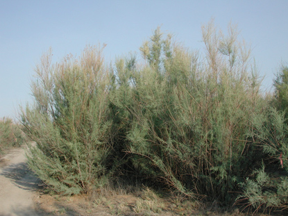
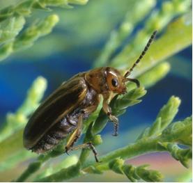
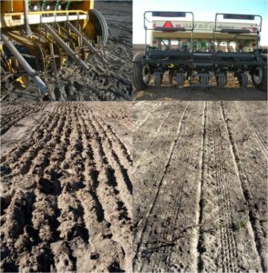
Cite this chapter
Pyke, D.A., Boyd, C.S. (2023). Manipulation of Rangeland Wildlife Habitats. In: McNew, L.B., Dahlgren, D.K., Beck, J.L. (eds) Rangeland Wildlife Ecology and Conservation . Springer, Cham. https://doi.org/10.1007/978-3-031-34037-6_5
Download citation
DOI: https://doi.org/10.1007/978-3-031-34037-6_5
Published:
Publisher Name: Springer, Cham
Print ISBN: 978-3-031-34036-9
Online ISBN: 978-3-031-34037-6
eBook Packages: Biomedical and Life SciencesBiomedical and Life Sciences (R0)