
Abstract
In marine spatial planning (MSP), the production of knowledge about marine-based activities is fundamental because it informs the process through which policies delineating the use of space are created and maintained. This paper revises our view of knowledge—developed during the mapping and planning processes—as the undisputed factual basis on which policy is developed. Rather, it argues that the construction, management, validation, and marginalisation of different types of knowledge stemming from different stakeholders or disciplinary approaches is at the heart of policy and planning processes. Using the case of fisheries-generated knowledge in the implementation of MSP, we contend that the fisheries data informing the MSP process are still very much streamlined to classical bio-economic metrics. Such metrics fall short of describing the plural and complex knowledges that comprise fisheries, such as localised social and cultural typologies, as well as the scale and dynamics, hence, providing incomplete information for the decision-making process of MSP. In this paper, we provide a way to move towards what we conceptualize as ‘Deep Knowledge’ and propose a model that brings together of the existing datasets and integrates socio-cultural data as well as complex spatiotemporal elements, to create dynamic rather than static datasets for MSP. We furthermore argue that the process of knowledge production and the building of the parameters of such datasets, should be based on effective stakeholder participation, whose futures depend on the plans that eventually result from MSP. Finally, we recommend that the ‘Deep Knowledge’ model is adopted to inform the process of knowledge production currently being undertaken in the diverse countries engaging in the MSP process. This will result in policies that truly reflect and address the complexities that characterise fisheries, and which are legitimized through a process of knowledge co-production.
Introduction
This article calls for a more nuanced and deliberate approach to producing knowledge about fisheries in the context of marine spatial planning (MSP), such that fisheries knowledge is more context-oriented and provides concrete detail of its uses, users and their needs. Fisheries are heterogeneous socio-ecological systems; some are artisanal and small-scale, while others involve large-scale industrialised practices. Accordingly, fishers have different livelihood needs (Pauly, 2006). Some depend on one type of fishing activity, while others target different species in different parts the year (Lloret et al., 2016). We also encounter the exploitation of the same ground by different segments (scale and fishing gear). This means that fishers are typically engaged in various forms of conflict. Typically, this occurs between small-scale and large-scale fishing enterprises, especially when the latter operate close to coastal fishing grounds and displace small-scale fisheries (Begossi et al., 2011). Tensions are also present amongst recreational fisheries targeting the same resources (Said et al., 2018) and between fishing and other marine activities, such as the discharge of pollutants from industrial areas (Micheli et al., 2013), the presence of aquaculture farms (Ertör & Ortega-Cerdà, 2015) or the invasion of alien species (Katsanevakis et al., 2014), all of which can radically change marine ecosystems. With increasing development, such as tourism, some fishers benefit from better markets due to higher demand for the local fish, while others might be facing marginalization in their fishing grounds due to the rise of coastal development and concomitant recreational activities and ecotourism (such as diving) (Said et al., 2017). All these factors highlight the multiple typologies of fisheries that exist at various scales including global, regional, national, local, port as well as at vessel and enterprise level. It also illustrates as well as the variations of challenges which fishers utilizing dissimilar fishing gear may face—or not—in the same geographic region.
Such dynamism also attests to the need of more critical social-scientific scholarship looking at how fisheries dependencies and needs are reflected in MSP, and the implications of MSP plans on ocean users’ livelihoods (Ntona, 2020). Given that MSP as a tool was primarily introduced to reduce the congestion, contestation and conflicts in the marine space (Douvere & Ehler, 2009), this dynamism needs to be recognized in any MSP process. Such information is necessary to provide planners with the fine detail they require to manage conflict between existing activities, as well as in the planning of prospective uses in already-congested marine zones. This article, calling for a spatial ‘deep knowledge’ perspective for fisheries in MSP is precisely about the urgent need of a new MSP lens and focus that can account for the diversity of fisheries. We argue that such ‘deep knowledge’ can be achieved by improving the technical considerations in mapping processes and through a more inclusive political approach that reflects the multiple voices both in the mapping and the planning processes.
Existing work has shown how MSP processes have not been sufficiently attentive to the voices of multiple stakeholders. They remain largely insensitive to the challenges and needs of fishers and fail to include the ideas and knowledge they have regarding the management of marine space (Flannery et al., 2018). This either happens because the spokespersons or representatives of the fishing communities do not actually represent the diversity of fishers in their constituencies and/or because fishers are ‘invited’ but not empowered to influence MSP policy. The latter is likely to happen when the process is controlled by scientists or bureaucrats commissioned as ‘authoritative experts’ to conduct the MSP. It is the appointment that makes the expert, not the other way round. These experts are likely to marginalise local knowledge as they identify which zones are utilised or reserved for practices such as fishing, recreation, infrastructure, energy and aquaculture. When led by experts and with limited input of fishers, mapping tends to privilege bio-economic data in a way that fails to represents the complexity of the way space is used, perceived and understood in practice (Janßen et al., 2018).
Here, we state why we need a broader and in-depth scope of the technical considerations in fisheries knowledge for marine spatial planning, and how this breadth and depth can be heightened through political considerations. We classify ‘deep knowledge’ as an iterative process at the confluence between technics and politics with the aim of ensuring future MSP remain critically aware of both the data they are collecting and ignoring. ‘Deep Knowledge’ urges MSP to ask why it focuses on certain forms of knowledge, how and why it should broaden its datasets, who should collect data, for whom and, ultimately, for which purpose. Such an iterative process for ‘deep knowledge’ represents a distinctive, and perhaps messier, trajectory than the linear data collection, mapping and planning process normatively adopted by policymakers and planners interested in securing a faster route towards marine developments. In this article, we engage with the governance process and the mandates in place to oversee the MSP development and argue for these to take a ‘Deep Knowledge’ perspective in their approach to policy. In its most ideal form, knowledge about marine activity should be accurately representative of the complex and multi-layered way it is understood in practice, and not reduced to its quantitative ecological or economic characteristics. For example, when mapping fishing, knowledge could include the type of fishing, the scale, its importance to the community, types of conflict with co-existing activities, levels of incompatibility between diverging practices and information on how these could be resolved through MSP.
In the next section, we take a socio-political geography perspective to explore the representation dilemmas and deficiencies posited by datasets currently used to describe fisheries in time and space. Successively, we present the concept of ‘Deep Knowledge’ as an alternative model of data collection with the aim of providing space for missing bodies of knowledge and reducing the current power imbalances in representation, interpretation and subsequent governance of the marine environment. Here, we push the idea that thinking from knowledge to data (context-dependent, political-laden etc. … ) is more appropriate than data to knowledge. Ultimately, in the “Reflexivity in knowledge production for MSP: maintaining the focus on ‘depth’” section, we call for continuous engagement with reflexivity in the planning and mapping processes, while maintaining our perspective on the importance of context-oriented models, rather than one-size-fits-all formulas for MSP knowledge production.
Fisheries data gaps and their implications on marine spatial planning
In MSP, the type of data collected, the process of collection and the interpretation of datasets are all fundamental components that determine the way by which we understand, perceive and, ultimately, manage fisheries within a spatial context. Simultaneously, the quality of our knowledge (how rich, broad and ‘thick’ it is—(Geertz 1973) is determined by the degree to which institutions/governments are willing to engage in open knowledge collection, as well as the extent to which stakeholders are allowed to influence the same process (Rydin, 2007). The process of collecting and analysing data—in the global north, at least—is predominantly technical in nature, initiated and controlled by ‘experts’ who have the knowledge-power (Foucalt 1972) to determine what constitutes valid data and, by extension, how fisheries end up represented in MSP. While these experts are not required to conform to a universalised process of knowledge production, there is a surprising uniformity in the way fisheries are taken into account in the global north. Studies show that in most countries the chosen angles and the associated metrics used to explain fisheries focus on fishing effort in relation to the value and distribution of fish (Janßen et al., 2018). In other words, the focus is on bio-economic data, and the economic and ecological aspects of fisheries, thus, become its key and core quality, used then in mapping and policy.
The main problem with this approach is that, as explained earlier, fisheries are complex phenomena and reducing them to bio-economic boundaries on the seascape brings forth representational dilemmas, which, in the long run may become political ones that affect the socio-ecological sustainability of conservation (Bertrand et al., 2007). When limiting fisheries to a unique bio-economic angle—ignoring the type, purpose, scale, equipment etc.—fishing becomes a monolithic activity of predation (Bastardie et al., 2014; Campbell et al., 2014). Needlessly said, such data is collected with economic purposes in mind and is entirely disconnected and deaf to fishing’s sociocultural aspects including the identity, wellbeing, history or territorial factors which is intrinsic to fishing communities (Coulthard, 2011). In other words, the social and cultural importance of fishing spaces—Lefebvre (Lefebvre, 1991) would call these “perceived” and “lived spaces”—are not present in the equation of bio-economic data collection. Consequently, the data cannot provide a clear and coherent picture of what fisheries are, what they look like, and what they mean to different people (Song et al., 2013), and the final MSP representation ends up being, essentially, a poor caricature of reality.
Since socio-cultural aspects of fisheries are not incorporated within the fisheries data systems, they are likely to be automatically (and legitimately) neglected from spatial plans. This happens even though such social ‘spaces’ and ‘places’ can help planners better assess the needs of different fishing segments, and evaluate the potential spatial trade-offs which can be borne by fishing communities should new uses be placed in their fishing grounds. It can be argued that the missing link of the social layer in MSP (St. Martin & Hall-Arber, 2008) can be attributed to the fact that there are no agreed-upon or defined methodologies for the collection of multiple forms of data for MSP. Thus, in the case of fisheries, the normative bio-economic approach remains the dominant one to inform the process (Flannery et al., 2018). In fact, in a worldwide investigation of 43 MSP initiatives in different countries, Trouillet (Trouillet, 2019) found that (i) 19 characterized fisheries only with classical bio-economics metrics of the fishing sciences and management; (ii) 21 simply don't map fisheries and (iii) only 3 demonstrate a will or an attempt to enlarge the scope of fisheries data collection to include social or cultural values (Nunavut in Canada, Oregon, USA and Mid-Atlantic, USA).
In the case of the European Union (EU) countries, the lack of detailed and context-based data about fisheries in MSP processes can be traced to the MSP Directive which does not require the Member States to collect new data but rather to use the best available fisheries datasets. Specifically, it states that countries should ‘organise the use of the best available data’ from existing repositories collected through Union legislation (Directive 2014/89/EU Art. 10). In the case of fisheries, such available and official data is the bio-economic type collected through the European Data Collection Framework (DCF) (see Table 1). Stated otherwise, authorities currently have no legal incentive or requirement to go beyond bio-economic data and invest in new systems of knowledge production for MSP. This means that under current EU mandates, our understanding and visualization of fisheries in MSP is conditioned by legislative structures that restrict a wider perspective of what constitutes fisheries in social, economic, cultural and political terms.
The EU MSP Directive does not specify the need for specific datasets to understand; for example conflicts in the marine zone, even though, as scholars note, such data on the competition for space and resources between marine sectors is necessary for MSP processes to be successful (Collie et al., 2013). It is highly unlikely that countries will invest in collecting data on fisheries specifically for MSP. In the North Sea, for example, MSP is considered a mere technocratic approach which does not implement sufficient effort to collect data about the local realities of fisheries (Jentoft & Knol, 2014). Similarly, in Malta, the process to assign new spaces as part of MSP does not include data collection about different fishing activities and the conflicts therein, with the result that fishing remains an invisible layer in a congested sea (Said et al., 2017). The UK is probably one of the few European cases where the authorities have pointed out the challenge of ‘the characterization of fisheries’ in different plans, but without suggesting any real solution other than underlining the importance to better incorporate fishers in the process to limit the problemFootnote 1 (HM Government, 2014).
One would hope that such localized and detailed data about fisheries—at the moment missing from mainstream data collection systems—would be gathered through the stakeholder participation process, which is a universal legal requirement in any MSP process. Using stakeholder involvement as a basis for data gathering, however, depends directly on the kind of stakeholder engagement implemented and the willingness to accommodate this new data in MSP. Knowledge integration barriers are frequently reported in the case of the MSP process, mostly because fishers do not normally hold epistemic scientific knowledge to be able to compete for the knowledge space in par with some dominant—or “expert”—players in the room (Trouillet et al., 2019). Although fishers are consulted in the process of knowledge production, their systems of knowledge, based on lived experiences and realities surrounding the fishing sector, do not readily fit into the systems of knowledge used by experts in the fishing sector. As a result, the streams of local/phronetic knowledge carried by community members are not intertwined or aligned to the metrics of the predominant epistemic data collection (Linke & Jentoft, 2014). In other words, by controlling how fisheries are described, the managerial-technological process automatically subjugates and silences forms of knowledge that it does not know how to validate, translate and analyse (Flannery et al., 2018).
The situation gets even more complex when we consider the fact that the MSP arena is saturated with different stakeholders, all contesting the space. These stakeholders have different levels of power, and can easily overcome rivals, including fishers (Coccoli et al., 2018). The capacity of fishers to participate and influence the MSP process depends a lot on the social space created by the authorities responsible to implement such interfaces. The way such platforms are run will determine how (or if) fishers’ perceptions on planning are incorporated into the process, prompting scrutiny on the validity of the knowledge production processes used to inform MSP (Stepanova & Bruckmeier, 2013). For example, in her examination on the role of knowledge in the planning process, Rydin (Rydin, 2007) criticizes the institutional structures that determine the production of knowledge for not being sufficiently open to integrate various types of ‘knowledge claims’ to inform the process. Effectively, in such complex circumstances, it is necessary to consider how knowledge is produced and how it is being used to inform fisheries in MSP. Herein lies our call for a ‘Deep Knowledge’ perspective for fisheries in MSP.
Deep knowledge for MSP: technical and political considerations for fisheries knowledge production
In order to effectively account for the incredibly diverse socio-ecological systems of fisheries worldwide, we must go beyond bio-economic metrics and expand our vision through ‘Deep Knowledge’. By ‘Deep Knowledge’, we mean a process which is informed by an assemblage of technical and socio-political knowledges of any kind that allows any group to be involved in democratic decisions at a highest level of participation. In this section, we focus on two key parameters that can provide deep knowledge for MSP processes: (i) ‘technical considerations’ of MSP knowledge production where we discuss the need for a wider lens to capture the ‘bigger’ picture of fisheries, including for example, implicit data pertaining to the social and cultural aspects of the fishery and (ii) ‘political considerations’ of MSP knowledge production to showcase the importance of an inclusive lens when capturing knowledge for both mapping and planning processes. In this paper, the terms ‘data’, information and ‘knowledge’ are aligned to Ackoff ‘s conceptualization, i.e. a sequence of successive operations where ‘data’ are collected; the ‘information’ deduced from data interpretation and several information types are combined to form ‘knowledge’ (Ackoff, 1989).
Moving from technical considerations towards deep knowledge, we contend that the approach should consist of clearly defined stages that seek to improve the data needed for mapping. In the literature, we are noticing a greater attention towards the need to develop such mapping applications, particularly with regard to the conventional fisheries metrics (e.g. (Bastardie et al., 2014; Natale et al., 2015)). Here, we argue that scientists responsible for mapping issues in the context of MSP should not start from biometric modelling but from the fundamentals of critical cartography and GIS where the technical scrutiny of mapping is meticulously and reflectively approached (e.g. (Crampton, 2001; Crampton & Krygier, 2006; Dalton & Thatcher, 2014)). Having said this, we also acknowledge that seeking precision becomes complicated when we acknowledge that data, metrics and maps are not neutral or value-free but are strongly influenced by subjective decisions and context-dependentFootnote 2. The best way forward is to remain explicitly inquisitive about who is involved in the mapping exercise and why. This allows diverse types of values to influence the process, without letting the epistemic scientific domains overrule other local knowledges. By this, we mean that the process to initiate mapping and to inform planning would benefit from more political questioning, taking into account the interests of all the groups of actors in the planning process. Below, we will define in further depth the technical and political considerations that would improve the knowledge production process for MSP processes.
Technical considerations: a wider lens for finer detail
The usefulness of maps is determined by their level of detail and resolution, and for MSP, sufficient resolution is necessary to represent what are both explicit and implicit details that characterise marine sectors, in this case fisheries. In this section, we produce a schematic to discuss the need for a wider perspective on fisheries to include other metrics including social and cultural data, as well as tackle the spatial-temporal elements (Fig. 1). Datasets should include information about culture, such as the presence of cultural heritage, traditions, beliefs and practices that constitute the fishing sector. Moreover, local attachment to space, as well as the identity of fishing communities and the social networks which determine the types of relations both at sea and onshore (e.g. with market traders) are all valuable facets that require recognition in MSP. Such data is necessary because social and cultural values are equivalently important as economic ones (Urquhart et al., 2013). Such data would be especially useful in the future, where policymakers would need to assign space to new uses in a way that does not put into conflict existing uses (Brown et al., 2015). Apart from reduced income for the fishing sector, impacts are likely to create ripple effects on other systems of the local economy, including sectors dependent on local fish products (restaurants, hotels, processing plants). With reduced socio-cultural traits in fishing harbours, the tourism sector also stands out to lose (Jacob et al., 2010).

Multi-component analysis to define fisheries. Source: authors
In terms of ‘scale’ of the fishing activity, we highlight the need for information on the fleet definition. its spatial extent, as well as the temporal resolution. This data would help us better understand what type of fishing is occurring—the gear involved, the species targeted, the scale of activity (small-scale, large-scale, recreational), relations between crew-members—and how fishers interplay within heterogeneous fishing fleets, and with other marine activities. By this, we mean taking into account the spatiotemporal scale of the activity to represent the frequency and intensity of use of a particular area by understanding (i) the time of operations, (ii) the space of operation, and (iii) the type of fishing activity as illustrated in Fig. 1. This can be challenging for boats that are not equipped with vessel monitoring systems (the number of which is quite high); however, other data such as interviews and participatory dynamic mapping could be used to provide these details, as will be further illustrated in the “Political considerations: an inclusive lens for deeper fisheries knowledge” section. Having such data would also enable an in-depth understanding of both existing conflict hotspots and potential compatibilities both within fishing and between fishing and other activities, including, for example, the potential for low-impact fisheries to sit in conservation areas as recognized by Jones (Jones, 2009) or the coexistence of fishing and diving (Habtemariam & Fang, 2016). This would then enable better planning of activities within the MSP, such as potential temporal multiple-use schemes, e.g. ‘dive during the day’ and ‘fishing during the night’ in areas contested by both diving and fishing.
Challenges like the one described above are common in coastal areas, which tend to be congested with competing activity, and which highlight the need for data that can help us decide which activities need to be abolished, and what can stay and under which terms. Through this multi-component analysis, it would be possible to anticipate winners and losers of possible planning scenarios, and determine either systems of compensation or alternative approaches to assigning space. Such data is very relevant as it maps out the complexity of what could later become stumbling blocks to the planning process due to lack of acceptance by the affected stakeholders. Through ‘Deep Knowledge’, we are able to construct model that are dynamic—just as real life at sea is—and thus counter the deficiencies of current static representation. This process would benefit from innovation of data types representation such as 3D or 4D mapping and geovisualisation tools which could better represent spatiotemporal variability of such multi-component datasets in the planning realm (Andrienko et al., 2008; Kraak & Ormeling, 2010; Resch et al., 2014; Roth, 2013; Salter et al., 2009; van den Brink et al., 2007).
Political considerations: an inclusive lens for deeper fisheries knowledge
Inclusivity and stakeholder participation is a fundamental component of any MSP process (Douvere & Ehler, 2009), and while many countries do implement participation strategies, there are still concerns about the degree to which political considerations shape this process. In this section, we highlight the need for broader political considerations in MSP in both the mapping (and data collection) and planning stages. We argue that mapping and planning processes should be regarded as two sides of the same coin if they are to achieve effective inclusiveness, thus giving legitimacy to the process that decides which information is collected and for which purpose. Drawing on Budhathoki et al. (Budhathoki et al., 2008) and Haklay’s (Haklay, 2013) recent work on mapping systems, we suggest revising the way participation structures are implemented and orchestrated to influence mapping and planning processes.
In Fig. 2, we conceptualize the different types of participation processes available. On one side, ‘Technical Hacking’ involves a technocratic approach determined by a process of ‘Official Mapping’ which generally aims at improving the characteristics of data and maps and their analysis, without really questioning how they fit into the ‘bigger’ plan. It is also in line with a broader movement of neogeography (Haklay, 2013) or citizen sciences contesting official producers of data, whether voluntarily or not. On the other hand, ‘Deep Democratization’ is conceptualized as a political approach configured around an overall plan, goal or strategy, and thus aims to cater for the interests of stakeholders by opening up the ability of social intervention beyond its usual field, in particular by bringing the technical aspects of data production closer to the political debates based on the data themselves. In simple words, the technical approach focuses on the means (mapping), while the political one is interested in the ends (planning).
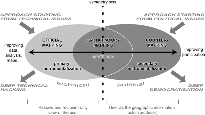
Finding a way between technical and political approaches of mapping
We contend that in many cases, official MSP is mostly delivered by deep ‘technical hacking’, where managerial-technical knowledge producers are given a mandate to map and plan fisheries, but not to influence, study, or intervene politically. Science, from this perspective, comes to appear as disconnected and free of politics. Here, we call for deeper knowledge that invites more political leverage and which thus incorporates multiple knowledges both in the mapping and planning stages. Specifically, we argue that governments (or their state-appointed experts) should not be alone in determining what legitimate and useful knowledge is. Rather, such responsibility should be shared with the different stakeholders including fishers, leading to the notion of ‘producer’ (Budhathoki et al., 2008). In other words, and referring to Fig. 2, the process requires a move from ‘Official Mapping’ as controlled by deep technical hacking to an inclusive one where the political and technical considerations are identified collectively, not separately. In practice, this would mean doing away with current two-stage systems whereby government first collects data and maps, then invites stakeholders to debate policy, denying the latter a ‘say’ on how maps are produced and with which knowledge types. Finding the middle-ground ‘participatory mapping’ would embrace both technical and political considerations, giving fishers (supported by scientists) the ability to collect data and to map their activities themselves, such that they can represent their stakes.
The experimental activity conducted by Trouillet et al. (Trouillet et al., 2019)—where fishers were invited to produce their own maps—testifies towards the success that inclusivity and deep knowledge can have when the political interface is allowed to play a role through enhanced participation in the technical build-up of data. Here, we see the role of fishers not as participants in the data collection process, or invited guests for debates on planning, but as ‘producers’ of knowledge in a process that captures and valorises diverse knowledges. In this sense, the ‘deep knowledge’ idea underlines the importance of merging the ability to participate with the ability to hold knowledge, and to communicate it. Through the right interface, the knowledges of fishers are mobilized to a level that can be interpreted and incorporated within the decision-making framework (Madrigal-Ballestero et al., 2013). By providing the means to fishers to actually become the owners and leaders of their own data process, they could become empowered not only to determine the type, style and width of the data but also to use this tool as a political instrument to partake in decision-making fora with their own ‘scientific’ data (Trouillet et al., 2019).
Through their participation, fishers can provide mapping of their metier uses, define spatial uses and frequency, identify zones of local social, cultural and economic importance, and flag information about hotspots and conflicts that would require specific resolution strategies in the milieu of marine spatial policy planning (De la Cruz Modino & Pascual-Fernández, 2013). The particularities of certain conflicts—such as those between different activities, or inter-sectoral tensions between fishers using different gear—are crucial, for they contribute to the ‘bigger picture’ and illuminate the challenges and resilience of fisheries (Said et al., 2017). Such data could also simulate potential access implications that fishers could face due to increased activities competing for maritime space, as well as the potential impact of displaced fishing efforts to neighbouring fishing grounds. Failure to recognize current and impending realities can lead to spatial plans that do not misfit, misrepresent, and misunderstand the real context they mean to govern. For example, in the marine planning of marine protected areas (MPA) in different countries, fishers ended up squeezed between industrial fishers on the one and conservation objectives on the other, leaving fishermen no other option but to resist governmental policy in bid to pursue their livelihoods (Begossi et al., 2011; Said et al., 2017; Lopes et al., 2015). Being cognizant of these multiple knowledge layers makes planners better equipped to reflect on the deeper ramifications that lie beneath the surface of the spatial plan, and to thus to make ‘informed’ MSP decisions.
Reflexivity in knowledge production for MSP: maintaining the focus on ‘depth’
Our critique of the current knowledge production systems used for fisheries, and our call for deep knowledge to inform the MSP process, is also an invitation to seek approach the mapping and planning of fisheries in the context of MSP from a new critical direction. This, in turn, stresses awareness of the way data are represented and used by different agents in the planning process. In this sense, deep knowledge requires constant reflexive analysis about data collection procedures and their relevance for knowledge production to inform the planning process. By this, we mean that any MSP should question the very basics of knowledge production. Namely, it must question itself about (i) the process by which different types of knowledge are hierarchically arranged (e.g. conventional scientific knowledge as opposed to and as superior to fishers knowledge), (ii) the ‘place’ where knowledge is constructed (in-situ production of knowledge, i.e. by fishers themselves, vs. ex situ, i.e. by other people than the holders, generally scientists, through processes of sampling, statistical analysis, scientific rhetoric, etc.), (iii) the extent to which various kinds of knowledge can coexist productively, that is the degree to which groups are able to incorporate others’ knowledge.
All these factors determine and influence the outcome of the different MSP processes including (i) the type(s) of data collected, (ii) how the information from the data is analysed and distilled into knowledge, and (iii) the purpose for which the knowledge is then used (Ackoff, 1989). Reflecting on the various stages of this process could open up new ways of recognizing what could be ‘taken-for-granted’ procedures in MSP, and highlights gaps and bias. We contend that delving into the rationale driving various choices is very important. This is particularly important when, for example, particular mapping processes ultimately determine the way data is collected (and ignored) and compiled. Mapping outputs are likely to change according to the political purpose of fisheries planning, regardless of whether such strategy is explicit or not, such as when the mapping of core fishing grounds ‘implicitly’ pushes fisheries off the plan. In this respect, much of the question is related to the very motive of MSP; who is driving it, and who says what goes where and why. For example, biologists might be focusing on protecting habitats and so might map the impact of fisheries on protected areas, whilst anthropologists might privilege the role certain areas play in the reproduction of fishers’ culture, values and identity. While both are mapping the same zones within the umbrella of MSP, the questions that drive their framing and data collection vary in scope and focus. Thus, whatever the equation, formulae or narrative used to calculate or explain such figures, the choice of metrics and other spatial data repositories remain the decisive factor that determines how the story is told and with which timeframe (Amoroso et al., 2018).
Hence, questioning the purpose of the data mapping exercise is important because although there is no right or wrong answer as to which data to collect, of which data to collect and for what purpose, the data produced automatically becomes the ‘objective’ one used to inform the MSP process. This also relates to the questioning of the link between the planning and mapping exercises involved in MSP, and why these should constantly be seen in regard to each other. Ideally, mapping (including data, metrics etc.) should be driven by a particular purpose and within a specific context, (Carton, 2007; Dühr, 2007; Noucher et al., 2019) and thus should never be seen as an end in itself. Instead, it should be seen as a means of producing knowledge to inform the process. By this, we mean that when looking at fisheries knowledge production in MSP mapping process, one should also question the very purpose of mapping and planning as this will condition the mapping process itself and the technical choices that will be made for the exercise. Ultimately, the success of the MSP process would be determined by the level to which it is informed by as many technical and socio-political systems of knowledge as possible, which in turn allows stakeholders to be recognised and involved in democratic decision at the highest level of participation. The procedure by which data appear as objective tends to be all the more complete (and problematic) when reflexive inquiry on the ideologies driving data production is not incorporated. Moreover—and more central to the map discussion—is the question of how one ends up ‘on the map’, how knowledge becomes visible and thus have a chance to influence political agenda (Trouillet, 2019).
Here, our focus is mostly on those who are mandated to implement an MSP plan, and thus are leading the knowledge production process. As leaders, they are also required to ensure sufficient representation of the fishing segment by implementing stakeholder identification exercises to recognize the diversity across users. Such a role could be facilitated by both the fishing sector itself or by institutions responsible for fisheries research management; the latter are likely better acquainted with the various fishing sectors and better equipped to conduct a wider stratified analysis of the diversities in the sector. A needs-and-capacities analysis of different fishers is also important, especially when they are required to deal with technical jargon (e.g. biological datasets or legal texts) (Linke & Jentoft, 2014). Ultimately, experts should also be aware of their own values and subjective views when deploying their ideas and presenting facts in the process. Here one can question the type of knowledges which are determined by one’s systems of knowledge production, the scientific methods involved and the metrics compiled, which although being epitomized as neutral and objective, are ultimately determined by what the expert-compiled datasets and metric systems can represent (or not) as knowledge (Nursey-Bray et al., 2014).
Conclusion
Although mapping and planning tools able produce knowledge about the fisheries sector for the MSP process are available, the depth of the knowledge produced remains a universal concern. This article contributes to the growing literature (see (Shucksmith et al., 2014) addressing urgent issues in MSP processes, challenges which predominantly stem from the difficulty to account for the complexity and diversity of fisheries globally. In this article, we argue that—at a minimum—we need to question the relevance of the fisheries metrics used in the context of MSP and recognise inclusivity issues involving non-scientific knowledge in MSP, given the power asymmetries and inequality normally associated with top-down managerial-technological methods applied in MSP (Flannery et al., 2018). Only through such analysis can we question the quality of the process and type of knowledge production, and be in a position to inform what challenges exist, what can be improved, and how.
Fisheries are diverse and they are part of interconnected systems. They are affected by shifts in the stocks, in markets, in social fabric, and also by the community values that inform them. These are hard to pin down with existing MSP tools. Moreover, given their relatively low contribution to national wealth, fisheries do not get as much attention in the promulgation of policies in marine planning (Jentoft, 2017). Whilst legislative marine boundaries and zoning are established for the implementation of various activities—including aquaculture, oil and gas, tourism and swimming zones—fisheries, especially of a small-scale nature, get a back seat (Said et al., 2017; Jentoft & Knol, 2014). In many cases, they do not get a seat at all; fisheries remain spatially and legally unrecognized, their fluidity makes their fishing grounds a ‘non-occupied zone’ which can be easily handed over to other stakeholders with higher economic potential, such as oil exploration (Bennett et al., 2015).
With the concurrent plans for blue economy—broadly defined as a global push for the creation of economic growth through a range of marine-based industries such as aquaculture, energy and tourism (Eikeset et al., 2018)—the situation does not look promising, at least in E.U. context. Here, the fishing sector is not envisaged as one of the five key pillars of the EU Blue Growth strategy on the argument that growth from fisheries cannot happen with the current overexploited status of fish stocks (Blomeyer et al., 2017; Hadjimichael, 2018; Said & Chuenpagdee, 2019). It is highly probable that the Blue Growth strategy will have a huge influence on the MSP processes, at least in some regions (e.g. (Jones et al., 2016)). As a political tool, it will be used to allocate space for ‘growth-generating’ marine sectors. This may well be yet another development that evicts fishers from their fishing grounds. It is still not known how and whether fishers are/will be included in the conversations on Blue Growth plans, and thus how their knowledge will feature in the MSP process. This all depends on how MSP is used and the motives that underline it, and whether there is real determination to put fisheries on the map and make them visible, or if it is used as a tool to provide the interface that legitimizes the process of ‘grabbing’ to provide sea-space for other marine activities (Said & MacMillan, 2019).
Such scenarios are determined by the country’s priorities and how these intentions are supported and brought in line with legal provisions. In the EU, for example, the Member States are required to implement marine spatial plans to promote ‘the sustainable growth of maritime economies, the sustainable development of marine areas and the sustainable use of marine resources’ (Directive 2014/89/EU). If applied correctly, MSP can be used to truly represent fisheries diversity through enhanced data systems, as well as provide the space for the stakeholders to inform the planning process (Pomeroy & Douvere, 2008). This depends on regulatory bodies scrutinising their data collection systems and stakeholder participation process to provide space for democratic data-driven MSP.
Notes
Evidence Point 434 on page162 states: “The lack of uniformity and stakeholder consensus regarding fisheries data combined with the difficulties in predicting the future of fisheries, makes formulating prescriptive marine plan policies for this sector a challenge. The Marine Management Organisation will continue to work closely with the fishing sector to assess how this challenge might be addressed in the future.”
In fact, the word ‘context’ may be inappropriate as far as the very idea of ‘context’ is somehow counter-intuitive if one consider technological artefacts as actors in social relations (Callon & Ferrary, 2006), such as in the actor-network theory.
References
Ackoff, R.L. 1989. From data to wisdom. Journal of Applied Systems Analysis 16, 3: –9.
Amoroso, R.O., C.R. Pitcher, A.D. Rijnsdorp, R.A. McConnaughey, A.M. Parma, P. Suuronen, et al. 2018. Bottom trawl fishing footprints on the world’s continental shelves. Proceedings of the National Academy of Sciences of the United States of America 115: E10275–E10282. https://doi.org/10.1073/pnas.1802379115.
Andrienko, G., N. Andrienko, J. Dykes, S.I. Fabrikant, and M. Wachowicz. 2008. Geovisualization of dynamics, movement and change: key issues and developing approaches in visualization research. Information Visualization 7 (3–4): 173–180. https://doi.org/10.1057/IVS.2008.23.
Bastardie, F., J.R. Nielsen, O.R. Eigaard, H.O. Fock, P. Jonsson, and V. Bartolino. 2014. Competition for marine space: modelling the Baltic Sea fisheries and effort displacement under spatial restrictions. ICES Journal of Marine Science 3 (1): 824–840. https://doi.org/10.1093/icesjms/fsu215.
Begossi, A., P.H. May, P.F. Lopes, L.E.C. Oliveira, V. da Vinha, and R.A.M. Silvano. 2011. Compensation for environmental services from artisanal fisheries in SE Brazil: policy and technical strategies. Ecological Economics 71: 25–32. https://doi.org/10.1016/j.ecolecon.2011.09.008.
Bennett, N.J., H. Govan, and T. Satterfield. 2015. Ocean grabbing. Marine Policy 57: 61–68. https://doi.org/10.1016/J.MARPOL.2015.03.026.
Bertrand, S., A. Bertrand, R. Guevara-Carrasco, and F. Gerlotto. 2007. Scale-invariant movements of fishermen: the same foraging strategy as natural predators. Ecol Soc Am 17 (2): 331–337. https://doi.org/10.1890/06-0303.
Blomeyer R & Sanz FJG: Kim Stobberup, María Dolores Garza Gil, Aude Stirnemann-Relot, Arthur Rigaud, Nicolò Franceschelli, R.B., 2017. Small-scale fisheries and Blue Growth in the EU.
Brown, G., C.M. Raymond, and J. Corcoran. 2015. Mapping and measuring place attachment. Applied Geography 57: 42–53. https://doi.org/10.1016/j.apgeog.2014.12.011.
Budhathoki, N., B. Bruce, and N. Nedovic-Budic. 2008. Reconceptualizing the role of the user of spatial data infrastructures. GeoJournal 72 (3-4): 149–160. https://doi.org/10.1007/s10708-008-9189-x.
Callon, M., and M. Ferrary. 2006. Les réseaux sociaux à l’aune de la théorie de l’acteur-réseau. Sociologies pratiques 2 (13): 37–44. https://doi.org/10.3917/sopr.013.0037.
Campbell, M.S., K.M. Stehfest, S.C. Votier, and J.M. Hall-Spencer. 2014. Mapping fisheries for marine spatial planning: gear-specific vessel monitoring system (VMS), marine conservation and offshore renewable energy. Marine Policy 45: 293–300. https://doi.org/10.1016/j.marpol.2013.09.015.
Carton, L.J., 2007. Map making and map use in a multi-actor context: spatial visualizations and frame conflicts in regional policymaking in the Netherlands. PhD dissertation. Delft University of Technology, pp. 358.
Coccoli, C., I. Galparsoro, A. Murillas, K. Pınarbaşı, and J.A. Fernandes. 2018. Conflict analysis and reallocation opportunities in the framework of marine spatial planning: a novel, spatially explicit Bayesian belief network approach for artisanal fishing and aquaculture. Marine Policy 94: 119–131. https://doi.org/10.1016/j.marpol.2018.04.015.
Collie, J.S., W.L. Vic Adamowicz, M.W. Beck, B. Craig, T.E. Essington, D. Fluharty, J. Rice, and J.N. Sanchirico. 2013. Marine spatial planning in practice. Estuarine, Coastal and Shelf Science 117: 1–11. https://doi.org/10.1016/j.ecss.2012.11.010.
Coulthard, S. 2011. More than just access to fish: the pros and cons of fisher participation in a customary marine tenure (Padu) system under pressure. Marine Policy 35: 405–412. https://doi.org/10.1016/j.marpol.2010.11.006.
Crampton, J.W. 2001. Maps as social constructions: power, communication and visualization. Progress in Human Geography 25 (2): 235–252. https://doi.org/10.1191/030913201678580494.
Crampton, J.W., and J. Krygier. 2006. An introduction to critical cartography. ACME: Int J Crit Geogr 4 (1): 11–33 https://www.acme-journal.org/index.php/acme/article/view/723.
Dalton, C., J. Thatcher. 2014. What does a critical data studies look like, and why do we care? Seven points for a critical approach to ‘big data’. Society and Space open site. http://societyandspace.org/2014/05/12/what-does-a-critical-data-studies-look-like-and-why-do-we-care-craig-dalton-and-jim-thatcher/
De la Cruz Modino, R., and J.J. Pascual-Fernández. 2013. Marine protected areas in the Canary Islands – improving their governability. In Governability of Fisheries and Aquaculture, ed. M. Bavinck, R. Chuenpagdee, S. Jentoft, and J. Kooiman, 219–240. Dordrecht: Springer Netherlands.
Douvere, F., Ehler, C., 2009. Marine spatial planning : The Guide 1–36.
Dühr, S. 2007. The visual language of spatial planning. exploring cartographic representations for spatial planning in Europe, 212. London: Routledge.
Eikeset, A.M., A.B. Mazzarella, B. Davíðsdóttir, D.H. Klinger, S.A. Levin, E. Rovenskaya, and N.C. Stenseth. 2018. What is blue growth? The semantics of “Sustainable Development” of marine environments. Marine Policy 87: 177–179. https://doi.org/10.1016/j.marpol.2017.10.019.
Ertör, I., and M. Ortega-Cerdà. 2015. Political lessons from early warnings: marine finfish aquaculture conflicts in Europe. Marine Policy 51: 202–210. https://doi.org/10.1016/j.marpol.2014.07.018.
Flannery, W., N. Healy, and M. Luna. 2018. Exclusion and non-participation in marine spatial planning. Marine Policy 88: 32–40. https://doi.org/10.1016/J.MARPOL.2017.11.001.
Foucault, M. 1972. The archeology of knowledge and the discourse on language. Pantheon Books, New York.
Geertz, C. 1973. Thick description: toward an interpretive theory of culture. (C. Geertz, Ed.), The Interpretation of Cultures. New York: FontanaPress.
Habtemariam, B.T., and Q. Fang. 2016. Zoning for a multiple-use marine protected area using spatial multi-criteria analysis: the case of the Sheik Seid Marine National Park in Eritrea. Marine Policy 63: 135–143. https://doi.org/10.1016/j.marpol.2015.10.011.
Hadjimichael, M. 2018. A call for a blue degrowth: unravelling the European Union’s fisheries and maritime policies. Marine Policy 94: 158–164. https://doi.org/10.1016/j.marpol.2018.05.007.
Haklay, M. 2013. Neogeography and the delusion of democratisation. Environment & Planning A 45 (1): 55–69. https://doi.org/10.1068/a45184.
HM Government, 2014. East inshore and east offshore marine plans. London, UK.
Jacob, S., P. Weeks, B.G. Blount, and M. Jepson. 2010. Exploring fishing dependence in gulf coast communities. Marine Policy 34: 1307–1314. https://doi.org/10.1016/j.marpol.2010.06.003.
Janßen, H., F. Bastardie, M. Eero, K.G. Hamon, H.H. Hinrichsen, P. Marchal, J.R. Nielsen, O. Le Pape, T. Schulze, S. Simons, L.R. Teal, and A. Tidd. 2018. Integration of fisheries into marine spatial planning: Quo vadis? Estuarine, Coastal and Shelf Science 201: 105–113. https://doi.org/10.1016/j.ecss.2017.01.003.
Jentoft, S. 2017. Small-scale fisheries within maritime spatial planning: knowledge integration and power. Journal of Environmental Policy and Planning 19 (3): 266–278. https://doi.org/10.1080/1523908X.2017.1304210.
Jentoft, S., Knol, M., 2014. Marine spatial planning: risk or opportunity for fisheries in the North Sea? Maritime Studies 13 (1). https://doi.org/10.1186/2212-9790-13-1
Jones, P.J.S. 2009. Equity, justice and power issues raised by no-take marine protected area proposals. Marine Policy 33: 759–765. https://doi.org/10.1016/j.marpol.2009.02.009.
Jones, P.J.S., L.M. Lieberknecht, and W. Qiu. 2016. Marine spatial planning in reality: Introduction to case studies and discussion of findings. Marine Policy 71: 256–264. https://doi.org/10.1016/j.marpol.2016.04.026.
Katsanevakis, S., M. Coll, C. Piroddi, J. Steenbeek, F. Ben Rais Lasram, A. Zenetos, and A.C. Cardoso. 2014. Invading the Mediterranean Sea: biodiversity patterns shaped by human activities. Frontiers in Marine Science 1: 1–11. https://doi.org/10.3389/fmars.2014.00032.
Kraak, M.J., Ormeling, F. 2010. Cartography: visualization of geospatial data. Routledge, 3rd ed.
Lefebvre, H., 1991. The social production of space, First. ed. Wiley-Blackwell.
Linke, S., and S. Jentoft. 2014. Exploring the phronetic dimension of stakeholders’ knowledge in EU fisheries governance. Marine Policy 47: 153–161. https://doi.org/10.1016/j.marpol.2013.10.010.
Lloret, J., I.G. Cowx, H. Cabral, M. Castro, T. Font, J.M.S. Gonçalves, A. Gordoa, E. Hoefnagel, S. Matić-Skoko, E. Mikkelsen, B. Morales-Nin, D.K. Moutopoulos, M. Muñoz, M.N. dos Santos, P. Pintassilgo, C. Pita, K.I. Stergiou, V. Ünal, P. Veiga, and K. Erzini. 2016. Small-scale coastal fisheries in European Seas are not what they were: Ecological, social and economic changes. Marine Policy 98: 176–186. https://doi.org/10.1016/j.marpol.2016.11.007.
Lopes, P.F.M., S. Pacheco, M. Clauzet, R.A.M. Silvano, and A. Begossi. 2015. Fisheries, tourism, and marine protected areas: conflicting or synergistic interactions? Ecosystem Services 16: 333–340. https://doi.org/10.1016/j.ecoser.2014.12.003.
Madrigal-Ballestero, R., A. Schlüter, and M. Claudia Lopez. 2013. What makes them follow the rules? Empirical evidence from turtle egg harvesters in Costa Rica. Marine Policy 37: 270–277. https://doi.org/10.1016/j.marpol.2012.05.009.
Micheli, F., B.S. Halpern, S. Walbridge, S. Ciriaco, F. Ferretti, S. Fraschetti, R. Lewison, L. Nykjaer, and A.A. Rosenberg. 2013. Cumulative human impacts on Mediterranean and Black Sea marine ecosystems: assessing current pressures and opportunities. PLoS One 8: e79889. https://doi.org/10.1371/journal.pone.0079889.
Natale, F., N. Carvalho, and A. Paulrud. 2015. Defining small-scale fisheries in the EU on the basis of their operational range of activity. The Swedish fleet as a case study. Fisheries Research 164: 286–292. https://doi.org/10.1016/j.fishres.2014.12.013.
Noucher, M, Hirt, I., Arnauld de Sartre, X., 2019. Mises en chiffres, mises en cartes, mises en ordre du monde. EspacesTemps.net, https://doi.org/10.26151/espacestemps.net-ny99-7659
Ntona, M., 2020. Regulating oceanic imaginaries: the legal construction of space , identities , relations and epistemological hierarchies within marine spatial planning. Marit. Stud.
Nursey-Bray, M.J., J. Vince, M. Scott, M. Haward, K. O’Toole, T. Smith, N. Harvey, and B. Clarke. 2014. Science into policy? Discourse, coastal management and knowledge. Environmental Science & Policy 38: 107–119. https://doi.org/10.1016/j.envsci.2013.10.010.
Pauly, D. 2006. Major trends in small-scale marine fisheries, with emphasis on developing countries, and some implications for the social sciences. Marit Stud 4: 7–22.
Pomeroy, R., and F. Douvere. 2008. The engagement of stakeholders in the marine spatial planning process. Marine Policy 32: 816–822. https://doi.org/10.1016/j.marpol.2008.03.017.
Resch, B., R. Wohlfahrt, and C. Wosniok. 2014. Web-based 4D visualization of marine geo-data using WebGL. Cartography and Geographic Information Science 41 (3): 235–247. https://doi.org/10.1080/15230406.2014.901901.
Roth, R.E. 2013. Interactive maps: What we know and what we need to know. JOSIS 6: 59–115. https://doi.org/10.5311/JOSIS.2013.6.105.
Rydin, Y. 2007. Re-examining the role of knowledge within planning theory. Planning Theory 6 (1): 52–68. https://doi.org/10.1177/1473095207075161.
Said, A., and R. Chuenpagdee. 2019. Aligning the sustainable development goals to the small-scale fisheries guidelines: a case for EU fisheries governance. Marine Policy 107: 103599. https://doi.org/10.1016/j.marpol.2019.103599.
Said, A., and D. MacMillan. 2019. ‘Re-grabbing’ marine resources: a blue degrowth agenda for the resurgence of small-scale fisheries in Malta. Sustainability Science 15: 91–102. https://doi.org/10.1007/s11625-019-00769-7.
Said, A., D. MacMillan, M. Schembri, and J. Tzanopoulos. 2017. Fishing in a congested sea: What do marine protected areas imply for the future of the Maltese artisanal fleet? Applied Geography 87: 245–255. https://doi.org/10.1016/j.apgeog.2017.08.013.
Said, A., D. MacMillan, and J. Tzanopoulos. 2018. The contested commons: the failure of EU fisheries policy and governance in the Mediterranean and the crisis enveloping the small-scale fisheries of Malta. Frontiers in Marine Science 5: 300. https://doi.org/10.3389/FMARS.2018.00300.
Salter, J.D., C. Campbell, M. Journeay, and S.R.J. Sheppard. 2009. The digital workshop: exploring the use of interactive and immersive visualisation tools in participatory planning. Journal of Environmental Management 90 (6): 2090–2101. https://doi.org/10.1016/j.jenvman.2007.08.023.
Shucksmith, R., L. Gray, C. Kelly, and J.F. Tweddle. 2014. Regional marine spatial planning – the data collection and mapping process. Marine Policy 50: 1–9. https://doi.org/10.1016/j.marpol.2014.05.012.
Song, A.M., R. Chuenpagdee, and S. Jentoft. 2013. Values, images, and principles: what they represent and how they may improve fisheries governance. Marine Policy 40: 167–175.
St. Martin, K., and M. Hall-Arber. 2008. The missing layer: geo-technologies, communities, and implications for marine spatial planning. Marine Policy 32: 779–786. https://doi.org/10.1016/j.marpol.2008.03.015.
Stepanova, O., and K. Bruckmeier. 2013. The relevance of environmental conflict research for coastal management. A review of concepts, approaches and methods with a focus on Europe. Ocean and Coastal Management 75: 20–32. https://doi.org/10.1016/j.ocecoaman.2013.01.007.
Trouillet, B. 2019. Aligning with dominant interests: the role played by geo-technologies in the place given to fisheries in marine spatial planning. Geoforum. 107: 54–65. https://doi.org/10.1016/j.geoforum.2019.10.012.
Trouillet, B., L. Bellanger-Husi, A. El Ghaziri, C. Lamberts, E. Plissonneau, and N. Rollo. 2019. More than maps: providing an alternative for fisheries and fishers in marine spatial planning. Ocean and Coastal Management 173: 90–103. https://doi.org/10.1016/j.ocecoaman.2019.02.016.
Urquhart, J., T. Acott, and M. Zhao. 2013. Introduction: social and cultural impacts of marine fisheries. Marine Policy 37: 1–2. https://doi.org/10.1016/j.marpol.2012.04.007.
van den Brink, A., R.J.A. van Lammeren, R.J. van de Velde, and S. Däne, eds. 2007. Imaging the future: geo-visualisation for participatory spatial planning in Europe. Mansholt publication series, 3. Wageningen: Wageningen Academic Publishers.
Author information
Authors and Affiliations
Corresponding author
Ethics declarations
Conflict of interest
The authors declare that they have no conflict of interest.
Additional information
Publisher’s note
Springer Nature remains neutral with regard to jurisdictional claims in published maps and institutional affiliations.
Rights and permissions
Open Access This article is licensed under a Creative Commons Attribution 4.0 International License, which permits use, sharing, adaptation, distribution and reproduction in any medium or format, as long as you give appropriate credit to the original author(s) and the source, provide a link to the Creative Commons licence, and indicate if changes were made. The images or other third party material in this article are included in the article's Creative Commons licence, unless indicated otherwise in a credit line to the material. If material is not included in the article's Creative Commons licence and your intended use is not permitted by statutory regulation or exceeds the permitted use, you will need to obtain permission directly from the copyright holder. To view a copy of this licence, visit http://creativecommons.org/licenses/by/4.0/.
About this article

Cite this article
Said, A., Trouillet, B. Bringing ‘Deep Knowledge’ of Fisheries into Marine Spatial Planning. Maritime Studies 19, 347–357 (2020). https://doi.org/10.1007/s40152-020-00178-y
Received:
Accepted:
Published:
Issue Date:
DOI: https://doi.org/10.1007/s40152-020-00178-y