
Abstract
In the Merjan oil field (Central Iraq), the previous 2D seismic interpretation of subsurface geometry had been revealed mound facies which was interpreted as large carbonate buildup within carbonate Najmah formation of Jurassic age. The exploration well (Me-1) had been drilled depending on these results, but carbonate buildup did not exist. The current research provides new sight to interpretation of this feature in the Jurassic succession. High accurate 3D seismic reflection data have been used. Two scenarios have been presented to interpretation. Scenario (A) includes tectono stratigraphic study which finds out that mound shape is due to fault system and tectonic activity during the sedimentation which led to the formation of a graben structure and after sedimentation led to tectonic inversion. These events cause the camouflage stratigraphic feature. Scenario (B) relies on conversion of seismic section from time into depth domain using appropriate velocity model. The resultant seismic depth section helps to present another seismic analysis of feature. The proposed structural model according to the depth section interpretation is anticlinal fault-bend fold. Quantitative geometric relationships between fault and fold shapes were established. Both scenarios explain the causes of the formation of the mound seismic facies which was previously interpreted as carbonate buildup. In conclusion, the stratigraphy interpretation based on 2D data might be very risky and 3D seismic is a must for exploration of stratigraphy traps.
Introduction
Structural characteristic of extensional basin plays an important role in geometry of sedimentary fill and mechanism of hydrocarbon entrapment (Benn et al. 2006; Benvenuti 2003; Tim et al. 2010; Ferentions et al. 2002; De Batist 2011). Seismic data are a powerful tool to make seismic stratigraphic and seismic geomorphology analysis (Zeng and Hentz 2004; Posamentier 2001, 2004; Wood 2007; Anju and Dhananjai 2015). Seismic geomorphology was defined by Posamentier et al. (2007) as “the application of analytical techniques pertaining to the study of landforms and to the analysis ancient, buried geomorphic surface as imaged by three-dimensional (3D) seismic data”. The integration between seismic geomorphology and sequence stratigraphy leads to better understanding of the structural environment that is related to forces forming structural style and basin evolution processes. Structural framework helps in predicting the spatial–temporal distribution of sedimentary facies under a sequence stratigraphic framework (Zhu et al. 2016).
The current study deals with a case related to structural and sequence stratigraphic framework. The case is for Merjan oil field in Iraq (Fig. 1).

The Merjan–West Kifl oil fields were discovered by the reconnaissance of two-dimensional seismic survey of Karbala—west Baghdad area in the late 1970s. Foreign Company had been interpreted the data in the 1980. The result of the interpretation is the announcement of the existence of large of stratigraphic body seated within the Najmah Formation (U. Jurassic) (Fig. 2). It is interpreted as ancient coral reef, and the field for this reason is called Merjan (Arabic word for the English word coral reef); according to this statement, the National Oil Company has decided drilling work to target the coral reef. Well Merjan-1 was drilled as an exploration well between May and August 1983 to a depth of 2777 m. The well bottomed in the middle Jurassic Sargelu Formation. The results were disappointing. All that found is calcareous clays with non-economic heavy oil indicators. The drill omits all considerations except the stratigraphic body, where it was drilled on structural syncline. The Me-1 well is located at the shot point number 1340 on the seismic line BW-2. A specialist of Sedimentology Group (SG) was requested to undertake an environmental and litho-facies analysis of well cuttings and core chips from the Me-1 well with an emphasis on the presence of indicators of reef facies proximity. But the SG report reveals that there is no indication of a reef or proximity to a reef in the U. Jurassic sediments penetrated by the Me-1 well. No reef building organisms were encountered in the limestone for the lower part of the interval. Extensive digenesis obscures the original sediment composition in the upper part of the section (Frydl and Larson 1984). Many studies have been conducted on the area and have concluded that the area is affected by major normal faults with N–S trend direction and minor faults observed using the instantaneous phase and frequency sections. These studies are focused only on the Upper Cretaceous rocks and Tertiary and did not take into account the lower Cretaceous and Jurassic sequences (Khorshid et al. 2016a, b).

2D seismic section (Bw2) of fold coverage (24) illustrates the mound configuration that previously interpreted as carbonate build up by foreign company in 1982
Fadhil and Al-Rahim (2019) used chaos and ant track attributes to recognize the faulting systems and subtle faults of a Jurassic–Cretaceous Sedimentary Packages in the area. They determined seven major normal faults affect the area. The problem remains unsolved since no hydrocarbon was produced from the Najmah carbonate Formation (O.E.C. 2014).
In 2013, 3D seismic data for the Merjan area were acquired with 380 full-fold coverage. In the present study, we will offer new sight to the interpretation using these 3D seismic data in a new manner of dealing in term of tectono stratigraphic framework and seismic structural analysis for the Jurassic succession in the Merjan field. Also, there is re-interpretation of seismic feature in Najmah Formation. The specific design used in 3D seismic acquisition for Merjan field helps to obtain good quality of recorded data. The fold coverage is high (380) and permits to investigate the requested answers.
Location and geological setting
The Merjan–West Kifl oil fields are located in the middle of Iraq, west of the Euphrates River within Al-Najaf–Karbala province approximately (60–70 km) to the south of Baghdad (Fig. 1a).
From the tectonic side of view and according to the division of the tectonic setting of Iraq (Fig. 1b), the study area lies in the western boundaries of the Mesopotamian basin (near platform flank of Mesopotamian foredeep adjacent to the northeastern slope of African-Arabian platform. Merjan–West Kifl oil fields lie in the critical area between the stable and unstable shelf (GEOSURV 1996). Abu-Jir Fault Zone separates a boundary between stable and unstable shelves.
Abu-Jir Fault Zone forms an expressive linear feature across the Iraqi territory for about 600 km that is clearly visible from satellite images. This zone consists of several NW–SE trending faults that extend from Anah Graben, across the Euphrates River valley to Hit, Awasil, Abu-Jir, Shithatha, along the western side of the Euphrates River through Karbala, Al-Najaf and Samawa to meet Al-Batin lineament west Basrah and northwest Kuwait (Fouad 2007). For more details about Abu-Jir Fault in the area, it can be returned to Alhadithi and Salih (2017).
During the period of L. Jurassic-Albian (200-97ma), the Arabian plate was dominated by post-rift thermal sag generating a passive margin to the northwest and northeast. The Neo-Tethys Ocean continues to spread to the northeast and the Mediterranean in the north began to open in the late Jurassic. The rifting associated with the Mediterranean is thought to have created intra-shelf basins along what is now eastern Iraq. The Sargelu–Yamama Formations interval (composed of Sargelu, Najmah, Gotnia and Yamama Formations) is interpreted to have been deposited within an intra-shelf basin based on the paleo-geographic setting as described by Zeigler (2001). Stratigraphic succession is shown in Fig. 1c. Elevation of the area is (55–60 m) above sea level and topographic slope about 2º.
Available data
3D seismic survey has been acquired in 2013 at Merjan–West Kifl oil fields. Aim of the survey is to locate structural and stratigraphic traps of an upper Cretaceous (Hartha Formation) and upper Jurassic (Najmah Formation) in the area. The processing sequence was designed to make structural interpretation more reliable and easier as the original amplitude gain was persevered. 3D seismic data for 1026.17 km2 operation areas cover the Merjan–West Kifl oil fields (Fig. 3). Wire line log data, which include logging data of Me-1 well and check shot of two wells (Me-1, Wk-1), are available as analog data. These logs are scanned, digitized and converted into LAS format data.

Base map and 3D seismic volume data of Merjan area
Methodology
Conventional interpretation of the 3D seismic cube of Merjan field has been achieved. In the beginning, 3D seismic data are loaded into interpretation software, after then synthetic seismogram (Fig. 4) has generated to modulate the Jurassic succession forming formation. Horizon picking of Jurassic reflectors has conducted. Structural analysis of seismic data was done including fault picking and fold interpretation. Seismic data have converted to depth domain using velocity model to make more enhancement on data. After then, they reinterpreted to deduce detail structural analysis that culminated to recognize the tectonic inversion and make a quantitative seismic structural interpretation. All interpretation results have calibrated to the regional geology and the Arabian plate tectonic evolution.

Synthetics seismogram of Me-1 shows a good tie with seismic data
Synthetic seismogram generation
Prior to the calculation of acoustic impedance and reflectivity, all logs data used in the process were QC and boreholes were corrected. The synthetic seismogram was generated using the seismic-to-well Tie module in GeoFrame Software. In this package, prior to generating the synthetics, the sonic data were first edited for any spiky noise and calibrated to check shot and any gap in the sonic data was filled by interpolating the nearby data. The density data were also QCed and any ambiguous data were edited and corrected. The check shot data were utilized to obtain the time-to-depth relationship of the well data and the seismic data before performing a final minor correction (small time shift with time variant) whenever deemed necessary by comparing the character between synthetic seismogram and seismic section. The correlation of synthetic seismogram and 3D seismic data is very good, and it was easy to identify well markers on seismic data (Fig. 4).
New seismic interpretation
Two scenarios of seismic interpretation have been proposed: A and B.
Scenario A
In late Permian, Neo-Tethys Ocean has been opened. The mechanism of opening is sea floor spreading. Thermal subsidence led to the formation of a passive margin and development of the Mesopotamian basin (Jassim and Goff 2006). The passive margins setting (created after the opening of Neo-Tethys Sea which lies to the north and northeastern border of the Arabian-African plate) are periodically suffering extensional stress related to parting of adjacent plates until the closing of Neo-Tethys in the late Cretaceous (Sharland et al. 2001). Extension tectonic setting during this time led to the formation of isolated basins (Murris 1980).
In extensional setting, the important character of the extensional basin can form the full graben and half graben or horst graben. It is clear in seismic section that there is full graben extension system.
Seismic sections show that tectonic extension phase has been dominated the area. Complex fault system has been determined using the seismic criteria of faults. New interpretation of seismic section BW2 is shown in (Fig. 5) which illustrates the affected fault system on Jurassic rocks in the area.

New interpretation of 2D seismic section (Bw2) illustrates the fault regime of Jurassic succession in the Merjan Field. Mound configuration represents reflection response to rocks affected by fault system
This system leads to the formation of extensional sub-basin or graben which is consistent with Abu-Jir fault zone (Fig. 6).

Tectonic map of a study area (after GEOSURV 1996). Projected on it, the graben system effect on Jurassic succession in Merjan area which has been recognized using 3D seismic data
The tectono stratigraphic framework which led to confusion between reef buildup and architecture of sedimentary fill in extensional sub-basin will be interpreted here using high-resolution 3D seismic data and as follows:
- (1)
TWT model of extension sub-basin has been constructed from seismic section (Fig. 7).
Fig. 7 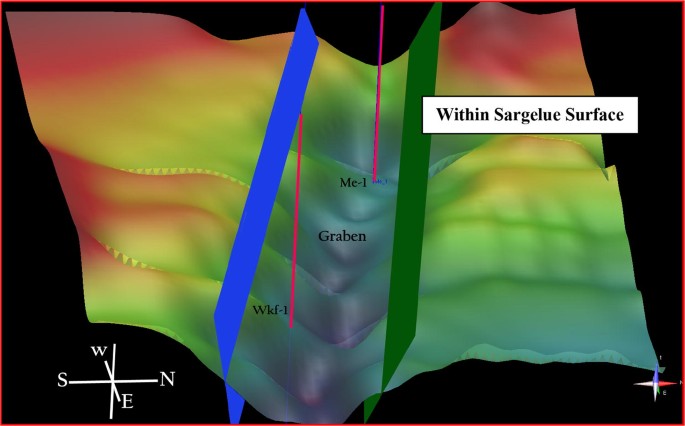
Time model of the graben effect on the Jurassic succession in the Merjan field
- (2)
Reconstruct the history of the deposition using the stratigraphy laws such as uniformitarianism, superposition and cross-cutting relationship.

Figures 8 and 9 are traverse seismic sections with NE–SW trend (basin ward) show fault system cause an extensional basin and structural inversion causes flower structure through upper Jurassic succession.

Traverse seismic section NE-SW trend (basin ward) shows fault system, the extensional basin and tectonic inversion causes flower structure through upper Jurassic succession

Seismic section (inline 44635) shows the extensional basin in the Merjan field, fault system and tectono-stratigraphic framework. The pre-rift of tectono-stratigraphic system in Jurassic is post-rift of that for Triassic time
Scenario B
This scenario of seismic interpretation relies on conversion of seismic section from time into depth domain using appropriate velocity model. Velocity model was constructed based on average velocity and seismic root-mean-square velocity. The resultant seismic depth section is more accurate than time section for structural interpretation (Fig. 10). The proposed structural model according to the depth section interpretation is anticlinal fault-bend fold which is developed along the soft unit of Gotnia Formation. Big changes in the thickness of formations can be seen in Fig. 11 as a results of the initial architecture of the basin which leds to progradation the Yamama units and lateral changes from the margin of the basin toward east and north east. This fold is a result of the compressional tectonic phase in the Middle Cretaceous-Tertiary time. This is because of the convergence between Arabian Plate (AP) and adjacent plates; however; subduction of AP beneath Eurasian plate event is occurred. It is important to point out that this scenario does not conflict with scenario A, but the latter was not clear in time section. Consequently, this scenario is additional interpretation on the previous model. Both models explain the causes of the formation of the mound seismic facies which was previously interpreted as carbonate buildup. It is important to point out that thrust event is older than graben structure in terms of chronological order.

Velocity model is constructed from average and root mean square velocity which is used in depth conversion

The interpretation of an anticlinal fault-bend fold imaged in seismic reflection data. The subsurface structures across the inline seismic profile pass across Me-1 well. a The seismic profile across inline 44653. b Shows an anticlinal fault-bend fold at subsurface responsible for the generation mound feature
Quantitative analysis of these features has been conducted. The aim of quantitative interpretation of structural feature is proving that the mound is due to the bending of layers, also to delineate the shape of fold by determining the angles values resultant from geometric analysis of anticlinal fault-bend fold.
Quantitative seismic interpretation of an anticlinal fault-bend fold
The geometric relationships between folds and their underlying faults can be epitomized through interpreted seismic section in (Fig. 11). The shape of the fault-bend fold will depend on the shape of the underlying fault.
In Fig. 11 fault plane reflections and reflection truncations define the position of a thrust ramp located beneath an anticline. Based on the imaged fold shape and fault ramp, the initial cutoff angle (θ) and inter limb angle (γ) can be defined as θ = 30° and γ = 78°.
Assume that the beds maintain their original thickness; Suppe (1983) presented a graph for fault-bend folds demonstrating the relationships between fold shape γ fault bend angle ϕ, and cutoff angles θ and β. The fault-bend fold relations are displayed in the graph where the fold is concave toward the fault.
Using the anticlinal fault-bend fold graph (Fig. 12), γ and θ are used to determine the change in fault dip (ϕ) and the hanging wall cutoff after the fault bend (β) as ϕ = 17° and β = 37°.

Graph showing the relationship between the cutoff angle and inter limb angle as function to calculate the change of fault dip and cutoff after pending for anticlinal fault-bend folds
Description of the sequence of geological events in chronological order
-
(1)
Deposition of Triassic succession, respectively, under extensional tectonic system contemporaneous with opening of Neo-Tethys.
-
(2)
Normal faulting of the Triassic succession led to creation graben structure (local sedimentary basin).
-
(3)
Syn-rift succession had been deposited in the extension basin.
-
(4)
Para unconformity.
-
(5)
Deposition of lower Jurassic and Middle Jurassic (Sargelu and Najmah Fm.), respectively, during extensional tectonic system. This is consistent with what is stated in geology of Iraq (Jassim and Goff 2006). The Mid-Late Jurassic Megasequence was deposited during a period of isolation of the main intra-shelf basin of Mesopotamia from the Neo-Tethys Ocean probably due to renewed rifting along the NE margin of the Arabian Plate. Deposition within the basin occurred in a restricted, relatively deep water environment during the Mid Jurassic. The basin became evaporitic during Late Kimmeridgian–Early Tithonian time. The base of the Megasequence starts with the basinal Sargelu Formation. The upper evaporitic part of the Megasequence comprises the evaporites of the Gotnia. The Megasequence comprises two second-order sequences: the Late Toarcian–Callovian and Late Jurassic sequences. The Najmah Formation represents the calcareous neritic and lagoonal facies of the Late Jurassic sequence on the stable shelf. Najmah Formation is conformably overlain by the Gotnia Formation. After deposition of the Najmah Formation, the conditions changed to be more arid climate associated with regression phase and the Najmah basin migrated basinward. This led to predominance of evaporites on the previous Najmah basin to form the anhydrite Gotnia Formation. The Gotnia Formation is deposited in isolated basin during of the regression phase in Late Jurassic. So, the thickness of formation is variable during the deposition as response to sea level changes during the regression. So, the thickness changes are driven by a stratigraphy agent more than tectonic factor.
-
(6)
The Gotnia Formation is deposited in isolated basin during of the regression phase in late Jurassic. So, the thickness of formation is variable during the deposition as response to sea level changes during the regression, and therefore, the thickness changes are driven by a stratigraphy agent more than tectonic factor, evaporite–carbonate lagoons and sabkha (Gotnia Formation).
-
(7)
Angular Unconformity (regression due to sub-basin creation and isolation of Gotnia basin).
-
(8)
Deposition of Sulaiy Formation as transgressive phase or HST. This is consistent with what is stated by Douban and Al-Medhadi (1999) in Jassim and Goff (2006) as that: “The Late Tithonian–Early Turonian Megasequence was deposited in a large intra-shelf basin contemporaneous with a new phase of ocean floor spreading in the Southern Neo-Tethys. The Mesopotamian zone witnessed repeated open marine incursions leading to deposition of alternating shallow water carbonates and outer shelf marls. Sedimentation began with deposition of the transgressive Sulaiy and Yamama Formations and ended with deposition of the Ratawi Formation during a high stand”.
-
(9)
Deposition of Ratawi Formation during a high stand and Zubair Formation during low stand followed by deposition of the Shuaiba Formation during a high stand.
-
(10)
Tectonic subsidence across graben system fault is continuing in the area.
-
(11)
Reactivation of fault by inversion tectonic (the second movement). This process led to folding Najmah and Gotnia Formations. In Middle Cretaceous, the AP entered a transition stage from extension into compression tectonic system. That is because of the convergence between AP and adjacent plates; however, subduction of AP beneath Eurasian plate event is occurred. Beydoun et al. (1992) described this convergence as initial collision.
Revolutionary scheme (Fig. 13) reveals the tectono stratigraphic stages of Jurassic succession. In conclusion, the tectono stratigraphic framework can be summarized as follows:

Revolutionary scheme illustrates the tectono-stratigraphic stages of Jurassic succession in the Merjan field
Normal faulting in Triassic succession as response to tectonic extension phase.
Deposition of lower and Middle Jurassic (Sargelu and Najmah Fm.) succession as post-rift sequence.
Return the tectonic extension phase and rifting of Middle Jurassic succession.
Deposition of Gotnia evaporite as syn-rift sequence.
Deposition of Lower Cretaceous succession (Sulaiy to Shuaiba Fm.) as post-rift sequence.
Tectonic inversion due to inversion the stress from extension to compression and reactivation of both Triassic and Jurassic fault system.
Folding the post-rift sequences.
Sargelu and Najmah Formations are pre-rift phase sequence.
Gotnia Formation is syn-rift phase sequence.
Sulaiy, Yamama, Ratawi, Zubair and Shuaiba Formations are post-rift phase sequence.
The Jurassic platform has been faulted because of extensional tectonic phase; thus, the grabens and half grabens are formed. Extension tectonic setting during this time led to the formation of isolated basins from open sea (euxinic environment) with rich-organic mud limestone and evaporates deposited (Murris 1980). These sub-basins are good place for sediment accumulation in reduction environment (rich in organic matter). Consequently, these basins are good source rocks and the margins of these sub-basins are good reservoirs.
Conclusions
Study of 3D seismic data in this paper depicts that the mound seismic facies is due to fault system effect on Jurassic succession as shown in two scenarios of interpretation. Fault system is consistent with Abu-Jir fault zone. These faults are developed by the extension of northeast passive margin of Arabian Plate during Mesozoic Era. Northeastward counterclockwise movement of the Arabian Plate due to the opening of Red Sea and Gulf of Aden and the collision between the Arabian and Turkish or Anatolian plates generate southward stresses.
Compression phase which occurred later in Late Cretaceous-Tertiary led to the tectonic inversion event which has been interpreted in the scenario B.
It is worth mentioning that the two presented scenarios do not conflict with each other. Both models explain the causes of the formation of the mound seismic facies which was previously interpreted as carbonate buildup.
Depth conversion is helped to make quantitative seismic analysis of feature. The proposed structural model according to the depth section interpretation is anticlinal fault-bend fold.
The new analysis of the seismic data reveals that the Jurassic succession is a faulted system and as a result of this faulting, the grabens and half grabens are formed. These sub-basins are good place for sediment accumulation in reduction environment which is rich in organic matter. Consequently, for more future works in the area, these basins may form good source rocks and margins of these sub-basins are good reservoirs.
References
Al-Ameri TK, Al-Marsoumi SW, Al-Musawi FA (2014) Crude oil characterization, molecular affinity, and migration pathways of Halfaya oil field in Mesan Governorate, South Iraq. Arab J Geosci. https://doi.org/10.1007/s12517-014-1733-z
Alhadithi AA, Salih EAM (2017) Behavior of Abu-Jir fault zone in Al-Thirthar valley and near Habbaniya Lake Areas—comparative study using seismic reflection sections. J Univ Anbar Pure Sci 11(1):47–55
Anju P, Dhananjai KP (2015) Mechanism of crustal extension in the Laxmi Basin, Arabian Sea. Geod Geodyn 6(6):409–422
Benn DI, Owen LA, Finkel RC, Clemmens S (2006) Pleistocene lake outburst floods and fan formation along the eastern Sierra Nevada, California: implications for the interpretation of intermontane lacustrine records. Quat Sci Rev 25:2729–2748
Benvenuti M (2003) Facies analysis and tectonic significance of lacustrine fan-deltaic successions in the Pliocene Pleistocene Mugello Basin, Central Italy. Sediment Geol 157(3–4):197–234
Beydoun ZR, Hughes Clark MW, stoneley R (1992) Petroleum in the Mesopotamian Basin: A late Tertiary foreland basin overprinted onto the outer edge of a vast hydrocarbon – rich Paleozoic – Mesozoic passive margin shelf. In: Macqueen RW, Leckie DA (eds) Foreland Basins and fold belts, vol 55. AAPG Memoir, pp 309–339
De Batist M (2011) Frontal emplacement and mobility of sub lacustrine landsides: results from morphometric and seismo stratigraphic analysis. Mar Geol 285(1–4):29–45
Douban AF, Al-Medhadi F (1999) Sequence chronostratigraphy and petroleum system of the Cretaceous megasequences, Kuwait. In: American association of petroleum geologists international conference, Birmingham, UK, 1999
Fadhil MS, Al-Rahim AM (2019) Using chaos and ant track attributes to recognize the faulting systems and subtle faults of a jurassic–cretaceous sedimentary packages in Merjan_West Kifl Oil Fields–Central Iraq. Iraqi J Sci 60(6):1350–1361. https://doi.org/10.24996/ijs.2019.60.6.18
Ferentions G, Papatheodorou G, Lyberis E (2002) Tectonosedimentary processes along an active marine/lacustrine half-graben margin: alkyonides Gulf, E. Gulf, E. Gulf of Corinth, Greece. Basin Res 14(1):25–41
Fouad SFA (2007) Geology of the Iraqi Western Desert. Tectonic and structural evolution. Iraqi Bull Geol Min. Special issue, pp 29–50
Frydl PM, Larson PA (1984) Analysis of potential reef depositional environment and lithofacies of the upper Jurassic sediments in Merjan #1 well, Iraq. Mobil Exploration & Production Services Inc. ESC Request No. CD50074
GEOSURV-State Establishment of Geological Survey and Mining (1996) Tectonic Map of Iraq, printed and published by the GEOSURV, Baghdad, Iraq (Arabic ref)
Jassim SZ, Goff JC (2006) Geology of Iraq. Dolin, Prague. ISBN: 80-7028-287-8
Khorshid SZ, Alki HD, Zaid AM (2016a) Subsurface investigation of Merjan oil field depending on 3D seismic reflection Central Iraq. Iraqi J Sci 57(4A):2457–2469
Khorshid SZ, AL-Sharaa GH, Ali LH (2016b) Seismic stratigraphy study of the east Razzaza within late Jurassic–early Cretaceous era (Central Iraq). Iraqi J Sci 57(4B):2692–2704
Murris RJ (1980) Middle east: stratigraphic evolution and oil habitat. AAPG Bull 64:597–618
O.E.C. (2014) Iraqi Oil Exploration Company - Geological and geophysical study of 3D seismic survey of Merjan field, p 293 (in Arabic)
Posamentier HW (2001) Seismic geomorphology and depositional systems of deep-water environments: observations from offshore Nigeria, Gulf of Mexico, and Indonesia [Abstract]. In: AAPG AnnuConvProgr, vol 10, p 160
Posamentier HW (2004) Seismic geomorphology: imaging elements of depositional systems from shelf to deep basin using 3-D seismic data: implications for exploration and development. Geol Soc Lond Mem 29:11–24
Posamentier HW, Davies RJ, Cartwright JA, Wood L (2007) Seismic geomorphology—an overview. Geol Soc Lond Spec Publ 277:1–14
Sharland PR, Archer R, Casey DM, Hall SH, Heward AP, Horbury AD, Simmons MD (2001) Arabian plate sequence stratigraphy. GeoArabia Special Publication 2, Gulf Petrolink, Bahrain, 371p
Suppe J (1983) Geometry and kinematics of fault-bend folding. Am J Sci 283:684–721
Tim C, Luo P, Zhang XY, Zhang XJ, Song JM, Zhou G et al (2010) Structural controls on facies distribution in a small halfgarben basin: luanping basin, northeast China. Basin Res 22(1):33–44
Wood LJ (2007) Quantitative seismic geomorphology of pliocene and miocene fluvial systems in the northern Gulf of Mexico. USA J Sedim Res 77:713–730
Zeng HL, Hentz TF (2004) High-frequency sequence stratigraphy from seismic sedimentology: applied to Miocene, Vermilion Block 50, Tiger Shoal area, offshore Louisiana. Am Assoc Pet Geol Bull 88(2):153–174
Zhu H, Li S, Shu Y, Yang XH, Mei LF (2016) Applying seismic geomorphology to delineate switched sequence stratigraphic architecture in lacustrine rift basins: an example from the Pearl River Mouth Basin, northern South China Sea. Mar Pet Geol. https://doi.org/10.1016/j.marpetgeo.2015.12.013
Ziegler M (2001) Late Permian to Holocene paleofacies evolution of the Arabian Plate and its hydrocarbon occurrences. GeoArabia 3:445–504
Author information
Authors and Affiliations
Corresponding author
Additional information
Publisher's Note
Springer Nature remains neutral with regard to jurisdictional claims in published maps and institutional affiliations.
Rights and permissions
Open Access This article is distributed under the terms of the Creative Commons Attribution 4.0 International License (http://creativecommons.org/licenses/by/4.0/), which permits unrestricted use, distribution, and reproduction in any medium, provided you give appropriate credit to the original author(s) and the source, provide a link to the Creative Commons license, and indicate if changes were made.
About this article

Cite this article
Fadhel, M.S., Al-Rahim, A.M. A new tectono sedimentary framework of the Jurassic succession in the Merjan oil field, Central Iraq. J Petrol Explor Prod Technol 9, 2591–2603 (2019). https://doi.org/10.1007/s13202-019-00750-1
Received:
Accepted:
Published:
Issue Date:
DOI: https://doi.org/10.1007/s13202-019-00750-1