
Abstract
Geoconservation consists of the selection and conservation of geodiversity elements that have significant heritage value. The management of geological sites is based on specific procedures to ensure public use and minimize adverse impacts. The evaluation of the carrying capacity of geological sites is a management tool that helps to define the acceptable limits of visitation, without causing significant impacts on the integrity of these sites. This work presents a review of the carrying capacity concept and the most common methods used to assess the carrying capacity in tourist destinations. Based on this review and analysis of the advantages and disadvantages of existing methods, this work presents a method that defines a set of actions for management and calculation of the number of visitors recommended for geological sites, based on specific geoindicators for each type of site.
Introduction
The increase of visitors in national parks and other designated areas in the USA in the middle of the twentieth century obliged park managers to improve the management strategies of these protected areas (Soller and Borghetti 2013). Therefore, the concept of carrying capacity (CC), initially proposed under the scope of biological sciences (ecology) and applied in the context of wildlife, agriculture, and livestock, became an important tool for the management of recreation and leisure areas. Initially, CC was applied primarily on the identification and quantification of human activities impacts in protected areas (Takahashi 1998; Shaofeng 2004; Pires 2005; Manning 2007; Delgado 2007; Coutinho 2010; Soller and Borghetti 2013; Zelenka and Kacetl 2014; Sharma 2016; Kennell 2016). Later on and influenced by the sustainability paradigm, the CC concept gained global relevance and started to also address cultural and economic issues of the population living in tourist areas (Pires 2005; Kostopoulou e Kyritsis 2006; Coutinho 2010).
Several methodological studies were developed in the beginning of the 1990s, aiming the evaluation of the tourism carrying capacity (TCC) in protected areas (Cifuentes 1992; Cifuentes-Arias et al. 1999; Coccossis and Mexa 2004a, b; Boullón, 2006). These and other methodological models propose a quantitative TCC assessment by setting up the maximum number of visits that a place can withstand and a qualitative assessment by identifying which are the acceptable conditions for a certain site. In recent years, different methodological approaches that include distinct TCC types have been applied as tools for the management of protected areas in several parts of the world, like Costa Rica (PROARCA 2006), Rio Grande do Sul (Brazil) (Soller and Borghetti 2013), Java Island (Aryasa et al. 2017), and Paraná (Brazil) (Pontes and de Paula 2017).
However, the use of TCC as a tool applied to the management of geological sites is still very scarce. The more consolidated TCC studies are related to management of caves, e.g., Boggiani et al. (2007), Lobo (2009b, 2011, 2015), and Lobo et al. (2013). Other TCC studies in geological sites were done by Coutinho (2010) at Penha Garcia geosite (Naturtejo UNESCO Global Geopark, Portugal), by Lima (2012) and Lima et al. (2017) at Ponta da Ferraria and Pico das Camarinhas geosite (Azores UNESCO Global Geopark, Portugal), and by Guo and Chung (2017) at geoparks in Hong Kong.
Sharples (2002) defines geoconservation as the conservation of the diversity of significant geological (bedrock), geomorphological (landform), and soil features and processes whilst keeping the natural evolution of these processes as a function of their intrinsic and heritage values. This author adds that the objectives of geoconservation are to preserve and assure the maintenance of geodiversity, to protect and safeguard the integrity of places whose geodiversity is relevant, to minimize the adverse impacts on these sites where geodiversity exhibits a relevance above average, to interpret and explain geodiversity to visitors of protected areas, and to contribute to the safeguard of biodiversity and ecological processes.
Brilha (2016) highlights the need to establish geoconservation strategies in order to ensure the preservation and sustainable management of geoheritage by means of specific procedures that include inventory, quantitative assessment, conservation, interpretation and promotion, and monitoring of sites. According to Gordon et al. (2018), geoconservation must address a set of fundamental principles for the implementation of a holistic approach in practice and the integration of geoconservation in the preservation of nature and in the planning and management of geological sites. Furthermore, measures must be taken for the control of visitors in sensitive sites and for the promotion of education and interpretation of the whole natural heritage.
This work revises the CC concept with emphasis on the CC assessment applied to tourist destinations. The literature review is focused on the CC understanding and its conceptual and methodological evolution throughout time. It is shown how the CC concept as a tool for planning and maintenance can be combined with geoconservation and applied to the sustainable management of geological sites. The main methodological applications in geological sites are analyzed, with a special focus on protected areas, and the advantages/disadvantages of the different methods are discussed.
The Concept of Carrying Capacity
The concept of carrying capacity or support capacity appeared in the end of the nineteenth century applied to biological sciences, ecology, and human ecology. The “idea” or “need” to establish a carrying capacity was registered for the first time between 1880 and 1885 in the Random House Webster's Collegiate Dictionary and in 1906 in the annual catalog of the Department of Agriculture of the United States, primarily related with the management of pastures (Price 1999; Shaofeng 2004).
In the beginning of the twentieth century, Hadwen and Palmer (1920) introduced for the first time the ecological CC concept by studying the deer population in Alaska (Shaofeng 2004). Many authors (Takahashi 1998; Shaofeng 2004; Manning 2007; Delgado 2007; Coutinho 2010; Zelenka and Kacetl 2014; Sharma 2016) emphasize that the first studies tackled, mostly, the management of wild life, livestock, and agriculture. The first methodological (practical) applications of the concept emerged in the USA and mostly made reference to the number of animals of a certain species that could be kept at the same time in a given habitat (Dasmann 1945). The studies applied to livestock aimed at determining the number of cattle that can be kept in a certain area without causing irreversible damage to pastures (Soller and Borghetti 2013; Sharma 2016).
Still, during the early decades of the twentieth century, the CC concept started being applied to define environmental limits that result from human activities. Shaofeng (2004) distinguished two main areas of application: basic ecology and human ecology.
The CC concept in basic ecology refers to the management of habitats and specific ecosystems (like wildlife and pastures) and the management of tourism. It has as its primary objective the identification of the saturation limit of a certain species in a certain area. Once this limit is reached, the population of that species is at the maximum level to allow its sustainability (Pazienza 2004).
When applied to human ecology, CC refers to the impacts and ecological limits that result from the human population growth and consumption increase (Shaofeng 2004).
Tourism Carrying Capacity Applied to Protected Areas
The TCC concept became a very important tool for the management of recreational and leisure spaces, namely on the identification and calculation of human activity impacts in protected areas (Takahashi 1998; Shaofeng 2004; Pires 2005; Manning 2007; Delgado 2007; Coutinho 2010; Soller and Borghetti 2013; Zelenka and Kacetl 2014; Sharma 2016; Kennell 2016).
The first attempt to apply the CC concept to protected areas was made in the 1930s; in a US National Park Service (NPS) report, it was questioned: “what is the number of people that can walk along a natural area without destroying its essential qualities?” (Sumner, 1936 cited by Manning 2007). However, it was only in the decade of 1950, with the increase of visitors in national parks and other protected areas in the USA, that CC became part of visitors’ management (Soller and Borghetti 2013). In the decade of 1960, Wagar (1964) proposed the broadening of the CC concept as “the level of use that an area can sustain without affecting its quality.” This work emphasized that, in addition to the management of protected areas, the social aspects and the experience of visitors should also be incorporated into the CC concept (Stankey and Cole 1998; Takahashi 1998; Takahashi and Cegana 2005; Pires 2005; Manning 2007; Coutinho 2010; Soller and Borghetti 2013). According to these authors, the management of visitors in protected areas must involve a set of management actions and not only the limitation of the number of visitors.
In the beginning of the decade of 1980, the United World Tourism Organization (UNWTO) defined TCC as “the maximum number of people that may visit a tourist destination at the same time, without causing the destruction of the physical, economic and sociocultural environment and an unacceptable decrease in the quality of visitors satisfaction” (McIntyre 1993).
In 1984, the management plan of the Galápagos National Park (Ecuador) included a method to calculate the TCC of trails and beaches, which was later revised and applied to protected areas of Costa Rica (Cifuentes 1984). According to Cifuentes (1992) and Cifuentes-Arias et al. (1999), TCC is “a type of environmental carrying capacity that refers to the biophysics and social capacities around the tourist activity and its development” and represents the maximum limit of human activity in a certain area.
The U.S. National Park Service (1993) revises the TCC concept and defines it as the level of use that may be conciliated whilst sustaining the desired resources and the recreation conditions that integrate the objectives of the unit and the management goals. Takashi (1998) stresses that TCC may, or may not, define a maximum number of visitors, depending on the recreation conditions. If the resources are adequate and the recreational conditions are kept, the number of visitors will have secondary importance.
In 1992, the United Nations Conference on Environment and Development took place in Rio de Janeiro, Brazil (Rio-92). Rio-92 was an important milestone and raised global awareness on sustainable use and development. Under the influence of that new paradigm, the TCC concept gained global relevance and boosted the concern with sociocultural and economic issues related to local populations at tourist areas (Pires 2005; Kostopoulou and Kyritsis 2006; Coutinho 2010).
Types of Tourism Carrying Capacity
According to Coccossis and Mexa (2004a, b), the first split of the TCC concept into three categories was suggested by Pearce (1989): environmental and ecologic, physical, and perceptive or psychological, reflecting the different dimension on which the concept was applied. However, based on Boullón (2006), Pires (2005), Coccossis and Mexa (2004b), Kostopoulou and Kyritsis (2006), Nghi et al. (2007), and Kennell (2016), the more recurring categories for the application of the TCC concept in tourism management are: ecological and physical, material, perceptive/psychological/social, and political/economical.
The ecological and physical TCC aims at identifying and quantifying the impacts caused by recreation and tourism on ecosystems (Pires 2005). It consists on the determination of the limits of acceptable ecological degradation based on the definition of a maximum number of visitors. While the ecological TCC refers to the impacts caused in the natural environment, the physical TCC refers to elements of the built environment, mainly to infrastructure systems (like supply services, transports, health services, electricity). According to Boullón (2006), the material TCC refers to the geological, geographical, and biological characteristics associated with the safety conditions for visitation in tourist sites. The perceptive/psychological/social TCC is related to the experiences of the visitor in a tourist site and to eventual impacts on local communities. According to Getz (1983, cited by Kennel 2016) while the perceptive TCC is a measure of the limit perceived by the tourist, the social TCC refers to the maximum use of a tourist resource, without causing unacceptable levels of negative feelings by the tourist. Finally, the political/economical TCC refers to the economic impacts generated by the tourist activity (Kostopoulou and Kyritsis 2006). According to Getz (1983 cited by Kennell 2016), the political/economical TCC of a tourist site is the maximum use of the resource before leading to an unacceptable level of economic dependence on tourism and without causing political instability, for example, conflicts over land rights or control of tourism revenues.
Methods for the Tourism Carrying Capacity Assessment and Their Application in Protected Areas and Geological Sites
The CC assessment applied to the management of tourist sites can be based on quantitative and qualitative methods (Pires 2005). While the former calculates numerical standards for TCC quantification, the latter proposes management models for protected areas. There is also a set of quantitative and/or qualitative methods that are specific for the TCC calculation in speleological sites (or speleological carrying capacity), already compiled by Santos (2019). For each one of these three groups (quantitative, qualitative, and speleological TCC), it is presented a brief analysis and examples of application with emphasis on protected areas and geological sites, as well as advantages and disadvantages pointed out by several authors (Pires 2005; Delgado 2007; Manning 2007; Boggiani et al. 2007; Lobo 2009; Coutinho 2010; Lobo et al. 2010, 2013; Lobo 2015; 2017; Santos 2019) (Tables 1, 2 and 3).
Quantitative Methods
A comparison between some of the quantitative methods already published is presented in Table 1.
The Cifuentes method was applied for the first time in 1984, as part of the revision of the management plan of Galapagos National Park (Ecuador). It gained international recognition and was thereafter applied to calculate TCC in several protected areas in different countries. A few years later, Boullón (2006) introduced the concept of “rotativity coefficient” and reintroduced the concept of “personal distance” or “ecological bubble” for the TCC assessment in natural areas. The model of density by zone type in protected areas is based on environmental zoning, which is a tool that establishes the territorial planning and rules for soil occupation and use of natural resources (IBAMA 2001). The guidelines for management different zones are formulated after identifying the vulnerabilities and possibilities of each zone, based on the environmental particularities of the region, and on its interaction with the current social, cultural, economic, and political processes (IBAMA 2001; FADURPE 2010). While areas with little modifications due to anthropic actions can receive about 20 visitors per km2, areas with significant modifications can have about 500 visitors per km2 (Pires 2005).
Qualitative Methods
In parallel to the development of quantitative methods for TCC assessment, since the decade of 1970, qualitative methods are helping to define models for the management of public use in protected areas. These models consider that TCC is the “level of recreational use that may be accommodated in a park or related areas without the overstepping the limits established by variables of relevant indicators” (Manning 2007). The models that are most known and used include the Recreational Opportunity Spectrum (ROS) (Clark and Stankey 1979); Limits of Acceptable Change (LAC) (Stankey et al. 1985); Visitor Impact Management (VIM) (Graefe et al. 1990); Visitor Activity Management Process (VAMP) (Environment Canada and Service Park 1991); Visitor Experience and Resource Protection (VERP) (National Park Service 1993, 1997; Manning 2001); Carrying Capacity Assessment Process (C-Cap) (Shelby and Herberlein 1986); and Tourism Optimization Management Model (TOMM 2000). The main advantages and disadvantages of three of these models that are more widely used in the tourism management of protected areas (LAC, VERP, and TOMM) and the method proposed by Coccossis and Mexa (2004a, b) are presented in Table 2.
The concept of “Limit Acceptable Change” (LAC) was proposed by Frissell and Duncan (1965) assuming that recreational activities in natural environments cause negative impacts on the environment. These impacts must be identified, and the limit of acceptable change for a certain natural environment must be defined. Once this limit is reached, measures must be undertaken to avoid the deterioration of the environment in order to avoid “adverse changes.” LAC is a technical model of planning that enables a systematic definition of acceptable ecological and social changes resulting from recreational and tourist activities, which facilitates the decision by managers (Stankey and Cole 1998; Takahashi 1998; Takahashi and Cegana 2005; Pires 2005).
The VERP method was developed by NPS in 1992 in order to improve the management of visitors and TCC assessment in public areas (Pires 2005; Coutinho 2010). This model emphasizes both the quality of the natural resources and the visitor experience. Belnap et al. (1997) and Manning (2004, 2007) state that the structure and development of this model were an adaptation of the LAC method. Although some of the aspects, like terminology and sequence of stages, may vary, in general, the two methods display a common rational:
-
1.
Definition of the area conditions to be maintained in terms of management objectives/desired conditions and associated impact indicators and standards, considering resources, visitor experience, and management of parks and outdoor recreation;
-
2.
Monitoring of indicators to determine if existing park conditions meet the standards that have been specified;
-
3.
Management actions to assure that the standards are maintained.
The Tourism Optimization Management Model (TOMM) was developed in 1996 as a new model for the sustainable management of tourism in the Kangaroo Island, Australia (TOMM, 2000, 2016). This model, like LAC and VERP, is composed by stages that involve the definition of the required conditions, the identification of indicators and standards, the monitoring of indicators, and the application of management actions. However, the main focus is the management of tourism considering the sustainable economic benefits. Hence, the identification of maximum limits of use and the carrying capacity are secondary to the model (Pires 2005; Lessa 2006; Coutinho 2010).
Finally, the method proposed by Coccossis and Mexa (2004b) for TCC assessment involves descriptive and evaluation elements. The former includes physical, ecological, social, political, and economic aspects that will help to identify the restrictions (limiting factors with difficult management), obstructions (limiting factors that may be manipulated by the managers), and impacts (elements affected by the intensity of use). Evaluation elements describe how an area must be managed and what is the limit of acceptable change. Coccossis and Mexa (2004b) also present a set of indicators for the sustainable development of tourism (e.g., quality of air, production and management of waste, use of soil, consumption and quality of water, social behavior, profits, and investment in tourism) and TCC indicators (e.g., number of days that the pollution standards are exceeded, daily consumption of water and electricity in activities related to tourism, average production of waste). This type of approach has been widely used in protected areas with high ecological value.
Methods for TCC Assessment in Speleological Sites
The carrying capacity of speleological sites is defined as the “possibility to limit in time and/or space the use of a cave so that environmental damage does not occur, its resilience capacity” (Lobo 2008). Lobo et al. (2009) discuss the necessity of multidisciplinary studies involving the biodiversity and geodiversity assessment to define TCC in caves. In what concerns the assessment of the physical environment, these authors highlight the need of a climate monitoring (like temperature and relative air humidity) inside the cave. Based on the monitoring of these variables, some authors (e.g., Hoyos et al. 1998; Calaforra et al. 2003; Sgarbi 2003; Scaleante 2003; Fernández-Cortés et al. 2006; Boggiani et al. 2007) have established TCC as the maximum number of visitors allowed daily inside the cave. While this procedure may be sufficient to plan the speleological use in the early stages, more detailed studies might be necessary in more complicated situations (Lobo et al. 2009).
The main advantages and disadvantages of the three methods proposed by Lobo and co-authors are presented in Table 3.
Proposal for the Tourism Carrying Capacity Assessment Applied to Geological Sites
The management of geological sites should be planned in order to achieve the conservation objectives and, at the same time, ensure the quality of visitation (Lima 2012). The TCC assessment of geological sites is justified because it is a management tool that helps to define the acceptable limits of visitation, without causing significant impacts on the site integrity (Brilha 2018b). In addition, monitoring actions that are necessary to calculate TCC can provide information about the evolution of the conservation status of the site throughout time.
Based on the models and their applications presented in the “Methods for the Tourism Carrying Capacity Assessment and Their Application in Protected Areas and Geological Sites” section and on the aims of a geoconservation strategy (Brilha 2016), a proposal for the TCC assessment as a tool for the proper management of geological sites is presented below. As it is intended to contribute to the TCC assessment under the scope of geoconservation (considering the potential use and degradation risk of each geological site), it will be given more emphasis to TCC components that assess the natural environment, specifically the physical-ecological or material carrying capacity, in order to highlight the geological characteristics in these sites. The following proposal comprises three steps (Table 4): (A) system analysis, (B) management priority, and (C) calculation of carrying capacity.
Part A—System Analysis
The system analysis is based on the method proposed by Coccossis and Mexa (2004b) and involves the following stages: (i) analysis of the physical characteristics, biodiversity, and geodiversity; (ii) analysis of the tourism activity; and (iii) analysis of management policies. The geodiversity analysis includes the inventory of geological sites, which corresponds to the first stage of a geoconservation strategy (Brilha 2016). The analysis of the tourism activity in the region includes the characterization of the existing tourist offer and demand and the definition of the visitors’ profile (Coccossis e Mexa 2004b). The knowledge about the existent management policies may help to define the management objectives of each geological site, i.e., the activities and the type of tourism that may be practiced, and to select which geological sites need to be protected, in accordance to international, national, regional, and local regulations (Brilha 2016, 2018a).
Part B—Management Priority
The quantitative assessment of the scientific value, tourist and educative potential uses, and risk of degradation of geological sites contributes to rank these sites and to establish management priorities (Brilha 2016). Sites with higher tourist and educational potentials and a higher risk of degradation should be the first ones to have a TCC evaluation. It is important to highlight that if the geological sites that are included in the same study area are located in different administrative regions, this may imply that they are under different public use policies. In this case, the establishment of management priorities should be done before the system analysis.
Part C—Calculation of the Tourism Carrying Capacity
This calculation starts with an environmental zoning aiming to define the occupation and norms of use of a certain site and its management needs. The zoning of the geological site, i.e., the subdivision into zones in order to facilitate the definition of the type of use, according to the different management categories, should group the geological elements of main interest (aspects) and the secondary geological elements (sub-aspects), in accordance to the proposal of Wimbledon et al. (2004) for the preparation of management plans for geological sites.
The processes and pressures that affect or may affect the state of conservation of the site must be identified, considering the aspects and sub-aspects that were characterized in each zone or geological site. According to Cifuentes (1992) and Cifuentes-Arias et al. (1999), this stage consists of identifying factors, i.e., characteristics that influence each site by means of impact indicators. Factors can affect directly or indirectly a site, making it more vulnerable and diminishing or increasing the public interest in accordance to possible changes of the main aspects or sub-aspects. Factors may have natural (e.g., erosion, vegetation growth) or anthropic (e.g., trampling, resource exploration, infrastructures) causes. Authors like Stankey et al. (1985), Merigliano (1987, 1990), and Manning (2007) argue that the selection of good impact indicators must be specific, objective, trustable, related to public use, sensitive, manageable, efficient and effective to measure, interactive, and meaningful. García-Cortés et al. (2012) and Diez-Herrero et al. (2018) refer to impact indicators as geoindicators, according to the definition of Berger and Iams (1996): measures (magnitudes, frequencies, rates, and trends) of phenomena and geological processes that occur at or close to the surface and are subjected to significant changes for understanding environmental changes in a period up to one hundred years. Hirai and Augusto Filho (2008) describe several geoindicators that are usually mentioned in the literature. Visitation impact indicators should also be identified; relevant examples are explained in Lobo and Simões (2010) and ICMBio (2011).
After the identification of geoindicators and visitation impact indicators, procedures for the periodic monitoring and analysis of data must be established for each zone or for the whole geological site. For each indicator (geoindicator/visitation impact indicator), the limits of acceptable alteration (desirable conservation status) (Stankey et al. 1985) (LACV) or the maximum accepted measurement conditions (National Park Service 1993, 1997; TOMM 2000) must be established, i.e., the conditions that must be maintained for each indicator from the establishment of standards. In LAC, VERP, and TOMM models, the definition of the desired level for each indicator should be related to the capacity of the environment (e.g., pollution levels). The definition of standards for the geoindicators and indicators of impact of visitation should be based on a reference value, obtained during the initial phase of monitoring at the geological site. After a certain period of monitoring, the established standards may be confronted with the indicators, helping in the TCC assessment and on the management actions. It is recommended that the monitoring of each indicator should cover 12 months so that the different seasons of the year are considered.
The geological site TCC must be defined after the evaluation of the data obtained during the indicators’ monitoring considering:
-
1.
A set of management actions directed towards keeping the limits of acceptable change of the set of indicators, or
-
2.
Limitation of the number visitors in a zone or geological site.
Monitoring data will supply information about the impact caused at a geological site. In general, an impact is not associated with only on indicator, but rather to a set of indicators (ICMBio 2011).
Thus, when there are signs that the acceptable limit for a key indicator or set of indicators has been exceeded, one must consider the changes in the established standards and assess the impacts and their possible causes. Knowing these impacts and their causes, whether natural or related to public use, specific management actions must be implemented in order to re-establish the standards, that is, to maintain the TCC of the zone or site in question.
Management strategies are a set of actions or interventions to control, minimize, and/or eliminate the impacts caused to the environment (Lobo and Simões 2010). These actions must be planned in order to minimize the medium- and short-term impacts and should need a low budget (ICMBio 2011).
Once the limits of acceptable change are exceeded and case the management strategies are not sufficient to control the impacts on a site, then the number of visitors should be limited, according to the following formula:
where
\(LNU\) = Maximum number of visitors (carrying capacity).
\(LACV\) = Maximum acceptable change of an indicator.
\(AI\) = Average impact caused by one visitor.
The value LACV is obtained from the following expression:
where:
\(LAC\) = Maximum acceptable change for an indicator, defined by the pre-established standards.
\(NEC\) = Natural expectable change due to natural processes and without any anthropic influence.
The AI value may be calculated from the monitoring data (when available):
where:
\(IC\) = observed indicator change (monitoring data).
\(NIC\) = natural indicator changes (indicator changes caused by natural processes and without anthropic influence).
\(NV\) = number of visitors during the monitoring period.
There may be cases in which the monitoring data is not detailed enough to distinguish which part of the change is caused by natural processes and which one is caused by anthropic factors. In these cases, the value NIC must be estimated according to the standards established in the literature for that region. When monitoring data are not sufficient for a trustful estimation of the average impact caused by one visitor (AI), this value can be assumed based on values presented in the literature and in which the conditions of the geological site are as similar as possible to the site under study.
After the calculation of the maximum number of users (LNU) for each indicator, the carrying capacity of the zone or geological site is given by the minimum value obtained within all the indicators and should not exceed the real carrying capacity that can be calculated according to Cifuentes (1992), in which only the correction factors associated with restrictions that limit the physical access to the site are considered.
After the TCC calculation of a geological site, there is a period in which the impact factors should be monitored. By the end of this period, the monitoring and management strategies can be reviewed, together with the TCC value, if necessary.
In case the management conditions are kept or improved (for example, recovery of accessibility, implementation of infrastructures, availability of new services), the TCC revision must follow what is expressed in Fig. 1. In these cases, one must verify if the impact indicators are in conformity with the established standard. If that is not verified, and if after the analysis of the causes of the impacts it is concluded that such is due to intensive public use, then the TCC value must be reduced, i.e., the number of visitors must decrease. If, on the other hand, the analysis of the causes of impacts concludes that the extrapolation of indicators is not directly related to a high public use, then TCC can be increased. Independently on the motives that led to the exceedance of standards, the TCC revision can be attained with management actions at the site. In case the monitoring data reveal that the indicators are in conformity with the established standards, then TCC can be redefined and the visitor number increased.
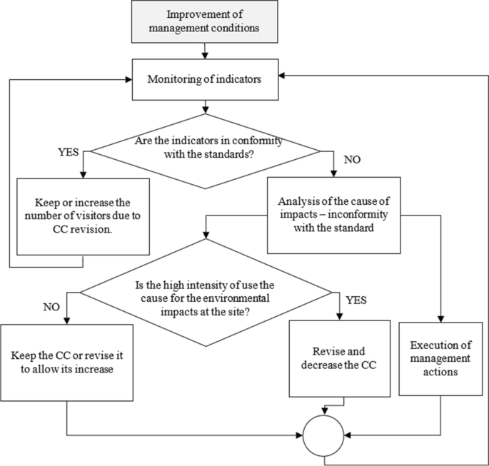
Decision flux for the analysis of tourism carrying capacity in case of improvement of the management conditions at the geological site (adapted from ICMBio 2011)
When the management conditions of the geological site get worse, the TCC revision must be based on what is shown in Fig. 2. In these cases, one must try to understand if the factors that limit the site visitation (visitation impact indicators) considered in the TCC calculation have changed. In case they did change, then TCC must be revised and reduced. If there are no changes in the factors that limit visitation, it must be verified if the management conditions have deteriorate the capacity for public use. In this case, new indicators may be included in the review of the TCC calculation. After assessing the management conditions in the site, the review of the procedure for TCC assessing is concluded following the same procedures adopted in cases where management conditions have been maintained or improved (i.e., from the verification whether the impact indicators are in accordance with the established standard).
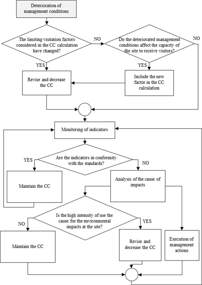
Decision flux for the analysis of the tourism carrying capacity in case the management conditions at the geological site deteriorate (adapted from ICMBio 2011)
Finally, in both situations of improvement or deterioration of management conditions, it should be noted that the TCC review at one geological site is cyclic and is directly related to the data collected from the impact indicator monitoring. However, for the TCC calculation, it is necessary to establish strategies for the control of visitors (tickets, entrance quotas, etc.) in the period of monitoring and analyze the direct relation between the levels of use and the environmental quality at the geological site (ICMBio 2011).
Final Considerations
The review of the TCC concept and of the different methods for its assessment carried out in this work has shown that there is neither a universally accepted definition nor a standard application that can be used in all circumstances. Different approaches to this concept imply different ways of calculation, which is reflected in different interpretations increasing the complexity of the subject.
The inefficiency of imposing a limit on the number of visitors to control environmental impacts in protected areas opened space for the development of methods to manage visitor impacts. However, obtaining data to establish acceptable limits of change is quite time-consuming, and the management strategies to be implemented require investment, which is a disadvantage in applying the TCC concept.
The proposal developed in this work is based on the evaluation and integration of practices analyzed in the methods of TCC evaluated previously. The procedures for TCC assessment in geological sites include three distinct steps. The initial procedures (part A) focus on the identification and characterization of the main geodiversity elements, analysis of their potential use, and management policies for the study area. Part B establishes the management priorities for geological sites, and part C seeks to collaborate and extend discussions on overcoming the main disadvantages associated with the previous methods, by defining and monitoring geoindicators and other indicators of visitors’ impact.
Thus, this method can be applied to geological sites at different scales (local, regional, national) in different “area types” (e.g., protected areas, geoparks, urban sites) and diverse geological contexts (e.g., palaeontological, geomorphological, tectonic sites). However, among the main challenges of implementing this method, as verified in most of the methods evaluated in this work, is the need for a systematic monitoring of geological sites throughout at least 1 year, so that the different seasons of the year can be considered and possible factors affecting the site can be identified. Only its practical application will allow us to obtain data and answers regarding its effectiveness and possible impasses. However, the characterization of geological processes at certain sites may require years of research, and the techniques for monitoring and implementing concrete management actions may need significant funding.
We can conclude that the TCC assessment of a geological site is more than just establishing or setting a number of visitors. This assessment should also involve a series of steps that allow for knowing the site, establishing criteria for the identification and monitoring of indicators, developing management strategies, and periodic review/reassessment of these steps, becoming a cyclical process. These results should be made compatible with the assessment of other “types” or “categories” of carrying capacity (ecological, perceptive/psychological/social, and political/economic), so as to promote the sustainable use of the site. Since this is a complex method and may last several years, it requires a management team focused on geoconservation and determined to make the correct management of geological sites. Unfortunately, there are still few examples in the world where this situation occurs.
The TCC assessment method presented here was applied to geological sites of Alto Ribeira Touristic State Park (PETAR) and its surroundings in São Paulo State, Brazil. The description and analysis of this case study will be presented in another article.
Data Availability
“Not applicable” for that section.
Code Availability
“Not applicable” for that section.
References
Amador E, Cayot L, Cifuentes M, et al (1996) Determinación de la capacidad de carga turística en los sitios de visita del Parque Nacional Galápagos. Servicio Parque Nacional Galápagos, Ecuador 42p
Aryasa AM, Bambang AN, Muhammad F (2017) The study of environmental carrying capacity for sustainable tourism in Telaga Warna Telaga Pengilon Nature Park, Dieng Plateu, Central Java. In: IOP Conference Series: Earth and Environmental Science. IOP Publishing, pp 1–5
Barros MIA de (2003) Caracterização da visitação, dos visitantes e avaliação dos impactos ecológicos e recreativos do planalto do Parque Nacional do Itatiaia. Universidade de São Paulo
Berger AR, Iams WJ (1996) Geoindicators—assessing rapid environmental changes in earth systems: Rotterdam. AA Balkema
Boggiani PC, da Silva OJ, Gallati EAB et al (2007) Definição de capacidade de carga turística das cavernas do Monumento Natural Gruta do Lago Azul (Bonito, MS). Geociências (são Paulo) 26:333–348
Boullón R (2006) Planificación del espacio turístico, 4a edição. Editorial Trillas
Brilha J (2005) Património geológico e geoconservação: a conservação da natureza na sua vertente geológica. Palimage
Brilha J (2016) Inventory and quantitative assessment of geosites and geodiversity sites: a review. Geoheritage 8:119–134
Brilha J (2018a) Geoheritage: inventories and evaluation. In: Geoheritage. Elsevier, pp 69–85
Brilha J (2018b) Geoheritage and geoparks. In: Geoheritage. Elsevier, pp 323–335
Calaforra JM, Fernández-Cortés A, Sánchez-Martos F et al (2003) Environmental control for determining human impact and permanent visitor capacity in a potential show cave before tourist use. Environ Conserv 30:160–167
Camargo AL (2008) Proposta de método de determinação da capacidade de carga de visitação turística para as cavernas da região de Bulhas D’Água e Vale dos Buenos no Parque Estadual de Intervales e no Parque Estadual e Turístico do Alto Ribeira, Estado de São Paulo. Trabalho de MBA, Instituto Mauá da Tecnologia
Cerro FL (1993) Técnicas de Evaluacion dei potencial Turístico. Ministério de Industria, Comercio y Turismo-Centro de publicaciones, Madrid
Cifuentes M (1992) Determinación de capacidad de carga turística enáreas protegidas. Bib, Orton IICA/CATIE
Cifuentes M (1984) Parque Nacional Galápagos. Plan de Manejo y Desarollo. II Fase. Quito. Ec., Comisión de Alto Nivel Plan Maestro Galápagos – Grupo Técnico – 202p.
Cifuentes-Arias M, Mesquita CAB, Méndez J, et al (1999) Capacidad de carga turística de las áreas de uso público del Monumento Nacional Guayabo, Costa Rica. Turrialba, CR: WWF
Clark RN, Stankey GH (1979) The recreation opportunity spectrum: a framework for planning, management, and research. Gen Tech Rep PNW-GTR-098 Portland, OR: US Department of Agriculture, Forest Service, Pacific Northwest Research Station 32 p 98:
Coccossis H, Mexa A (2004a) Tourism carrying capacity: a theroretical overview. In: the challenge of tourism carrying capacity assessment: theory and practice. Ashgate, pp 37–53
Coccossis H, Mexa A (2004b) Tourism carriying capacity: methodological considerations. In: the challenge of tourism carrying capacity assessment: Theory and practice. Ashgate, pp 55–90
Coccossis H (2004) Sustainable tourism and carrying capacity: a new context. In: the challenge of tourism carrying capacity assessment. Routledge, pp 19–30
Costa EJ (2004) Abismo Anhumas (MS 04): Plano de Manejo Espeleológico. rev. e ampl. Bonito: Abismo Anhumas
Cole DN (1987) Assessing and monitoring backcountry trail conditions. US Department of Agriculture, Forest Service, Intermountain Forest and Range
Coutinho IMA (2010) Avaliação da capacidade de carga turistica para o geossítio de Penha Garcia. Dissertação de Mestrado, Instituto Superior de Agronomia
da Lessa B, C (2006) Proposta de um método de análise de capacidade de carga turística para o empreendimento Ilha de Porto Belo-Ilha João da Cunha-(Município de Porto Belo/SC-Brasil). Universidade do Vale do Itajaí, Dissertação de Mestrado
Dasmann RF (1945) Wildlife biology. Wiley
Delgado M (2007) Análise da metodologia criada por Miguel Cifuentes referente à capacidade de carga turística. Revista Turismo Em Análise 18:73–93
Díez-Herrero A, Vegas J, Carcavilla L, et al (2018) Techniques for the monitoring of geosites in Cabañeros National Park, Spain. In: Geoheritage. Elsevier, pp 417–430
Environment Canada, Service Park (1991) Selected readings on the visitor activity management process. Environment Canada, Ottawa, Ontario
FADURPE (2010) Zoneamento ambiental da área de proteção ambiental - APA Santa Cruz – Itapissuma. Itamaracá e Goiana/PE, CPRH - Agência Estadual de Meio Ambiente, Recife
Fernández-Cortés A, Calaforra JM, Sánchez-Martos F, Gisbert J (2006) Microclimate processes characterization of the giant geode of Pulpí (Almería, Spain): technical criteria for conservation. Int J Climatol 26:691–706
Frissell SS, Duncan DP (1965) Campsite preference and deterioration in the Quetico-Superior canoe country. J Forest 63:256–260
Frissell SS, Stankey GH (1972) Wilderness environmental quality: search for social and ecological harmony. Society of American Foresters Hot Springs, AR
García-Cortés Á, Vegas J, Carcavilla L, Díaz-Martínez E (2012) Un sistema de indicadores para la evaluación y seguimiento del estado de conservación del patrimonio geológico. Geo-Temas 13:1272–1275
Getz D (1983) Capacity to absorb tourism: concepts and implications for strategic planning. Ann Tour Res 10:239–263
Gómez MJM, Rosabal PM, Salinas Chávez E (1993) Planificación y desarrollo del ecoturismo. Estudios Turísticos 119–120:39–58
Gordon JE, Crofts R, Díaz-Martínez E, Woo KS (2018) Enhancing the role of geoconservation in protected area management and nature conservation. Geoheritage 10:191–203
Graefe AR, Kuss FR, Vaske JJ (1990) Visitor impact management. The planning framework, vol. II. National Parks and Conservation Association, Washington, DC
Guo W, Chung S (2016) Remaking tourism carrying capacity frameworks for geoparks. In: DEStech Transactions on Social Science, Education and Human Science. pp 197–205
Guo W, Chung S (2017) Using tourism carrying capacity to strengthen UNESCO global geopark management in Hong Kong. Geoheritage 11:193–205
Hadwen IAS, Palmer LJ (1920) Reindeer in Alaska. US Department of Agriculture
Hammitt WE, Cole DN, Monz CA (1998) Wildland recreation: ecology and management. John Wiley & Sons
Hirai JN, Augusto Filho O (2008) Avaliação ambiental por meio de geoindicadores: aplicação de erosão de solos e sedimentos. Revista Minerva 5:35–44
Hoyos M, Soler V, Cañaveras J et al (1998) Microclimatic characterization of a karstic cave: human impact on microenvironmental parameters of a prehistoric rock art cave (Candamo Cave, northern Spain). Environ Geol 33:231–242
IBAMA (2001) Roteiro metodológico para gestão de área de proteção ambiental. Ministério do Meio Ambiente, Brasília
IBAMA (2002) Roteiro metodológico de planejamento: Parque Nacional, Reserva Biológica, Estação Ecológica. Instituto Brasileiro do Meio Ambiente e dos Recursos Naturais Renováveis, Brasília
ICMBio, (2011) Roteiro metodológico para manejo de impactos da visitação com enfoque na experiência do visitante e na proteção dos recursos naturais e culturais. Instituto Chico Mendes de Conservação da Biodiversidade, Brasília
Kennell J (2016) Carrying capacity. Encyclopedia of Tourism 133–135
ICMBio, (2016) Sumário executivo do livro vermelho da fauna Brasileira ameaçada de extinção. Instituto Chico Mendes de Conservação da Biodiversidade, Brasília
Kostopoulou S, Kyritsis I (2006) A tourism carrying capacity indicator for protected areas. Anatolia: Int J Tour Hosp Res 17:5–24
Lima AFG (2012) Estratégias de monitorização do geossítio “Ponta da Ferraria e Pico das Camarinhas”, ilha de S. Miguel: contributo para a gestão sustentada do património geológico do Geoparque Açores. Dissertação de Mestrado, Universidade do Minho
Lima A, Nunes JC, Brilha J (2017) Monitoring of the visitors impact at “Ponta da Ferraria e Pico das Camarinhas” geosite (São Miguel Island, Azores UNESCO Global Geopark, Portugal). Geoheritage 9:495–503
Lobo HAS (2006) O lado escuro do paraíso: espeleoturismo na Serra da Bodoquena. Dissertação de Mestrado, Universidade Federal de Mato Grosso do Sul, MS
Lobo HAS (2008) Ecoturismo e percepção de impactos socioambientais sob a ótica dos turistas no Parque Estadual Turístico do Alto Ribeira–PETAR. Pesquisas Em Turismo e Paisagens Cársticas 1:67–75
Lobo H (2009) Zoneamento ambiental espeleológico (ZAE): aproximação teórica e delimitação metodológica. Pesquisas Em Turismo e Paisagens Cársticas 2:113–129
Lobo HAS (2011) Estudo da dinâmica atmosférica subterrânea na determinação da capacidade de carga turística na caverna de Santana (PETAR, Iporanga, SP). Universidade Estadual Paulista, Tese de Doutorado
Lobo HAS (2015) Tourist carrying capacity of Santana cave (PETAR-SP, Brazil): a new method based on a critical atmospheric parameter. Tour Manag Perspect 16:67–75
Lobo HAS (2017) Entre 117 e 1344: qual o limite diário recomendável para a visitação da caverna Santana (PETAR-SP)? Revista Brasileira De Ecoturismo 10:645–669
Lobo HAS, de J PerinottoBoggiani JAPC (2009) Capacidade de carga turística em cavernas: estado-da-arte e novas perspectivas. SBE Espeleo-Tema 20:37–47
Lobo AC, Simões LL (2010) Manual de monitoramento e gestão dos impactos da visitação em unidades de conservação. Secretaria do Meio Ambiente
Lobo H, Marinho de MA, Trajano E et al (2010) Planejamento ambiental integrado e participativo na determinacao da capacidade de carga turistica provisoria em cavernas. Turismo e Paisagens Cársticas 3:31–43
Lobo HAS, Trajano E, de Alcântara MM et al (2013) Projection of tourist scenarios onto fragility maps: framework for determination of provisional tourist carrying capacity in a Brazilian show cave. Tour Manage 35:234–243
Lobo HAS, de Jesus Perinotto JA, Boggiani PC (2014) Monitoramento espeleoclimático do trecho turístico da Caverna Santana (PETAR, SP). Mercator, Revista De Geografia Da Universidade Federal Do Ceará 13:227–241
Lobo HAS, Zago S (2009) Impactos ambientais causados pela música e concentração de pessoas em um evento musical na gruta do Morro Preto (PETAR-SP). In: Congresso Brasileiro de Espeleologia. Monte Claros, Minas Gerais, pp 107–112
Lozato-Giotart J-P (1992) Geographical rating in tourism development. Tour Manage 13:141–144
Manning R (2001) Visitor experience and resource protection: a framework for managing the carrying capacity of national parks. J Park Recreat Adm 19:93–108
Manning, R. 2004. Recreation planning frameworks. Society and Natural Resources: A Summary of Knowledge. Jefferson, MO: Modern Litho, 83–96
Manning RE (2007) Parks and carrying capacity: commons without tragedy. Island Press, Washington
Merigliano L (1990) Indicators to monitor the wilderness recreation experience. Managing America’s Enduring Wilderness Resource (Lime DW),(ed) Tourism Center, University of Minnesota Extension Service St Paul, MN 156–62
Merigliano LL (1987) The identification and evaluation of indicators to monitor wilderness conditions: report to participants of a Delphi study. Moscow, ID: College of Forestry, Wildlife and Range Sciences, Forest, Wildlife and Range Experiment Station
Mitraud SF (1998) Uso Recreativo do Parque Nacional Marinho de Fernando de Noronha: um exemplo de planejamento e implementação. WWF Brasil, Brasília
McIntyre G (1993) Sustainable tourism development: guide for local planners. World Tourism Organization (WTO)
National Park Service (1993) VERP implementation for Arches National Park. U.S., Denver, CO
National Park Service (1997) VERP: the visitor experience and resource protection (VERP) framework—a handbook for planners and managers. U.S., Denver, CO
Nghi T, Nguyen TL, Nguyen DT et al (2007) Tourism carrying capacity assessment for Phong Nha-Ke Bang and Dong Hoi. Quang Binh Province
Passold AJ (2002) Seleção de indicadores para o monitoramento do uso público em áreas naturais. Universidade de São Paulo
Pazienza P (2004) A multidimensional tourism carrying capacity model: an empirical approach. In: XIII International Leisure and TOurism Symposium ESADE. ESADE Business School
Pearce, D. (1989), Tourist development, longman scientific and technical, essex.
Pearl R, Reed LJ (1920) On the rate of growth of the population of the United States since 1790 and its mathematical representation. Proc Natl Acad Sci USA 6:275
Pires PS (2005) “Capacidade de carga” como paradigma de gestão dos impactos da recreação e do turismo em áreas naturais. Revista Turismo Em Análise 16:5–28
Price D (1999) Carrying capacity reconsidered. Popul Environ 21:5–26
Pontes L, de Paula EV (2017) Capacidade de carga e análise de efetividade da revitalização de uma trilha interpretativa na RPPN Uru - Lapa/PR. In: Os desafios da geografia física na fronteira do conhecimento. Campinas - São Paulo, pp 1202–1213
PROARCA (2006) Informes de caracterización y determinación de la capacidad de carga turística en el Parque Nacional Cahuita. Programa Ambiental Regional para Centroamérica, Componente de Áreas Protegidas y Mercadeo Ambiental, Proyecto, Costa Rica
Queiroz RE, Anunciação Ventura M, Guerreiro JA, Tristão da Cunha R (2014) Carrying capacity of hiking trails in Natura 2000 sites: a case study from North Atlantic Islands (Azores, Portugal). Revista De Gestão Costeira Integrada 14:233–242
Raimundo S, Vilani J (2000) Estudo de capacidade de carga e proposta de regulamentação do rafting no Núcleo Santa Virgínia–Parque Estadual da Serra do Mar (SP). In: CONGRESSO BRASILEIRO DE UNIDADES DE CONSERVAÇÃO. pp 232–242
Ríos-Jara E, Galván-Villa CM, Rodríguez-Zaragoza FA et al (2013) The tourism carrying capacity of underwater trails in Isabel Island National Park, Mexico. Environ Manage 52:335–347
Ruschmann D, Rosa R, Weidgenant P (2006) A sustentabilidade como estratégia de desenvolvimento em empreendimentos turísticos–O caso da Ilha de Porto Belo/SC. In: Anais do IV SeminTUR–Seminário de Pesquisa em Turismo do Mercosul. Caxias do Sul
Salinas E, Casas O (1992) La zonificación funcional y la planificación turística en áreas protegidas. Flora, Fauna y Áreas Silvestres 14:10–12
Santos PL de A (2019) Patrimônio geológico na área do Parque Estadual Turístico do Alto Ribeira (PETAR), Vale do Ribeira, SP Brasil: a capacidade de carga na definição de estratégias de gestão para o uso público de sítios geológicos. PhD Dissertation, Escola de Ciências, Universidade do Minho, Portugal
Saveriades A (2000) Establishing the social tourism carrying capacity for the tourist resorts of the east coast of the Republic of Cyprus. Tour Manage 21:147–156
Scaleante JAB (2003) Avaliação do impacto de atividades turísticas em cavernas. Universidade Estadual de Campinas
Sgarbi M (2003) Metodologia de manejo em cavernas para minimização de impactos ambientais decorrentes de atividade antrópica: estudo de caso Gruta do Chapéu & Caverna Santana. Parque Estadual do Alto do Ribeira/SP, Mogi das Cruzes
Shaofeng C (2004) Carrying capacity: an overview. Chin J Popul Resour Environ 2:35–40
Sharma R (2016) Evaluating total carrying capacity of tourism using impact indicators. Global J Environ Sci Manag 2:187–196
Sharples C (2002) Concepts and principles of geoconservation. Tasmanian Parks & Wildlife Service, Hobart
Shelby B, Heberlein TA (1984) A conceptual framework for carrying capacity determination. Leis Sci 6:433–451
Silva RP (2017) Análise da capacidade de carga turística da Praia de Carcavelos. Universidade Europeia, Dissertação de Mestrado
Soller JMD, Borghetti C (2013) Capacidade de carga turística: um estudo no Caminhos Rurais de Porto Alegre, RS. Rosa Dos Ventos-Turismo e Hospitalidade 5:511–527
Stankey GH, Cole DN (1998) Historical development of limits of acceptable change: conceptual clarifications and possible extensions. In: Limits of acceptable change and related planning processes: progress and future directions. Ogden, EUA, pp 5–9
Stankey GH, Cole DN, Lucas RC, et al (1985) The limits of acceptable change (LAC) system for wilderness planning. The limits of acceptable change (LAC) system for wilderness planning
Sumner E (1936) Special Report on a Wildlife Study in the High Sierra in Sequoia and Yosemite National Parks and Adjacent Territory. U.S. National Park Service Records, National Archives, Washington, DC
Takahashi LY (1998) Caracterização dos visitantes, suas preferências e percepções e avaliação dos impactos da visitação pública em duas unidades de conservação do estado do Paraná. Universidade Federal do Paraná, Tese de Doutorado
Takahashi LY, Cegana AC (2005) Como monitorar o impacto dos visitantes utilizando o sistema LAC-Limite Aceitável de Câmbio. Revista Turismo Em Análise 16:206–222
TOMM (2000) Tourism optimisation management model. TOMM Management Committee, Ilha de Kangaroo, Austrália
TOMM (2016) TOMM Kangaroo Island Management Committee. TOMM Management Committee, Ilha de Kangaroo, Austrália
Wagar JA (1964) The carrying capacity of wild lands for recreation. Forest Science 10:a0001-24
Wimbledon W, Barnard A, Peterken A (2004) Geosite management–a widely applicable, practical approach. Natural and cultural landscapes—the geological foundation Royal Irish Academy, Dublin 187–192
Zacarias DA (2013) Avaliação da capacidade de carga turística para gestão de praias em Moçambique: o caso da Praia do Tofo. Revista De Gestão Costeira Integrada 13:205–214
Zelenka J, Kacetl J (2014) The concept of carrying capacity in tourism. Econ Interferences 16:641–654
Acknowledgements
The authors thank the Alto Ribeira Touristic State Park – PETAR and the “Fundação para a Conservação e a Produção Florestal do Estado de São Paulo” (Forestry Foundation of the State of São Paulo) for assistance and support during fieldwork and Dr. João Manuel Barbosa for the help with English translation.
Funding
Open access funding provided by FCT|FCCN (b-on). This work was funded by the National Council for Scientific and Technological Development—CNPq Brazil, Sciences Without Borders Program: Mode: Full Doctorate Abroad—GDE, Process No: 233271/2014–7. This work was co-supported by national funding awarded by FCT—Foundation for Science and Technology, I.P., projects UIDB/04683/2020 and UIDP/04683/2020.
Author information
Authors and Affiliations
Contributions
“Not applicable” for that section.
Corresponding author
Ethics declarations
Conflict of Interest
The authors declare no competing interests.
Rights and permissions
Open Access This article is licensed under a Creative Commons Attribution 4.0 International License, which permits use, sharing, adaptation, distribution and reproduction in any medium or format, as long as you give appropriate credit to the original author(s) and the source, provide a link to the Creative Commons licence, and indicate if changes were made. The images or other third party material in this article are included in the article's Creative Commons licence, unless indicated otherwise in a credit line to the material. If material is not included in the article's Creative Commons licence and your intended use is not permitted by statutory regulation or exceeds the permitted use, you will need to obtain permission directly from the copyright holder. To view a copy of this licence, visit http://creativecommons.org/licenses/by/4.0/.
About this article

Cite this article
Santos, P.L.A., Brilha, J. A Review on Tourism Carrying Capacity Assessment and a Proposal for Its Application on Geological Sites. Geoheritage 15, 47 (2023). https://doi.org/10.1007/s12371-023-00810-3
Received:
Accepted:
Published:
DOI: https://doi.org/10.1007/s12371-023-00810-3