
Abstract
One of the great recent discoveries in maritime archaeology was the discovery, in 2015, of a hitherto unknown shipyard in the Cilicia Region. Approximately 294 slipways/shipsheds were found on Dana Island (Pitusu-Pityoussa) in eastern Rough Cilicia (Cilicia Trachea), on the Mediterranean coast of Turkey. Recent studies carried out in 2023 on the island have added to our knowledge of the techniques of landing and servicing vessels, while also uncovering an additional small slipway at this location. Some of the rock-cut slipways for the ships have modestly sized rock-cut constructions behind or between them, and these have been interpreted as service areas for the tenders to the mother ships. These features may indicate that maintenance of both the ship and tender was carried out simultaneously. The rock-cut slipways on Dana Island have different characteristics and range considerably in type and size, implying the use of different slipping techniques at various periods. A number of these features are present on other known ancient slipways in the Mediterranean, such as Rhtymna, Eulimna and Matalon (Crete), Tell Dor (Israel), and Apollonia (Cyrenaica-Libya).
Dana Island and History of the Region
Dana Island is 2.3 km (km) from the coastline of Silifke, near the city of Mersin, and has a surface area of 2.7 square kilometers (km2), (Fig. 1). It was known as Pitusu during the Iron Age and Pityoussa during the Roman period. Neo-Babylonian King Neriglissar describes the Island of Dana as "rising like a mountain in the middle of the sea” (Kurt 2015, 309). The appropriateness of this metaphor is evident when approaching the island from the east and west. The length of the island is 2700 m, while its width is 900 m and its height is 202 m. The island's location on the East–West Sea route, combined with its presence in the middle of the Cilicia archaeological region, between Anatolia and Cyprus, has imbued Dana Island with a heightened historical significance. The earliest evidence showing the existence of seafaring on the Cilician Coast consists of approximately 4000 obsidians from Central Anatolia found in the Cyprus Tatlısu Çiftlikdüzü (Akanthou) excavations, which dated to 9000 BC (Şevketoğlu, 2006, 125). The age was discerned from a bronze tablet found in Boğazköy, where the south-western border of the Tarhuntassa region of the Hittites extends to Aksu, and dated to the time of Tuthaliya IV (Melchert, 2007, 506). The coastline where the Hittites ruled in the Mediterranean in these centuries is approximately 800 km from Ugarit to Aksu. Šuppiluliuma II, the last Hittite king who had a naval fleet, participated in a naval battle, allowing his forces to occupy bases in Cyprus (Unal 2021, 13; Gavaz 2011, 30–31). The ‘Denyen’ and ‘Danuna’ people of Cilicia (named amongst the Sea Peoples who attacked Egypt in the twelfth century BC), may also have a connection to Dana Island. These and other naval conflicts have likely left archaeological traces on the island, which could be brought to light through further excavation. It is known that in the sixth century BC, the New Babylonian King Neriglissar attacked this island, which was referred to as Pitusu at that time. According to Neriglissar, 6000 enemy troops were waiting for them on the Island (Unal 2021, 40). Further naval activity which may have involved Dana Island includes servicing the 100 ships contributed by the Cilicians to the Persian Navy in the fifth century BC (Sayar 2021; Öniz 2021; Unal 2021).

Location of Dana Island (Drawing: Ceyda Öztosun)
This shipyard was possibly in the service of the Persian Empire during the fifth and fourth centuries BC until the invasion of Anatolia by Alexander of Macedon, as the Persian war fleet’s high command established naval bases along the Cilician shore (Müseler 2021, 91; Müseler 2018, 120). Coined money was used for financing the maintenance and supply of the ships, as well as being a form of regular payment for mercenary sailors and soldiers employed by the Persian fleet (Müseler 202, 91). Cilician Kelenderitan staters (Fig. 2) of the 5th and early fourth century BC which were found in other Cilician Cities, Holmoi and Issos, probably coincide with either the revolt of the younger Cyrus or the installation of the new Persian war fleet (Müseler 2021: 80, 81). The relationship between Dana Island and the fourth shipyard built by Antigonus, General of Alexander the Great in the Eastern Mediterranean in the fourth century BC as well as the ships of the Cilician Pirates in the third-first centuries BC are all fields for further study (Sayar 2021; Öniz 2021; Unal 2021). Dana Island is located in the middle of this historical geography from north to south and east to west.

A Stater of Kelenderitan type from Holmoi, Ephebe with whip jumping sidewards from galloping horse to r./Stern of galley to l. in circular incuse, above legend OΛMI, Roma XIX, 2020, 563, Copyright Roma Numismatics Ltd., London (Müseler 2021, 133 Fig. 3.2.1). B Stater of Kelenderitan type from Holmoi, Ephebe with whip jumping sidewards from galloping horse to r./Stern of galley to l. in circular incuse, no legend. (10,45 g.) Nomos 19, 2019, 175, Copyright AG, Zürich: (Müseler 2021, 133 Fig. 3.2.2). C Stater (Tetrobol) of Kelenderitan type from Issos, Ephebe with whip jumping sidewards from galloping horse to l./Stern of galley, decorated with round shield, to l. in rhombic incuse, in the field small dolphin to l. and legend OΛMI. (2,96 g.) Naumann 39, 2016, 415 (Müseler 2021, 134 Fig. 3.2.3)
Dana Island Shipyard
About 294 slipways/ship sheds were found on Dana Island between 2015 and 2018 (Fig. 3a–g) (Höckmann and Öniz 2021, 36; Öniz 2021, 56). According to Olaf Höckmann “No ancient shipyard of comparable size is known” (Höckmann and Öniz 2021, 37). Again according to Höckmann “The finds on Dana Island and the character of about 294 rock cuttings found, are called slipways and ship sheds since hundreds of similar rock cuttings all over the Mediterranean formed the floors of such “hangars “ for keeping ancient warships dry when not in action. The number found on Dana surpasses the famous naval installations of Athens or Carthage.” (Höckmann and Öniz 2021, 54–55). This discovery potentially answers the question of some of our distinguished colleagues: “Where were the shipsheds in the ports of the eastern Aegean and western Asia Minor?” (Blackman 2014, 525).


a Full Photoscan of Dana Island shipyard on a Dana Island image from the Google Earth (Photoscan by Günay Dönmez). b Photoscan of Dana Island Shipyard 6/1 (Slipways from 1 to 45). c Photoscan of Dana Island Shipyard 6/3 (Slipways from 46 to 99). d Photoscan of Dana Island Shipyard 6/3 (Slipways from 100 to 144). e Photoscan of Dana Island Shipyard 6/4 (Slipways from 145 to 190). f Photoscan of Dana Island Shipyard 6/5 (Slipways from 191 to 230). g Photoscan of Dana Island Shipyard 6/6 (Slipways from 231 to 294)
As is known, shipyards are used for both the construction of new ships and the annual maintenance of existing ships that have been damaged and needed repairs or replacement parts (Blackman 2013, 18). The threat posed by the wood-boring worm Teredo navalis, required that wooden vessels in the Mediterranean be frequently hauled out for servicing and maintenance. The expansion of shipping, both naval and mercantile, during the Classical and Hellenistic periods gave rise to the necessary construction of service facilities such as sheds and slipways. Behind the slipways are the remains of several structures associated with the maintenance facility. These included workshops and mills, barracks of the shipbuilders and fighting forces, produce barns, five churches, a bath, and 221 cisterns. The majority of the buildings are dated to the 5th Century BC through the sixth century AD (Öniz 2021, 108). There is also evidence of building reuse. The underlying geology from which these structures have been cut is an eolianite; a soft limestone formed of shallow biogenic carbonate deposits, wind-deposited on land as dunes, and subsequently lithified. Within the Eastern Mediterranean, this material is known as grès dunaire. The soft, workable nature of this mineral made this an ideal location to site the large-scale cuttings necessary for the construction of slipways.
Dating of the Shipyard
Excavations on the island have yet to start, though age estimates for the shipyard can be made using the available historical and archaeological records. Neriglissar’s chronicle, which is dated to the 6th Century BC, and material culture remains from the archaeological survey (e.g. ceramic objects from the 8th Century BC to the 7th Century AD and glass objects from the first century BC to 5th Century AD), help to date the origins of the shipyard (Oniz, 2021: 108). A series of anchors documented include three, two, and one-holed stone anchors, showing similar morphology to known Bronze Age forms. Additionally, stone stocks of Iron Age wooden anchors and iron anchors of Roman and Byzantine periods were also recorded (Aydıngün 2021, 2–3; Öniz 2021, 108). Many iron, copper, and bronze carpentry tools, nails, ship fittings, and metalwork objects also support the presence of the shipyard (Oniz, 2021: 104–105). There are stone and obsidian tools that were dated to the Neolithic and Bronze Age (Oniz, 2021: 104–105), but their relation to the shipyard is unknown. Based on the insights from the dateable objects and historical sources, there appears to be a period of occupation on the island, from the 8th Century BC to the 7th Century AD, almost without interruption. However, providing an absolute datie for each slipway has proven difficult.
Island as a Shipyard
There are many reasons why Dana Island was chosen as a shipyard. The most important of these was the rich cedar forests located on the slopes of the Taurus mountains opposite the island. This timber would have been transported from the mountains by the river to export points on the island. The location has also improved security for the shipyard, which prevented the island from being an easy target for incendiary attacks. Security was further provided by watchtowers and fortresses at strategic points on the island. The northwest side of the island, with its 2.5 km long coastline, is protected from gales and storms. Thus, outside of very adverse weather conditions, the shipyard could remain open year-round for operations. Within this area of coast is a 1.5 km section which contains a natural ramp feature where ships could be landed. The incline of the ramp varies between 3 and 15%, which would have facilitated the slipping and launching of vessels (Fig. 4a). Furthermore, the coastline along this section is free of any obstacles and submerged dangers to sailing. (Öniz 2021, 64–69).

a Incline of Dana Island Shipyard from the middle to the west (Drone Photo Günay Dönmez). b Erosion and earthquake traces at the coast of Dana Island Shipyard (Drone Photo Ercan Soydan)
Some of the slipways on the Island have been eroded over time (Fig. 4b). Eolianite, being a soft rock, is vulnerable to erosion by wind, waves, and natural organisms. In some places along the 1500-m stretch of coastline where the slipways are located, the eolianite structure has either disappeared completely or may have never existed at these locations. There has been an estimated sea-level rise of 100–150 cm (cm) of the coastline since the island’s last use as a shipyard (Erginal et.al 2021, 121). There is also evidence of earthquake damage to some of the slipways. Because of the combined effects of tectonic movement and erosion, the mechanics of boat hauling along these slipways are presently obscure. In other areas of the coastline, the existence of slipways has been obliterated by tectonic and erosion activity. The rock-cut slipways would have supported timber ramps, which have long since disappeared. Thus, the manufacturing and servicing capacity of the boatyards can only be estimated, though this may be greater than previously thought.
Observations made on Dana Island in 2023 show that almost all known hauling techniques in the Mediterranean may have been in use on the island’s slipways. Evidence of hauling techniques may be gleaned from the rock-cut marks found on the different slipways of the island. These rock-cut ramps were probably built and used across different periods. The shipyard’s users could likely construct vessels up to 40 m in length. The shipyard contains the following approximations: 27 small boat ramps available for 4–7 m boats; 133 small-sized slipways (these are 4–5 m wide and 8–13 m long and 93 are clearly visible); 86 medium-sized slipways (these are 5–7 m wide and 14–20 m long, 56 of them are clearly visible); 48 large-sized slipways (7–12 m wide, 21–34 m long) (Oniz 2021). Almost all of these are clearly visible. Following the 2023 studies, another previously overlooked structure was identified near Slipway 173. Although this small rock-cut structure has a different appearance than others, it has all the necessary features of a typical ramp and appears capable of supporting the maintenance and repair of small-sized boats (Fig. 5). Heavy rains on the island, especially in winter, may also reveal other rock-cut slipways on the shores covered with a thin layer of soil. Similarly, it is believed that there are other slipways and structures associated with the shipyard that are closer to the coastline, which have been completely covered in either a thick layer of soil or vegetation. Uncovering these sites would require future excavations.

Rock-cut structure for the boats—no 173b. Available approach to under of the boat for the operations (Photo Hakan Öniz)
Possible Hauling Techniques and Similar Shipyards
-
1.
Slipping and launching cradles have been used all over the Mediterranean for centuries (Rankov 2013, 113). They are still used to support ships, sliding over the ground of the slipway. The ship is then positioned on a cradle (Vazo-Vazia) whilst at sea, which is hauled along the rock-cut channels (two runners to each cradle) inside the slipway (Fig. 6a, b). Teams of oxen may have been used, as some structures found on the island have been interpreted as animal shelters. Some slipways on Dana Island have grooves to fit both the forward end of the cradle and the bow of the ship. In this way, the ship would have been prevented from moving left and right. Some slipways display mooring holes or posts to which the ship or sled could be secured, while others have two channels as cradle runners. Alternatively, slipways have been observed with three channels for one keel slote (central runner) and two cradle runners, which are all parallel to each center (Fig. 6c). These channels end in grooves at the bow end of the ship.
Fig. 6 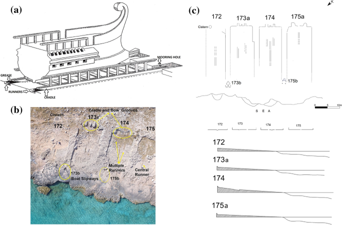
a Two rock-cut runners and the cradle with the ship (Drawing Dr.Semih Büyükkol). b Keel slots at slipways no 172 and 175 and multiple runners at no 173b and no 174 (Drone Photo Günay Dönmez)
-
2.
The ship is placed within the cradle whilst at sea and then slid through a fixed timber construction built on the slipway (Fig. 7a). This process was practiced as a kind of tradition on the Anatolian coast in the early twentieth century (Fig. 7b) and has continued until today. It may be that ships were hauled directly over the slipway itself if sufficiently greased. Many slipways on Dana Island display no keel slot or cradle runners on their floors (Fig. 7c). Similar rock-cut slipways are seen in Crete-Eulimna (Baika 2013a, b, c, d, 341- Fig. B8-1b), Israel-Tell Dor (Baika 2013a, b, c, d, 337-Fig. B7-2 based on Raban 1995, 308- Fig. 9.10), and Crete-Matalon (Gerding 2013, 389- Fig.B13.1)
Fig. 7 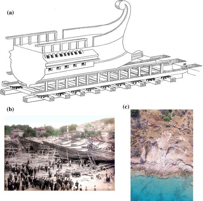
a Ship and cradle on the timber construction (Drawing Dr.Semih Büyükkol). b Cradles, oxens and ships at Yirmibeşoğlu Shipyard at Bartın of the Black Sea Coast (Photo: Archive of Murat Gül). c No keel slot at no 38b and no 39, keel slot at no 38a (Drone Photo Günay Dönmez
Some of these types of slipways on Dana Island also have grooves to fit both the forward end of the cradle and the underside of the ship’s bow. These examples show that these grooves were also used in slipways where runners were not available. A similar structure of this type was found on Tersane Bay in Turkiye’s Muğla province. There, the rock-cut slipway displays only one runner, similar to some of the examples on Dana Island. The structures at the end of the slipways have been described as "bollards....in the back wall" (Blackman 2014, 536). However, when compared to the examples on Dana Island, they may also represent grooves for the cradles.
-
3.
Vessels could be slid on their own keels and over the keel slot of the slipway (Fig. 8a, b). Similar slipways can be seen at Apollonia in Cyrenaica (Libya) (Baika 2013a, b, c, d. 299 Fig. B4-2), and Crete-Rhtymna (Baika 2013a, b, c, d, Fig. A12-9; Baika et.al 2016: poster). As described in the first bullet point, some of the slipways have three channels for one keel slot and two cradle runners. This type of slipway appears to be common and likely used to slide the ship on its keel or by the cradle method previously described.
Fig. 8 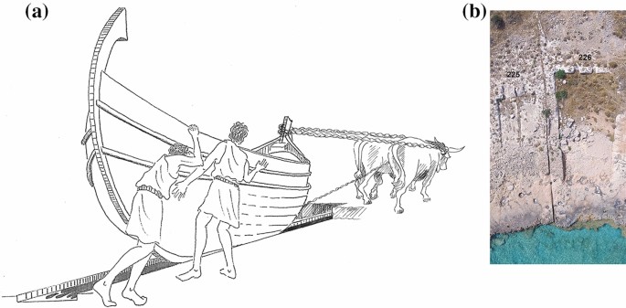
a Keel slot (Central Runner) and the ship (Drawing Dr.Semih Büyükkol). b Keel slot (Central runner) 225 and no visible runner at 226 (Drone Photo Ercan Soydan)
-
4.
Small ships may have been hauled over cylindrical logs located on the slipway (Fig. 9a, b). Although this process is more difficult than the others, it would, however, allow for a faster landing and launching of ships. The process involves the rearward logs being brought forward, as the ship is being towed forward. This method would require sufficient manpower to prevent the ship from tipping left and right. This particular hauling process is still in use at the coast of the Eastern Mediterranean and can be done on a ship’s keel or with the cradle.
Fig. 9 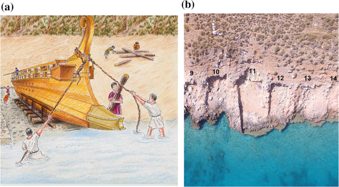
a Landing (left) or launching (right) operations of the ships on cylindrical logs (Drawing Dr.Semih Büyükkol). b Slipways (mainly they are at the east of the shipyard) flat ground (Drone Photo Günay Dönmez
-
5.
Apart from these, there are also small rock-cut structures unique to the island (Fig. 10a, b). These are probably small slipways for smaller boats, possibly tenders to the larger ships. They are mainly found between the larger slipways, though at least one example was seen behind a large slipway. These small rock-cut structures may yield evidence that the maintenance of the tenders and their mother ships was carried out simultaneously. A common feature shared by most of these structures indicates that the front parts of the boats were placed on a suitable rock-cut structure, and the lower middle and rear parts were supported by wooden posts. Almost all of these buildings have post holes indicative of this process.
Fig. 10 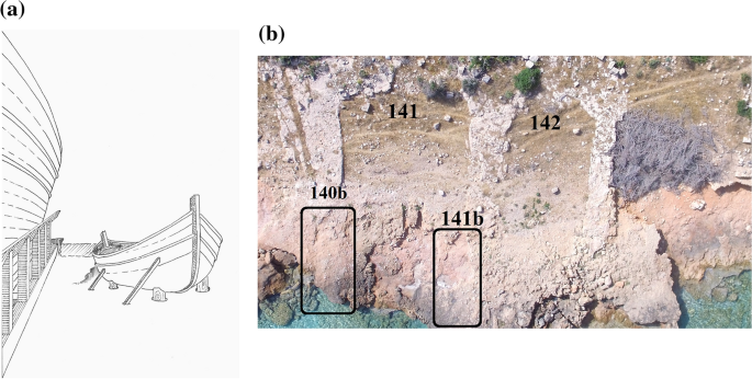
a Possible use of small rock-cut structures (Drawing Dr.Semih Büyükkol). b Small rock-cut structures number 140b and 141b (Photo Hakan Öniz)
-
6.
Apart from the ones mentioned above, there is another structure whose use is not fully understood (Fig. 11). It is thought that this structure, which is different from all the others in form, was built for small ships with rams. However, there is no empirical evidence to support this idea.
Fig. 11 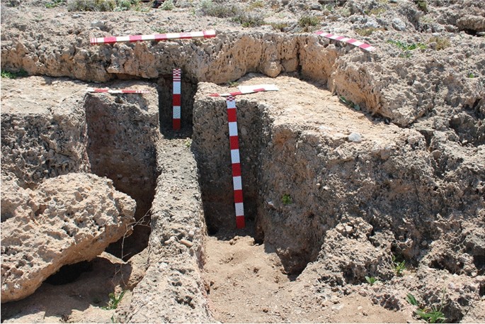
small rock-cut structure no 203b (Photo Hakan Öniz)


Certainly, the probable or confirmed 294 slipways hitherto discovered on Dana Island will increase with the archaeological excavations planned for the future. As mentioned above, many of the slipways are located on the slope of the 1500-m coastline along the northwest side of the island. The total number increases significantly if the many naturally eroded slopes are determined to be slipways. Typological differences in the slipways probably indicate use during different centuries, and under different management strategies regarding the hauling and launching methods employed. Such small rock-cut constructions, such as those at Dana Island, are rarely seen among the other known shipyards. These rare structures have interesting features that can give an idea about both boat maintenance and what past shipyards were like in the Mediterranean. Future excavations have the potential to shed even more light on these activities.
References
Aydıngün Ş (2021) The prehistoric strategic location of Dana Island, The greatest Shipyard of the Ancient Mediterranean (Ed. Hakan Öniz), Archaeopress, Oxford, pp 1–9
Baika K, Psarogiannis A, Tzigounaki A, Karamaliki N, Sarris A, Fischer P, Röth I, Reicherter KR, Dumas V, Papadopoulos NG, Cantoro G, Manataki M, Cuenca-García C, Kalayci T., Simon FX. Donati J, Simyrdanis K, Kalogeropoulos K, Chrysocheri E, Blackman D (2016) Interdisciplinary survey on the maritime installations of ancient Rithymna Archaeological and Geoarchaeological investigations, Poster Presentation at the Conference: 4th Meeting for the Archaeological Work in Crete, Rethymno
Baika K (2013) Eulimna (Alimnia), Shipsheds of the Ancient Mediterranean (Ed. David Blackman, Boris Rankov, Kalliopi Baika, Henrik Gerding, Jari Pakkanen) Cambridge University Press, New York, pp 340–348
Baika K (2013) Dor, shipsheds of the ancient mediterranean (Ed. David Blackman, Boris Rankov, Kalliopi Baika, Henrik Gerding, Jari Pakkanen) Cambridge University Press, New York, pp 335–339
Baika K (2013) Apollonia in Cyreniaica (Sozousa), Shipsheds of the Ancient Mediterranean (Ed. David Blackman, Boris Rankov, Kalliopi Baika, Henrik Gerding, Jari Pakkanen) Cambridge University Press, New York, pp 294–306
Baika K (2013) Small scale rock-cut naval bases, Shipsheds of the Ancient Mediterranean (Ed. David Blackman, Boris Rankov, Kalliopi Baika, Henrik Gerding, Jari Pakkanen) Cambridge University Press, New York, pp 231–253
Blackman D (2014) Ancient Shipsheds, Harbors and Harbor Cities in the Eastern Mediterranean, (Editors: S. Ladstätter – F. Pirson – T. Schmidts), BYZAS vol 19, pp 523–541
Blackman D (2013) Classical and hellenistic sheds, Shipsheds of the Ancient Mediterranean (Ed. David Blackman, Boris Rankov, Kalliopi Baika, Henrik Gerding, Jari Pakkanen) Cambridge University Press, New York, pp 16–29
Erginal AE, Öniz H, Erenoğlu O, Sarıaltun S (2021) An under-recognised geoarchaeological heritage asset in Turkey: Dana Island, Mersin. Geoheritage 13(4):88–98
Gavaz Ö (2021) Hittites and seafaring, The Greatest Shipyard of the Ancient Mediterranean (Ed. Hakan Öniz), Archaeopress, Oxford (26–33)
Gerding H (2013) Matalon (Matalai), Shipsheds of the Ancient Mediterranean (Ed. David Blackman, Boris Rankov, Kalliopi Baika, Henrik Gerding, Jari Pakkanen) Cambridge University Press, New York, pp 389–392
Hoeckmann O, Öniz H (2021) Ancient Shipsheds on Dana Island: some preliminary observations, Dana Island, The Greatest Shipyard of the Ancient Mediterranean (Ed. Hakan Öniz), Archaeopress, Oxford (36–49)
Kurt, M (2015) M.Ö. VI-V. Yüzyıllarda Kilikya Bölgesi: Küresel Güçler ve Syennesis Krallığı, Uluslararası Tarih Ve Sosyal Araştırmalar Dergisi - Tarihin Peşinde, 13: 303–326
Melchert, HC (2007) “The Borders of Tarhuntassa Revisite”, Belkıs Dinçol ve Ali Dinçol’a Armagan - VITA Festschrift in Honor of Belkıs Dinçol and Ali Dinçol (Editörler: Metin Alparslan, Meltem Dogan-Alparslan, Hasan Peker), Ege Yayınları, Istanbul, pp 507–514
Müseler W (2018) Das Geld der Strategen Pharnabazos und die Finanzen der persischen Kriegsflotte. JNG - Jahrbuch Für Numismatik Und Geldgeschichte 68:47–129
Müseler W (2021) Between Mesopotamia and Greece: Cultural influences in Cilician coin-iconography. Gephyra 22:69–133
Öniz H (2021) Dana Island Ancient Shipyard, Rough Cilicia: Archaeological Observations, The Greatest Shipyard of the Ancient Mediterranean (Ed. Hakan Öniz), Archaeopress, Oxford, pp 56–115
Raban A (1995) Dor-Yam: maritime and coastal installations at dor in their geomorphological and stratigraphic context – F. The Slipways, Excavations at Dor (Ed. E. Stern), Quedem Reports 1, Jerusalem, pp 307–310
Rankov B (2013) Slipping and launnching, shipsheds of the Ancient Mediterranean (Ed. David Blackman, Boris Rankov, Kalliopi Baika, Henrik Gerding, Jari Pakkanen) Cambridge University Press, New York, pp 102–123
Sayar M (2021) An ancient naval yard on the Southern Coast of Anatolia, the greatest shipyard of the Ancient Mediterranean (Ed. Hakan Öniz), Archaeopress, Oxford, pp 50–55
Sevketoglu M (2006) Cypro-anatolian relations in the 9th Millenium BC: Akanthou/Tatlısu Rescue Excavation, Anatolia-30, 119–136
Unal A (2021) The importance of the Southern Mediterranean Coast: Dana Island and its surroundings within the historical process, The Greatest Shipyard of the Ancient Mediterranean (Ed. Hakan Öniz), Archaeopress, Oxford, pp 12–24
Acknowledgements
The authors thank Dominic William Bush for supporting proofreading.
Funding
Open access funding provided by the Scientific and Technological Research Council of Türkiye (TÜBİTAK).
Author information
Authors and Affiliations
Contributions
HÖ wrote the main manuscript; SB drew all drawings and wrote technical explanations of the ship-hauling operations in the text. All authors reviewed the manuscript.
Corresponding author
Ethics declarations
Conflict of interest
The authors have no competing interests as defined by Springer, or other interests that might be perceived to influence the results and/or discussion reported in this paper.
Additional information
Publisher's Note
Springer Nature remains neutral with regard to jurisdictional claims in published maps and institutional affiliations.
Rights and permissions
Open Access This article is licensed under a Creative Commons Attribution 4.0 International License, which permits use, sharing, adaptation, distribution and reproduction in any medium or format, as long as you give appropriate credit to the original author(s) and the source, provide a link to the Creative Commons licence, and indicate if changes were made. The images or other third party material in this article are included in the article's Creative Commons licence, unless indicated otherwise in a credit line to the material. If material is not included in the article's Creative Commons licence and your intended use is not permitted by statutory regulation or exceeds the permitted use, you will need to obtain permission directly from the copyright holder. To view a copy of this licence, visit http://creativecommons.org/licenses/by/4.0/.
About this article

Cite this article
Öniz, H., Büyükkol, S. Rock-Cut Slipways and Slipping Techniques at Dana Island Shipyard. J Mari Arch (2024). https://doi.org/10.1007/s11457-024-09394-7
Accepted:
Published:
DOI: https://doi.org/10.1007/s11457-024-09394-7