
Abstract
During the last two decades, increasing use of full-coverage sonic mapping of the seafloor has made us more aware of the large and different number of seafloor processes and events bearing significant geohazard potential. This awareness combines with the increasing use of the seafloor for infrastructure and with the high density of population and settlement on the coast. Seafloor mapping is the first step in making a census of the geohazard-bearing features present in a given offshore area. It often provides the only tool for a comprehensive, although non-specific, seafloor geohazard assessment over large areas that are scarcely groundtruthed by acoustic prospection and seafloor sampling. However, the characterization of geohazard features on a morphological basis alone is limited, and more detailed investigations are needed to define the character and state of activity of potentially hazardous features. Such investigations include the use of deep-tow or autonomous platforms designed to acquire high-resolution data at depth as well as in situ measurements, both being very expensive activities not applicable over large areas. Thus seafloor mapping is often not only the first and the main but also the only tool for a comprehensive seafloor geohazard assessment.
This special issue represents an example of the diversity of approaches to seafloor geohazard assessment and summarizes the present state of this discipline. Both the diverse technologies applied and the specific aims of offshore geohazard assessment brought different communities to deal with the study of seafloor processes and events from remarkably distinct viewpoints. We identified three end members in offshore geohazard assessment: (1) geohazard assessment “sensu stricto”, (2) “engineering” geohazard assessment, (3) “non-specific” geohazard assessment. These are being conducted by industry, academia and public agencies in charge of civil protection and land-use planning and management. Understanding the needs and geohazard perception of the different groups is a necessary step for a profitable collaboration in such an interesting and rapidly developing field of marine geology.
Avoid common mistakes on your manuscript.
Introduction
In May 2009, an international conference on “Seafloor Mapping for Geohazard Assessment” was held in the charming location of the Giardini “La Mortella” in the volcanic island of Ischia (Naples Gulf, Italy) within the umbrella of the IGCP project 511 and the Italian National Project MaGIC (Marine Geohazards along the Italian Coasts). Ischia island was affected in the recent geological past by a massive sector collapse and debris avalanche (Chiocci and De Alteriis 2006; De Alteriis et al. 2010), whose deposits and scar morphology were the object of a pre-conference fieldtrip.
The conference brought together some hundred participants from 12 countries, representing the academic, industry, and public administration communities. The participants presented several case studies and discussed the state of the knowledge of geohazard assessment in the submarine domain, focusing especially on the use of seafloor mapping by multibeam echosounder data complemented by other geophysical and in situ data and measurements for the purpose of geohazard assessment (Chiocci et al. 2009).
Notably, about one third of the presentations were directly or indirectly linked to, and given by, representatives of industry and private companies working for geohazard offshore surveys, witnessing the applied nature of the topic. It was made evident early during the conference that industry and academia do not share the same point of view as to what represents a geohazard and what is simply a constraint for offshore activities (see further on “Geohazards in the marine realm”). This Special Issue resulting from the conference contribution aims, among other, to bridge the gap between academic research (with relatively little funding and relatively long-term development of research themes) and the industry practice (with spectacular, often very costly datasets focused on specific, applied issues, and with little time to carry out bibliographic comparisons and a comprehensive view of the study area). Both the Ischia conference and this volume cover different areas worldwide, with higher density in the Mediterranean Sea (Fig. 1).

Location of the study areas described in the articles of this volume (yellow dots). Further case histories presented at the Ischia Conference in May 2009 but not included in this volume are reported as red dots. Their extended abstracts are collected in Chiocci et al. (2009)
Seafloor morphology exploration in recent decades: seafloor mapping programs and offshore geohazard investigations
Because of the widespread and always increasing use of multibeam and other mapping techniques, marine geology is undergoing a very stimulating and active historical moment as the scientific community is flooded by a massive amount of extremely high-resolution morpho-bathymetric datasets that allow an unprecedented look at the seafloor. The impact of these data is tremendous, sometimes comparable with the effect that the production of the first bathymetric map of the ocean floor (Heezen and Tharp 1954; Heezen et al. 1959) exerted on the understanding of global tectonic processes that led to the comprehensive definition of plate tectonics. Thanks to multibeam mapping techniques, our ability to produce a nearly continuous bathymetric surface of the seafloor has revolutionized our understanding of marine morphodynamics. This has significantly changed the detail with which we can interpret seafloor tectonic and sedimentary processes at the origin of geohazards (Hughes Clarke et al. 1996).
Multibeam sonar instruments underwent rapid development during the 1980s (Farr 1980; Brown and Blondel 2008), although the number of surveys at sea using this technique was limited. Since the 1990s, better-performing systems have been used and technology improved to integrate acquisition of echosounding with backscatter (de Moustier 1988; Lurton 2002). Today, the modern swath mapping sonar systems usually collect concurrent swath bathymetry and acoustic backscatter data. When processed together, these data can be used for remote sensing of seafloor characteristics, with several applications in geotechnical and geohazard surveys (e.g., offshore drilling and mining, dredging and disposal, subsea cable and pipeline routes; de Moustier 2010).
It is only during the last 10–15 years that multibeam echosounders have become a common tool in any kind of subaqueous survey, from very shallow coastal and lacustrine environments to full ocean depths, providing increasing amounts of high-resolution data. These data constitute nowadays the unavoidable base for any geohazard assessment study. The use of AUVs and other near seafloor platforms has extended high-resolution surveys into deep water. In addition, bathymetric data extracted from 3D seismic volumes rival multibeam echosounders in horizontal resolution and allow the comparison of seafloor and buried seismic surfaces with a seismic geomorphology approach (Posamentier et al. 2007).
As far as seafloor geohazard is concerned, multibeam bathymetry is not only able to identify features representing the trace of hazardous geological processes, but may also precisely measure morphometric parameters and their variation through time, to enhance the monitoring of seafloor changes representing active processes. Multibeam bathymetry also provides boundary conditions and inputs to numerical modeling aiming to reproduce geological processes to make predictions for future scenarios (e.g., runout of sediment failures in tsunami modeling).
Obtaining a comprehensive seafloor map of homogeneous resolution at the regional, EEZ, and oceanic scale has been the focus of numerous initiatives. In the pre-multibeam era, large-scale seafloor mapping was first carried out using low-frequency, long-range side-scan sonar systems such as GLORIA (Geological Long-Range Inclined Asdic, Rusby and Revie 1975). A long-standing initiative to merge, collect, homogenize, and edit existing datasets of mainly single-beam soundings such as GEBCO (General Bathymetric Chart of the Oceans; Carpine-Lancre et al. 2003; Hall 2006) is being carried out with the support of international organizations (UNESCO, IHO) and national hydrographic offices.
In the multibeam era, several projects aimed to acquire full-coverage multibeam data for different purposes, such as the Norwegian Mareano (Thorsens 2009; Dolan et al. 2009), the California Seafloor Mapping Program (Ocean Protection Council 2007), the Irish INSS-INFOMAR (Irish National Seabed Survey), the mapping of the Spanish EEZ (Muñoz et al. 1998), the European MESH (Mapping European Seabed Habitats) and the Italian MaGIC (Marine Geohazard Along the Italian Coasts). At a Mediterranean scale, an effort to compile existing data in deep water is being made by CIESM and Ifremer (MediMap Group et al. 2005).
Geohazards in the marine realm
Kvalstad (2007) defined geohazard in the offshore domain, as “local and/or regional site and soil conditions having a potential of developing into failure events causing loss of life or damage to health, environment or field installations”. Such a definition is broad enough to include most of the geological processes shaping the seafloor, as no time frame is defined and potentially any modification of the seafloor may be damaging for structures resting on it.
Geohazards are one of the elements in the equation of geological risk. The geological risk (NGI 2005) is in fact the product of the probability of occurrence of a given geological event or process (geohazard), the vulnerability of a given area or region to this geohazard and the possible damaging consequences for humans, structures and/or the environment.
In marine and coastal environments, the major geological hazards are linked to the occurrence of events such as earthquakes, volcanic eruptions, submarine landslides or other rapid processes that are able to modify the morphology and character of the seafloor such as gravity-driven sediment flows, fluid emissions, bedform migration, retrogressive erosion at canyon heads, etc. (Fig. 2). Secondary effects such as tsunamis (either triggered by earthquakes or landslides) also need to be considered, as both their genesis and propagation are strongly controlled by seafloor morphology.

Cartoon summarizing the seafloor features linked to potentially hazardous geological processes. This figure depicts an idealized continental margin with both natural geohazard-bearing features and main anthropogenic structures lying on the seafloor
Although the definition of geohazards, though debatable, is relatively straightforward, their assessment is relatively complex. In fact, for the marine realm, it is often difficult if not impossible to define:
-
1.
The time scale of the hazard. Seafloor sector collapses and related debris avalanches are common processes in the millennial-scale geologic evolution of volcanic islands, and thus an event bearing an extremely high damage potential might recur in the future. However, do they have to be considered in a geohazard assessment if no signs of activity are present? In a similar way, retrograding canyon heads, which seldom affect the coastline, often show a clear match between subaerial and submarine erosional morphologies, showing that landslides shaped the coast inshore of the canyon head. The question is, therefore: should this be considered a geohazard if no signs of instability are detected but there is only the knowledge that a geological process could cause mass wasting in an undefined future?
-
2.
The capability of a given process to produce dangerous effects. Our knowledge of submarine processes is in many cases very limited. Do we have to assume a conservative approach (worst-case scenario) in any instance? For example, for landslide-generated tsunamis there are physical models linking the volume of the mobilized sediment and water depth to the tsunami wave height. Is it reasonable to consider all slide scars, caused by different failures (rotational, translational, complex, etc.), as a result of catastrophic events, when we do not know precisely the failure dynamics? What would be the result of the assessment if many or most of the failures were slow enough not to produce significant effects on the overlying water column?
-
3.
The recurrence time of most of the hazardous events. Sometimes only erosional scars evidence the occurrence of mass wasting in a given setting, thus hindering any possible definition of age and recurrence time of landslide events. For instance mass wasting at canyon heads is the main process for their genesis and retrogression, as witnessed by the multiple, complex and overlapping landslide scars that form it. However mass wasting there usually occurs with the complete disintegration of the failed mass and its transformation into gravity flows dispersing downcanyon. In this case we know that the process is frequent, but what does “frequent” mean?
-
4.
The frequency—magnitude relationship of observed geohazards. In addition to frequency-dependent attenuation, hull-mounted multibeam systems have an inherent loss of resolution with increasing water depth. Therefore, the capability to depict and characterize geohazard-bearing features is water depth-dependent. This problem is shown in Fig. 3 with an example of size distribution of submarine landslides in the Mediterranean basin with data compiled from the published literature (Camerlenghi et al. 2010). The fact that landslides appear to have a characteristic size-magnitude ratio probably reflects our inability to image small landslides (hundreds of m2 or less), and/or to a subjective underestimate by the operator (small = not hazardous?).
The impact of offshore geohazards for coastal communities is also depth-dependent, i.e., the deeper the geohazard-generating feature, the smaller the potential impact, so this somewhat counterbalances our inability to detect small geohazard features in deep water. However, the impact of geohazard processes for offshore infrastructure can be very high, also in deep water, no matter the size of the geohazard-generating feature. To confront this, industry is extensively using AUVs and ROV-mounted multibeam systems for seafloor mapping to achieve the high resolution of hull-mounted coastal surveys also in very deep waters.
Fig. 3 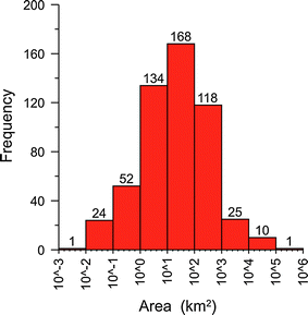
Frequency of magnitude (log-area) for submarine landslides from the landslide database (see Camerlenghi et al. 2010) in the Mediterranean basin showing incomplete view of distribution (i.e., smaller landslides are not picked in the distribution)
-
5.
The spatial distribution of hazardous events. In open slope settings, it is common practice to highlight features such as submarine landslides as evidence for geohazard, and pipeline and cable routes are often set to avoid these features. However, how likely is it that the next failure will occur over the same area where failure already occurred? Isn’t it more likely that the next failure will occur in a nearby area that shows no current signs of seafloor disturbance? In other words, is it a wiser decision to lay a pipeline through a submarine landslide scar or through an area that apparently shows no signs of recent failure but is near another area that failed?

Despite the above-mentioned limitations, geohazards have to be defined, depicted and evaluated because the use of the seafloor for settling structures continues to increase, as does the coastal population. Therefore, assessment of marine geohazards must be a key element in coastal and seafloor management. For instance, the ever-increasing use of the seafloor for cable route and drilling facilities (extending more and more into deep water), make marine geohazards a major concern for industries and public agencies dealing with marine infrastructures. Also onshore, for coastal communities and structures, marine geohazards may produce either direct effects such as submarine landslides retrogressively propagating onshore as in Finneidfjord in 1996 (Longva et al. 2003) or Stromboli in 2002 (Chiocci et al. 2008b) or indirect effects such as submarine landslides generating or contributing to tsunamis, as in Grand Banks in 1929 (Piper et al. 1999) or Nice in 1979 (Malinverno et al. 1988).
For geologically active regions (such as the Mediterranean, the Caribbean, and many regions around the Pacific belt of fire), which are often highly touristic regions, the risk is extremely high as the scenic coasts are often volcanic or fault-controlled and tourists and coastal settlements are packed into narrow coastal belts and constricted pocket beaches. In such a setting, even limited coastal landslides or tsunamis may have enormous effects, as evidenced by the 1979 Nice landslide and subsequent tsunami (Sultan et al. 2010).
Diverse approaches and characterizations of geohazard
One of the main outcomes of the Ischia conference and of this volume is the evidence that there are three end-member approaches in geohazard characterization that we hereafter refer to as (1) “geohazard assessment sensu-stricto”; (2) “engineering geohazard assessment” and (3) “non specific geohazard assessment” (Fig. 4).

Triangular diagram summarizing the different type of geohazard assessment and how the different communities relate to them. See text for details
The geohazard assessment sensu-stricto is the one conforming to the classical definition (see beginning of “Seafloor morphology exploration in recent decades: seafloor mapping programs and offshore geohazard investigations”) and is typical of applicative surveys as it is aimed to precisely identify one or more hazards in a specific site and the possibility that this hazard might occur in a given time span (see, for instance, L’Heureux et al. this volume, Strasser et al. this volume). This approach requires a precise knowledge of the character of the process/event considered hazardous, its recurrence time, the present state of the seafloor and subseafloor, and the factors controlling it. For instance, for a submarine landslide, knowledge of the state of stability of the slope (based on geomechanical character of the potentially failing mass) and the definition of possible triggers of the instability are needed.
The study should therefore rely on a suite of geophysical data and in situ measurements that make it very costly and only possible for small areas and limited numbers of features/hazardous processes. The outcome of the study, however, is not only a truthful assessment of the hazard but may also define the character of the infrastructure in order to reduce the vulnerability to the hazard. In this case, a real risk assessment is possible.
The engineering geohazard assessment considers that the presence of any uneven feature at the seafloor constitutes a geohazard in itself as it is a development constraint that may impact the seafloor structure, if not taken into due account. As an example, the presence of a rock outcrop or a slope-break at the seafloor is considered by the industry a geohazard to be avoided or carefully considered for operational planning of a cable or pipeline route to avoid free spans. In strict terms these uneven features (such as ridges or boulders) should not be considered real “geohazards” because by themselves they have no “potential of developing into failure events” (Kvalstad 2007). In other words, the hazard results from human action at the location of this feature without the feature itself necessarily developing into a failure event. Furthermore, in this approach, the time span considered for the assessment is usually comparable with the life span of the infrastructure at the seafloor (e.g., pipeline, submarine cable), generally not longer than a few decades and thus with a shorter return period than most geological processes (see, for example, Dyer, this volume, Cecchini et al. this volume).
Finally the non-specific geohazard assessment involves the census of potentially hazardous features present in a whole region without targeting any specific process/event and at any specific effect on exposed goods. Such assessment is aimed to define in a general perspective the presence and character of all the hazardous marine geological processes/events and possibly the seafloor and subseafloor predisposition to these processes/events. This approach does not attempt to define the precise age and recurrence period of the hazard; rather, it evaluates the spatial occurrence of hazardous events and highlights the possibility that similar events will occur in the future, given the similarity of the morpho-structural and lithostratigraphic setting of the surroundings.
In strict terms the “non-specific geohazard assessment” should not be considered as a real geohazard assessment, but, in our perception and given the present technology, is the only possible way to define at a regional scale the location, type, and characteristics of the geohazards present in a given region, with possible indication on their state of activity. Cost-efficient multibeam mapping is in this respect the fundamental tool for such assessment, which therefore relies essentially on geomorphic interpretation of high-resolution bathymetric data. Examples of this type of geohazard assessment are provided in Chiocci and Ridente (this volume), Larroque et al. (this volume), and Lo Iacono et al. (this volume).
Assessment of geohazards according to these three end-members is very clearly divided by the approach used by different communities when studying geohazards (Fig. 4). In fact, academia (universities and research institutes) moves between the “geohazard assessment sensu-stricto” and the “non-specific geohazard assessment” approaches, as it is mainly interested in understanding the processes and events both at small and large scale. Academic studies are often focused in small areas that are investigated in detail to characterize the seafloor and subseafloor. Academia is also interested in the overall geological evolution of continental margins and therefore the “non-specific geohazard assessment” is seen as a way to understand the processes shaping the seafloor and the relationship between processes and long-term morphological evolution.
On the contrary, industry moves between the “engineering geohazard assessment” and the “geohazard assessment sensu-stricto”, and often these two are performed in sequential order. The need to find the safest route or site for laying and installing structures at the lowest possible economic cost often means that even small seafloor features have to be considered in geohazard assessment, as they constrain the deployment of the structure.
Finally, stakeholders and public administrations (including geological surveys) are interested in the “non-specific geohazard assessment”, needed to wholly assess the risk for public goods in a given region and the “engineering geohazard assessment” approach needed for public works and land management.
Special Issue outline
Here follows a succinct outline of the contributions of the Special Issue, grouped by thematic affinity. Owing to the location of the conference venue, the majority of the contributions show case studies from European, and in particular Mediterranean, continental margins (Fig. 1). This fact also reflects the increased attention towards offshore geohazard assessment in this densely populated region and towards the management of marine areas and marine spatial planning, which is for the moment limited to the coastal areas (e.g., Schaefer 2009), but will impact in the near future entire regional seas or marine basins for activities where seafloor geohazards are relevant, including installations of offshore wind-powered turbines and offshore oil and gas activities (COM 2010).
Methodological aspects of offshore geohazard mapping
The first group of papers is devoted to generic aspects of seafloor mapping for geohazard purposes. Chiocci and Ridente (this volume) describe the efforts made by the Italian community in trying to produce regional maps of geohazard features, and the need to standardize cartographic representation amongst the diverse settings and parties involved in such an effort. Mosher (this volume) highlights the limitations of multibeam data and the risks of data over-interpretation resulting from system resolution problems. Along a similar line, Dyer (this volume) discusses a few cases of inappropriate data processing and how this had an impact on offshore installations.
Seafloor morphology and implications for geohazards
The second group of papers provides a few examples of how seafloor mapping techniques are useful in delineating zones of active geohazards, or excluding certain seafloor features as the source of potential geohazard. Urgeles et al. (this volume) perform a detailed analysis of prodeltaic bedforms that had been previously interpreted as indicative of early seafloor deformation. Cecchini et al. (this volume) discuss the seaforms on the eastern Sardinia-Corsica continental shelf that could represent a hazard for pipeline routing. Boudillon et al. (this volume), Ercilla et al. (this volume), Lo Iacono et al. (this volume) and Morelli et al. (this volume) depict the complex geomorphology and stratigraphic architecture of various continental margins and the implications of the structural and sedimentary-erosive features for geohazard assessment. Finally, Hough et al. (this volume) present an integrated and systematic map-based approach for the assessment and mitigation of seabed geohazards and risk to proposed deepwater development.
Faults and fluids
This section illustrates the utility of multibeam mapping, together with other geophysical techniques, in delineating active faults and fluid seepage structures. Larroque et al. (this volume) and Nomikou and Papanikolaou (this volume) provide two examples of recent fault activity in the Ligurian margin and Aegean Sea and show how multibeam mapping can help in redefining regional seismic hazard. Dalla Valle and Gamberi (this volume) provide evidence of interaction among fluid seepage, faulting, and mass-wasting. Léon and Somoza (this volume) present a GIS application to help identify marine geohazards derived from gas hydrate dissociation using seafloor mapping data.
Landslide identification, modeling and possible tsunami implications
The last section in this special issue presents a series of papers characterizing submarine slope failures and slope failure potential and how the morphometric parameters extracted from seafloor mapping and subsurface geophysical data help define the post-failure dynamics of these events and their consequent tsunamigenic potential. Migeon et al. (this volume) and Casas et al. (this volume) define various types of mass failure events and deduce the controlling factors in the development of the observed failures. Casalbore et al. (this volume) show the advantage of differential bathymetric surveys for depicting seafloor dynamic processes at the origin of geohazards. Mazzanti and Bozzano (this volume) use constraints from an historical event and observed seafloor morphology to test landslide propagation and tsunami generation models. Tinti et al. (this volume) and Argnani et al. (this volume) use morphometric parameters from a large sector collapse on the island of Ischia and the Eastern Adriatic Basin, respectively, to test worst-case tsunami scenarios for the adjacent Italian coasts. L’Heureux et al. (this volume) use multibeam bathymetric data together with additional geophysical and geotechnical data to clarify the sequence of events around the 1888 landslide and tsunami in the bay of Trondheim. Finally, Strasser et al. (this volume) present a new concept for evaluating basin-wide slope stability through time as a potential tool for regional seismic and tsunami hazard assessment.
Challenges in offshore geohazard mapping
Multibeam bathymetry probably offers the most cost-effective way to chart the ocean floor, yet this only portrays a static view of the seafloor. Marine sedimentary processes often occur over large time spans and/or at very low recurrence rates, and therefore this static view of the ocean floor depicts a series of potentially hazardous phenomena that are not active anymore or not representative of present day processes, particularly in formerly glaciated margins (see also cautionary note in Mosher, this volume). In active geodynamic settings or in areas close to sources of high sediment supply, the seafloor offers a much more dynamic environment, and differs greatly from one season to another. Repetitive surveys offer the opportunity to witness the processes at the origin of geohazards at work.
Programs are just being established to monitor seafloor dynamic systems using multibeam surveys. For example, Duffy and Hughes-Clarke (2005), Smith et al. (2005) and Hughes Clarke et al. (2009) have shown that using repetitive multibeam surveys it is possible to measure seafloor bedform migration. Knowledge of migration rate together with bedform height theoretically enables the calculation of bedload sediment transport within the migrating bedforms (Duffy and Hughes-Clarke 2005). The repetitive surveys also have broad application to monitoring mass-wasting phenomena, both in sedimentary and volcaniclastic environments, as already shown in Chiocci et al. (2008a), Hughes Clarke et al. (2009), Casalbore et al. (this volume), or affecting man-made structures (Dan et al. 2007; Li et al. 2009). A series of backscatter multibeam surveys has also been used to assess the impact on benthic ecosystems of hyperpycnal flows and related turbiditic deposition associated with major flood events (Urgeles et al. 2002).
Yet, for monitoring morphological change, the typical scale of spatial change must be greater than the total survey accuracy, which significantly limits our ability to monitor geohazard processes in deep sea environments. Due to survey accuracy issues, the scale of the apparent vertical difference is usually proportional to the slope of the seafloor (Hughes Clarke et al. 2009).
Repetitive surveys are often planned in an opportunistic manner, constrained by the availability of previous surveys and the occurrence of catastrophic events such as floods (e.g., Urgeles et al. 2002; Casalbore et al. this volume) or seafloor failures (Chiocci et al. 2008a). However, monitoring seafloor dynamic processes requires careful planning and some idea of the rate of seafloor change. Duffy and Hughes-Clarke (2005) and Hughes Clarke et al. (2009) already indicate that in order to track moving dunes, the time interval between surveys must be short enough for the dunes not to migrate more than half their spacing.
The common practice for geohazard assessment in the domain of offshore exploration includes a reiterative approach wherein geohazards are identified with repeated and more and more focused surveys. This includes the use of AUV-ROV seafloor surveys, also because of the need to identify potentially hazardous features at the scale of the planned seafloor infrastructures (Kvalstad 2007). Also academic research may take advantage from these new technologic developments. Migeon et al. (2011b) propose a closer look at the seafloor in the area of the 1979 Nice event with the use of an AUV with spatial resolution of 2 m (compared to the 25 m of the Simrad EM300 echosounder). Apart from the increased number of submarine landslide scars detected, the main advantage is the possibility to identify clearly the signature of retrogressive erosion and the traces of gravity flow transformations at meter scale, with implications for the understanding of the causal sedimentary processes.
The importance of groundtruthing remains in any case a key point in most common practice of geohazard assessment, especially when quantitative data are needed to support modeling (Morgan et al. 2009). The search for the crucial site from which to obtain in situ data is based on the use of swath bathymetry and seismic profiles: indirect geophysical data may actually guide the selection of significant measures, for example of sediment pore pressure to evaluate the possible effects of a recent earthquake (Sultan et al. 2008).
The increasing amount of data and the diversity of datasets in the offshore domain has already propelled the integration of large and complex datasets in Geographic Information Systems (GIS) as a current practice to evaluate the areal and size distribution of geohazards. Concerning the distribution of submarine landslides along entire continental margins, for example, a limited number of studies exist at large scale to evaluate if there is a scaling relationship between submarine landslide area/volume and frequency of occurrence, as is the case for earthquakes and their magnitude (e.g., Chaytor et al. 2009). In some cases mapping is supported by other analyses such as landslide susceptibility linked to seismic activity (Strasser et al. this volume), and susceptibility maps of submarine landslides and of fluid flow features related to possible controlling parameters (Léon and Somoza, this volume).
Finally, another need related to large seafloor datasets, especially when data have to be summarized in synthetic views, is the rapid analysis of the data with the application of automatic seafloor classifications (e.g., Atallah and Smith 2004). These approaches have the advantage of allowing some predictions to be made on the state of the seafloor that can be tested with successive surveys integrating additional techniques. The literature on this subject is sizeable and rapidly expanding (e.g., Hamilton 2005). Some attempts to compare different methods show that the success of a method in recognizing known patterns depends on the character of the seafloor morphology and its dominant grain size (Müller et al. 2007). The use of these techniques may serve as a guide to interpretation and a basis to formulate hypotheses, but it needs to be applied with caution and to be accompanied by control from independent data.
The increasing number of seafloor mapping studies at local and regional scale will certainly contribute to capture any inherent pattern in the signature of potentially catastrophic processes and thus provide enhanced seafloor geohazard assessment.
Conclusions
Seafloor geohazards are of increasing concern worldwide because of the accrued development of offshore and coastal facilities and growth of marine services’ exploitation. Assessment of seafloor geohazards involves several communities facing different interests and needs.
Technological development is offering marine geology powerful seafloor mapping tools, multibeam bathymetry above all; they are essential for geohazard characterization and, through repetitive surveys, monitoring and understanding of ongoing geological processes. Not only does high-resolution seafloor mapping enhance the assessment of marine geohazard, but it is also boosting the scientific knowledge on seafloor tectonic, erosional, and depositional processes.
The study of geohazard-bearing features provides an opportunity for collaborative activities between academia and industry as well as with public authorities in charge of land planning or civil defense. However, for the different communities, geohazard assessment has different objectives, time span, and required precision in forecast. Accordingly, we identify three types of geohazard assessment: sensu-stricto, engineering, and non-specific. Regardless of the different approach, seafloor mapping remains the unavoidable if not the main step in the geohazard assessment process.
For industry, focused in short time span and small areas, seafloor mapping is the first step in zoning the area of interest, in order to define the physical environment where the infrastructure will be lain and define geohazards that may recur during the life-span of the infrastructure. Seafloor mapping is also the base from which to plan further investigations and in situ measurements aimed to identify type, location, and possible timing of hazardous events.
For public authorities, seafloor mapping is the main tool to obtain a homogeneous product over vast offshore areas. Given the impossibility of achieving a precise (definite) assessment of geohazard for any seafloor feature, the assessment mainly relies on the identification of geomorphic features linked to hazardous processes/events that might re-occur in the future over the same area, without any specific indication of time and precise location. This assessment does not involve a specific indication of time or precise location of geohazard occurrence.
Finally, scientific research is interested in defining in detail the physical processes that shape the seafloor with the maximum possible resolution. However, seafloor mapping is also the primary tool to define the magnitude and type of processes occurring in a given area that are the key to interpreting the long-term morphostructural and stratigraphic evolution of the continental margins and ocean basins.
References
Argnani A, Tinti S, Zaniboni F, Pagnoni G, Armigliato A, Panetta D, Tonini R (2011) The eastern slope of the southern Adriatic basin: a case study of submarine landslide characterization and tsunamigenic potential assessment. Mar Geophys Res, this volume. doi:10.1007/s11001-010-9100-2
Atallah L, Smith PJ (2004) Automatic seabed classification by the analysis of sidescan sonar and bathymetric imagery. In: IEE proceedings. Radar, Sonar and Navigation 151:327–336
Budillon F, Conforti A, Tonielli R, De Falco G, Di Martino G, Innangi S, Marsella M (2011) The Bulgheria canyon-fan: a small scale, proximal, fluvial-like system in the eastern Tyrrhenian Sea. Mar Geophys Res, this volume. doi:10.1007/s11001-011-9138-9
Brown CJ, Blondel P (2008) Developments in the application of multibeam sonar backscatter for seafloor habitat mapping. Appl Acoust 70(12):1242–1247
Camerlenghi A, Urgeles R, Fantoni L (2010) A database on submarine landslides of the Mediterranean Sea. In: Mosher DC, Moscardelli L, Shipp RC, Chaytor JD, Baxter CDP, Lee HJ, Urgeles R (eds) Submarine mass movements and their consequences, advances in natural and technological hazards research, 28. Springer, Dordrecht, pp 491–501
Carpine-Lancre J, Fisher R, Harper B, Hunter P, Jones M, Kerr A, Laughton A, Ritchie S, Scott D, Whitmarsh M (2003) The History of GEBCO 1903–2003: the 100-year story of the General Bathymetric Chart of the Oceans. 140 pp, GITC bv, Netherlands, ISBN 90-806205-4-8
Casalbore D, Chiocci FL, Mugnozza GS, Tommasi P, Sposato A (2011) Flash-flood hyperpycnal flows generating shallow-water landslides at Fiumara mouths in Western Messina Straits (Italy). Mar Geophys Res. doi:10.1007/s11001-011-9128-y
Casas D, Ercilla G, Yenes M, Estrada F, Alonso B, García M, Somoza L (2011) The Baraza slide. Model and dynamics, Mar Geophys Res, this volume. doi:10.1007/s11001-011-9132-2
Cecchini S, Taliana D, Giacomini L, Herisson C, Bonnemaire B (2011) Preliminary results on submarine geo-hazards in the eastern Sardinia-Corsica continental margin. Mar Geophys Res, this volume. doi:10.1007/s11001-011-9126-0
Chaytor JD, ten Brink US, Solow AR, Andrews BD (2009) Size distribution of submarine landslides along the US Atlantic margin. Mar Geol 264:16–27
Chiocci FL, De Alteriis G (2006) The Ischia debris avalanche: first clear submarine evidence in the Mediterranean of a volcanic Island pre-historic collapse. Terra Nova 18(3):162–180
Chiocci FL, Ridente D (2011) Regional-scale geohazard assesment on Italian continental margins. The MaGIC project experience (Marine Geohazards along the Italian Coasts. Mar Geophys Res, this volume. doi:10.1007/s11001-011-9120-6
Chiocci FL, Romagnoli C, Bosman A (2008a) Morphologic resilience and depositional processes due to the rapid evolution of the submerged Sciara del Fuoco (Stromboli Island) after the December 2002 submarine slide and tsunami. Geomorphology 100:356–365
Chiocci FL, Romagnoli C, Tommasi P, Bosman A (2008b) The Stromboli 2002 tsunamigenic submarine slide: characteristics and possible failure mechanisms. J Geophys Res 113(B10):151–181
Chiocci FL, Ridente D, Casalbore D, Bosman A (eds) (2009) International conference on seafloor mapping for geohazard assessment, extended abstracts. Rendiconti Online Società Geologica Italiana 7: 152 pp. ISSN 2035-8008
COM (2010) 771 Maritime spatial planning in the EU–Achievements and future developments. http://ec.europa.eu/maritimeaffairs/pdf/com_2010_771_en.pdf, 10 pp
Dalla Valle G, Gamberi F (2011) Pockmarks and seafloor instability in the Olbia continental slope (Northeastern Sardinian margin, Tyrrhenian sea). Mar Geophys Res, this volume. doi:10.1007/s11001-011-9133-1
Dan G, Sultan N, Savoye B (2007) The 1979 Nice harbour catastrophe revisited: trigger mechanism inferred from geotechnical measurements and numerical modelling. Mar Geol 245:40–64
De Alteriis G, Insinga D, Morabito S, Morra V, Chiocci FL, Terrasi F, Lubritto C, Di Benedetto C, Pazzanese M (2010) Age of submarine debris avalanches and tephrostratigraphy offshore Ischia Island, Tyrrhenian Sea, Italy. Mar Geol 278(1–4):1–18
de Moustier C (1988) State of the art in swath bathymetry survey systems. Int Hydrogr Rev 65:25–54
de Moustier C (2010) Seafloor acoustic backscatter measurements with multibeam echosounders. In: Proceedings offshore technology conference, Paper Number 20866-MS. doi:10.4043/20866-MS
Dolan MFJ, Buhl-Mortensen P, Thorsens T, Buhl Mortensen L, Bellec VK, Boe R (2009) Developing seabed nature-type maps offshore Norway: initial results from MAREANO programme. Nor J Geol 89:17–28
Duffy GP, Hughes-Clarke JE (2005) Application of spatial cross-correlation to detection of migration of submarine sand dunes. J Geophys Res Earth Surface 110(F4). doi:10.1029/2004JF000192
Dyer JM (2011) Geohazard identification: the gap between the possible and reality in geophysical surveys for the engineering industry. Mar Geophys Res, this volume. doi:10.1007/s11001-011-9137-x
Ercilla G, Casas D, Vázquez JT, Iglesias J, Somoza L, Juan C, Medialdea T, León R, Estrada F, García-Gil S, Bohoyo F, García M, Maestro A, Farran M (2011) Imaging the recent sediment dynamics of the Galicia Bank region (Atlantic, NW Iberian Peninsula). Mar Geophys Res, this volume. doi:10.1007/s11001011-9129-x
Farr HK (1980) Multibeam bathymetric sonar: sea beam and hydro chart. Mar Geodesy 4(2):77–93
Hall JK (2006) GEBCO Centennial Special Issue–Charting the secret world of the ocean floor: the GEBCO project 1903–2003. Mar Geophys Res 27:1–5
Hamilton LJ (2005) A bibliography of acoustic seabed classification. DSTO, defence science and technology organisation, Australia, Technical report 27:11 pp
Heezen BC, Tharp M (1954) Physiographic diagram of the western North Atlantic. Geol Soc Am Bull 65:1261
Heezen BC, Ewing M, Tharp M (1959) The floors of the oceans: part I. The North Atlantic. Geol Soc Am Special Paper 65
Hough G, Green J, Fush P, Mills A, Moore R (2011) A Geomorphological mapping approach for the assessment of seabed geohazards and risk. Mar Geophys Res, this volume. doi:10.1007/s11001-010-9111-z
Hughes Clarke JE, Mayer LA, Wells DE (1996) Shallow-water imaging multibeam sonars: a new tol for investigating seafloor processes in the coastal zone and on the continental shelf. Mar Geophys Res 18:607–629
Hughes Clarke JE, Brucker S, Hill P, Conway K (2009) Monitoring evolution of fjord deltas n temperate and Arctic regions. Rendiconti Online Società Geologica Italiana 7:145–150
Kvalstad TJ (2007) What is the current “best practice” in offshore geohazard investigations? A state-of-the-art review. Offshore Technology Conference OTC 18545, 14 pp
Larroque C, Mercier de Lépinay B, Migeon S (2011) Morphotectonic and faults-earthquakes relationship along the northern Ligurian margin (Western Mediterranean) based on high resolution multibeam bathymetry and multichannel seismic-reflection profiles. Mar Geophys Res, this volume. doi:10.1007/s11001-010-9108-7
Léon R, Somoza L (2011) GIS-based mapping for marine geohazards derived from gas hydrate dissociation. Mar Geophys Res, this volume. doi:10.1007/s11001-011-9135-z
L’Heureux J-S, Glimsal S, Longva O, Hansen L, Harbitz CB (2011) The 1888 shoreline landslide and tsunami in Trondheimsfjorden, central Norway. Mar Geophys Res, this volume. doi:10.1007/s11001-010-9103-z
Li MZ, Parrott DR, Yang Z (2009) Sediment stability and dispersion at the black point offshore disposal site, Saint John harbour, New Brunswick, Canada. J Coast Res 25:1025–1040
Lo Iacono C, Sulli A, Agate M, Lo Presti V, Pepe F (2011) Submarine Canyons and slope failures in the Palermo Gulf (Southern Tyrrhenian Sea): implications for geo-hazard assessment. Mar Geophys Res, this volume. doi:10.1007/s11001-011-9118-0
Longva O, Janbu N, Blikra LH, Boe R (2003) The 1996 Finneidfjord Slide, seafloor failure and slide dynamics. In: Locat J, Mienert J (eds) Submarine mass movements and their consequences. Kluwer Academic Publishers, Dordrecht, pp 531–538
Lurton X (2002) An introduction to underwater acoustics principles and applications. Springer, London, p 347
Malinverno A, Ryan WBF, Auffret G, Pautot G (1988) Sonar images of the path of recent failure events on the continental margin off Nice, France. Geol Soc Am Special Paper 229, 59–75
Mazzanti P, Bozzano F (2011) Revisiting the 6th February 1783 Scilla (Calabria, Italy) landslide and tsunami by numerical simulation. Mar Geophys Res, this volume, doi:10.1007/s11001-011-9117-1
MediMap Group, Loubrieu B, Mascle J et al (2005) Morpho-bathymetry of the Mediterranean Sea. CIESM/Ifremer special publication, Atlases and Maps, two maps at 1:2,000,000 scale
Migeon S, Cattaneo A, Hassoun V, Larroque C, Corradi N, Fanucci F, Dano A, Mercier de Lepinay B, Sage F, Gorini C (2011a) Morphology, distribution and origin of recent submarine landslides of the Ligurian Margin (North-western Mediterranean): some insights into geohazard assessment. Mar Geophys Res, this volume. doi:10.1007/s11001-011-9123-3
Migeon S, Cattaneo A, Hassoun V, Dano A, Ruellan E (2011b) Failure processes and gravity-flow transformation revealed by high-resolution AUV swath bathymetry on the Nice continental slope (Ligurian Sea). In: Yamada Y, Kawamura K, Ikehara K, Ogawa Y, Urgeles R, Mosher D, Chaytor J, Strasser M (eds) Submarine mass movements and their consequences. Advances in Natural and Technological Hazards Research series. Springer, Dordrecht, The Netherlands (in press)
Morelli D, Cuppari A, Colizza E, Fanucci F (2011) Geomorphic setting and geohazard-related features along the Ionian Calabrian margin between Capo Spartivento and Capo Rizzuto (Italy). Mar Geophys Res, this volume. doi:10.1007/s11001-011-9130-4
Morgan JK, Silver E, Camerlenghi A, Dugan B, Kirby S, Shipp C, Suyehiro K (2009) Addressing geohazards through ocean drilling. Sci Drill 7:15–30
Mosher DC (2011) Geohazard mapping with multibeam sonar: resolution and the need for 3-D. Mar Geophys Res, this volume. doi:10.1007/s11001-010-9104-y
Müller RD, Eagles S, Hogarth P, Hughes M (2007) Automated textural image analysis of seabed backscatter mosaics: a comparison of four methods. In: Todd BJ, Greene HG (eds) Mapping the seafloor for habitat characterization. Geological Association of Canada, Special Paper 47:43–61
Muñoz A, Acosta J, Palomo C, Pardo de Domlebum M (1998) Hydrographic and oceanographic programme for the Spanish EEZ. EEZ Tech 2:71–75
NGI (2005) Offshore geohazards. Summary Report 20021023-2. 72 pp
Nomikou P, Papanikolaou D (2011) The Active Mandraki Fault Zone of Nisyros Volcano based on onshore and offshore data. Mar Geophys Res doi:10.1007/s11001-011-9119-z
OPC (2007) California Ocean Protection Council. http://www.opc.ca.gov/webmaster/ftp/pdf/agenda_items/20071025/07_seafloor mapping/1007COPC07_seafloor mapping.pdf
Piper DJW, Cochonat P, Morrison ML (1999) The sequence of events around the epicenter of the 1929 Grand Banks earthquake: initiation of debris flows and turbidity current inferred from sidescan sonar. Sedimentology 46:79–97
Posamentier HW, Davies RJ, Cartwright JA, Wood L (2007) Seismic geomorphology–an overview, Geological Society, London, Special Publication 277: 1–14
Rusby JSM, Revie J (1975) Long-range sonar mapping of the continental shelf. Mar Geol 19:41–49
Schaefer N (2009) The integrated EU maritime policy and maritime spatial planning–the way ahead. EMSAGG conference, 7–8 May 2009, 6 pp
Smith DP, Ruiz G, Kvitek R, Iampietro PJ (2005) Semiannual patterns of erosion and deposition in upper Monterey Canyon from serial multibeam bathymetry. Geol Soc Am Bull 117:1123–1133
Strasser M, Hilbe M, Anselmetti FS (2011) Mapping basin-wide subaquatic slope failure susceptibility as a tool to assess regional seismic and tsunami hazards. Mar Geophys Res, this volume. doi:10.1007/s11001-010-9100-2
Sultan N, Cattaneo A, Sibuet J-C, Schneider J-L, the Sumatra Aftershocks team (2008) Deep sea in situ excess pore pressure and sediment deformation off NW Sumatra and its relation with the December 26, 2004 Great Sumatra-Andaman Earthquake. Int J Earth Sci (Geol Rundsch). doi:10.1007/s00531-008-0334-z
Sultan N, Savoye B, Jouet G, Leynaud D, Cochonat P, Henry P, Stegmann S, Kopf A (2010) Investigation of a possible submarine landslide at the Var delta front (Nice continental slope, southeast France). Can Geotech J 47:486–496
Thorsens T (2009) MAREANO-an introduction. Nor J Geol 89:3
Tinti S, Chiocci FL, Zaniboni F, Pagnoni G, de Alteriis G (2011) Numerical simulation of the tsunami generated by a past catastrophic landslide on the volcanic island of Ischia, Italy. Mar Geophys Res, this volume. doi:10.1007/s11001-010-9109-6
Urgeles R, Locat J, Schmitt T, Hughes-Clarke J (2002) Spatial and temporal backscatter variations in the Saguenay Fjord: causes and relation with the July, 1996 Saguenay flood. Mar Geol 184:41–60
Urgeles R, Cattaneo A, Liquete C, De Mol B, Amblàs D, Sultan N, Trincardi F (2011) A review of undulated sediment features on Mediterranean prodeltas: distinguishing sediment transport structures from sediment deformation. Mar Geophys Res, this volume. doi:10.1007/s11001-011-9125-1
Acknowledgments
We acknowledge the Chief Editors of Marine and Geophysical Researches for their willing to publish a joint academic-industry contribution on seafloor mapping, and for their patience in following all the steps towards publication. This volume was partially supported by the UNESCO and IUGS through project IGCP-511 “Submarine Mass Movements and Their Consequences”, currently superseded by IGCP project 585, “Earth’s continental MARgins: aSsessing geoHAzard from submarine Landslides (E-MARSHAL; http://www.igcp585.org) and of MaGIC project “Marine Geohazards along the Italian Coasts” (www.magicproject.it). Finally, National Civil Protection Department of Italy and namely Prof. B. de Bernardinis, are acknowledged not only for the aid they gave to the Ischia conference and to the volume but for supporting the MaGIC Project (Marine Geohazards along the Italian Coasts, www.magicproject.it) that is boosting a new wave of marine geology researches among the Italian marine geology community.
Author information
Authors and Affiliations
Corresponding author
Rights and permissions
About this article
Cite this article
Chiocci, F.L., Cattaneo, A. & Urgeles, R. Seafloor mapping for geohazard assessment: state of the art. Mar Geophys Res 32, 1–11 (2011). https://doi.org/10.1007/s11001-011-9139-8
Published:
Issue Date:
DOI: https://doi.org/10.1007/s11001-011-9139-8