
Abstract
Vulnerability is the main construct in flood risk management. One of the most significant aims of flood vulnerability assessment is to make a clear association between the theoretical conceptions of flood vulnerability and the daily administrative process. Variety of approaches has been introduced to assess vulnerability therefore selection of more appropriate methodology is vital for authorities. The more accepted assessing methods can be categorized in four groups: curve method, disaster loos data method, computer modeling methods and indicator based methods. The purpose of this study is to review these methods and compare their benefits and drawbacks. The article concluded that the indicator-based approach gives more precise vision of overall flood vulnerability in each area rather than other approaches.
Introduction
The aim of this paper is to evaluate current knowledge on flood vulnerability assessment approaches. Floods are anticipated to happen more strictly and regularly in the future because of climate change, unplanned rapid urbanization, change in land use pattern, poor watershed management and decline recharge of groundwater by extension of impermeable surfaces in urban areas. This means that many urban areas across the globe are likely to be under serious threat of floods, the adverse impacts of which are already believed only next to that of earthquakes (BALABAN 2009). Managing flood with the aim of safety and wellbeing of people and their environment saving is one of the main responsibilities of city authorities in flood prone areas. For achieving this goal, vulnerability reduction and increasing resilience are significant approaches. One of the main steps in this process is measuring vulnerability to identify vulnerable areas (Takemoto 2011) and adopting effective measures. Indeed urban flood vulnerability is various in time to time and in diverse places because of environmental conditions, human activities, and the culture of society in face of the threats (Ahmad and Simonovic 2013). Increasing assessment methods and improving our understanding about flood risk vulnerability can support decision makers in decreasing damage and mortalities. Different assessing methods of flood vulnerability have been developed over the last few decades. This paper desires to investigate four groups of the more common methods.
In most cases, risk term has been defined in relation to the purposes of different science in which disaster management methods were required. Despite a lot of definitions in literature, the concept of risk with regard to “hazard” and “vulnerability” seems to be the most accepted in flood risk management so it is significant to know that “risk” is completely a human subject. This means floods are part of the hydrological cycle, but due to dispute natural function of river flood plains in transport water and sediment as a result of human land use, risk has increased (Schanze 2006). In studying flood risk, it is useful to classify floods to: (a) coastal floods which can occur on the coast and along the banks of large lakes; (b) river floods that occur seasonally when spring rains water fills river basins too quickly, and the river will overflow its banks; (c) flash floods are short-term floods in small region such as part of the city which kill and damage the most (Balica 2007). The main purpose of flood risk management is reduction these human loss and economic costs to acceptable level. It is not possible to avoid flood risks completely, so it is necessary to manage them. On the other word, flood management does not attempt to eliminate flood risk but its aim is mitigate them. Avoiding, reduction or shifting the impacts of flood through processes for mitigation and adaptation are flood risk management‘s main goal (UNISDR 2009). The main steps of risk management are:
-
Flood planning mitigation measures (preparedness-before disaster).
-
Response measures (during disaster).
-
Recovery (after disaster) (Tingsanchali 2012) (Fig. 1).
Fig. 1 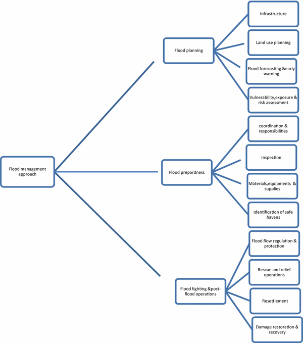
Food risk management process (Ali 2013)

In flood management subject there are two approaches for flood mitigation and protection:
Structural and non-structural; structural measures consist of infrastructure development like levees, dams or river dike that modifies the river flow (Faisal et al. 1999). The basic principles consist of storing; diverting and confinement of floods. Non-structural measures involve several mitigation measures not modifying the river flow. They include educating, reporting, warning and forecasting, assessing measures, emergency services, land use planning, flood insurance, Building codes, Health and social measures, public participation, etc.
Some studies declare that flood risk management (includes structural and non-structural measures) needs a complete ordered set of activities before and after hazard; Samuels (2006) suggests these activities as follows:
Pre-flood activities include:
-
Distinguish vulnerable areas
-
Disaster planning to found discharge paths, public service and infrastructure supplies for emergency actions
-
Construction of flood related infrastructure (physical structure and forecasting system)
-
Land-use planning and preventing unsuitable development in the flood plains
-
Awareness among the people exposed to flood
The post-flood activities:
-
Injuries relief
-
Reconstruction of damaged places
-
Recovery of the environment and the economic
-
Review of the flood management measures to advance the planning for future hazards
So flood risk management is assembling activities of several professionals such as hydrologists, hydraulic engineers, economists, social scientists, ecologists, and planners for reducing flood hazard impacts. In each of these areas there are different methods for assessing flood risk and its vulnerability. The repetition of risk assessments after flood mitigation measures (both structural and non-structural measures) lets appropriate judgment of the efficiency of each measure and also leads to identification of components of risk which need extra mitigation (Cutter 2003).
Flood vulnerability is one of the significant components in risk management and flood damage assessment. Since vulnerability is found to be the main reason of disasters, it seems necessary to develop our perception of the vulnerability (Klein 2004). Researches with vulnerability subject involves diverse descriptions for vulnerability; in United Nations’ description vulnerability is a degree of damage to a certain objects at flood risk with specified amount and present in a scale from 0 to 1 (no damage to full damage) (United nations 1982).
International Panel of Climate Change (IPCC) described vulnerability as the incapability degree of managing climate change and sea-level rise impacts (IPCC 1992). So many definitions of vulnerability appear in the literature. Table 1 shows some most important definition of vulnerability:
Regarding literature and previous studies the framework for culnerability analysis special in Sustainability Science represents vulnerability, with obvious attention to space, time, scale, and context into a conceptual framework that can be applied to vulnerability assessment (Turner 2003). Flood vulnerability is one of the significant components in risk management and flood damage assessment (Connor and Hiroki 2005). There are several methods which developed by Researchers for evaluate flood vulnerability. Nevertheless, flood threat is still very prevalent in spite of increased awareness about the vulnerability Birkmann (2007). This matter increases doubt about the effectiveness of vulnerability evaluation methods and their influence on flood mitigation and adaptation (Khan 2012). Vulnerability measurement is a complex process because it influenced by several environmental, economic, and social or even political elements in local scale (Jixi Gao 2007). In other words vulnerability is affected by numerous factors such as settlements conditions, infrastructure, authority’s policy and capacities, social inequities, economic patterns, etc. So flood vulnerability is varied for people in diverse circumstance (Pandey et al. 2010). Human systems are vulnerable to floods due to three vital aspects: Exposure, susceptibility and resilience. Exposure refers to people and their surroundings and every element present in flood prone area being exposed to the flood impacts as a subject to potential losses (UNISDR 2009). Susceptibility which Cardona et al. (2012) states is people, environment and infrastructure tendency to influence by a hazard because of fragility of community or ecosystem and Pelling et al. (2004) defines resilience, coping and adaptation ability of a system in addressing disaster stress. Instance the vulnerability of urban areas is reflection of the exposure and susceptibility of the city to flood risk and the resilience of that region to cope and recover from the flood effects (Smit 2006).
This paper is primarily based on literature on flood vulnerability indeed current paper reviewed relevant studies in flood vulnerability assessment and categorized their methodologies in four separate groups then compared approaches to decide what are the strengths and weaknesses of using each group with the purpose of assisting decision makers in flood prone areas.
Discussion
Flood vulnerability assessment
There are a variety of vulnerability assessment methods which are different in their vulnerability description, theoretical framework, variables and methodology. According to earlier works vulnerability assessment methods can be categorized in four distinct groups which are considered in this paper (Dapeng Huang 2012):
-
Vulnerability indicators method which adapted to use available data for providing a logical Image of the place vulnerability. This method is widely used in flood vulnerability studies and preferred by policy makers for its clarified vulnerability image over space, a depiction which aims to priorities measures and plan for the risk response in specified region. This group of methods depends on complicated indices with and without weighting, however, these methods also faced with considerable complexities related with standardization, weighting and aggregation methods. Uncertainty is one more struggle with this method. Since each additive layer includes a diverse variable, struggle about variable Interdependencies must be fixed. The best proposed solution for this concern is weighting variables to reduce their impact in forming a final expression (Lein 2010). Another weakness of model is the difficulties that the quantification of a number of social indicators poses to the calculation (Khan 2012). Regards to (Füssel 2010) there are two theory based (deductive) and data based (inductive) approaches for indicators selection in this method. Whereas these attitudes are different in methodology, together they make a better perception of the local vulnerability. The deductive approach is built on a theoretical framework for selecting appropriate indicators and considering their relationship while inductive approach selects indicators regards to statistical link with observed vulnerability consequences (e.g., mortality from floods). Because there is no clear definition in vulnerability consequences for the development of aggregated indices, data based approach is only useful for specific flood exposure systems. In fact development and testing an index in the circumstance where deal with short term instability is the significant limitation of all data-based indexes (Füssel 2009).
-
Vulnerability curve method. The relation between the flood risk and elements at risk can be studied by empirical damage or fragility curves. This approach is essentially founded on data from well-documented case studies so typically restricted to dwellings in a specific area. This group of method picks out a sample of items in each selected class and a list of possible subjects is arranged. The data for all samples of each component class is averaged and step-damage curves created. The subsequent stage-damage curves are for potential damage, although similar methods can be used to measure damages that happen immediately after a flood (real damage analyses). Method is based on actual damage survey so takes a lot of time and resource and the reliability of this method is less than others because it is not applicable for other regions.
-
Disaster loss data method. This method is constructed on data collection from real flood hazard and their usage such as a director to upcoming events this method is a simple approach but will be a little inaccurate Because of unevenly recorded data so result of these methods should be treated caution.
-
Modeling methods. Computer models can evaluate depth, elevation and velocity of flood with using frequency, magnitude and shape of the hydrograph. In order to computing flood inundation, one (1D) or two-dimensional (2D) models which are based on solutions of the full or approximate forms of the surface water equations are prevalent. These methods depend on detailed data about topographic, hydrographic and economic information in the study region for its accuracy. Economic loss information is intelligible for public in this method. Nevertheless in lack of sufficient data, models suffer significant irregularities which can lead to questioning assessment validity and mix up decision makers (Balica 2013). In Geographic information system-based vulnerability modeling (GIS) variables used as an input data those should geo-referenced and converted to raster format for the tangible analysis. This method of modeling can assess vulnerability in local scale more sensitive than other ones because considers specific local factors however can not describe a clear link between predicted map and the level of real flood damage (Lein 2010).
Indicator-based method, curve method, disaster loss data and models approach are diverse techniques for evaluating flood risk and vulnerability. Regards to these four distinct approaches, there is an imperative question: what are the benefits and difficulties of these approaches for policy makers. Table 2 summarized main strengths and weaknesses of these methods.
The objective of the study is to compare the existing assessment approaches and decide on the best method. Regarding this comparison, indicator-based assessment approach can be the greatest policy-making tool for raising public awareness, support governments in priority of budget allocation and managing the international organizations in directions of participation. However, the indicators and consequences depend on assumptions that cannot be validated from the observed data so approach uses a methodology that would let the experts to evaluate the vulnerability results depend on the system characteristics
Conclusion
Improving vulnerability measurement is a necessary initial stage towards studying its main causes and the formulation of more accurate descriptions that can better decrease loss of life, and possessions. Investigation of the flood vulnerability assessment methods mentions the following conclusions:
Indicator-based vulnerability assessments are common, but they are also challenged by reason of complications related with standardization, weighting and aggregation methods. Indicator based method does not measure flood risk directly, but contribute to evaluating flood risk. Vulnerability covers variety characteristics of risk such as social, environmental physical and economic. These group of methods provide a wider, a rapid, trustworthy evaluation of flood vulnerability in a specific geographical region, but is little difficult because accessibility of good data and number of the indicators are very hard to quantify specially social indicators so the main limitation in this approach is that measurement of vulnerability must reflect social processes besides material consequences that seems complex and with many connections that are difficult to pinning. Vulnerability is, therefore, not easily decreased to a solitary metric and is not easily calculable (Adger 2006). On the other hand, computer based modeling can assess vulnerability in local scale more sensitive than other ones because considers specific local factors, however, it has little validity in data scarcity situation.
References
Adger WN (2006) Vulnerability. Glob Environ Change 16:268–281
Ahmad SS, Simonovic SP (2013) Spatial and temporal analysis of urban flood risk assessment. Urban Water J 10(1):26–49. doi:10.1080/1573062X.2012.690437
Alexander DE (2002) Principles of emergency planning and management. Oxford University Press, Oxford
Ali A (2013) Indus basin floods mechanisms, impacts, and management. ADB (Asian development bank), Mandaluyong City
Balica SF (2007) Development and application of flood vulnerability indices for various spatial scales-master Thesis. UNESCO-IHE, Delft
Balica SF (2013) Parametric and physically based modelling techniques for flood risk and vulnerability assessment: a comparison. Environ Modelling Softw 41:84–92
Balica S, Wright NG (2010) Reducing the complexity of the flood vulnerability index. Environ Hazards 9:321–339
Birkmann J (2007) Risk and vulnerability indicators at different scales: Applicability, usefulness and policy implications. Environ Hazards 7:20–31
Borden KA, Schmidtlein MC, Emrich CT, Piegorsch WW, Cutter SL (2007) Vulnerability of US cities to environmental hazards. J Homel Secur Emerg Manag 27:4(2)
Cannon T (1994) Vulnerability analysis and the explanation of “natural” disasters. In: Disasters, development and environment, New York, p 19
Cardona OD, van Aalst MK, Birkmann J, Fordham M, McGregor G, Perez R, et al (2012) Determinants of risk: exposure and vulnerability coordinating lead authors: lead Authors: review editors: contributing authors: managing the risks of extreme events and disasters to advance climate change adaptation — a special report of working groups I and II of the intergovernmental panel on climate change (IPCC), pp 65–108
Connor RF, Hiroki K (2005) Development of a method for assessing flood vulnerability. Water Sci Technol 51:61–67
Cutter SL (2003) Social vulnerability to environmental hazards. Soc Sci Quart 84:242–261
Dapeng Huang RZ (2012) An assessment of multidimensional flood vulnerability at the provincial scale in China based on the DEA method. Nat Hazards 64:1575–1586
Faisal IM, Kabir MR, Nishat A (1999) Non-structural flood mitigation measures for Dhaka City. Urban Water 1(2):145–153
Füssel HM (2009) Review and quantitative analysis of indices of climate change exposure, adaptive capacity, sensitivity, and impacts. World bank
Füssel H-M (2010) How inequitable is the global distribution of responsibility, capability, and vulnerability to climate change: A comprehensive indicator-based assessment. Glob Environ Change 20:597–611
IPCC (1992) Fires assessment WMO/UNEP, overview and policymakers summaries
ISDR (2004) Living with floods, UN guidelines offer decision makers hope to reduce flood losses, water day (22 March). UN
Jixi Gao JE (2007) An assessment of flood hazard vulnerability in the Dongting Lake Region of China. Lakes & Reservoirs Research and Management 12:27–34
Khan S (2012) Vulnerability assessments and their planning implications: a case study of the Hutt Valley, New Zealand. Nat Hazards 64:1587–1607
Klein R (2004) Developing a method for addressing vulnerability to climate change and climate. An academic perspective, Expert Meeting, Bonn
Lein JK (2010) Hazard vulnerability assessment: How well does nature follow our rules? Environ Hazards 9:147–166
Menoni S, Pergalani F (1996) An attempt to link risk assessment with land use planning: arecent experience in Italy. Disaster Prev Manage 5:5–6
Mileti, D. (1999). Disasters by design: a reassessment of natural hazards in the United States. National Academies Press
Næss LO (2006) Data and processes linking vulnerability assessment to adaptation decision-making on climate change in Norway. Glob Environ Change 16:221–233
Nasiri H (2013) Flood vulnerability index as a knowledge base for flood risk assessment in urban area. Novel Appl Sci 2:269–272
Pandey AC, Singh SK, Nathawat MS (2010) Waterlogging and flood hazards vulnerability and risk assessment in Indo Gangetic plain. Nat Hazards 55:273–289
Pelling M et al (2004) Reducing disaster risk a challenge for development. United Nations Development Programme — Bureau for Crisis Prevention and Recovery. doi:10.1007/s003450050172
Samuels PG (2006) A European perspective on current challenges in the analysis of inland flood risks. Springer, Netherlands
Schanze J, Zeman E, Marsalek J (eds) (2007) Flood risk management: hazards, vulnerability and mitigation measures, vol 67. Springer
Smit BA (2006) Adaptation, adaptive capacity and vulnerability. Global Environ Change 16:282–292
Takemoto S (2011) Moving towards climate smarts flood management in Bangkok and Tokyo-Master thesis. Massachusetts institute of technology
Tingsanchali T (2012) Urban flood disaster management. Proced Eng 32:25–37
Turner BL (2003) A framework for vulnerability analysis in sustainability science. Proc Natl Acad Sci 100:8074–8079
Undp UN (2004) Reducing disaster risk. A challenge for development. Bureau for Crisis Prevention and Recovery (BRCP), New York
UNISDR (2009) Terminology on disaster risk reduction. Retrieved from The united nations office for disaster risk reduction
United Nations NY (1982) Proceedings of the seminars on flood vulnerability analysis and on the principles of floodplain management for flood loss prevention. Bangkok
Wisner B (2004) Chapter 1: The challenge of disasters and our approach. In: At risk: natural hazards, people’s vulnerability, and disasters. Routledge, London
Author information
Authors and Affiliations
Corresponding author
Rights and permissions
Open Access This article is distributed under the terms of the Creative Commons Attribution 4.0 International License (http://creativecommons.org/licenses/by/4.0/), which permits unrestricted use, distribution, and reproduction in any medium, provided you give appropriate credit to the original author(s) and the source, provide a link to the Creative Commons license, and indicate if changes were made.
About this article

Cite this article
Nasiri, H., Mohd Yusof, M.J. & Mohammad Ali, T.A. An overview to flood vulnerability assessment methods. Sustain. Water Resour. Manag. 2, 331–336 (2016). https://doi.org/10.1007/s40899-016-0051-x
Received:
Accepted:
Published:
Issue Date:
DOI: https://doi.org/10.1007/s40899-016-0051-x