A New Approach for Ground Filtering of Airborne Laser Scanning Data Using PointNet++ Zeynep AkbulutFevzi KarsliMustafa Dihkan Research Article 13 December 2023 Pages: 1 - 15
Comparing the Performance of Machine Learning Algorithms for Groundwater Mapping in Delhi Zainab KhanMohammad MohsinAteeque Ahmad Research Article 20 December 2023 Pages: 17 - 39
A Novel Pyramidal CNN Deep Structure for Multiple Objects Detection in Remote Sensing Images Khaled Mohammed ElgamilyM. A. MohamedMohamed Maher Ata Research Article 22 December 2023 Pages: 41 - 61
Use of Geostatistical Methods Involving Standard Deviation and Semivariogram to Assess the Accuracy of Water Surface Extraction by Supervised Classification Abdelhalim BendibMohamed Lamine Boutrid Research Article 28 December 2023 Pages: 63 - 77
Mapping Soil Characteristics: Spatio-Temporal Comparison of Land Use Regression and Ordinary Kriging in an Arid Environment Niloofar pirestaniMozhgan Ahmadi NadoushanRasool Zamani Ahmadmahmoudi Research Article 25 January 2024 Pages: 79 - 93
Hydrometeors Distribution in Intense Precipitating Cloud Cells Over the Earth’s During Two Rainfall Seasons Shailendra KumarJose Luis Flores‑RojasYamina Silva Research Article 25 January 2024 Pages: 95 - 111
Pansharpening Using IHS Method on Multi-sensor Data and Multiple Feature Extraction Using Modified Otsu Thresholding Vikash Kumar MishraRaghvendra KumarPramod Kumar Soni Research Article 25 January 2024 Pages: 113 - 126
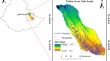
Entropy-Based Modelling for Flash Flood Hazard Mapping in Uttarakhand Himalaya Harshith Clifford PrinceC. M. BhattRaghavendra Pratap Singh Research Article 25 January 2024 Pages: 127 - 138
Assessment of Surface Water Quality Based on Landsat 9 Operational Land Imager Combined with GIS and IOT S. P. RajaveniN. MuniappanT. Praveen Kumar Research Article 27 January 2024 Pages: 139 - 151
Land Use/Land Cover Change Modeling and Evaluating the Spatiotemporal Dynamics of Highland Bamboo Species in the Southern Highland of Ethiopia Eshetu YirsawWondifraw Nigussie Research Article 29 January 2024 Pages: 153 - 165
Novel Malaria Risk Prediction and Mapping of Integrated Tribal Development Agency, Paderu Region, India, Using SAMRR Kodamala PrathyushaAluri Jacob Solomon RajuPeddada Jagadeewara Rao Research Article 30 January 2024 Pages: 167 - 187
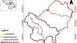
Identification of Suitable Sites for Water Harvesting Structures in Jamsholaghat Sub-basin Using GIS and Multi-Criteria Decision Analysis S. K. RayV. R. Desai Research Article 31 January 2024 Pages: 189 - 202
A Statistical Study on Cloud Base Height Behavior and Cloud Types During Southwest Monsoon over a High-Altitude Site in Western Ghats, India P. P. LeenaDhwanit J. MiseG. Pandithurai Research Article 02 February 2024 Pages: 203 - 217
Applicability of Utilizing Remote Sensing Rainfall Products Data in Arid and Semi-Arid Poorly Gauged Catchments: Study of Wadi Ghoweiba Watershed, Egypt Elsayed M. Abu El EllaAbdullah A. AbbasHassan I. Mohamed Research Article Open access 03 February 2024 Pages: 219 - 234
Aquifer Vulnerability Analysis Using the Original and Modified DRASTIC Method on Alluvial Aquifer Zones, Ethiopia Tesema Kebede SeifuTekalegn Ayele WoldesenbetTenalem Ayenew Research Article 03 February 2024 Pages: 235 - 249