Reality-based 3D documentation of natural and cultural heritage sites—techniques, problems, and examples Fabio RemondinoAlessandro Rizzi Review Open access 03 July 2010 Pages: 85 - 100
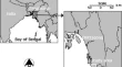
Application of remote sensing and GIS in the study of environmental sensitivity to desertification: a case study in Basrah Province, southern part of Iraq A. S. HadeelMushtak T. JabbarXiaoling Chen Original Paper Open access 19 June 2010 Pages: 101 - 112
Mapping tropical forest cover and deforestation using synthetic aperture radar (SAR) images M. Mahmudur RahmanJosaphat Tetuko Sri Sumantyo Original Paper Open access 23 July 2010 Pages: 113 - 121
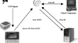
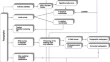
Development of track log and point of interest management system using Free and Open Source Software Daisuke YoshidaXianfeng SongVenkatesh Raghavan Original Paper Open access 23 July 2010 Pages: 123 - 135