Reservoir sedimentation and estimating dam storage capacity using bathymetry survey: a case study of Abrajit Dam, Upper Blue Nile basin, Ethiopia Mekash ShiferawRoman Abebe Original Paper 30 October 2020 Pages: 277 - 286
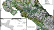
Application of various strategies and methodologies for landslide susceptibility maps on a basin scale: the case study of Val Tartano, Italy Vasil YordanovMaria Antonia Brovelli Original Paper Open access 09 November 2020 Pages: 287 - 309
Evaluation of the environmental impacts of urbanization from the viewpoint of increased skin temperatures: a case study from Istanbul, Turkey Behnam KhorramiHadi Beygi HeidarlouBakhtiar Feizizadeh Original Paper 06 January 2021 Pages: 311 - 324
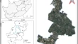
Three-dimensional building change detection using object-based image analysis (case study: Tehran) Fatemeh Tabib MahmoudiSharareh Hosseini Original Paper 07 January 2021 Pages: 325 - 332
Shoreline change monitoring for coastal zone management using multi-temporal Landsat data in Mahi River estuary, Gujarat State Krunal PatelRajmal JainManik H. Kalubarme Original Paper 17 January 2021 Pages: 333 - 347
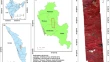
GIS- and AHP-based land suitability analysis of Malus domestica Borkh. (apple) in West Kameng district of Arunachal Pradesh, India Karma ChozomGibji Nimasow Original Paper 18 January 2021 Pages: 349 - 360
Potential of hyperspectral AVIRIS-NG data for vegetation characterization, species spectral separability, and mapping Shahbaz AhmadArvind Chandra PandeyNikhil V. Lele Original Paper 18 January 2021 Pages: 361 - 372
Classification of tree species in a heterogeneous urban environment using object-based ensemble analysis and World View-2 satellite imagery Simbarashe JomboElhadi AdamJohn Odindi Original Paper 20 January 2021 Pages: 373 - 387
Estimating maize lethal necrosis (MLN) severity in Kenya using multispectral high-resolution data Kyalo RichardElfatih M. Abdel-RahmanTobias Landmann Original Paper 21 January 2021 Pages: 389 - 400
The improvements of the Costa Rican ground-based gravity dataset as a result of a comprehensive attribute and spatial assessment of the historical databases Oscar H. LückeAlonso Vega FernándezJaime Garbanzo-León Original Paper 25 January 2021 Pages: 401 - 413
Analysis of the performance of closely spaced low-cost multi-GNSS receivers Chenyu XuePanos PsimoulisXiaolin Meng Original Paper Open access 26 January 2021 Pages: 415 - 435
Fifty years of the Friuli Venezia Giulia regional technical map: a best practice in the Italian cartographic context Fabio CrosillaGiovanni PicechAlberto Beinat Report 11 February 2021 Pages: 437 - 452
Performance evaluation of artificial neural networks for natural terrain classification Perpetual Hope AkwensiEric Thompson BrantsonYao Yevenyo Ziggah Original Paper 13 February 2021 Pages: 453 - 465
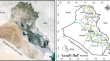
Modeling of spatially distributed infiltration in the Iraqi Western Desert Ahmed Shahadha MuneerKhamis Naba SaylAmmar Hatem Kamal Original Paper 02 March 2021 Pages: 467 - 479
COVID-19 prediction analysis using artificial intelligence procedures and GIS spatial analyst: a case study for Iraq Bashar Moneer YahyaFarah Samier YahyaRayan Ghazi Thannoun Original Paper 04 March 2021 Pages: 481 - 491