Abstract
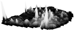
This paper develops a comprehensive approach to the definition of transportation analysis zones (TAZ), and therein, presents a new methodology and algorithm for the definition of TAZ embedded in geographic information systems software, improves the base algorithm with several local algorithms, and comprehensively analyses the obtained results. The results obtained are then compared to these presently used in the transportation analysis process of the Lisbon Metropolitan Area. The proposed algorithm presents a new methodology for TAZ design based on a smoothed density surface of geocoded travel demand data. The algorithm aims to minimise the loss of information when moving from a continuous representation of the origin and destination of each trip to their discrete representations through zones, and focuses on the trade-off between the statistical precision, geographical error, and the percentage of intra-zonal trips of the resulting OD matrix. The results for the Lisbon Metropolitan Area case study suggest a significant improvement in OD matrix estimates compared to current transportation analysis practises based on administrative units.


Notes
Developed in Geomedia Professional 5.1 (INTERGRAPH).
The thin plate spline is the two-dimensional analogue of the cubic spline in one dimension. It is the fundamental solution to the biharmonic equation. The name "thin plate spline" refers to a physical analogy involving the bending of a thin sheet of metal.
This value was obtained for the case study after calibration using different size grid cells.
The relative statistical error is presented in Eq. 2.
This value was obtained for the case study after calibration using different size grid cells.
The surrounding area size is a parameter of the algorithm that is defined by the user.
The concept of influence area of local “highest peaks” is defined as the minimum size that an analyst establishes for the specific modelling problem.
The core problem area parameter allows the analyst to establish different levels of relevance inside the modelling area, which does not need to be used. The default is the entire modelling area.
Subset containing zones with a statistical average equal to or less than 50%.
References
Amrhein, C.G.: Searching for the elusive aggregation effect—evidence from statistical simulations. Environ. Plan. A 27(1), 105–119 (1995)
Baass, K.G.: Design of zonal systems for aggregate transportation planning models. Transp. Res. Rec.—Travel. Demand. Forecast. Data. Consid. 807, 1–6 (1981)
Batty, M.: Spatial entropy. Geogr. Anal. 6(1), 1–31 (1974)
Batty, M.: Entropy in spatial aggregation. Geogr. Anal. 8(1), 1–21 (1976)
Batty, M., Sikdar, P.K.: Spatial aggregation in gravity models.1. An information-theoretic framework. Environ. Plan. A 14(3), 377–405 (1982a)
Batty, M., Sikdar, P.K.: Spatial aggregation in gravity models.2 One-dimensional population-density models. Environ. Plan. A 14(4), 525–553 (1982b)
Batty, M., Sikdar, P.K.: Spatial aggregation in gravity models.3. Two-dimensional trip distribution and location models. Environ. Plan. A 14(5), 629–658 (1982c)
Batty, M., Sikdar, P.K.: Spatial aggregation in gravity models.4. Generalizations and large-scale applications. Environ. Plan. A 14(6), 795–822 (1982d)
Bennion, M.W., O’Neill, W.A.: Building transportation analysis zones using geographical information systems. Trasp. Res. Rec.—Multimodal. Prior. Setting. Appl. Geogr. Inf. Syst. 1429, 49–56 (1994)
Binetti, M., Ciani, E.: Effects of traffic analysis zones design on transportation models. In: Proceedings of the 9th Meeting of the Euro Working Group on Transportation, Bari, Italy (2002)
Chang, K.T., Khatib, Z., Ou, Y.M.: Effects of zoning structure and network detail on traffic demand modeling. Environ. Plan. B-Plan. Des. 29(1), 37–52 (2002)
Chapleau, R.: Conducting telephone origin—destination household surveys with an integrated informational approach. In: Proceedings of the International Conference on Transport Survey Quality and Innovation, Grainau, Transportation Research Board (1997)
Chesbon, G., Cheryl, P.: Using GIS to define and develop TAZ data. In: Proceedings of the 4th International Conference on Microcomputers in Transportation, Baltimore, Maryland (1992)
Clark, W.A.V., Avery, K.L.: Effects of data aggregation in statistical-analysis. Geogr. Anal. 8(4), 428–438 (1976)
Crevo, C.C.: Impacts of zonal reconfigurations on travel demand forecasts. Transp. Res. Rec. 1477, 72–80 (1991)
Ding, C.: Impact analysis of spatial data aggregation on transportation forecasted demand. In: Proceedings of the Urban and Regional Information System Association (URISA) Conference, Washington DC, URISA (1994)
Ding, C.: The GIS-based human-interactive TAZ design algorithm: examining the impacts of data aggregation on transportation-planning analysis. Environ. Plan. B-Plan. Des. 25(4), 601–616 (1998)
Ding, C., Choi, K., Kim, T.J.: GIS-based traffic analysis zone design. In: Proceedings of the 3rd International Conference on Computers in Urban Planning and Urban Management, Atlanta (1993)
Eagleson, S., Escobar, F., Williamson, I.: Hierarchical spatial reasoning theory and GIS technology applied to the automated delineation of administrative boundaries. Comput. Environ. Urban. Syst. 26(2–3), 185 (2002)
Edwards, J.D.: Transportation planning handbook, 2nd edn. Institute of Transportation Engineers, Washington DC (1992)
Fotheringham, A.S., Rogerson, P.A.: GIS and spatial analytical problems. Int. J. Geogr. Inf. Syst. 7(1), 3–19 (1993)
Fotheringham, A.S., Wong, D.W.S.: The modifiable areal unit problem in multivariate statistical-analysis. Environ. Plan. A 23(7), 1025–1044 (1991)
Gan, C.-T.: A GIS-aided procedure for converting census data for transportation planning. ITE J.-Inst. Transp. Eng. 64(11), 34–40 (1994)
Goodchild, M.F.: Aggregation problem in location-allocation. Geogr. Anal. 11(3), 240–255 (1979)
Keane, M.: Size of region-building problem. Environ. Plan. A 7(5), 575–577 (1975)
Martínez, L.: “TAZ delineation and information loss in transportation planning studies”. MS Dissertation submitted in Department of Civil and Architecture, IST-Technical University of Lisbon, Lisbon, Portugal (2006)
Masser, I., Brown, P.J.B.: Hierarchical aggregation procedures for interaction data. Environ. Plan. A 7(5), 509–523 (1975)
Morphet, C.S.: A statistical method for the identification of spatial clusters. Environ. Plan. A 29(6), 1039–1055 (1997)
O’Neill, W.A.: Developing optimal transportation analysis zones using GIS. ITE J.-Inst. Transp. Eng. 61(12), 33–36 (1991)
Openshaw, S.: Optimal zoning systems for spatial interaction models. Environ. Plan. A 9(2), 169–184 (1977)
Openshaw, S., Rao, L.: Algorithms for reengineering 1991 census geography. Environ. Plan. A 27(3), 425–446 (1995)
Openshaw, S., Taylor, P.J.: A million or so correlation coefficients: three experiments on the modifiable areal unit problem. In: Wringley, N. (ed.) Statistical applications in the spatial sciences, pp. 127–144. Pion, London (1979)
Ortúzar, J., Willumsen, L.: Modeling transport, 3rd edn. Wiley, New York (2001)
Robinson, W.S.: Ecological correlations and the behavior of individuals. Am. Sociol. Rev. 5(3), 351–357 (1950)
Scott, A.J.: Combinatorial programming spatial analysis and planning. Methuen & Co., Ltd., London (1971)
Trepanier, M., Chapleau, R.: Object-oriented and totally disaggregate analysis of origin-destination household survey data. Can. J. Civ. Eng. 28(1), 48–58 (2001)
Viegas, J., Martínez, L., Silva, E.: Modifiable areal unit problem effects on traffic analysis zones delineation. Environ. Plan. B (2008). doi:10.1068/b34033
Ward, J.H.: Hierarchical grouping to optimize an objective function. J. Am. Stat. Assoc. 58, 236–244 (1963)
Wong, D., Amrhein, C.: Research on the MAUP: old wine in a new bottle or real breakthrough. Geogr. Syst. 3, 73–76 (1996)
Xie, Y.: The overlaid network algorithms for areal interpolation problem. Comput. Environ. Urban. Syst. 19(4), 287 (1995)
You, J.S., Nedovic, Z., Kim, T.J.: A GIS-based traffic analysis zone design: implementation and evaluation. Transp. Plan. Technol. 21(1–2), 69–91 (1997a)
You, J.S., Nedovic, Z., Kim, T.J.: A GIS-based traffic analysis zone design: technique. Transp. Plan. Technol. 21(1–2), 45–68 (1997b)
Acknowledgments
This research has been supported by the Portuguese National Science Foundation (FCT) since 2004. We thank the consultancy TIS.pt for providing support by making the LMA Mobility Survey (TIS, 1994) available and the software company INTERGRAPH for the Geomedia Professional 5.1 license.
Author information
Authors and Affiliations
Corresponding author
Rights and permissions
About this article
Cite this article
Martínez, L.M., Viegas, J.M. & Silva, E.A. A traffic analysis zone definition: a new methodology and algorithm. Transportation 36, 581–599 (2009). https://doi.org/10.1007/s11116-009-9214-z
Published:
Issue Date:
DOI: https://doi.org/10.1007/s11116-009-9214-z


