Evaluation of an open-source collaborative web-GIS prototype in risk management with students Zar Chi AyeMarie CharrièreMichel Jaboyedoff OriginalPaper 21 April 2016 Pages: 169 - 179
Spatial uncertainty in cluster detection Stephanie KleinschmidtAlan T. MurrayTony H. Grubesic OriginalPaper 26 April 2016 Pages: 181 - 189
Distributed agents for online spatial searches Elizabeth-Kate GullandSimon MoncrieffGeoff West OriginalPaper 02 May 2016 Pages: 191 - 202
Prototype of an open-source web-GIS platform for rapid disaster impact assessment Roya OlyazadehZar Chi AyeMarc-Henri Derron OriginalPaper 09 May 2016 Pages: 203 - 210
Results of an evaluation of augmented reality mobile development frameworks for addresses in augmented reality Victoria RautenbachSerena CoetzeeDanie Jooste OriginalPaper 09 May 2016 Pages: 211 - 223
Evaluating open source routing tools in vaccine delivery in Kano State, Northern Nigeria Kehinde Adebola Adewara OriginalPaper 11 May 2016 Pages: 225 - 234
GIS oriented service optimization for fecal sludge collection Mohammad Dalower HossainSarawut NinsawatYuttachai Sarathai OriginalPaper 13 May 2016 Pages: 235 - 243
Landmarks based route planning and linear path generation for mobile navigation applications Pasindu ChandrasekaraThejaka MahaulpathaNimalika Fernando OriginalPaper 16 May 2016 Pages: 245 - 255
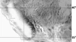
Estimation of glacial retreat and mass loss in Baspa basin, Western Himalaya Vinay Kumar Gaddam Anil V. KulkarniAnil Kumar Gupta OriginalPaper 20 May 2016 Pages: 257 - 266
NDVI signatures of regional in time and in space thermal anomalies in SW USA George Ch. Miliaresis OriginalPaper 27 May 2016 Pages: 267 - 277
Integration of soft computational simulator and strapdown inertial navigation system for aerial surveying project planning Ahmed. SerwaHossam H. El-Semary OriginalPaper 27 May 2016 Pages: 279 - 290
Lightweight urban computation interchange (LUCI): a system to couple heterogeneous simulations and views Lukas TreyerBernhard KleinChristine Meixner OriginalPaper Open access 31 May 2016 Pages: 291 - 302
UI proposal using modified diamond pairwise comparison diagram for fuzzy integral-based GIS–MCDM Jeong-Ki YooMin Soo Kim OriginalPaper 16 June 2016 Pages: 303 - 311
Efficient in-memory processing for huge amounts of heterogeneous geo-sensor data Min-soo KimIn-sung Jang OriginalPaper 16 June 2016 Pages: 313 - 322
Future technology developments and policy directions for the V-World open platform Byeongsun KimMinwoo JeongDongbin Shin OriginalPaper 16 June 2016 Pages: 323 - 333
Field management system for green tea utilizing on-site remote sensing technique Byungdug JunKenshi ToraoEung-Nam Kim OriginalPaper 21 June 2016 Pages: 335 - 345
How does railroad track closure affect housing values? The case of Seoul, Korea Chul SohnGeon Hu Kim OriginalPaper 28 June 2016 Pages: 347 - 354
Performance evaluation of CDN method in V-World web service as spatial information open platform service Han-sol JangJun-hee GoIn-sung Jang OriginalPaper 28 June 2016 Pages: 355 - 364
Erratum to: Estimation of glacial retreat and mass loss in Baspa basin, Western Himalaya Vinay Kumar GaddamAnil V. KulkarniAnil Kumar Gupta Erratum 17 June 2016 Pages: 365 - 365