Quantitative Analysis of Mixed Pixels in Hyperspectral Image Using Fractal Dimension Technique Ajay Kumar PatelJayanta Kumar Ghosh Research Article 01 September 2020 Pages: 1237 - 1244
A Novel Harris Feature Detection-Based Registration for Remote Sensing Image Yali WangHuicheng LaiLiejun Wang Research Article 08 September 2020 Pages: 1245 - 1252
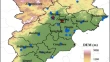
Application of Landsat 8 OLI for Mapping the Deccan Traps of Kachchh, Gujarat Shreekumari PatelParas Solanki Research Article 01 September 2020 Pages: 1253 - 1263
Satellite-Based Study of Seasonal Variability in Water Quality Parameters in a Tropical Estuary along the Southwest Coast of India Mallika BhuyanChiranjivi JayaramK. Ajith Joseph Research Article 02 September 2020 Pages: 1265 - 1276
Comparison of Six Machine Learning Methods for Estimating PM2.5 Concentration Using the Himawari-8 Aerosol Optical Depth Xin ZuoHong GuoXiaochuan Zhang Research Article 05 September 2020 Pages: 1277 - 1287
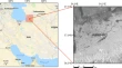
Flood Mapping Using Relevance Vector Machine and SAR Data: A Case Study from Aqqala, Iran Alireza Sharifi Research Article 01 September 2020 Pages: 1289 - 1296
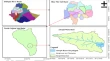
Investigating the Effect of Lockdown During COVID-19 on Land Surface Temperature: Study of Dehradun City, India Sandeep MaithaniGarima NautiyalArchana Sharma Research Article 05 September 2020 Pages: 1297 - 1311
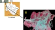
Examining Reservoir Sedimentation and Estimating Dam Stockpiling Limit Utilizing Bathymetry Overview: A Contextual Investigation of Abrajit Dam, North Gojjam Sub-basin, Blue Nile basin, Ethiopia Mekash ShiferawRoman Abebe Research Article 05 September 2020 Pages: 1313 - 1323
Extraction of Buildings in Urban Area for Surface Area Assessment from Satellite Imagery based on Morphological Building Index using SVM Classifier R. AvudaiammalP. ElaveniVijayarajan Rajangam Research Article 10 September 2020 Pages: 1325 - 1344