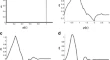
A New Component Scattering Model Using Polarimetric Signatures Based Pattern Recognition on Polarimetric SAR Data Mohsen JafariYasser MaghsoudiMohammad Javad Valadan Zoej Research Article 09 January 2016 Pages: 297 - 306
Identification of Suitable Natural Calibration Test Site for the Calibration of IRS Optical Sensors Shailendra S. SrivastavaYogdeep DesaiB. Kartikeyan Research Article 11 January 2016 Pages: 307 - 319
Geospatial Approach for National Level TOF Assessment Using IRS High Resolution Imaging: Early Results G. S. PujarV. K. DadhwalC. S. Jha Research Article 18 January 2016 Pages: 321 - 333
Polarimetric SAR Data Correction and Terrain Topography Measurement Based on the Radar Target Orientation Angle B. SouissiM. Ouarzeddine Research Article 21 January 2016 Pages: 335 - 349
Manifold-Preserving Common Subspace Factorization for Feature Matching Weidong YanShaoJun ShiJinhuan Wen Research Article 22 January 2016 Pages: 351 - 361
Spectral Response of Potato Crop to Accumulative Moisture Stress Estimated from Hydrus-1D Simulated Daily Soil Moisture During Tuber Bulking Stage Dibyendu DuttaPrabir Kumar DasVinay Kumar Dadhwal Research Article 25 January 2016 Pages: 363 - 371
Wavelet Based Feature Extraction Techniques of Hyperspectral Data N. PrabhuManoj K. AroraR. Balasubramanian Research Article 29 January 2016 Pages: 373 - 384
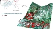
Identification of Potential Habitat Patches for Connectivity Using Weighted Linear Combination (WLC) and Integral Index of Connectivity (IIC) at East Godavari District, Andhra Pradesh, India Shanthala Devi B. SM. S. R MurthyC. S. Jha Research Article 01 February 2016 Pages: 385 - 394
Combining Genetic Algorithm with PDEs for Improving the Performance of Statistical Region Merging Based Object Extraction Amin ZehtabianHassan Ghassemian Research Article 06 February 2016 Pages: 395 - 407
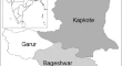
Use of Geospatial Tools to Prioritize Zones of Hydro-Energy Potential in Glaciated Himalayan Terrain Lydia SamAnshuman BhardwajRajesh Kumar Research Article 06 February 2016 Pages: 409 - 420
Extraction of Oil Spill Information Using Decision Tree Based Minimum Noise Fraction Transform Bingxin LiuYing LiXueyuan Zhu Short Note 08 January 2016 Pages: 421 - 426
Situational Adaptation of Spatial Data in On-Board Geographic Information Systems Vladislav Alexandrovich AndrosovKonstantin Vadimovich MalynkinAnna Nikolaevna Tikhomirova Short Note 11 January 2016 Pages: 427 - 433
Inconsistencies of SEBS Model Output Based on the Model Inputs: Global Sensitivity Contemplations Mohamed Elhag Short Note 11 January 2016 Pages: 435 - 442
SAR Image Change Detection Method Based on Pulse-Coupled Neural Network Rui LiuZhenhong JiaNikola Kasabov Short Note 25 January 2016 Pages: 443 - 450
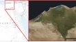
Mine Wastes Environmental Impact Mapping Using Landsat ETM+ and SPOT 5 Data Fusion in the North of Tunisia Nouha MeznedNada MechrguiSâadi Abdeljaouad Short Note 03 February 2016 Pages: 451 - 455
Identification of Black Spots on Highway with Kernel Density Estimation Method H. A. S. SandhuGyanendra SinghRajiv Chauhan Short note 03 February 2016 Pages: 457 - 464
A fast and effective algorithm based on improved hough transform Ren DongfengWang QiubingSun Fujun Short Note 05 February 2016 Pages: 465 - 469
Texture Measurement Through Local Pattern Quantization for SAR Image Classification Debasish ChakrabortyDibyendu DuttaJaswant Raj Sharma Short Note 06 February 2016 Pages: 471 - 477
Disappearance of the New Moore Island from the Southernmost Coastal Fringe of the Sundarban Delta - A Case Study Sugata HazraAnirban MukhopadhyayTuhin Ghosh Short Note 06 February 2016 Pages: 479 - 484