ISAR Image Reconstruction with Heavily Corrupted Data Based on Normal Inverse Gaussian Model Saeed JafariFarokh Hodjat KashaniAyaz Ghorbani Research Article 31 October 2018 Pages: 1 - 12
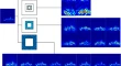
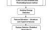
Building Damage Detection of the 2004 Nagapattinam, India, Tsunami Using the Texture and Spectral Features from IKONOS Images G. Sumilda MerlinG. Wiselin Jiji Research Article 28 October 2018 Pages: 13 - 24
Preliminary studies on corner reflectors responses as seen in Sentinel-1A images over Kanakapura region Nathiya Onisi KirubanandamGarudachar Raju Research Article 22 November 2018 Pages: 25 - 32
Automated Retrieval of Snow/Ice Surface Broadband Albedo in Beas River Basin, India Using Landsat-8 Satellite Images and Validation with Wireless Sensor Network Data Dhiraj Kumar SinghHemendra Singh GusainNeena Gupta Research Article 28 October 2018 Pages: 33 - 44
Assessment of Land Cover Changes Using Taguchi-Based Optimized SVM Classification Approach Mohammad ZareNegin BehniaDonalds Gabriels Research Article 28 October 2018 Pages: 45 - 52
A Comparative Study of Machine Learning Techniques to Simulate Land Use Changes Mohammad AhmadlouMahmoud Reza DelavarMohammad Karimi Research Article 10 November 2018 Pages: 53 - 62
Joint Probability Integral Method and TCPInSAR for Monitoring Mining Time-Series Deformation Meinan ZhengKazhong DengJun Feng Research Article 28 November 2018 Pages: 63 - 75
Microwave Emissivity Studies of Land Cover around Kanakapura Region Using High Spatial Resolution SAPHIR M. P. VasudhaG. Raju Research Article 28 October 2018 Pages: 77 - 89
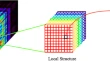
Spectral Tensor Synthesis Analysis for Hyperspectral Image Spectral–Spatial Feature Extraction Ronghua YanJinye PengDesheng Wen Research Article 28 October 2018 Pages: 91 - 100
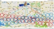
Application of a Geographic Information System to Analyze Traffic Accidents Using Nantou County, Taiwan, as an Example Jau-Ming SuYu-Ming WangPei-Ju Wu Research Article 02 November 2018 Pages: 101 - 111
Ensemble Classification of Hyperspectral Images by Integrating Spectral and Texture Features Haiyong DingXiaoying WangHaibin Luo Research Article 30 October 2018 Pages: 113 - 123
Translate SAR Data into Optical Image Using IHS and Wavelet Transform Integrated Fusion Wenyuan ZhangMin Xu Research Article 29 October 2018 Pages: 125 - 137
Modeling Urban Growth Trajectories and Spatiotemporal Pattern: A Case Study of Lucknow City, India Anugya ShuklaKamal Jain Research Article 31 October 2018 Pages: 139 - 152
Oasis Landscape Pattern Dynamics in Manas River Watershed Based on Remote Sensing and Spatial Metrics Bin WangYanxia LiLi Liu Research Article 09 November 2018 Pages: 153 - 163
Rational Polynomial Coefficients Modeling and Bias Correction by Using Iterative Polynomial Augmentation Bhaskar DubeyB. KartikeyanManthira Moorthi Subbiah Research Article 01 November 2018 Pages: 165 - 175
Development of Regional Algorithm to Estimate Suspended Sediment Concentration (SSC) Based on the Remotely Sensed Reflectance and Field Observations for the Hooghly Estuary and West Bengal Coastal Waters J. Selvin PitchaikaniR. RamakrishnanA. S. Rajawat Research Article 02 November 2018 Pages: 177 - 183