Identifying urban neighborhoods with higher potential for social investment using GIS-FIS approach Hossein AghajaniAli Alizadeh-Zoeram Original Paper 27 May 2020 Pages: 1 - 13
Urban land cover and morphometric analysis for flash flood vulnerability mapping and riparian landscape conservation in Kebena River watershed, Addis Ababa Asfaw MohamedHailu Worku Original Paper 30 May 2020 Pages: 15 - 28
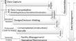
Categorisation of building data in the digital documentation of heritage buildings Ahmed KhalilSpyridon StravoravdisDietmar Backes Original Paper Open access 01 June 2020 Pages: 29 - 54
Regional modeling of soil sensitivity to water erosion in JIJEL region (Algeria) using MCA and GIS Soumeya Atika NehaiMohamed Saïd GuettoucheDjouher Saadoud Original Paper 10 June 2020 Pages: 55 - 70
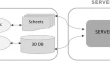
Web 3D: a CityGML viewer for cross-domain problem resolution Marina ÁlvarezJavier Fco. RaposoMiguel Barbero Original Paper 22 June 2020 Pages: 71 - 87
A novel unsupervised change detection method from remotely sensed imagery based on an improved thresholding algorithm Sara KhanbaniAli MohammadzadehMilad Janalipour Original Paper 22 June 2020 Pages: 89 - 105
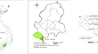
GIS-based simulation for deep-water port site selection using analytic hierarchy process: a case study from Southern East of Vietnam Thi-My-Trinh NguyenDinh-Thanh NguyenNguyen-Anh Doan Original Paper 03 July 2020 Pages: 107 - 118
Comparison of two different methodologies for correcting refraction in vertical angles K. NikolitsasE. Lambrou Original Paper 07 July 2020 Pages: 119 - 129
Challenges in the deep learning-based semantic segmentation of benthic communities from Ortho-images G. PavoniM. CorsiniP. Cignoni Original Paper 14 July 2020 Pages: 131 - 146