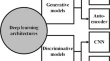
A hybrid deep learning–based model for automatic car extraction from high-resolution airborne imagery Mehdi Khoshboresh MasoulehReza Shah-Hosseini Original Paper 06 August 2019 Pages: 107 - 119
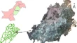
Towards a Web GIS-based approach for mapping a dengue outbreak Muhammad A. ButtA. KhalidA. Khalid Original Paper 08 August 2019 Pages: 121 - 131
Channelling participation into useful representation: combining digital survey app and collaborative mapping for national slum-upgrading programme Trias AdityaAeny SugiantoSuryani Amin Original Paper 15 August 2019 Pages: 133 - 148
Prediction of traffic accidents hot spots using fuzzy logic and GIS Aslam Al-OmariNawras ShatnawiTasneem Miqdady Original Paper 03 December 2019 Pages: 149 - 161
A geospatial analysis of land use dynamics and its impact on land surface temperature in Siliguri Jalpaiguri development region, West Bengal Ivana HoqueSmt. Kabita Lepcha Original Paper 03 December 2019 Pages: 163 - 178
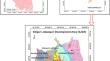
Assessing and mapping water erosion-prone areas in northeastern Algeria using analytic hierarchy process, USLE/RUSLE equation, GIS, and remote sensing Ali MihiNoureddine BenarfaAbdelkrim Arar Original Paper 03 December 2019 Pages: 179 - 191
Analysis of municipal solid waste collection using GIS and multi-criteria decision aid Louati AmalLe Hoang SonHanene Lahiani Original Paper 07 December 2019 Pages: 193 - 208
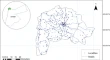
Geospatial disease risk modeling for the identification of potential areas of encephalitis in a subtropical region of India: a micro-level case study of Gorakhpur tehsil Nutan TyagiSantanu Sahoo Original Paper 17 December 2019 Pages: 209 - 223
Mountain summit detection with Deep Learning: evaluation and comparison with heuristic methods Rocio Nahime TorresPiero FraternaliDarian Frajberg Original Paper 24 December 2019 Pages: 225 - 246