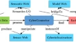
CyberConnector: a service-oriented system for automatically tailoring multisource Earth observation data to feed Earth science models Ziheng SunLiping DiLi Lin Research Article 19 July 2017 Pages: 1 - 17
Predicting future urban impervious surface distribution using cellular automata and regression analysis Wenliang LiChangshan WuWoonsup Choi Research Article 21 July 2017 Pages: 19 - 29
A novel decision support system for the interpretation of remote sensing big data Wadii BoulilaImed Riadh FarahAmir Hussain Research Article 05 August 2017 Pages: 31 - 45
Corner points localization in electronic topographic maps with deep neural networks Luan DongFengling ZhengQin Yan Research Article 05 September 2017 Pages: 47 - 57
Spatial autocorrelation of Neogene-Quaternary lava along the Snake River Plain, Idaho, USA A. DavarpanahH. A. BabaieD. Dai Research Article 08 September 2017 Pages: 59 - 75
Classify-normalize-classify Cesar SalgadoMaciel ZorteaJacob Scharcanski Research Article 15 September 2017 Pages: 77 - 97
Land use and land cover change and implication to watershed degradation by using GIS and remote sensing in the Koga watershed, North Western Ethiopia Amare SewnetGebeyehu Abebe Research Article 15 September 2017 Pages: 99 - 108
Uncertain spatiotemporal data modeling and algebraic operations based on XML Luyi BaiXingru CaoWeijia Jia Research Article 19 September 2017 Pages: 109 - 127
Exploring UAV in Indonesian cadastral boundary data acquisition Sheilla Ayu RamadhaniR. M. BennettF. C. Nex Methodology Article 19 August 2017 Pages: 129 - 146
Estimating leaf chlorophyll contents by combining multiple spectral indices with an artificial neural network Pudong LiuRunhe ShiWei Gao Methodology Article 05 September 2017 Pages: 147 - 156
Erratum to: Estimating leaf chlorophyll contents by combining multiple spectral indices with an artificial neural network Pudong LiuRunhe ShiWei Gao Erratum 15 September 2017 Pages: 157 - 157