SAR image analysis techniques for flood area mapping - literature survey R. Manavalan Review Article 16 October 2016 Pages: 1 - 14
Iterative selective spatial variance reduction of MYD11A2 LST data George Ch. Miliaresis Research Article 16 September 2016 Pages: 15 - 27
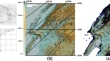
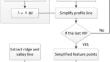
DEM generalization with profile simplification in four directions Tianwu MaYonggang ChenChunju Yang Research Article 24 October 2016 Pages: 29 - 39
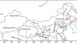
Spatiotemporal characteristics of TOMS-based dust aerosol optical depth in northern China during 1978–2005 Xiaoyu RenYun XieGuoyu Ren Research Article 27 October 2016 Pages: 41 - 53
Organizing earth observation data inside a spatial data infrastructure Markus InnerebnerArmin CostaBartolomeo Ventura Research Article Open access 09 November 2016 Pages: 55 - 68
Free multi-floor indoor space extraction from complex 3D building models Qing XiongQing ZhuYun Li Research Article 25 November 2016 Pages: 69 - 83
Toward cyberinfrastructure to facilitate collaboration and reproducibility for marine integrated ecosystem assessments Stace E. BeaulieuPeter A. FoxMichael Fogarty Research Article 10 December 2016 Pages: 85 - 97
Vectorization of classified remote sensing raster data to establish topological relations among polygons Bin XuJianping ChenPingping Yu Methodology Article 12 October 2016 Pages: 99 - 113
HNC-Plot: an excel VBA for visualization of helium, nitrogen and CO2 isotope data of crustal and mantle gases Hüseyin KarakuşHarun Aydin Software Article 21 September 2016 Pages: 115 - 125
CondMerg: an open source implementation in R language of conditional merging for weather radars and rain gauges observations D. GuenziS. FratianniR. Cremonini Software Article 26 October 2016 Pages: 127 - 135