
Abstract
The Briançonnais Domain (Western Alps) represented the thinned continental margin facing the Piemonte-Liguria Ocean, later shortened during the Alpine orogeny. In the external part of the External Briançonnais Domain (Zone Houillère), the Palaeozoic basement displays microdioritic intrusions into Carboniferous sediments and andesitic volcanics resting on top of the Carboniferous sediments. These magmatic rocks are analysed at two well-known localities (Guil volcanics and Combarine sill). Geochemical data show that the two occurrences belong to the same calc-alkaline association. LA-ICP-MS U–Pb ages have been obtained for the Guil volcanics (zircon: 291.3 ± 2.0 Ma and apatite: 287.5 ± 2.6 Ma), and the Combarine sill (zircon: 295.9 ± 2.6 Ma and apatite: 288.0 ± 4.5 Ma). These ages show that the calc-alkaline magmatism is of Early Permian age. During Alpine orogeny, a low-grade metamorphism, best recorded by lawsonite-bearing veins in the Guil andesites, took place at about 0.4 GPa, 350 °C in the External Briançonnais and Alpine metamorphism was not able to reset the U–Pb system in apatite. The Late Palaeozoic history of the Zone Houillère is identical to the one recorded in the Pinerolo Unit, located further East in the Dora-Maira Massif, and having experienced a garnet-blueschist metamorphism during the Alpine orogeny. The comparison of these two units allows for a better understanding of the link between the Palaeozoic basements, mostly subducted during the Alpine convergence, and their Mesozoic covers, generally detached at an early stage of the convergence history.
1 Introduction
In western and central Europe, crustal shortening associated with Variscan orogeny mainly took place during the Early and early Late Carboniferous. In latest Carboniferous to the earliest Permian times (i.e. ‘Stephanian’ to ‘Autunian’), however, a drastic change of the tectonic regime occurred, with crustal extension or transtension becoming dominant. This change is best documented by (i) the installation of numerous small-scale Basin-and-Range type basins (so called Permo-Carboniferous basins) in the previously thickened domain (e.g. Lorenz and Nicholls 1976; Ménard and Molnar 1988), and (ii) by the development of large-scale volcano-sedimentary deposits unconformably covering Variscan structures since the earliest Permian, displaying intermediate and acidic volcanics. Given the lack of good biostratigraphic markers in the 50 Ma-long history of the Permian, such volcanic rocks provide valuable geochronological markers for constraining the evolution of the European crust in the Permian (e.g. Pellenard et al. 2017; Ducassou et al. 2019).
While at first sight Permian magmatism appears to be widespread all-over Western Europe, heterogeneities occur, both spatially and temporally. In a recent synthesis about the Western Alps, Ballèvre et al. (2018) pointed out that Permian magmatism is widespread in the internal domains of the belt, i.e. in the basement of the Briançonnais paleogeographical domain (referred to as Briançonnais Domain in the following) representing the European passive margin towards the Piemonte-Liguria Ocean and in the Sesia-Dent Blanche and South-Alpine domains of the opposite passive margin. In contrast, it is very sparsely found in the external paleogeographic domains (External Massifs); these basement complexes are characterized by Carboniferous-age magmatism leading to the widespread intrusion of Carboniferous granitoids. Concerning the Briançonnais Domain in Liguria some authors pointed to the existence of two post-Variscan magmatic cycles of Permian age (e.g. Cortesogno et al. 1998). This contribution investigates in detail the suspected Permian magmatism in the type-area of the Briançonnais Domain (referred to as External Briançonnais in the following) located along a continuous transect between the Pelvoux External Massif and the Dora-Maira Internal Massif (Fig. 1) with the aim to (i) further constrain extent and timing of such magmatism within the various paleogeographic domains, and (ii) determine to which of the two postulated Permian cycles this magmatism may belong.

Simplified structural map of the SW Alps (modified from Bigi et al. 1990), showing the location of the studied samples (red stars close to Guillestre, and Briançon). Two other samples from the Pinerolo Unit have been studied previously (Manzotti et al. 2016; also located with red star) and will be used for comparison. The cross-section displays, at crustal scale, a potential interpretation of the well-known surface structures at depth
This study therefore investigates late Palaeozoic magmatism in the basement of the external part of the Briançonnais Domain near Briançon, which represented a more proximal part of the former European palaeomargin facing the Piemonte-Liguria Ocean. In this area, late Palaeozoic magmatism is represented by numerous microdioritic dykes and sills intruding the Carboniferous sediments from the “Zone Houillère”, and by a few volcanics. Our analysis concentrates on two of the most famous and easily accessible sites, namely the volcanics from the Guil valley, and a sill located close to the city of Briançon. Our geochronological study uses the LA-ICP-MS on both zircon and apatite. Given the high closure temperature for the U–Pb system in zircon (> 900 °C: Cherniak and Watson 2000), we expect to obtain magmatic ages. By contrast, the much lower closure temperature for apatite (c. 450–550 °C: Cherniak et al. 1991) represents a challenge for dating, because moderate Alpine metamorphism could have reset the apatite clock.
This main part of the study concerns the Palaeozoic basement of an external part of the Alpine nappe pile derived from the Briançonnais passive margin. The most internal unit of the Western Alps transect, i.e. the Dora-Maira Massif, exposes a window below high-pressure metamorphic oceanic units (i.e. M. Viso unit). It has been postulated that the structurally lowest unit within the Dora Maira window, the Pinerolo Unit that escaped eclogite facies metamorphism (Bousquet et al. 2012), may be largely made up of Permo-Carboniferous deposits typical for the Zone Houilllère of the External Briançonnais (Novarese 1898; Michard 1977; Manzotti et al. 2014). However its Mesozoic cover is not preserved and became detached. Hence, we will also discuss the original links between detached Mesozoic successions now outcropping in the External Briançonnais and parts of their former basement potentially preserved in the Dora-Maira Massif.
2 Geological setting
In the Western Alps, the Briançonnais Domain is a segment of thinned continental crust located between the partly oceanic Valaisan Basin to the West and the Piemonte-Liguria Ocean to the East (Schmid et al. 2004, 2017). This continental ribbon derived from Europe has been shortened and accreted to the more external European palaeomargin during the final stages of the building of the orogenic prism (from Late Eocene to Early Oligocene) (e.g. Tricart 1980, 1984). Crustal shortening was associated with high pressure–low temperature metamorphism, increasing in intensity from West (greenschist facies) to East (blueschist and eclogite facies) (Saliot 1973; Michard et al. 2004; Bousquet et al. 2008, 2012).
In the southern part of the Western Alps (Fig. 1), the Briançonnais Domain is classically divided into two different zones. To the West and directly adjacent to the Penninic Front (e.g. Ceriani et al. 2001), a narrow, elongated and arcuate zone essentially consists of stacked cover nappes defining the Briançonnais Zone s.str., the External Briançonnais in Figs. 1 and 2 (Termier 1903; Gignoux and Moret 1938; Debelmas 1955; Gidon 1962). A more internal part of the Briançonnais Zone (i.e. the La Chapelue and Chateau Queyras slices in Fig. 2 that are part of the Internal Briançonnais) is dominated by east-verging late stage backfolds and backthrusts that often invert the original nappe stack, bringing Briançonnais derived thrust sheets over ophiolites and associated sediments derived from the Piemonte-Liguria Ocean such as the M. Viso ophiolites. Still further to the East and structurally below these ophiolitic units, are the Mesozoic slivers of the Val Grana and Val Maira that are parts of the Internal Briançonnais (Fig. 1), which overlie a window of mostly basement-derived continental slices that constitute the Dora-Maira Massif (Vialon 1966; Michard 1967; Sandrone et al. 1993), considered to also have been part of the Briançonnais passive margin in terms of their former paleogeographic position by many authors. The link between these two sectors—both possibly belonging to the Briançonnais Domain in their paleogeographic position—will be discussed in detail later.

Simplified cross-section of the Briançonnais Domain along the Guil valley. The colour code is the same as in Fig. 1. The upper part (i.e. above sea-level) of the section closely follows Debelmas et al. (1966) and Kerckhove et al. (2005). The lower part (i.e. below sea-level) is intended to display a potential geometry of the nappe stack at depth. The normal fault displacement along the Durance Fault, which offsets the basal Briançonnais Thrust, is drawn according to Debelmas (1955) and Tricart et al. (1996), and may have been accompanied by a strike-slip displacement. The pre-Triassic basement, made of Carboniferous sediments and Permian volcanics, is only poorly exposed west of the Durance Fault, but preserved north of the section considered here. Permian sediments, formerly considered as a granite (Kerckhove and Piboule 1999; Kerckhove et al. 2005), occur in a narrow fault-bounded slice along the Durance Fault (Plan-de-Phazy). The largest outcrop of Permian andesites studied here is located in the Lower Unit of the External Briançonnais (Fig. 3). Note that backfolding and backthrusting inverted the original nappe stack, bringing the units of the Internal Briançonnais over calcschists and minor ophiolites derived from the Piemonte-Liguria Ocean
A classic section across the Briançonnais Zone s.str. is offered by the Ubaye valley (Debelmas and Gidon 1958; Gidon 1962; Michard and Henry 1988; Gidon et al. 1994) and by the Guil valley (Kilian 1899; Termier 1903; Goguel 1950; Lemoine 1961a) (Fig. 2). West of a major set of normal-transcurrent faults (the Durance Fault: Debelmas 1955; Tricart et al. 1996), the Mesozoic sequences of the External Briançonnais are sliced into several subunits (Roche-Charnière, Champcella), thrust over Late Cretaceous-Palaeocene flysch sequences of the Prealpine nappes (Fig. 1). The classic section across the Briançonnais Zone offered by the Guil valley east of the Durance fault is characterized by the stacking of several sub-units (i.e. nappes) (Fig. 2) (Kilian 1899; Termier 1903; Blanchet 1934; Gignoux and Moret 1938; Goguel 1943; Lonchampt 1962, Debelmas et al. 1966; Debelmas 1983). In the western part of the section (External Briançonnais), the nappe stack is deformed by open upright folds. The lower unit of the External Briançonnais exposes the Palaeozoic basement of the Mesozoic sequence. In the eastern part of the section (i.e. within the Internal Briançonnais), nappes essentially consist of detached Mesozoic covers. They are deformed by east-verging anticlines, and are found in an overturned position lying on top of the metasediments and associated metaophiolites of the Piemonte-Liguria Ocean of originally more internal origin due to back-thrusting (Fig. 2).
2.1 Volcanics in the Guil valley
The section across the External Briançonnais in the Guil valley displays several superposed units (Figs. 2 and 3). On top of the nappe stack, slices of detached cover differ in detail regarding the Triassic-Eocene sequence. For example, the Peyre-Haute nappe has a thick Norian dolomitic layer at its base, while the Font-Sancte nappe displays Anisian-Ladinian limestones, but Norian limestones are missing. The lower unit of the Guil valley at the bottom of the nappe stack is exposed in two windows (Fig. 3). The oldest sediments are greyish sandstones attributed to the Carboniferous (Lonchampt 1961; Debelmas 1983). A thick sequence (about 150 m) of reddish to purple andesites crops out on top of these sediments (Fig. 4). The volcanic rocks are succeeded by laterally discontinuous conglomerates displaying abundant volcanic clasts, classically ascribed to the “Verrucano facies”, and thought to be of latest Permian to earliest Triassic age. The conglomerates grade into white, mature quartzites preserving crossbedding and ripple marks, attributed to the Early Triassic (although they are azoic). After a thin layer of clays and evaporites, a thick layer of dolomitic limestones is ascribed to the Middle Triassic. Upper Triassic and Jurassic sediments are lacking in the “Lower Unit of the Guil Valley”. The first deposits on top of the Triassic carbonates are calcschists, showing lenses at their base consisting of coarse-grained, angular, breccias with dolomite clasts, pointing towards massive erosion before the deposition of the calcschists. These calcschists are ascribed to the Upper Cretaceous and to the Palaeocene. The youngest sedimentary deposits (‘Flysch noir’), of Eocene age, are discontinuously exposed in the window.

Simplified geological map of the Guil anticline (modified from Blanchet 1934; Debelmas et al. 1966; Kerckhove et al. 2005). The Mourière Fault, not shown on the 1/5000 geological sheets, is taken from M. Gidon (www.geol-alp.com). For sake of clarity, only the solid geology is shown: all Quaternary sediments (screes, alluvial deposits, moraines, …) are ignored in order to better display the geometry of the nappe anticline

A panoramic view of the left bank of the Guil gorges, taken from Pré Riond (see location on Fig. 3). The red–purple rocks are the Guil andesites. After a huge rockfall in 1948, the road was destructed, and a tunnel, aptly named “Tunnel des Roches violettes”, has been excavated into the Guil andesites. The studied rocks have been collected at the entrance of the tunnel
2.2 Sills and dykes in the Briançon area
In the Briançon area further north (Fig. 1), along the Durance and Guisane valleys, Palaeozoic sequences are widespread in the Zone Houillère, being largely made of alternating conglomerates, sandstones and siltstones, with interlayered coal seams. This sequence is well characterized palaeontologically to be of late Namurian to early Westphalian age (Brousmiche Delcambre et al. 1995). The coal-bearing sediments are overlain by Permian deposits and a Mesozoic sequence similar to the one described in the lower unit of the Guil valley. This sequence begins with Verrucano-type conglomerates, grading into the azoic white sandstones attributed to the Early Triassic (e.g. Tissot 1955; Barféty et al. 1996).
The Carboniferous sediments are intruded by a large amount of sub-volcanic rocks, essentially dioritic in composition. The microdiorites may occur either as isolated sills and dykes, or as numerous sill-like bodies in a restricted area and are considered as representing the plumbing system located right below a largely eroded volcanic edifice (Col and Crête du Chardonnet, NNW of Briançon: Piantone 1980). The relative age of this magmatism is determined by intrusive relationships with the Carboniferous sediments (where coal seams are sometimes transformed into graphite) and by an unconformity at the base of the Early Triassic white quartzites (e.g. Barféty et al. 1996).
2.3 Deformation history of the Briançonnais s.str. in the studied area
2.3.1 Pre-orogenic history
There is no direct evidence in the studied area of formations that underwent deformation during the Variscan orogeny, the oldest rocks outcropping being Carboniferous sediments of Namurian age. These sediments are generally considered as being post-orogenic with respect to Variscan shortening, although they may have been deposited in a strike-slip basin that opened during during a latest stage of Variscan orogeny (Ballèvre et al. 2018) along the East-Variscan Shear Zone of suspected Late Carboniferous age (e.g. Matte 2001; Padovano et al. 2012). During the Triassic and Jurassic, the Briançonnais Domain was part of a passive palaeomargin located east of the Piemonte-Liguria Ocean that progressively underwent crustal thinning. Few traces (palaeofaults, unconformities, …) of this event are directly observable in the field, but the sedimentary history is mainly controlled by the Early to Middle Jurassic rifting history (e.g. Lemoine et al. 1986; Claudel and Dumont 1999). During the Cretaceous, fault-controlled breccias interlayered at the base of the Upper Cretaceous sediments record a second extensional phase (Tissot 1955), similar in age to the one described in the Ligurian Alps (Bertok et al. 2012). The geodynamic significance of this Cretaceous episode is still poorly understood.
2.3.2 Orogenic history
The orogenic history is characterised by heterogeneous and polyphased deformation (Tricart 1975, 1980, 1984). This latter author recognizes three distinct phases. The first phase is associated with nappe emplacement. In the upper allochthonous units of the External Briançonnais (e.g. Peyre-Haute nappe), the Mesozoic cover is detached along the weakest layer represented by pre-Norian Triassic evaporites, these detached sequences being stacked on top of the lower unit of the Guil valley whose oldest (late Paleozoic) sequence is observed along the Guil section. Ductile deformation associated with nappe emplacement is strongly heterogeneous, with strain intensity increasing upward in the Lower Unit. An almost layer-parallel schistosity is well developed in the Jurassic and Cretaceous sediments. In the lower part of the sequence (from the Middle Triassic dolomites downwards), a schistosity is lacking. During a second phase, the nappe stack has been deformed by upright folds whose axial planes trend approximately NNW-SSE, parallel to the main elongation of the Briançonnais Zone in this area. This second episode, of probable Early Oligocene age is linked to west-directed thrusting along the Basal Briançonnais Thrust (Fig. 2), ramping up to form the Pennine Frontal Thrust of the Briançonnais derived nappes over the External massifs and their cover (Tricart 1984; Ceriani et al. 2001). It produced a crenulation or spaced cleavage, mostly developed in the Cretaceous calcschists. A third phase is associated with east-verging backfolds and backthrusts, locally characterized by an irregularly spaced cleavage (Tricart 1984). Still younger strike-slip faults of NE-SW orientation and normal faults (e.g. the Mourière Fault) cut across the whole nappe stack. Such brittle faulting took place in Neogene to present times in an extensional or transtensive environment (e.g. Sue et al. 2007). Paleomagnetic data indicate that a remagnetization event took place during cooling following the D1–D2 deformations (Thomas et al. 1999; Collombet et al. 2002) and suggest a counterclokwise rotation of about 45° of the studied area.
3 Materials and methods
The studied samples have been collected at two different localities (Fig. 1). The volcanic rocks at the Guil valley locality, have been first mentioned by Lory (1883), Kilian (1899), Kilian and Termier (1901) and Termier (1901). Lonchampt (1962) provided a detailed petrographical account (Feys et al. 1964), and a few geochemical analyses have been made by Ouazzani et al. (1986) and Cannic et al. (2002). Geochronological data on the volcanics are still lacking. The volcanics crop out in the core of the western anticline. They can be easily observed along the left bank of the valley, along road D902 east of Montgauvie where they are cut by two road tunnels. The samples studied have been collected at the western entrance of the ‘tunnel des Roches Violettes’ (Figs. 2 and 3). In the Briançon area, a well-exposed microdioritic sill intruding the Carboniferous sediments crops out along the road from Briançon to Puy-Saint-André, in the Torrent de la Sagne du Loup, a few metres below the former Combarine coal mine (Piantone 1980). The sill, about 30 m thick, displays columnar jointing perpendicular to its contact with the overlying sediments.
Bulk-rock geochemical analyses have been performed for major and trace elements, including REE, for both the andesite and the microdiorite by ICP-AES (SARM-CRPG, Nancy). Bulk-rock glasses were fused at 980 °C by mixing appropriate proportions (1%) of fine-grained rock powder with di-lithium tetraborate. Then, glasses were dissolved in a mixture of HNO3 (5%), H2O2 (0.5%) and glycerol (10%) prior to analysis. Details about the method used for the analyses are available in Carignan et al. (2001). Uncertainties at 1 sigma are c. 5% for the ICP-AES data. All available analyses are found in Additional file 1: Table S1.
Mineral analyses were performed with a Cameca SX100 electron microprobe (Microsonde Ouest, Brest, France) operating in the wavelength dispersive mode. Operating conditions for spot analyses were set to 15 keV, 20 nA and 10 s counting time on the peak (spot size = 1 µm). The φ(ρΖ) matrix correction was applied based on Pouchou and Pichoir (1985). Standards were natural albite (Na, Si), orthoclase (K), corundum (Al), wollastonite (Ca), forsterite (Mg), MnTiO3 (Mn, Ti), andradite (Fe). BSE and X-ray element maps have been elaborated with the software SX100. Representative analyses of selected minerals are given in Additional file 2: Table S2.
Two samples have been selected for U/Pb dating: a sample of the Guil andesite (BR 15-01) and a microdioritic sill from Combarine (HL 15-01). A mineral separation procedure has been applied to concentrate zircon and apatite grains using the facilities available at Géosciences Rennes (University of Rennes 1) following the protocol described in Ballouard et al. (2015) for zircon and Pochon et al. (2016) for apatite. Zircon and apatite grains were then handpicked under a binocular microscope and embedded in epoxy mounts, which were consecutively grounded and polished on a lap wheel. Zircon and apatite grains were imaged by cathodoluminescence (CL) using a Reliotron CL system equipped with a digital colour camera available in the GeOHeLiS analytical platform.
U–Pb geochronology of zircon and apatite was conducted by in situ laser ablation inductively coupled plasma mass spectrometry (LA-ICP-MS) in the GeOHeLiS analytical platform using an ESI NWR193UC Excimer laser coupled to an Agilent quadripole 7700x ICP-MS equipped with a dual pumping system to enhance sensitivity. The instrumental conditions are reported in Additional file 3: Table S3 for zircon and Additional file 4: Table S4 for apatite.
Ablation spot diameters of 25 µm (Zrn) and 60 µm (Ap) with repetition rates of 3 Hz (Zrn) and 5 Hz (Ap) and a fluence of 7 J/cm2 (Zrn) and 6 J/cm2 (Ap) were used. Data were corrected for U–Pb fractionation and for the mass bias by standard bracketing with repeated measurements of the GJ-1 zircon (Jackson et al. 2004) and the Madagascar apatite (Cochrane et al. 2014). Along with the unknowns, zircon standard Plešovice (Sláma et al. 2008) and the apatite standards McClure (Schoene and Bowring 2006) and Durango (McDowell et al. 2005) were measured to monitor precision and accuracy of the analyses, and produced ages of 336.4 ± 5.1 Ma (N = 5; MSWD = 0.29) for Plešovice, 522 ± 12 Ma (MSWD = 2.6; N = 6) for McClure and 32 ± 1.5 Ma (MSWD = 2.1; N = 6) for Durango.
Data reduction was carried out with the Iolite data reduction scheme U–Pb Geochronology (Paton et al. 2010) for zircon, and the data reduction scheme VizualAge_UcomPbine (Chew et al. 2014) for apatite. Concordia ages and diagrams were generated using IsoplotR (Vermeesch 2018). All errors given in Additional file 5: Table S5 and in Fig. 7a–d are listed at two sigma. Further information on the dating protocols is given in Ballouard et al. (2015) for zircon and in Pochon et al. (2016) for apatite.
4 Petrological description of the analysed samples
4.1 Petrography and mineralogy
The Guil volcanics display three different types in the field (Lonchampt 1962; Michel and Lonchampt 1963), from bottom to top (i) a breccia with a red-brick rhyolitic matrix, (ii) tuffitic breccias, pale grey or green in colour, of rhyodacitic composition, and always heavily altered, and (iii) the dominant facies, red-violet in colour, and showing whitish phenocrysts. According to Lonchampt (1962), these different macroscopic facies are quite similar in terms of microscopic structure and chemical composition. They could therefore be the consequence of different degrees of alteration. Our study focusses on the main facies, a porphyritic rock of red-wine colour (sample BR 15.01), displaying whitish and reddish phenocrysts (up to 4 and 1 mm, respectively) in a very fine-grained, aphanitic, matrix. No preferred shape fabric of the phenocrysts can be detected. Detailed observations with the optical microscope and analyses using the electron microprobe revel the following information.
-
Feldspar (plagioclase) phenocrysts are frequently idioblastic and zoned, but always heavily altered, displaying large amounts of minute inclusions (albite, Fe–Ti oxydes, and titanite) and fractures. Some plagioclase phenocrysts have been extensively replaced by calcite.
-
Pseudomorphs after idioblastic crystals with hexagonal shapes, consisting of calcite, albite, Fe–Ti oxides and minor quartz, derive from magmatic pyroxenes or amphiboles. According to their shapes (Fig. 5a), most of them could be former amphiboles. A characteristic aspect of these pseudomoprhs is a concentration of minute opaque grains along their margins (Fig. 5a), a feature that is frequently described in andesitic volcanic rocks. Another kind of phenocrysts is replaced by chlorite–calcite aggregates.
Fig. 5 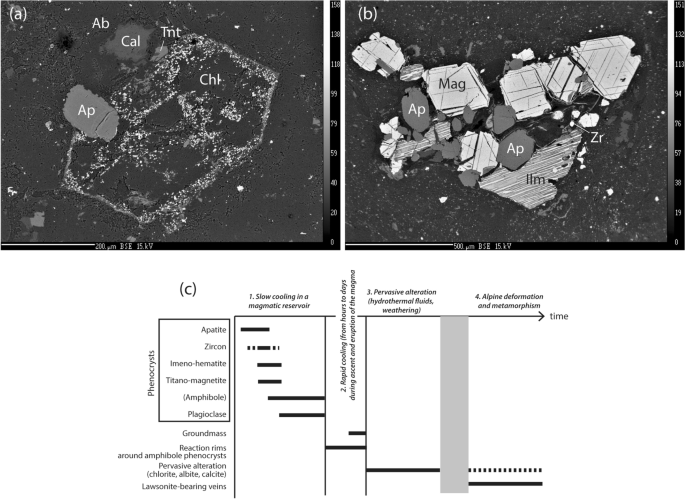
BSE images of two key textures of the Guil andesite (sample BR 15-01). a Pseudomorph of an idioblastic amphibole crystal, now replaced by a fine-grained aggregate of chlorite, and displaying two key magmatic features, namely a partial inclusion of apatite, and a narrow reaction rim enriched in minute bright crystals of magnetite. b Cluster of FeTi oxides, apatite and a minute zircon grain, illustrating the glomeroporphyritic texture of the volcanic rock. c Sequence of crystallization of the minerals in the studied andesite
-
Apatite crystals display stubby prismatic shapes (c. 150 µm), in some cases with hexagonal sections, and are either partially or totally included in the amphibole pseudomorphs, or isolated in the groundmass. Apatite crystals are generally colourless, or sometimes pale pink, as noted previously by Termier (1900), who attributed this colour to the presence of cerium. Microprobe analyses have revealed a variable amount of FeO* (up to 4.9 weight%), but without clear correlation with colour. Trace elements (Ce, Sr and Va) are negligible or below detection limit.
-
Two types of oxides are distinguished in BSE images. Some display a homogeneous composition of titano-magnetite, although they may present a few narrow (black in BSE images) exsolution lamellae. The others display abundant hematite (whitish in BSE images) lamellae in an ilmenite matrix, suggesting that the crystal was a former ilmeno-hematite.
-
Zircon is easily identified as small grains with whitish colours in BSE and a characteristic bluish fluorescence with the microprobe.

In the groundmass, very fine grained crystals (3–5 µm) of albite, Fe-oxydes, abundant titanite, and rare quartz have been identified.
The sample from the Combarine sill in the Briançon area displays a porphyritic texture, with few phenocrysts of amphibole, plagioclase, quartz and apatite. Altered plagioclase phenocrysts are frequently grouped together, and replaced by chlorite, muscovite, albite and epidote aggregates. Idioblastic phenocrysts now consisting of chlorite (with minor amounts of albite and muscovite) are thought to derive from amphibole. The fine-grained matrix is essentially made of albite, with a few oxides and quartz gains.
4.2 Geochemistry of the magmatism
The volcanic rocks from the Guil valley have been named dacite, andesite or trachy-andesite by different authors (Termier 1901; Lonchampt 1962; Feys et al. 1964; Ouazzani and Lapierre 1986; Ouazzani et al. 1986; Cannic et al. 2002). Bulk-rock chemical analyses have been made on the two samples studied (BR 15-01 and HL 15-01), which are reported in classification diagrams together with the analyses from the literature (Fig. 6). In the TAS diagram (Total Alkali–SiO2) (Le Maitre 2002), the Guil volcanics plot in the field of intermediate compositions and show variable alkali content (4 < Na2O + K2O < 8 wt%). The K2O content varies from 0.7 to 2.5% (1.2% in sample BR 15-01). Based on this diagram, the Guil volcanics can be named trachy-andesites or andesites. However, given the large amount of alteration in these rocks, and given that the alkalis are especially prone to leaching, the use of the TAS diagram is not favoured for qualifying the Guil volcanics.

a Bulk chemistry of the Guil volcanics (sample BR 15-01) and of the Combarine sill (sample HL 15-01) reported in the TAS diagram (Le Maître 2002) and in the SiO2–Zr/TiO2 plot (Winchester and Floyd 1976). All available analyses have been reported on an anhydrous basis. b REE patterns (normalized to the chondrites according to McDonough and Sun 1995) of the Guil volcanics and of the Combarine sill compared with other volcanic rocks from the Briançon area
Many different classifications have been devised for discriminating altered volcanic rocks. These classifications are based on elements considered as immobile or weakly mobile during alteration (Zr, Ti, Nb, Y), and bivariate plots have been proposed such as SiO2–Zr/TiO2 Zr/TiO2–Nb/Y, Zr/TiO2–Ga (Winchester and Floyd 1976; Floyd and Winchester 1978; Pearce et al. 1984; Pearce 1996; Hastie et al. 2007). In these diagrams, the Guil volcanics plot in the fields of andesite and dacite/rhyodacite.
Amongst the trace elements, the rare-earth elements (REE) are considered as the least mobile. REE abundances have been measured in a total of 11 samples (Ouazzani et al. 1986; Cannic et al. 2002), including the two from this study (Fig. 6c). We reported also the REE composition normalised to chondrites values (McDonough and Sun 1995) of the microdiorite sill (sample HL 15-01). All samples display similar patterns, with a slight to moderate enrichment in light REE with a mean ratio La/Sm = 2.94 (min = 2.36, max = 3.44), no Eu anomaly, or a weak one, and a slightly concave shape for the heavy REE with a mean Gd/Lu = 1.34 (min = 0.96, max = 1.72). These patterns are very similar to other calc-alkaline Permian volcanics from the Alps (e.g. Cortesogno et al. 1998; Buzzi and Gaggero 2008).
5 U–Pb geochronology
5.1 U–Pb data for the Guil andesite (sample BR 15-01)
Zircon extracted from the andesitic sample were generally euhedral, acicular to stocky in shape depending on their size. In the CL images, they show oscillatory zoning characteristic for magmatic zircon. Twenty-four analyses were performed out of 17 different grains (Additional file 5: Table S5). The U and Pb contents are fairly consistent (49–299 ppm and 7–57 ppm respectively). Their Th/U ratios are comprised between 0.2 and 0.4, values usually considered as characteristic of magmatic zircon (see Kydonakis et al. 2014 and refs therein). Plotted in a Tera-Wasserburg diagram (Fig. 7a), the data are concordant within error and allow calculating a Concordia date (as of Ludwig 1998) of 291.3 ± 2.0 Ma (MSWD = 1.7, n = 24).

a, b Tera-Wasserburg diagrams (207Pb/206Pb vs. 238U/206Pb) with the data obtained on zircon grains extracted from the Guil volcanics (sample BR 15-01) and the microdioritic sill (sample HL 15-01). c, d Tera-Wasserburg diagrams for the apatite grains from the same samples. The red discordia lines were obtained with a free regression of the data while the black discordia lines were obtained by forcing the regression to a (207Pb/206Pb)0 value of 0.855 obtained using the Stacey and Kramers Pb evolution model (1975) for an age of ca. 295 Ma
The apatite crystals were euhedral and prismatic with very homogeneous CL imaging. Thirteen crystals were analysed (Additional file 5: Table S5) and the 20 analyses are reported in a Tera-Wasserburg diagram (Fig. 7c). These data yield a narrow range of 238U/206Pb ratios (ca 5.5 to 8.5) and poorly radiogenic and consistent 207Pb/206Pb ratios (0.54–0.64). In consequence, a free regression trough these data yield a poorly constrained lower intercept date of 272 ± 14 Ma (MSWD = 4.5, (207Pb/206Pb)0 = 0.835). If we anchor the discordia to a (207Pb/206Pb)0 value of 0.855 calculated using the Stacey and Kramers (1975) Pb evolution model for an age of ca. 295 Ma, the resulting lower intercept date is 287.5 ± 2.6 Ma (MSWD = 4.5).
5.2 U–Pb data for the the Combarine microdiorite (sample HL 15-01)
Zircon grains extracted from this sample present a wide variety of shape from prismatic to rounded. They do not show evidence for internal zoning and some show the presence of cores and rims. Their uranium and Pb contents as well as their Th/U ratios are also very variable (U: 28–663 ppm; Pb: 24–361 ppm and Th/U 0.1 to 1.26 respectively; Additional file 5: Table S5). Twenty-four analyses on fifteen different grains were acquired. In a Tera-Wasserburg diagram (Fig. 7b), they plot mostly in a concordant position. They define several groups with apparent ages around 1938 Ma, 843 Ma, 633 Ma, 395 Ma, 333 Ma, while the youngest concordant grains yield a concordia date of 295.9 ± 2.6 Ma (MSWD = 0.2; n = 3).
Apatite crystals are on the contrary very similar in this sample and are mostly euhedral and prismatic with very homogeneous CL imaging. They present variable 238U/206Pb (ca. 1.1 to 7.4) and 207Pb/206Pb (ca. 0.57 to 0.82) ratios (Additional file 5: Table S5). Plotted in a Tera-Wasserburg diagram (Fig. 7d), they define a lower intercept date of 286.1 ± 7.9 Ma (MSWD = 2.1, n = 18) with a (207Pb/206Pb)0 = 0.853. This date is identical within error with the date of 288 ± 4.5 Ma (MSWD = 2) obtained if the data are anchored to a (207Pb/206Pb)0 of 0.855 calculated using the Stacey and Kramers Pb evolution model (1975).
In summary, both localities from the External Briançonnais yield Early Permian ages for the calc-alkaline magmatism in these units.
6 Discussion regarding the age of Permian magmatism in the External Briançonnais
6.1 Magmatic history
Despite pervasive alteration, it is possible to reconstruct part of the magmatic history of the Guil andesites (Fig. 5c).
-
1.
The first mineral crystallizing from the magma was apatite, followed by the FeTi oxydes (ilmeno-hematite and titano-magnetite), then the FeMg silicates (amphibole) and finally plagioclase feldspar. The phenocrysts record a first stage of the magmatic evolution, namely a slow cooling possibly in a crustal magma chamber.
-
2.
When the lava erupted to the surface, i.e. on top of the Carboniferous sediments, the matrix cooled quickly, allowing the development of a glassy matrix, now pervasively altered. However, part of the magmatic history is recorded by the fine corona of magnetite (and other microcrystalline material, now altered) surrounding the former amphibole (hornblende) crystals in contact with the melt. Such textures are reported worldwide in many intermediate and acidic lavas, especially andesites (e.g. Rutherford and Hill 1993; Rutherford and Devine 2003; Buckley et al. 2006; Plechov et al. 2008), and interpreted as recording partial breakdown reaction of hornblende due to decompression during final magma ascent.
-
3.
The andesitic rocks have been pervasively altered during a later stage of their history, when the FeMg silicates and plagioclase were replaced by low temperature minerals (calcite, albite, chlorite). This alteration may have followed the eruption of the magma, or it may be related to the Alpine metamorphic history. In the lack of ductile deformation that could provide a temporal marker, no reliable criteria have been found for assessing the age (and the eventual polyphased character) of this pervasive alteration. However, due to the large amount of water and oxygen required, we favour a subaerial weathering during Permian times.
6.2 Age of the Permian magmatism in the External Briançonnais
A precise age for Permian magmatism in the External Briançonnais is required for three main reasons. Firstly, late Palaeozoic magmatism in the Briançonnais Domain has never been dated using a robust method. A Permian age was so far solely deduced from stratigraphic/intrusive relations of the magmatic rocks with the sediments. Indeed, the magmatic rocks intrude palaeontologically characterized Carboniferous sediments (the Combarine sill case), or they overly lithologically similar sediments (Guil andesites case). Secondly, the age of the Carboniferous sediments turned out to be older than previously thought, being now considered as Namurian to Westphalien A (Brousmiche Delcambre et al. 1995). Thirdly, the oldest sediments deposited on top of the volcanics are Verrucano-type conglomerates (which contain rhyolitic clasts), grading into mature quartzites. Both lithologies are azoic, and they are by convention attributed to the uppermost Permian and the early Triassic, respectively. In summary, there is a considerable time gap (from c. 310 Ma to 250 Ma) during which the magmatism (in one or several episodes) might have taken place. Recent studies have emphasized the widespread character and long-lasting duration of the Permian magmatism in the Briançonnais domain (e.g. in the Ligurian Alps: Cortesogno et al. 1998; Buzzi and Gaggero 2008), in the Sesia-Dent Blanche nappes (Manzotti et al. 2018), in the Austroalpine nappes (e.g. Petri et al. 2017), as well as in the Southern Alps (Pohl et al. 2018).
Both radiometric ages obtained for the Guil andesite at 291.3 ± 2.0 Ma (zircon) and 287.5 ± 2.6 Ma (apatite) definitively establish an Early Permian age for the volcanism in the studied area (Fig. 7a, c). The apparent ages (ca. 1938 Ma, 843 Ma, 633 Ma, 395 Ma, 333 Ma et 295 Ma) obtained on zircon from the Combarine locality dioritic sill demonstrate the presence of several zircon populations, although the youngest date at ca. 295 Ma is compatible within error with the age obtained for the emplacement (Fig. 7b). For all the other, older, apparent ages, it appears to be reasonable to propose that they belong to xenocrysts inherited from the country rocks. A recent study of the detrital zircon populations from a Carboniferous sandstone layer cropping out near the sill (Manzotti et al. 2016) yielded ages very similar to those found in the zircon grains from that sill. Since this sill was emplaced within Carboniferous sediments, it is reasonable to think that these zircon grains were extracted from the country rocks during the magma ascent and emplacement.
Yet another information can be obtained from our new geochronological data. The U–Pb apatite age (287.5 ± 2.6 Ma) is undistinguishable within error with the age obtained on zircon (291.3 ± 2.0 Ma). The lowest closure temperature reported for apatite is around 370 °C (Cochrane et al. 2014) far below the accepted closure temperature for zircon (> 900 °C). Because the apatite and zircon ages are identical within error, this means that the U–Pb system of the apatite was not reset and that, therefore, these volcanics did not reach elevated temperatures during Alpine metamorphism.
The zircon data from the Combarine locality dioritic sill are rather complex (Fig. 7b). However, in the light of the data and their interpretation from the Guil locality andesitic lavas, we propose that the date of 288 ± 4.5 Ma obtained on apatite extracted from the Combarine sill represents the emplacement age for this sill. It has been demonstrated by Pochon et al. (2016) that magmas emplaced in sills or dykes cool down very quickly (in less than a century). Therefore, the closure temperature of the dated mineral does not count in this specific context. The three zircon grains that yielded a date of 295.9 ± 2.6 Ma compatible with the age obtained on apatite can therefore be interpreted as magmatic in origin. The new zircon and apatite ages from the Combarine sill are slightly older than those obtained previously using the Ar–Ar method on amphibole (Cannic et al. 2002).
In summary, two main conclusions are obtained from the geochronological data. Firstly, the calk-alkaline magmatism is dated at ca. 290 Ma (Early Permian). Compared to the other basement units along the same traverse (Fig. 8), these new data reinforce the conclusion that the dominant magmatism in the Briançonnais Domain is Early Permian in age, whereas the magmatism in the External Dauphinois domain is Late Carboniferous (Ballèvre et al. 2018). Secondly, the lack of resetting of the apatite ages shows that the studied part of the External Briançonnais was metamorphosed at moderate temperatures (below 370 °C) during the Alpine orogeny.

7 Discussion on metamorphism affecting Permian magmatic rocks in the External Briançonnais
Evidence for Alpine deformation and metamorphism is scanty in the studied rocks. In accordance with Tricart (1980), we noted the lack of ductile deformation in the Early Triassic sandstones (nicely preserving ripple-marks and cross-bedding), and in the underlying Guil andesites (nicely preserving the igneous textures, despite an extensive alteration). Alpine deformation in the latter is recorded by a set of veins, a few metres long and up to 20 cm thick. The presence of a fibrous mineral along the vein walls was reported by Lonchampt (1962), and was identified by R. Caby and P. Saliot as lawsonite (Saliot 1978; Saliot et al. 1980).
Detailed examination of the andesitic outcrops along the main road reveal the occurrence of two vein generations. The first generation consists of large veins, up to a few metres in length and 20 cm in thickness (Fig. 9). The dominant material in these veins is calcite and quartz, some of the veins displaying lawsonite and pumpellyite crystals (as fibers and sheaves) along their walls. Lawsonite fibers may have length up to 1 cm, and make a dense fibrous aggregate up to 2 cm thick along the vein walls. In thin section, different assemblages have been found, with various combinations of quartz, calcite, lawsonite, pumpellyite, epidote and K-feldspar. Microprobe analyses show that lawsonite is very close to ideal composition, with no Cr and negligible Fe3+ substitutions. Pumpellyite displays a moderate, and variable, amount of Fe (the ratio Fe/(Fe + Mn + Mg) varies between 0.22 and 0.41). The lawsonite-bearing veins are cut by a second generation of microveins, not thicker than a few mm, containing albite, calcite and very small crystals of barytine.

Lawsonite veins in the Guil andesites. a Field aspect of the veins, with fibrous lawsonite localized along the vein walls, or against thin slices of wall rock (andesite) preserved inside the vein, showing several stages of opening. b, c Microphotographs of the vein, both in crossed-polarized light, showing the lawsonite (Lws) needles in a quartz (Qtz) matrix
Lawsonite is a hydrous-rich mineral (about 12% weight of H2O) precipitating from the fluid in the veins. Lawsonite has not been found outside the veins, suggesting restricted fluid access in the volcanic rock adjacent to the veins. The stability field of lawsonite has been experimentally investigated at low pressure by Liou (1971). According to these experiments, growth of lawsonite in the veins require a minimum fluid P of the order of 0.3 GPa for the assemblage lawsonite + quartz (Fig. 10). Using fluid inclusions, Saliot (1978) and Saliot et al. (1980) suggested temperature values of the order of 320 °C, and deduced a fluid pressure of 0.4 GPa.

Estimated P–T conditions for the lawsonite-bearing veins in the Guil valley (Saliot et al. 1980), compared to other estimates for external part of the Briançonais Zone, namely the Clarée valley (Lanari et al. 2012) and Plan de Phazy (Lanari et al. 2014). The stability field of lawsonite + quartz + fluid is shown in blue, according to the experimental data of Liou (1971). The lowest closure T of the U–Pb system in apatite (c. 370 °C) is also indicated (Cochrane et al. 2014)
The lawsonite veins from the Guil valley do not represent an isolated occurrence of this mineral in the Zone Houillère. Indeed, other occurrences of lawsonite and/or pumpellyite have been reported in microdiorites from different localities (Fabre 1961; Guitard and Saliot 1971; Piantone 1980; Michard et al. 2004) (Fig. 11). In the Carboniferous metasediments from the Zone Houillère in the Clarée valley, the P–T conditions of Alpine metamorphism have been estimated at 5.9 ± 1.7 kbar, 275 ± 23 °C, based on Raman Spectrometry of Carbonaceous Material and chlorite-phengite quartz assemblages (Lanari et al. 2012). In the Clarée valley, lawsonite has been reported in metadiorites intrusives within the Carboniferous metasediments (Guitard and Saliot 1971; Piantone 1980). Closer to our study area, chlorite-phengite assemblages in the deformed rocks (Permian metasediments according to Kerckhove and Piboule 1999 and Kerckhove et al. 2005; granitic gneisses according to Lanari et al. 2014) from Plan de Phazy have provided estimates at 8.1 ± 2 kbar, 270 ± 50 °C (Lanari et al. 2014). At these two localities, the temperature values are not significantly different from those proposed in this study, although pressure values are much higher than our minimum estimate (0.4 GPa). Assuming a lithostatic gradient, the minimum pressure estimates indicate that the depth reached by the Zone Houillère during the early stages of the Alpine orogeny should be at least at around 12 km.

Simplified metamorphic map of the SW Alps. Colours refer to both metamorphic grade (in terms of metamorphic facies), and ages. This map is based on Bearth (1962), Bocquet (1971), Bousquet et al. (2004), Michard et al. (2004), Bousquet et al. (2008), Beltrando et al. (2010), Groppo et al. (2019), and our own observations. The distribution of lawsonite (red lozenges) is only shown in the External Briançonnais. Further east, lawsonite becomes widespread in the meta-ophiolites and meta-sediments of the Piemonte-Liguria Ocean (e.g. Caron 1974; Lefeuvre et al. 2020; Vitale Brovarone et al. 2020). Key references for the age of the peak-pressure metamorphism are found in Manzotti et al. (2014) and refs therein for the Sesia-Zone; Rubatto et al. (2008) for the Lanzo peridotites; Monié and Phillipot (1989), Rubatto and Hermann (2003), Rubatto and Angiboust (2015) and Garber et al. (2020) for the Viso; Agard et al. (2002) for the Queyras; and Rubatto and Hermann (2001), Gauthiez-Putallaz et al. (2016) and Chen et al. (2017) for the Brossasco-Isasca Unit. The two studied samples from the Zone Houillère (Guillestre and Briançon) belong to units displaying low-grade parageneses (lawsonite-albite), while their equivalents in the Pinerolo Unit are characterised by garnet-blueschist facies assemblages. Despite identity of the pre-Alpine history i.e. Carboniferous sedimentation (Manzotti et al. 2016) and early Permian magmatism (this study), their fate during the Alpine orogeny is very different
8 From detached cover nappes to subducted basement slices, a discussion at a larger scale
Along a traverse across the Western Alps, the different tectonic units whose Mesozoic sediments are known to be derived from the Briançonnais Domain occur in a complexly refolded stack of detached cover nappes, and it is suspected that their pre-Mesozoic substrate may occur in the form of subducted basement slices, such as, for example, the different units of the Dora-Maira Internal Massif that have been attributed to the Briançonnais Domain by some authors (e.g. Vialon 1966; Figs. 1 and 11). Detached cover nappes and their suspected former basement outcrop in two different areas. The Briançonnais s.str. at the western end of the section forms an arcuate, elongated zone mainly made up by detached cover nappes, and constitutes the ‘classic’ (native) area for defining the Briançonnais Zone of the French authors (Termier 1903). At the eastern end of the section, basement slices stacked and folded together build the Dora-Maira Massif (Vialon 1966; Sandrone et al. 1993). As emphasized by Goguel (1950), cover detachment implies that the underlying basement has been simultaneously dragged down into the convergent zone, a process for which the concept of ‘subductions profondes’ was already used by Debelmas and Gidon (1958). What was the basement of the detached cover sequences, and where is it now? The obvious candidates are the tectonic slices now constituting the Dora-Maira Massif (Vialon 1966; Michard 1977).
8.1 Detached cover nappes
The sedimentary history of the Mesozoic sequences allows comparing their paleotectonic record within the Briançonnais Domain passive margin and deduce their palaeogeographic organization. Several types of sequences have been distinguished (e.g. Debelmas 1955; Gidon 1962; Michard, 1967; Michard and Henry 1988; Gidon et al. 1994) (Fig. 1).
8.1.1 Sedimentary sequences of the External Briançonnais
A first type of sedimentary successions is found in the External Briançonnais., i.e. the ‘classical’ Briançonnais. The successions described in the eastern part of the Guil valley (Fig. 2) are rather typical, although a great deal of variation is observed in detail. The most characteristic elements of these successions are the Early Triassic quartzites, followed by Middle to Upper Triassic carbonates, on top of which disconformably rest Middle and Late Jurassic syn- and post-rift sediments. Typically, Lower Jurassic sediments are lacking. This is attributed to a period a subaerial erosion (karstification) during rifting. The sedimentary successions of the External Briançonnais are either detached from their Palaeozoic basement, or rest upon the Carboniferous (and minor Permian) of the Zone Houillère (e.g. Lower Unit of the Guil Valley; Cerces and Tabor area north of Briançon). Polycyclic rocks are described east of Modane and further north (Sapey gneisses: Ellenberger 1958; Détraz and Loubat 1984), but their relationships to the Zone Houillère and the Mesozoic cover remains uncertain.
8.1.2 Sedimentary successions of the Internal Briançonnais
A second type of Mesozoic successions is kown in the Internal Briançonnais and is characterized by the lack of Triassic carbonates below the Jurassic-Cretaceous sediments. The latter typically rest upon the Triassic quartzites, or even upon the Palaeozoic. Such successions may be referred as the Acceglio-type Internal Briançonnais (Debelmas and Lemoine 1957). They are best developed in the Roure (Le Guernic 1967) and Acceglio (Michard 1959; Lemoine 1960; Lefèvre and Michard 1976) units (Fig. 1). Where preserved, the Palaeozoic rocks are in most cases made of porphyritic volcanics and associated sediments, attributed to the Permian. Occurrences of polycyclic basement rocks are exceptional but found in the Acceglio Unit (Grangie Sagneres: Lefèvre and Michard 1976). Further north, polycyclic rocks are described from the core of the Ambin Massif (Gay 1972; Monié 1990; Ganne et al. 2003), where they are separated from the Mesozoic sediments by a ESE or E-vergent D2 shear zone (Ganne et al. 2005).
A third type of sedimentary succession is also part of the Internal Briançonnais and has been refered under various names such as the ‘série (or zone) du Gondran’ or ‘Pre-Piemontais’ or ‘External Piemontese sequence’. We will use the term “Gondran-type Internal Briançonnais” for these type three units that are aligned along the eastern (internal) boundary of the units of the Briançonnais s.str. and back thrusted over units that are ascribed to the Piemonte-Liguria oceanic domain (Fig. 2). These successions are characterized by a thick Norian dolomite formation, followed by Rhaetian-Hettangian fossiliferous limestones (with in situ corals), and then overlain by calcschists in stratigraphic contact, including numerous layers of dolomitic microbreccias. From North to South, this type of succession has been described in the following places (all of them are reported in Fig. 1): Grand Argentier-Mélezet (Caby 1964, 1996), Chaberton (Franchi 1911; Mégard-Galli 1974), Gondran (Lemoine 1961b, 1971), Rochebrune (Mégard-Galli 1974; Dumont 1984), and Roche des Clots (Lemoine et al. 1978; Debelmas 1983). Similar sequences are also reported from units located further East, lying as klippen on the metasediments and associated ophiolitic slices attributed to the Piemonte-Liguria, namely the Gran Roc (Franchi 1929; Caron 1971; Mégard-Galli and Caron 1972) and the Péouvou (Fig. 1). No Palaeozoic basement has been observed at the base of these successions, which are detached along an evaporitic layer located below the Norian dolomites.
8.1.3 Sedimentary successions of the Dora-Maira Massif
Along the northern margin of the Dora-Maira Massif, Mesozoic sediments are found in the Susa valley (Franchi 1898; Marthaler et al. 1986; Fudral 1998), where they are intensely deformed and metamorphosed. However, a few quartzites and more frequent dolomites have been attributed to the Triassic following the discovery of crinoid columnals in the latter (Franchi 1898). The marbles and calcschists contain Cretaceous microfossils (Marthaler et al. 1986). It is difficult to ascribe this poorly-defined succession to one of the three types distinguished above, although one might be tempted to compare it to the ‘classical’ Briançonnais of Vanoise (Ellenberger 1958).
Along the southeastern margin of the Dora-Maira Massif, tectonic slices made up of dominantly Mesozoic metasediments with occasional occurrences of Permian sediments are thrusted onto the basement units of the Dora-Maira Massif. We refer to these successions as “Valle Maira-type Briançonnais”. These slices largely outcrop in the Grana, Maira and Varaita valleys. The Mesozoic sucessions comprise, besides occasionally preserved Middle Triassic carbonates, fossiliferous Upper Triassic carbonates, followed by a thick formation preserving Liassic fossils (belemnites, ammonites: Franchi 1898; Sturani 1961; Ellenberger et al. 1964; Michard 1967). The latter finally grade into dolomite-bearing microbbreccias (Franceschetti 1961). This carbonate succession is stratigraphically overlain by Schistes lustrés type sediments (e.g. Franchi 1898; Sturani 1961; Ellenberger et al. 1964; Michard 1967, Michard and Schumacher 1973, Lemoine 2003). This entire Mesozoic succession has close similarities with the Gondran-type Internal Briançonnais discussed above (e.g. Lemoine and Michard 1963; Dumont 1984). However, this Valle Maira type Briançonnais occurs in a very different present-day tectonic position, in that it directly overlies the basement slices of the Dora Maira Massif (Fig. 2). The metamorphic grade of these cover units is poorly known but it is likely that the Mesozoic sediments underwent a blueschist-facies event (Michard 1967). The Palaeozoic basement originally underlying these successions is unknown. With respect to the underlying Dronero-Sampeyre Unit, the tectonically highest unit of the southern Dora Maira Massif, these Mesozoic successions are at least parautochtonuous, if not allochthonous. Any statement about the amount of tectonic displacement between Valle Maira-type Briançonnais and underlying Dronero-Sampeyre Unit is speculative given the lack of precise petrological data allowing a comparison of their metamorphic grade.
8.2 Subducted basement slices of the Dora Maira Massif
The Dora-Maira Massif is made of several stacked units, which may be distinguished on the basis of (i) their constituent lithologies, (ii) their polycylic or monocyclic metamorphic history, (iii) the existing differences in peak P (assuming that these represent differences in depths), and (iv) the occurrence of thin slices of oceanic material sandwiched in between the volumetrically dominating continentally-derived material. Earlier mapping by the Italian geologists at the end of the nineteenth century was an essential basis for the remarkable synthesis of Vialon (1966). However, there is still ample space for structural-petrological mapping in the Dora-Maira Massif, although detailed work has been performed recently in its southern part (e.g. Henry et al. 1993; Groppo et al. 2019). Still much remains to be done in the northern part (valle Po, Pellice and Chisone) (e.g. Cadoppi et al. 2016). A tentative summary of our knowledge is shown on Fig. 1, which should be considered as a preliminary attempt to identify different tectonic units, briefly described below.
8.2.1 Lower Pinerolo garnet blueschist facies Unit
The lowermost Pinerolo Unit essentially consists of graphite-rich metasediments (conglomerates, sandstones and siltstones) with interbedded graphite layers, interpreted as former coal levels (Franchi and Novarese 1895; Novarese 1895, 1898, 1905). Because of this lithological association, the protoliths of the Pinerolo metasediments are considered Carboniferous in age since Novarese (1895, 1898). This age is now further bracketed by two recent studies. Firstly, detrital zircons in the Pinerolo metasediments are characterized by the occurrence of a large, and most recent, zircon population with an age of c. 330 Ma (Manzotti et al. 2016). Secondly, the metadiorites observed inside the Pinerolo Unit are thought to derive from dioritic bodies intruding the sediments, inducing contact metamorphism (with presumed chiastolite relics: Novarese 1895) and dated at 290 Ma (Bussy and Cadoppi 1996). Note that this age is similar to the one of the diorite sills and Guil volcanics in the Briançonnais s.str., intruding the Zone Houillère or erupted on top of the Carboniferous sediments and dated in this study.
In summary, there is a striking similarity—if not identity—between the late Palaeozoic history of the Pinerolo Unit and that of the “Zone Houillère”. It is therefore tempting to link the two as belonging to the same part of the Briançonnais passive margin in a paleogeographical sense. However, the geometry of this link in the present-day profile across the Western Alps is unkown. It has to be emphasized that the Mesozoic sedimentary cover of the Pinerolo Unit is unknown, and therefore not much can be said that would not be speculative. On the other hand, it is reasonable to assume that there must have been a physical, continuous link between Zone Houillère and the Pinerolo Unit before the Alpine orogeny (e.g. Michard 1977).
A closer look to this problem should consider the following observations. Firstly, in the Chisone and Pellice vallleys (Fig. 1), where the Pinerolo Unit is extensively outcropping, no evidence for a Mesozoic cover has ever been reported. Secondly, in the northern side of the Po valley (Fig. 1), the intensely deformed and metamorphosed quartzites from Monte Bracco may represent Early Triassic sediments. Some dolomite-bearing successions close to Sanfront, on the southern side of the Po valley, have also been attributed to the Middle-Upper Triassic (Michard 1977, p. 189). However, their relationships with the graphitic metaconglomerates of the Pinerolo Unit need yet to be clarified. As a general statement, given the identity between the Zone Houillère and the Pinerolo lithologies, we propose that the Mesozoic cover of the Pinerolo Unit was detached from the Carboniferous sediments at an early stage of the convergence history, and is now part of the cover nappe stack in the units of the Briançonnais Domain (Figs. 1 and 2).
8.2.2 Middle eclogite facies units
Stacked units made of a polycyclic basement (i.e. with relics of a pre-Alpine metamorphism) are found on top of the Pinerolo Unit and constitute the middle unit of the Dora Maira Massif. They suffered eclogite-facies metamorphism during the Alpine orogeny. This is best documented by the coesite-bearing Brossasco-Isasca Unit, and is potentially also displayed by the eclogite-bearing units found in most of the Dora-Maira Massif (the Rocca Solei Unit in the Varaita valley: Groppo et al. 2019; the eclogite-bearing gneisses in Pellice valley: Pognante and Sandrone 1989; Scaillet 1996).
Thin slices of marbles and calcschists have been mapped inside the micaschists and gneisses of these polycyclic units (Vialon 1966; Cadoppi et al. 2016). The protolith age of the marbles and calcschists and their structural relationships with the basement is difficult to ascertain. In a few cases, relict pre-Alpine assemblages have been described (e.g. marbles from the Brossasco-Isasaca Unit: Castelli et al. 2007; Germanasca valley: Cadoppi et al. 2016), in which case these lithologies do not derive from Mesozoic sediments. If they represent Mesozoic sediments, they could mark internal tectonic boundaries within the polycyclic units, and may have been isoclinally folded together with the basement during the Alpine orogeny. We consider that, in most cases, the original Mesozoic cover of these polycyclic middle units of the Dora Maira Unit (e.g. Brossasco-Isasca, Rocca Solei: e.g. Groppo et al. 2019 and refs therein) is lacking. Hence, we assume that the Mesozoic was probably detached from its former basement at an early stage of the Alpine convergence, before peak P was achieved.
8.2.3 Upper Dronero-Sampeyre garnet blueschist facies unit
The uppermost slice of the Dora-Maira Massif, i.e. the Dronero-Sampeyre Unit forming the base of the Valle Maira type Internal Briançonnais, is essentially made of quartz-chlorite-ankerite schists, phengite-rich quartzites containing quartz pebbles and grading into quartzites, and augen-gneisses. All these lithologies are of presumed Permian age (Chopin et al. 1991). Polycyclic rocks (with relict pre-Alpine garnet: Groppo et al. 2019) only make up a minor part of the Dronero-Sampeyre Unit. The latter is separated from the underlying eclogite-facies continental units by a thin layer of calcschists, greenschists and serpentinites derived from the Piemonte-Liguria Ocean (Vialon 1966; Michard 1967) (Fig. 1). The metamorphic history of the Dronero-Sampeyre Unit has not been studied in as much detail as that of the other units of the southern Dora-Maira Massif. Observed mineral parageneses record a blueschist-facies metamorphism during Alpine orogeny, with P–T estimations ranging from c. 1.0–1.2 GPa, 450–500 °C (Chopin et al. 1991) to 1.7–1.8 GPa 450–470 °C (Groppo et al. 2019). A widespread greenschist-facies overprint is present in this unit.
8.3 From detachment of the cover sediments to stacking of basement slices
8.3.1 Crustal structure of the passive palaeomargin
Figure 12 shows an attempt at reconstructing the crustal structure of the passive margin of the Briançonnais Domain during the Late Jurassic. At this scale, the Mesozoic sediments represent only a very small fraction of the crust (the uppermost 500 to 1000 m), whose thickness has to be exaggerated on the drawing for the sake of clarity. Below the Mesozoic sediments, the Permian volcanics and sediments and the Carboniferous coal-bearing conglomerates and sandstones may attain a few kilometres in thickness. However, the bulk of the crust is made by the polycyclic (Variscan) basement. The latter is divided into an upper part, rich in Permian intrusives, that potentially preserves relics of the pre-Permian (Variscan) metamorphic history, and a lower part, dominated by the Permian partially-melted rocks and the associated gabbroic intrusives accreted close to or along the Moho surface.

Proposed correlations between detached cover nappes (External and Internal Briançonnais) and subducted basement slices (Dora-Maira Massif). See text for further explanations
The reconstruction shown in Fig. 12 integrates data and discussions known since a long time. The key position of the Gondran-type successions, with their abundant breccias recording the Early Jurassic extension, has been emphasized by previous authors (e.g. Lemoine 1961b, 1967; Lemoine et al. 1986; Lemoine and Trümpy 1987), and adopted by most recent works (e.g. Haupert et al. 2016; Ribes et al. 2019). This structure can be extended further north in the Valais area where similar successions are still in primary contact with the bounding normal faults or make up the bulk of some Prealpine nappes (Nappe de la Brèche: see Pantet et al. 2020 and refs therein). The diversity of stratigraphic successions across the Briançonnais Domain may be used not only for understanding the Jurassic structure of the palaeomargin, but has major consequences for its mechanical behaviour during the Alpine orogeny. Three of these are briefly discussed now.
Firstly, the occurrence of evaporitic layers in the Triassic allows detachment of the Mesozoic cover from the Palaeozoic substrate. However, the evaporitic layers are not evenly distributed. They play a major mechanical role in the External Briançonnais (Peyre-Haute, Fonta-Sancte and other nappes), and in the innermost part of the Internal Briançonnais (Gondran and Grana-Maira successions). By contrast, the Triassic carbonates and evaporites have been eroded in the Acceglio-type successions (Fig. 12). Therefore, the evaporitic layers were no more present at the time of the Alpine shortening in these successions. This explains why Jurassic sediments are still attached to the underlying Early Triassic quartzites and the Permian volcanics and sediments (see red arrows on Fig. 12). A remote but significant consequence of this behaviour is the lack of Acceglio-type successions in the basal slices of the Parpaillon Nappe. These slices are mostly made of successions similar to the ones of the External Briançonnais, with one notable exception that has an Acceglio-type affinity, namely the Roche Chevalière slice (Kerckhove 1969).
Secondly, other potential detachement layers are present inside (along the coal-bearing layers) or at the base of the Carboniferous sediments (Fig. 12). It is questionable if the Carboniferous successions of the present-day Zone Houillère and Pinerolo units were deposited in the very same basin. However, we note that the detrital zircon record in both units is similar (Manzotti et al. 2016), implying at least similar sources. Other Carboniferous successions in the Briançonnais Domain display different patterns of detrital zircons, and did therefore belong to distinct basins (see Manzotti et al. 2015 for the Money window in the Gran Paradiso massif). Further work on detrital geochronology is needed in order to better constrain the links between the Carboniferous basins and their source area in the future Alpine belt.
Thirdly, the rifting associated with the opening of the Piemonte-Liguria Ocean was most probably asymmetric (Lemoine et al. 1987), the Austroalpine forming a lower plate margin and the Briançonnais an upper plate margin. As a consequence, the Briançonnais lower crust was ‘extracted’ from the corresponding margin, and will be located in an upper plate position during the Alpine convergence. This process is difficult to substantiate along the Embrun-Pinerolo traverse discussed in this study, because the frontal Austroalpine units are no more observed today in the Western Alps. Field studies in other areas (e.g. Froitzheim and Eberli 1990; Mohn et al. 2010) and numerical models (e.g. Petri et al. 2019) have documented the importance of the lithological and tectonic heterogeneities at crustal scale in shaping the crust during extension. According to such studies, it is therefore possible that the different basement units from the Briançonnais Domain (and especially the Dora-Maira Massif) may represent extensional allochthons, but field evidence in favour of this hypothesis is still lacking in the studied traverse.
8.3.2 Main steps of the tectonic evolution
The present-day geometry of the Alpine nappe stack (Fig. 1) shows that most of the Mesozoic covers were detached from their corresponding basement along one or more decollement layers, either along one of the two Triassic evaporite layers, or along the interface below the Early Triassic quartzites. In a few cases, part of the Palaeozoic basement is still attached to the Mesozoic sequence, like in the Zone Houillère or in some of the innermost units of the Briançonnnais Zone (Roure, Acceglio, where the Permian volcanics are seen below their Mesozoic cover). However, part of the Carboniferous sedimentary sequence and associated magmatic rocks (Pinerolo) and the bulk of the polycyclic basement has been dragged into the Alpine subduction zone, where it was affected by varying grades of metamorphism (from garnet-blueschist to coesite-eclogite facies). It is a remarkable fact (and this is true at the scale of the Western Alps) that the Briançonnais lower crust is not found at the surface today anywhere, to the contrary of the Adriatic lower crust, which is often found both in the Sesia-Dent Blanche nappes (see e.g. Manzotti et al. 2014 for a summary) and in the Southern Alps (Ivrea Zone). One possible interpretation of this observation is that the Briançonnais lower crust is now stacked at depth, below the high-pressure units, because it was detached from its corresponding upper crust during the Alpine orogeny. Alternatively, the rifting asymmetry may have played a major role in this decoupling between the upper and lower crust during the Jurassic extension.
The close link between the Zone Houillère and the Pinerolo Unit before Alpine orogeny, and their distinct fate during the Alpine evolution, may be summarized in the schematic kinematic model of Fig. 13). The main steps are discussed in the following.

Key steps in the history of the studied samples. See text for detailed explanations
During the Late Carboniferous (Fig. 13a), deposition of the fluviatile–lacustrine sediments took place in a narrow, elongated basin controlled by the sinistral displacement along the East-Variscan Shear Zone (Ballèvre et al. 2018). U–Pb geochronology of detrital zircon in samples from Briançon and Pinerolo yields very similar ages, suggesting a source area essentially made by Early Carboniferous granitoids, possibly located in the External Massifs (Belledonne, Grandes Rousses, Pelvoux) or in the subducted basement on top of which the Sub-Briançonnais sequences were deposited (Manzotti et al. 2016).
Based on the similar ages obtained for the calc-alkaline magmatism in the Zone Houillère (this study) and the Pinerolo Unit (Bussy and Cadoppi 1996), a magmatic episode took place during the Early Permian (Fig. 13b). This is characterized by dioritic intrusions at depth (Pinerolo) and microdioritic dykes and sills in the Zone Houillère, with coeval volcanics (Combarine and Guil, respectively, analysed in this study). This calcalkaline magmatism is similar to the one observed in other localities from the Briançonnais Domain, pointing to a common geodynamic setting. The latter is characterized by an extensional to transtensive setting (e.g. Pohl et al. 2018), allowing partial melting of the upper mantle during decompression. The resulting basaltic magmas crystallized at depths in the lower crust, where they may have been contaminated by partially molten crust. One should emphasize that this lower crust is not seen in any of the presently outcropping units belonging to the Briançonnais Domain, a point that will deserve further comments during future studies.
During the Late Triassic and Early Jurassic (Fig. 13c), crustal thinning took place. Depending on the location, different types of sedimentary successions were deposited on top of the Palaeozoic basement (e.g. Lemoine et al. 1986). From West to East, the External Briançonnais successions record uplift and karstification during the Liassic. Erosion of the Triassic carbonates was achieved in the Acceglio-type Internal Briançonnais units (e.g. Acceglio and Roure units), interpreted as a rift shoulder. In other areas of the Internal Briançonnais, at the foot of major normal faults, the sequences of the Gondran-type and Valle Maira-type Internal Briançonnais were deposited during the Liassic, recording the erosion of the more external Briançonnais by a thick succession of microbreccias (Lemoine 1961b, 1967; Lemoine et al. 1986; Decarlis et al. 2017).
During the Middle Jurassic (Fig. 13d), the continental crust broke apart, giving birth to the Piemonte-Liguria Ocean (Lagabrielle and Cannat 1990; McCarthy et al. 2020). This is characterized by extensive areas where the peridotite mantle rocks were exhumed at the sea floor, with the development of ‘oceanic core complexes’ (Chenaillet: Manatschal et al. 2011; Lafay et al. 2017; Queyras: Lagabrielle et al. 2015; Viso: Balestro et al. 2015). The break-up unconformity is recorded in the thinned continental crust of the Briançonnais Domain by the onset of a new cycle of marine sedimentation, with a thin veneer of Jurassic sediments eventually capping the Palaeozoic basement in those areas where the Triassic had been eroded (Acceglio). Crustal thinning eventually led to the birth of very thin slices of upper crust, detached from their corresponding lower crust, and making up the most distal part of the Briançonnais palaeomargin (i.e. extensional allochthons) (Fig. 13d). Because the polycyclic units of the Dora-Maira Massif are only made of upper crustal material, and because their thickness is quite small (of the order of 1 km), which is difficult to justify taking into account the ductile Alpine deformation only, they may derive from such extensional allochthons.
Plate convergence begun in the Upper Cretaceous, as recorded by the history of the Sesia-Dent Blanche nappes (Manzotti et al. 2014 and refs. therein), and, in the studied traverse, by the deposition of the late Cretaceous flysch sequences (‘Helminthoid Flysch’ of the Parpaillon Nappe: Kerckhove 1969; Kerckhove et al. 2005). The Briançonnais crust was involved in the subduction process much later than the Sesia-Dent Blanche nappes. Indeed, sediments of Middle Eocene age (‘Flysch noir’) are found in the external part of the Briançonnais. The sedimentation ended with olistostromic, chaotic, deposits, micropalaeontologically dated from the early Bartonian (40 ± 1 Ma) (Barféty et al. 1992). This is slightly older than the ages derived from the ultra-high pressure rocks from the Brossasco-Isasca Unit (Rubatto and Hermann 2001; Gauthiez-Putallaz et al. 2016; Chen et al. 2017).
Most of the units that have experienced the UHP/HP metamorphism have lost most, if not all, of their Mesozoic cover. In our view the case of the Pinerolo Unit is of prime importance. Assuming that it was initially part of the very same basin of the Zone Houillère, this observation indicates that part of Mesozoic cover was possibly detached from its basement, and accreted at the front of the propagating orogenic wedge. Another, more internal, part of the Carboniferous basin (i.e. the Pinerolo Unit) was subducted to greater depths, where it experienced HP metamorphism. Lawsonite-bearing veins in the studied volcanics indicate burial of the Zone Houillère to a minimum depth of the order of 12 km, possibly up to 20 km. This burial cannot be solely due to the stacking of detached covers of Briançonnais origin, because this would require a very large margin given the thickness of the Briançonnais cover which does not exceed 0.5 to 1 km. Therefore, burial of the Zone Houillère should have been achieved below accreted oceanic material, either the accretionary prism represented by the Queyras Unit, and/or the frontal part of the overlying (i.e. upper plate) oceanic lithosphere (Fig. 13e). Both solutions are compatible with the present-day geometry of the Alpine belt in this traverse. The contact between the accretionary wedge of the Queyras oceanic units and the Gondran-type Briançonnais is presently dipping to the East (the oceanic units are structurally below the Briançonnais because of the backthrusting) (Figs. 1, 2), but was certainly dipping to the West prior to backfolding, i.e. during high-pressure metamorphism. Moreover, a preserved unit of oceanic material belonging to the upper plate (i.e. unmetamorphosed, see Fig. 11) is preserved on top of the nappe stack (the Chenaillet Unit), thanks to its preservation in a late, post-nappe, graben due to brittle, orogen-parallel, extension (Tricart and Sue 2006).
Shortly after the peak pressures of metamorphism were reached in the more internal units, continuing convergence led to the stacking of crustal slices (Fig. 13f), detached from the downgoing slab, and now making up the bulk of the Dora-Maira Massif. We follow Schmid et al. (2004, 2017) in considering that the dome-shaped Dora-Maira Massif results from the indentation of the orogenic wedge by the westward displacement of the Ivrea mantle, and in connecting the frontal Basal Briançonnais Thrust with the thrust at the base of the Ivrea Geophysical Body (see Scarponi et al. 2020 and refs therein), i.e. the rigid Adriatic mantle indenting the Alpine orogenic wedge.
9 Conclusions
The conclusions of this work are twofold.
-
1.
The Guil andesites are porphyritic rocks providing similar zircon (291.3 ± 2.0 Ma) and apatite (287.5 ± 2.6 Ma) U/Pb ages. The Combarine sill, an intrusion into Carboniferous sediments, has provided slightly older U/Pb zircon ages (295.9 ± 2.6 Ma—based on a small number of grains) and similar U/Pb apatite ages (288.0 ± 4.5 Ma) than the Combarine sill. These results indicate an Early Permian age for the calc-alkaline magmatism in the area of the Briançonnais s.str., consistent with observations in other and more internal Briançonnais-derived units in the Western Alps. The new ages also support the distinction between the essentially Carboniferous age of the magmatism in the Helvetic domain, as opposed to the dominantly Permian age of the magmatism in the Penninic domain (Ballèvre et al. 2018). In addition, the improved timing of the late Palaeozoic history of the Zone Houillère reinforces its link with the more internal and metamorphic Pinerolo Unit that is part of the Dora-Maira Massif.
-
2.
The close identity between the almost unmetamorphosed Zone Houillère and the blueschist-facies Pinerolo Unit prompted a re-examination of the potential relations between detached Mesozoic covers and subducted basement slices in the Briançonnais Domain. We favour a model where (i) most of the Mesozoic covers were detached from their Palaeozoic basement during the early stages of the Alpine orogeny, (ii) part of the Carboniferous basin was accreted to the frontal part of the orogen (Zone Houillère), while deeper or more internal parts were dragged down to blueschist-facies depths (Pinerolo Unit), and (iii) the lower crust of the polycylic basement has been detached during the Jurassic extension from its corresponding upper crust, and possibly accreted in the lower part of the thickened crust during the Late Eocene-early Oligocene shortening.
Availability of data and materials
All geochemical and geochronological data produced for this paper are available in Additional files.
References
Agard, P., Monié, P., Jolivet, L., & Goffé, B. (2002). Exhumation of the Schistes Lustrés complex: In situ laser probe 40Ar/39Ar constraints and implications for the Western Alps. Journal of Metamorphic Geology, 20, 599–618.
Balestro, G., Festa, A., Dilek, Y., & Tartarotti, P. (2015). Pre-Alpine extensional tectonics of a peridotite-localized oceanic core complex in the Late Jurassic, high-pressure Monviso ophiolite (Western Alps). Episodes, 38, 266–282.
Ballèvre, M., Manzotti, P., & Dal Piaz, G. V. (2018). Pre-Alpine (Variscan) Inheritance: A key for the location of the future Valaisan basin (Western Alps). Tectonics. https://doi.org/10.1002/2017TC004633.
Ballouard, C., Boulvais, P., Poujol, M., Gapais, D., Yamato, P., Tartèse, R., et al. (2015). Tectonic record, magmatic history and hydrothermal alteration in the Hercynian Guérande leucogranite, Armorican Massif, France. Lithos, 220–223, 1–22.
Barféty, J. C., Lemoine, M., Mercier, D., et al. (1996). Carte géol. France (1/50000), feuille Briançon (823). Orléans: BRGM. Notice explicative par Barféty, J. C., Lemoine, M., de Graciansky, P. C., et al. (1995), 180 p.
Barféty, J.-C., Tricart, P., & Jeudy de Grissac, C. (1992). La quatrième-écaille près de Biançon (Alpes françaises): un olistostrome précurseur de l’orogenèse pennique éocène. Comptes-Rendus de l’Académie des Sciences de Paris, IIA-314, 71–76.
Bearth, P. (1962). Versuch einer Gliederung alpinmetamorpher Serien der Westalpen. Schweizerische Mineralogische Petrographische Mitteilungen, 42, 127–138.
Beltrando, M., Compagnoni, R., & Lombardo, B. (2010). (Ultra-) High-pressure metamorphism and orogenesis: An alpine perspective. Gondwana Research, 18, 147–166.
Bertok, C., Martire, L., Perotti, E., d’Atri, A., & Piana, F. (2012). Kilometre-scale palaeoescarpements as evidence for Cretaceous synsedimentary tectonics in the External Briançonnais Domain (Ligurian Alps, Italy). Sedimentary Geology, 251–252, 58–75.
Bigi, G., Castellarin, A., Coli, M., Dal Piaz, G. V., Sartori, R., Scandone, P., et al. (1990). Structural model of Italy, sheet 1, C.N.R.. Firenze: Progetto Finalizzato Geodinamica, Litografia SELCA.
Blanchet, F. (1934). Etude géologique des montagnes d’Escreins (Hautes-Alpes et Basses-Alpes) (p. 184). Grenoble: Allier Père et Fils Imprimeurs.
Bocquet, J. (1971). Cartes de répartition de quelques minéraux du métamorphisme alpin dans les Alpes franco-italiennes. Eclogae Geologicae Helvetiae, 64, 71–103.
Bousquet, R., Engi, M., Gosso, G., Oberhänsli, R., Berger, A., Spalla, M. I., et al. (2004). Explanatory notes to the map: Metamorphic structure of the Alps transition from the Western to the Central Alps. Mitteilungen der Österreichische Mineralogische Gesellschaft, 149, 145–156.
Bousquet, R., Oberhänsli, R., Goffé, B., Wiederkehr, M., Koller, F., Schmid, S. M., et al. (2008). Metamorphism of metasediments at the scale of an orogen: A key to the Tertiary geodynamic volution of the Alps. In S. Siegesmund, B. Fügenschuh, & N. Froitzheim (Eds.), Tectonic aspects of tha Alpine-Dinaride-Carpathians System (Vol. 298, pp. 393–411)., Geological Society of London Special Publication London: Geological Society.
Bousquet, R., Oberhänsli, R., Schmid, S.M., Berger, A., Wiederkehr, M., Robert, C., Möller, A., Rosenberg, C., Zeilinger, G., Molli, G., & Koller, F. (2012). Metamorphic framework of the Alps. Commission for the geological map of the world; subcommission for magmatic and metamorphic maps. Paris: IUGS and IUGG. Retrieved from http://www.ccgm.org.
Brousmiche Delcambre, C., Mercier, D., & Coquel, R. (1995). Implications stratigraphiques de la révision de la flore carbonifère au Sud de Briançon. Comptes-Rendus de l’Académie des Sciences de Paris, IIA-320, 335–340.
Buckley, V. J. E., Sparks, R. S. J., & Wood, B. J. (2006). Hornblende dehydration reaction during magma ascent at Soufrière Hills Volcano, Montserrat. Contributions to Mineralogy and Petrology, 151, 121–140.
Bussy, F., & Cadoppi, P. (1996). U-Pb zircon dating of granitoids from the Dora-Maira massif (western Italian Alps). Schweizerische Mineralogische und Petrographische Mitteilungen, 76, 217–233.
Buzzi, L., & Gaggero, L. (2008). Petrogenesis of post-orogenic Lower Permian andesites in southern Europe: Insights into the collapse of the Variscan range. Geodinamica Acta, 21, 273–290.
Caby, R. (1964). Etude géologique du bord interne de la zone briançonnaise et de la bordure des Schistes Lustrés entre Modane et la Vallée Etroite (Savoie, Haut val de Suse). Travaux du Laboratoire de Géologie de la Faculté des Sciences de Grenoble, 40, 131–186.
Caby, R. (1996). Low-angle extrusion of high-pressure rocks and the balance between outward and inward displacements in the Middle Penninic units in the western Alps. Eclogae Geologicae Helvetiae, 89, 229–267.
Cadoppi, P., Camanni, G., Balestro, G., & Perrone, G. (2016). Geology of the Fontane talc mineralization (Germanasca valley, Italian Western Alps). Journal of Maps, 12, 1170–1177.
Cannic, S., Lapierre, H., Monié, P., Briqueu, L., & Basile, C. (2002). Late orogenic evolution of the Variscan lithosphere: Nd isotopic constraints from the western Alps. Schweizerische Mineralogische und Petrographische Mitteilungen, 82, 77–99.
Carignan, J., Hild, P., Mevelle, G., Morel, J., & Yeghicheyan, D. (2001). Routine analyses of trace elements in geological samples using flow injection and low pressure on-line liquid chromatography coupled to ICP-MS: A study of geochemical reference materials, BR, DRN, UB-N, AN-G and GH. Geostandards Newsletter, 25, 187–198.
Caron, J.-M. (1971). Contribution à l’étude lithostratigraphique et structurale de la région de Sestriere (Alpes Cottiennes, Itaie). Géologie Alpine, 47, 45–67.
Caron, J.-M. (1974). Rapports entre diverses “générations” de lawsonite et les déformations dans les Schistes lustrés des Alpes cottiennes septentrionales (France et Italie). Bulletin de la Société Géologique de France, (7) XVI, 255–263.
Castelli, D., Rolfo, F., Groppo, C., & Compagnoni, R. (2007). Impure marbles from the UHP Brossasco-Isasca Unit (Dora-Maira Massif, western Alps): Evidence for Alpine equilibration in the diamond stability field and evaluation of the X(CO2) fluid evolution. Journal of Metamorphic Geology, 25, 587–603.
Ceriani, S., Fügenschuh, B., & Schmid, S. M. (2001). Multi-stage thrusting at the “Penninic Front” in the Western Alps between Mont Blanc and Pelvoux massifs. International Journal of Earth Sciences, 90, 685–702.
Chen, Y.-X., Zhou, K., Zheng, Y.-F., & Schertl, H.-P. (2017). Zircon geochemical constraints on the protolith nature and metasomatic process of the Mg-rich whiteschists from the Western Alps. Chemical Geology, 467, 177–195.
Cherniak, D. J., Lanford, W. A., & Ryerson, F. J. (1991). Lead diffusion in apatite and zircon using ion implantation and Rutherford backscattering techniques. Geochimica Cosmochimica Acta, 55, 1663–1673.
Cherniak, D. J., & Watson, E. B. (2000). Pb diffusion in zircon. Chemical Geology, 172, 5–24.
Chew, D. M., Petrus, J. A., & Kamber, B. S. (2014). U-Pb LA–ICPMS dating using accessory mineral standards with variable common Pb. Chemical Geology, 363, 185–199.
Chopin, C., Henry, C., & Michard, A. (1991). Geology and petrology of the coesite-bearing terrain, Dora Maira massif, Western Alps. European Journal of Mineralogy, 3, 263–291.
Claudel, M.-E., & Dumont, T. (1999). A record of multistage continental break-up on the Briançonnais marginal plateau (Western Alps): Early and Middle-Late Jurassic rifting. Eclogae Geologicae Helvetiae, 92, 45–61.
Cochrane, R., Spikings, R. A., Chew, D., et al. (2014). High temperature (> 350°C) thermochronology and mechanisms of Pb loss in apatite. Geochimica et Cosmochimica Acta, 127, 39–56.
Collombet, M., Thomas, J.-C., Chauvin, A., Tricart, P., Bouillin, J.-P., & Gratier, J.-P. (2002). Counterclockwise rotation of the western Alps since the Oligocene: New insights from paleomagnetic data. Tectonics. https://doi.org/10.1029/2001TC901016.
Cortesogno, L., Cassinis, G., Dallagiovanna, G., Gaggero, L., Oggiano, G., Ronchi, A., et al. (1998). The Variscan post-collisional volcanism in Late Carboniferous-Permian sequences of Ligurian Alps, Southern Alps and Sardinia (Italy): A synthesis. Lithos, 45, 305–328.
Debelmas, J. (1955). Les zones sub-briançonnaise et briançonnaise occidentale entre Vallouise et Guillestre (Hautes-Alpes) (p. 171). Paris: Mémoires de la Carte Géologique de la France, Imprimerie Nationale.
Debelmas, J. (1983). Alpes du Dauphiné. Guides géologiques régionaux (p. 198). Paris: Masson.
Debelmas, J., & Gidon, M. (1958). Les coupes du Guil et de l’Ubaye au travers de la zone briançonnaise (Hautes- et Basses-Alpes) Essai de corrélation tectonique. Bulletin de la Société Géologique de France, (6) VIII, 641–650.
Debelmas, J., & Lemoine, M. (1957). Calcschistes piémontais et terrains à faciès briançonnais dans les hautes vallées de la Maira et de la Varaita (Alpes cottiennes, Italie). Compte-rendu sommaire des séances de la Société Géologique de France, 38–45.
Debelmas, J., Lemoine, M., avec la collaboration de Kerckhove C., Fail, J.-P., & Lavergne, M. (1966). Carte géol. France (1/50000), feuille Guillestre (847). Orléans: BRGM. Notice explicative par Debelmas J., Lemoine M., avec la collaboration de Kerckhove C., Fail J. -P., & Lavergne M. (1996), 19 p.
Decarlis, A., Giuditta Fellin, M., Maino, M., Ferrando, S., Manatschal, G., Gaggero, L., et al. (2017). Tectono-thermal evolution of a distal rifted margin: Constraints from the Calizzano Massif (Prepiedmont-Briançonnais Domain, Ligurian Alps). Tectonics, 36, 3209–3228.
Détraz, G., & Loubat, H. (1984). Faciès à disthène, staurotide et grenat dans un micaschiste appartenant à l’unité des “gneiss du Sapey” (Vanoise, Alpes françaises). Géologie Alpine, 60, 5–12.
Ducassou, C., Mercuzot, M., Bourquin, S., Rossignol, C., Pellenard, P., Beccaletto, L., et al. (2019). Sedimentology and U-Pb dating of Carboniferous to Permian continental series of the northern Massif Central (France): Local palaeogeographic evolution and larger scale correlations. Palaeogeography, Palaeoclimatology, Palaeoecology, 533, 109228.
Dumont, T. (1984). Le Rhétien et le Lias inférieur prépiémontais: enregistrement sédimentaire du passage des carbonates de plate-fome triasiques au Jurassique hémipélagique lors du début du rfiting téthysien. Géologie Alpine, 60, 13–25.
Ellenberger, F. (1958). Etude géologique du Pays de Vanoise (Savoie) (p. 561). Paris: Mémoires de la Carte Géologique de la France, Imprimerie Nationale.
Ellenberger, F., Michard, A., & Sturani, C. (1964). Découverte d’Ammonites et observations stratigraphiques dans les “Schistes lustrés” du Val Grana (Alpes cottiennes). Comptes-rendus de l’Académie des Sciences de Paris, 259, 3047–3050.
Fabre, J. (1961). Contribution à l’étude de la Zone houillère en Maurienne et en Tarentaise. Mémoires du Bureau de Recherches Géologiques et Minières, 2, 315 p.
Feys, R., Greber, C., Fabre, J., Debelmas, J., & Lemoine, M. (1964). Bassin houiller Briançonnais (Voyage d’étude n°5). Compte rendu du 5e congrès international de stratigraphie et de géologie du Carbonifère, 1, 93–117.
Floyd, P. A., & Winchester, J. A. (1978). Identification and discrimination of altered and metamorphosed volcanic rocks using immobile elements. Chemical Geology, 21, 291–306.
Franceschetti, B. (1961). Osservazioni e considerazioni sulle intercalazioni di brecce calcareo-dolomitiche della formazione dei calcescisti nelle Alpi Cozie meridionali (Val Grana e bassa valle Stura di Demonte). Bolletino della Societa Geologica Italiana, LXXX(4), 3–24.
Franchi, S. (1898). Sull’età mesozoica della zone delle pietre verdi nelle Alpi occidentali. Bollettino del Reale Comitato Geologico d’Italia, 29, 173–147 and 325–482.
Franchi, S. (1911). Il Retico quale zona di transizione fra la Dolomia principale ed il Lias a “facies piemontese”- calcescisti con Belemniti e pietre verdi - nell’alta Valle di Susa. Bollettino del Reale Comitato Geologico d’Italia, XLI(3), 1–37.
Franchi, S. (1929). Sulla tettonica delle Alpi Cozie franco-italiane. Memorie Descrittiva della Carta Geologica d’Italia, 22, 1–63.
Franchi, S., & Novarese, V. (1895). Appunti geologici e petrografici sui dintorni di Pinerolo. Bollettino del Reale Comitato Geologico d’Italia, XXVI, 385–429.
Fréville, K. (2016). L’orogenèse varisque dans les massifs cristallins externes de Belledone et du Pelvoux (Alpes occidentales françaises): Rôle de la fusion partielle et du plutonisme dans la structuration de la croûte continentale. Thèse de doctorat, Université d’Orléans, 344 p.
Froitzheim, N., & Eberli, G. P. (1990). Extensional detachment faulting in the evolution of a Tethys passive continental margin, Eastern Alps, Switzerland. Geological Society of America Bulletin, 102, 1297–1308.
Fudral, S. (1998). Etude géologique de la suture téthysienne dans les Alpes franco-italiennes nord-occidentales de la Doire Ripaire (Italie) à la région de Bourg-Saint-Maurice (France). Géologie Alpine, Mémoires Hors-Série, 29, 306 p.
Ganne, J., Bertrand, J.-M., & Fudral, S. (2005). Fold interference pattern at the top of basement domes and apparent vertical extrusion of HP rocks (Ambin and South Vanoise massifs, Western Alps). Journal of Structural Geology, 27, 553–570.
Ganne, J., Bussy, F., & Vidal, O. (2003). Multi-stage garnet in the Internal Briançonnais basement (Ambin Massif, Savoy): new petrological constraints of the blueschist-facies metamorphism in the Western Alps and tectonic implications. Journal of Petrology, 44, 1281–1308.
Garber, J. M., Smye, A. J., Feineman, M. D., Kylander-Clark, A. R. C., & Matthews, S. (2020). Decoupling of zircon U–Pb and trace-element systematics driven by U diffusion in eclogite-facies zircons. Contributions to Mineralogy and Petrology, 175, 55.
Gauthiez-Putallaz, L., Rubatto, D., & Hermann, J. (2016). Dating prograde fluid pulses during subduction by in situ U-Pb and oxygen isotope analysis. Contributions to Mineralogy and Petrology, 171, 15.
Gay, M. (1972). Le massif d’Ambin et son cadre de schistes-lustrés (Alpes franco-italiennes). Evolution métamorphique. Archives des Sciences Genève, 25, 5–100.
Gidon, M. (1962). La zone Briançonnaise en Haute Ubaye (Basses-Alpes) et son prolongement au Sud-Est (p. 271). Paris: Mémoires de la Carte Géologique de la France, Imprimerie Nationale.
Gidon, M., Kerchkove, C., Michard, A., Tricart, P., Gotteland, P., Gout, C., Leblanc, D., Lefebre, R., Le Guernic, J., Megard-Galli, J., & Michel-Noel, G. (1994). Carte géol. France (1/50000), feuille Aiguille de Chambeyron (872). Orléans: BRGM. Notice explicative par Gidon, M., et coll. (1994), 90 p.
Gignoux, M., & Moret, L. (1938). Description géologique du bassin supérieur de la Durance, itinéraires de Sisteron (et de Grenoble) à Veynes, Gap, Briançon, au Lautaret et au Galibier (p. 288). Grenoble: Imprimerie Allier Père et Fils.
Goguel, J. (1943). Les confins du Briançonnais et des schistes lustrés entre le Guil et le Cristillan. Bulletin du Service de la Carte Géologique de la France, XLIV(212), 213–222.
Goguel, J. (1950). La racine de la nappe du Guil et l’éventail briançonnais. Bulletin de la Société Géologique de France, (5) XX, 289–296.
Groppo, C., Ferrando, S., Gilio, M., Botta, S., Nosenzo, F., Balestro, G., et al. (2019). What’s in the sandwich? New P-T constraints for the (U)HP nappe stack of southern Dora-Maira Massif (Western Alps). European Journal of Mineralogy, 31, 665–683.
Guitard, G., & Saliot, P. (1971). Sur les paragenèses à lawsonite et pumpellyite des Alpes de Savoie. Bulletin de la Société Française de Minéralogie et de Cristallographie, 94, 507–523.
Hastie, A. R., Kerr, A. C., Pearce, J. A., & Mitchell, S. F. (2007). Classification of altered volcanic island arc rocks using immobile trace elements: development of the Th-Co discrimination diagram. Journal of Petrology, 48, 2341–2357.
Haupert, I., Manatschal, G., Decarlis, A., & Unternehr, P. (2016). Upper-plate magma-poor rifted margins: stratigraphic architecture and structural evolution. Marine and Petroleum Geology, 69, 241–261.
Henry, C., Michard, A., & Chopin, C. (1993). Geometry and structural evolution of ultra-high-pressure and high-pressure rocks from the Dora-Maira massif, Western Alps, Italy. Journal of Structural Geology, 15, 965–981.
Jackson, S. E., Pearson, N. J., Griffin, W. L., & Belousova, E. A. (2004). The application of laser ablation-inductively coupled plasma-mass spectrometry to in situ U-Pb zircon geochronology. Chemical Geology, 211, 47–69.
Kerckhove, C. (1969). La “Zone du Flysch” dans les nappes de l’Embrunais-Ubaye (Alpes occidentales). Géologie Alpine, 45, 1–202.
Kerckhove, C., Gidon, M., & Pairis, J.-L. (2005). Carte géol. France (1/50000), feuille Embrun-Guillestre (2e édition, coupure spéciale) (871). Orléans: BRGM. Notice explicative par Kerckhove, C., Gidon, M., & Pairis, J. -L. (2005), 139 p.
Kerckhove, C., & Piboule, M. (1999). Le “granite” du Plan de Phazy, près de Guillestre (Zone briançonnaise durancienne des Alpes occidentales franco-italiennes): un mythe centenaire. Géologie Alpine, 75, 117–122.
Kilian, W. (1899). Nouvelles observations géologiques dans les Alpes delphino-provençales. Explorations sur les feuilles de Briançon, Gap, Digne et Larche, Grenoble et Vizille (Révision), feuille de Lyon au 320.000e de la carte géologique de la France. Bulletin du Service de la Carte Géologique de la France, 11(75), 259–277.
Kilian, W., & Termier, P. (1901). Nouveaux documents relatifs à la géologie des Alpes françaises. A.- Sur quelques roches nouvelles ou peu connues des Alpes françaises. I.- Andésite de Guillestre. Bulletin de la Société Géologique de France, (4) I, 385–388.
Kydonakis, K., Kostopoulos, D., Poujol, M., Brun, J.-P., Papanikolaou, D., & Paquette, J.-L. (2014). The dispersal of the Gondwana Super-fan System in the eastern Mediterranean: New insights from detrital zircon geochronology. Gondwana Research, 25(3), 1230–1241.
Lafay, R., Baumgartner, L. P., Schwartz, S., Picazo, S., Montes-Hernandez, G., & Vennemann, T. (2017). Petrologic and stable isotopic studies of a fossil hydrothermal system in ultramafic environment (Chenaillet ophicalcites, Western Alps, France): Processes of carbonate cementation. Lithos, 294–295, 319–338.
Lagabrielle, Y., & Cannat, M. (1990). Alpine Jurassic ophiolites resemble the modern central Atlantic basement. Geology, 18, 319–322.
Lagabrielle, Y., Vitale Brovarone, A., & Ildefonse, B. (2015). Fossil oceanic core complexes recognized in the blueschist metaophiolites of Western Alps and Corsica. Earth-Science Reviews, 141, 1–26.
Lanari, P., Guillot, S., Schwartz, S., Vidal, O., Tricart, P., Riel, N., et al. (2012). Diachronous evolution of the alpine continental subduction wedge: Evidence from P-T estimates in the Briançonnais Zone houillère (France—Western Alps). Journal of Geodynamics, 56–57, 39–54.
Lanari, P., Rolland, Y., Schwartz, S., Vidal, O., Guillot, S., Tricart, P., et al. (2014). P-T-t estimation of deformation in low-grade quartz-feldspar bearing rocks using thermodynamic modelling and 40Ar/39Ar dating techniques: Example of the Plan-de-Phazy shear zone unit (Briançonnais Zone, Western Alps). Terra Nova, 26, 130–138.
Le Guernic, J. (1967). La zone du Roure: Contribution à l’étude du Briançonnais interne et du Piémontais en haute Ubaye. Travaux du Laboratoire de Géologie de la Faculté des Sciences de Grenoble, 43, 95–127.
Le Maitre, R. W. (Ed.). (2002). Igneous rocks. A classification and glossary of terms (p. 236). Cambridge: Cambridge University Press.
Lefeuvre, B., Agard, P., Verlaguet, A., Dubacq, B., & Plunder, A. (2020). Massive formation of lawsonite in subducted sediments from the Schistes Lustrés (W. Alps): Implications for mass transfer and decarbonation in cold subduction zones. Lithos, 370–371, 105629.
Lefèvre, R., & Michard, A. (1976). Les nappes briançonnaises internes et ultra-briançonnaises de la bande d’Acceglio (Alpes franco-italiennes). Une étude structurale et pétrographique dans le faciès des schistes bleus à jadéite. Sciences Géologiques Bulletin, 29, 183–222.
Lemoine, M. (1960). Découverte d’une microfaune du Crétacé supérieur au col du Longet (sources de l’Ubaye, Basses-Alpes); conséquences tectoniques et paléogéographiques. Compte-rendu sommaire des séances de la Société Géologique de France, 1960, 234–236.
Lemoine, M. (1961a). Le Briançonnais interne et le bord de la zone des schistes lustrés dans les vallées du Guil et de l’Ubaye (Hautes et Basse-Alpes) (Schéma structural). Travaux du Laboratoire de Géologie de la Faculté des Sciences de Grenoble, 37, 97–119.
Lemoine, M. (1961b). La marge externe de la fosse piémontaise dans les Alpes occidentales. Revue de Géographie Physique et de Géologie Dynamique, (2) IV, 163–180.
Lemoine, M. (1967). Brèches sédimentaires marines à la frontière entre les domaines briançonnais et piémontais dans les Alpes occidentales. Geologische Rundschau, 56, 320–335.
Lemoine, M. (1971). Données nouvelles sur la série du Gondran près de Briançon (Alpes cottiennes). Réflexions sur les problèmes stratigraphique et paléogéographique de la zone piémontaise. Géologie Alpine, 47, 181–201.
Lemoine, M. (2003). Schistes lustrés from Corsica to Hungary: back to the original sediments and tentative dating of partly azoic metasediments. Bulletin de la Société Géologique de France, 174, 197–209.
Lemoine, M., Bas, T., Arnaud-Vanneau, A., Arnaud, H., Dumont, T., Gidon, M., et al. (1986). The continental margin of the Mesozoic Tethys in the Western Alps. Marine and Petroleum Geology, 3, 179–199.
Lemoine, M., Bourbon, M., & Tricart, P. (1978). Le Jurassique et le Crétacé prépiémontais à l’est de Briançon (Alpes occidentales) et l’évolution de la marge européenne de la Téthys: données nouvelles et conséquences. Comptes-Rendus de l’Académie des Sciences de Paris, D 286, 1237–1240.
Lemoine, M., & Michard, A. (1963). Sur le problème stratigraphique et tectonique des Schistes lustrés dans les Alpes Cottiennes. Comptes-Rendus de l’Académie des Sciences de Paris, 256, 4050–4053.
Lemoine, M., Tricart, P., & Boillot, G. (1987). Ultramafic and gabbroic ocean floor of the Ligurian Tethys (Alps, Corsica, Apennines): In search of a genetic model. Geology, 15, 622–625.
Lemoine, M., & Trümpy, R. (1987). Pre-oceanic rifting in the Alps. Tectonophysics, 133, 305–320.
Liou, J. G. (1971). P-T stabilities of laumontite, wairakite, lawsonite, and related minerals in the system CaAl2Si2O8-SiO2-H2O. Journal of Petrology, 12, 379–411.
Lonchampt, D. (1961). Sur la présence de Houiller dans l’unité inférieure des nappes du Guil (Zone du Briançonnais). Comptes-Rendus de l’Académie des Sciences de Paris, 253, 154–155.
Lonchampt, D. (1962). Etude géologique du volcanisme Permien du Guil, de la Haute-Ubaye et Haute Maira – Alpes franco-italienne. Minéralogie. Thèse de Doctorat de 3ème cycle, Faculté des Sciences de l’Université de Grenoble, 105 p.
Lorenz, V., & Nicholls, I. A. (1976). The permocarboniferous basin and range province in Europe. An application of plate tectonics. In H. Falke (Ed.), The continental Permian in central, west, and south Europe (pp. 313–342). Dordrecht: Reidel Publishing Company.
Lory, C. (1883). Note sur deux faits nouveaux de la géologie du Briançonnais (Hautes-Alpes). Bulletin de la Société Géologique de France, (3) XII, 117–120.
Ludwig, K. R. (1998). On the treatment of concordant uranium-lead ages. Geochimica et Cosmochimica Acta, 62(4), 665–676.
Manatschal, G., Sauter, D., Karpoff, A.-M., Masini, E., Mohn, G., & Lagabrielle, Y. (2011). The Chenaillet Ophiolite in the Franch/Italian Alps: An ancien analogue for an Oceanic Core Complex? Lithos, 124, 169–184.
Manzotti, P., Ballèvre, M., & Poujol, M. (2016). Detrital zircon geochronology in the Dora Maira and Zone Houillère: A record of sediment travel paths in the Carboniferous. Terra Nova, 28, 279–288.
Manzotti, P., Ballèvre, M., Zucali, M., Robyr, M., & Engi, M. (2014). The tectonometamorphic evolution of the Sesia-Dent Blanche nappes (internal western Alps): review and synthesis. Swiss Journal of Geosciences, 107, 309–336.
Manzotti, P., Poujol, M., & Ballèvre, M. (2015). Detrital zircon geochronology in blueschist-facies meta-conglomerates from the Western Alps: implications for the late Carboniferous to early Permian palaeogeography. International Journal of Earth Sciences, 104, 703–731.
Manzotti, P., Rubatto, D., Zucali, M., El Korh, A., Cenki-Tok, B., Ballèvre, M., et al. (2018). Permian magmatism and metamorphism in the Dent Blanche nappe: Constraints from field observations and geochronology. Swiss Journal of Geosciences, 111, 79–97.
Marthaler, M., Fudral, S., Deville, E., & Rampnoux, J.-P. (1986). Mise en évidence du Crétacé supérieur dans la couverture septentrionale de Dora-Maira, région de Suse, Italie (Alpes occidentales). Conséquences paléogéographiques et structurales. Comptes-rendus de l’Académie des Sciences de Paris, II 302, 91–96.
Matte, P. (2001). The Variscan collage and orogeny (480–290 Ma) and the tectonic definition of the Armorica microplate: A review. Terra Nova, 13, 122–128.
McCarthy, A., Tugend, J., Mohn, G., Candioti, L., Chelle-Michou, C., Arculus, R., et al. (2020). A case of Ampferer-type subduction and consequences for the Alps and the Pyrenees. American Journal of Science, 320, 313–372.
McDonough, W. F., & Sun, S. S. (1995). The composition of the earth. Chemical Geology, 120, 223–253.
McDowell, F. W., McIntosh, W. C., & Farley, K. A. (2005). A precise 40Ar–39Ar reference age for the Durango apatite (U–Th)/He and fission-track dating standard. Chemical Geology, 214, 249–263.
Mégard-Galli, J. (1974). Age et caractéristiques sédimentologiques du Trias dolomitique des unités piémontaises externes (zone du Gondran), entre Arc et Ubaye (Alpes occidentales). Géologie Alpine, 50, 111–129.
Mégard-Galli, J., & Caron, J.-M. (1972). Découverte de Carnien fossilifère associé à du gypse en pays piémontais (massif du Gran Roc, Alpes cottiennes septentrionales, Italie). Comptes-rendus de l’Académie des Sciences de Paris, D 275, 1959–1962.
Ménard, G., & Molnar, P. (1988). Collapse of a Hercynian Tibetan Plateau into a late Palaeozoic European Basin and Range Province. Nature, 334, 235–237.
Michard, A. (1959). Contribution à l’étude géologique de la zone d’Acceglio-Longet dans la haute Varaita (Alpes cottiennes, Italie). Bulletin de la Société Géologique de France, (7) I, 52–61.
Michard, A. (1967). Etudes géologiques dans les zones internes des Alpes cottiennes. CNRS éditions, Paris, 447 p. Retrieved from https://tel.archives-ouvertes.fr/tel-00802836.
Michard, A. (1977). Charriages et métamorphisme haute pression dans les Alpes cottiennes méridionales: à propos des schistes à jadéïte de la bande d’Acceglio. Bulletin de la Société Géologique de France, (7) XIX, 883–892.
Michard, A., Avigad, D., Goffé, B., & Chopin, C. (2004). The high-pressure metamorphic front of the south Western Alps (Ubaye-Maira transect, France, Italy). Schweizerische Mineralogische und Petrographische Mitteilungen, 84, 215–235.
Michard, A., & Henry, C. (1988). Les nappes briançonnaises en Haute-Ubaye (Alpes franco-italiennes). Contribution à la reconstitution paléogéographique du Briançonnais au Mésozoïque. Bulletin de la Société Géologique de France, (8) IV, 693–701.
Michard, A., & Schumacher, F. (1973). Position des brèches et des ophiolites dans les séries piémontaises des Vals Grana et Marmora (Alpes cottiennes méridionales, Italie). Comptes-rendus de l’Académie des Sciences de Paris, D 276, 3009–3012.
Michel, R., & Lonchampt, P. (1963). Le gisement volcanique Permien du Guil (Hautes Alpes). Comptes-rendus du 88ème Congrès National des Sociétés Savantes (Clermont-Ferrand, 3-7 avril 1963), 131–141.
Mohn, G., Manatschal, G., Müntener, O., Beltrando, M., & Masini, E. (2010). Unravelling the interaction between tectonic and sedimentary processes during lithospheric thinning in the Alpine Tethys margins. International Journal of Earth Sciences, 99, 75–101.
Monié, P. (1990). Preservation of Hercynian 40Ar/39Ar ages through high-pressure low-temperature alpine metamorphism in the western Alps. European Journal of Mineralogy, 2, 343–361.
Monié, P., & Philippot, P. (1989). Mise en évidence de l’âge Eocène Moyen du métamorphisme de haute-pression dans la nappe ophiolitique du Monviso (Alpes Ocidentales) par la méthode 40Ar-39Ar. Comptes Rendus de l’Académie des Sciences de Paris, II-309, 245–251.
Novarese, V. (1895). Sul rilevamento eseguito nel 1894 in valle della Germanasca (Alpi Cozie). Bollettino del Reale Comitato Geologico d’Italia, 26, 253–282.
Novarese, V. (1898). I giacimenti di grafite delle Alpi Cozie. Bollettino del Reale Comitato Geologico d’Italia, 29, 3–35.
Novarese, V. (1905). La grafite nelle Alpi piemontesi. Atti della Accademia Reale delle Scienze di Torino, 40, 1–16.
Ouazzani, H., Banzet, G., & Lapierre, H. (1986). Le volcanisme post-collision stéphanien à anté “permo-triasique” des Alpes françaises. Annales de la Société Géologique du Nord, 106, 219–227.
Ouazzani, H., & Lapierre, H. (1986). Le magmatisme carbonifère de la zone briançonnaise (Alpes internes). Essai sur la lecture des magmatismes calco-alcalins tardifs dans les chaînes de collision continentale. Comptes-Rendus de l’Académie des Sciences de Paris, II-302, 1171–1176.
Padovano, M., Elter, F. M., Pandellli, E., & Franceschelli, M. (2012). The East Variscan Shear Zone: New insigths into its role in the Late Carboniferous collision in southern Europe. International Geology Review, 54, 957–970.
Pantet, A., Epard, J.-L., & Masson, H. (2020). Mimicking Alpine thrusts by passive deformation of synsedimentary normal faults: A record of the Jurassic extension on the European margin (Mont Fort nappe, Pennine Alps). Swiss Journal of Geosciences, 113. https://doi.org/10.1186/s00015-020-00366-2.
Paton, C., Woodhead, J. D., Hellstrom, J. C., Hergt, J. M., Greig, A., & Maas, R. (2010). Improved laser ablation U-Pb zircon geochronology through robust downhole fractionation correction. Geochemistry Geophysics Geosystems, 11, Q0AA06. https://doi.org/10.1029/2009gc002618.
Pearce, J. A. (1996). A user’s guide to basalt discrimination diagrams. In “Trace element geochemistry of volcanic rocks: Applications for massive sulphide exploration”. Geological Association of Canada, 12, 79–113.
Pearce, J. A., Harris, N. B. W., & Tindle, A. G. (1984). Trace element discrimination diagrams for the tectonic interpretation of granitic rocks. Journal of Petrology, 25, 956–983.
Pellenard, P., Gand, G., Schmitz, M., Galtier, J., Broutin, J., & Stéyer, J.-S. (2017). High-precision U-Pb zircon ages for explosive volcanism calibrating the NW European Autunian stratotype. Gondwana Research, 51, 118–136.
Petri, B., Duretz, T., Mohn, G., Schmalholz, S. M., Karner, G. D., & Müntener, O. (2019). Thinning mechanisms of heterogeneous continental lithosphere. Earth and Planetary Science Letters, 512, 147–162.
Petri, B., Mohn, G., Skrzypek, E., Mateeva, T., Galster, F., & Manatschal, G. (2017). U-Pb geochronology of the Sondalo gabbroic complex (Central Alps) and its position within the Permian post-Variscan extension. International Journal of Earth Sciences, 106, 2873–2893.
Piantone, P. (1980). Magmatisme et métamorphisme des roches intrusives calco-alcalines du Carbonifère briançonnais entre Arc et Durance: minéralogie, pétrographie, géochimie. Thèse de Doctorat, Université de Grenoble, 214 p.
Plechov, P. Y., Tsai, A. E., Shcherbakov, V. D., & Dirksen, O. V. (2008). Opacitization conditions of hornblende in Bezymyannyi volcano andesites (March 30, 1956 eruption). Petrology, 16, 19–35.
Pochon, A., Poujol, M., Gloaguen, E., Branquet, Y., Cagnard, F., Gumiaux, C., et al. (2016). U-Pb LA-ICP-MS dating of apatite in mafic rocks: Evidence for a major magmatic event at the Devonian-Carboniferous boundary in the Armorican Massif (France). American Mineralogist, 101(11), 2430–2442.
Pognante, U., & Sandrone, R. (1989). Eclogites in the Northern Dora-Maira nappe (Western Alps, Italy). Mineralogy and Petrology, 40, 57–71.
Pohl, F., Froitzheim, N., Obermüller, G., Tomaschek, F., Schröder, O., Nagel, T. J., et al. (2018). Kinematics and age of syn-intrusive detachment faulting in the Southern Alps: evidence for Early Permian crustal extension and implications for Pangea A versus B controversy. Tectonics, 37, 3668–3689.
Pouchou, J.-L., & Pichoir, F. (1985). “PAP” phi-rho-Z procedure for improved quantitative microanalysis. In J. T. Armstrong (Ed.), Microbeam analysis (pp. 104–106). San Francisco: San Francisco Press.
Ribes, C., Ghienne, J.-F., Mantaschal, G., Decarlis, A., Karner, G. D., Figueredo, P. H., et al. (2019). Long-lived mega fault-scarps and related breccias at distal rifted margins: Insigths from present-day and fossil analogues. Journal of the Geological Society of London, 176, 801–816.
Rubatto, D., & Angiboust, S. (2015). Oxygen isotope record of oceanic and high-pressure metasomatism: A P-T–time–fluid path for the Monviso eclogites (Italy). Contributions to Mineralogy and Petrology, 170, 44.
Rubatto, D., & Hermann, J. (2001). Exhumation as fast as subduction? Geology, 29, 3–6.
Rubatto, D., & Hermann, J. (2003). Zircon formation during fluid circulation in eclogites (Monviso, Western Alps): Implications for Zr and Hf budget in subduction zones. Geochimica Cosmochimica Acta, 67, 2173–2187.
Rubatto, D., Müntener, O., Barnhoorn, A., & Gregory, C. (2008). Dissolution-reprecipitation of zircon at low-temperature, high-pressure conditions (Lanzo Massif, Italy). American Mineralogist, 93, 1519–1529.
Rutherford, M. J., & Devine, J. D. (2003). Magmatic conditions and magma ascent as indicated by hornblende phase equilibria and reactions in the 1995–2002 Soufrière Hills magma. Journal of Petrology, 44, 1433–1454.
Rutherford, M. J., & Hill, P. M. (1993). Magma ascent rates from amphibole breakdown: An experimental study applied to the 1980–1986 Mount St.Helens eruptions. Journal of Geophysical Research, 98, 19667–19685.
Saliot, P. (1973). Les principales zones de métamorphisme dans les Alpes françaises. Répartition et signification. Comptes-rendus de l’Académie des Sciences de Paris, D-276, 3081–3084.
Saliot, P. (1978). Le métamorphisme dans les Alpes françaises. Thèse de Doctorat d’Etat, université de Paris-sud (centre d’Orsay), 183 p.
Saliot, P., Dal Piaz, G. V., & Frey, M. (1980). Métamorphisme de haute-pression dans les Alpes franco-italo-suisses. Excursion 108 du XXème Congrès Géologique International. Géologie Alpine, 56, 203–235.
Sandrone, R., Cadoppi, P., Sacchi, R., & Vialon, P. (1993). The Dora-Maira Massif. In J. von Raumer (Ed.), Pre-mesozoic geology in the Alps (pp. 317–325). Amsterdam: Elsevier.
Scaillet, S. (1996). Excess 40Ar transport scale and mechanism in high-pressure phengites: A case study from an eclogitized metabasite of the Dora-Maira nappe, western Alps. Geochimica Cosmochimica Acta, 60, 1075–1090.
Scarponi, M., Hetényi, G., Berthet, T., Baron, L., Manzotti, P., Petri, B., et al. (2020). New gravity data and 3-D density model constraints on the Ivrea Geophysical Body (Western Alps). Geophysical Journal International, 222, 1977–1991.
Schmid, S. M., Fügenschuh, B., Kissling, E., & Schuster, R. (2004). Tectonic map and overall architecture of the Alpine orogen. Eclogae Geologicae Helvetiae, 97, 93–117.
Schmid, S. M., Kissling, E., Diehl, T., van Hinsbergen, D. J. J., & Molli, G. (2017). Ivrea mantle wedge, arc of the Western Alps, and kinematic evolution of the Alps-Apennines orogenic system. Swiss Journal of Geosciences, 110, 581–612.
Schoene, B., & Bowring, S. A. (2006). U–Pb systematics of the McClure Mountain syenite: Thermochronological constraints on the age of the Ar-40/Ar-39 standard MMhb. Contributions to Mineralogy and Petrology, 151, 615–630.
Sláma, J., Kosler, J., Condon, D. J., Crowley, J. L., Gerdes, A., Hanchar, J. M., et al. (2008). Plesovice zircon—A new natural reference material for U-Pb and Hf isotopic microanalysis. Chemical Geology, 249, 1–35.
Stacey, J. S., & Kramers, J. D. (1975). Approximation of terrestrial lead isotope evolution by a two-stage model. Earth and Planetary Science Letters, 26, 207–221.
Sturani, C. (1961). Osservazioni preliminari sulle calcescisti fossiliferi dell’Alta Valgrana (Alpi Cozie meridionali). Bolletino della Societa Geologica Italiana, LXXX (3), 225–237.
Sue, C., Delacou, B., Champagnac, J.-D., Allanic, C., Tricart, P., & Burkhard, M. (2007). Extensional neotectonics around the bend of the Western Central Alps: An overview. International Journal of Earth Sciences, 96, 1101–1129.
Termier, P. (1900). Sur l’apatite rouge de l’andésite de Guillestre. Bulletin de la Société Française de Minéralogie, XXIII, 48–50.
Termier, P. (1901). Etudes lithologiques dans les Alpes françaises. I.- Sur le rattachement à une souche commune des diverses roches intrusives du terrain houiller du Briançonnais. Bulletin de la Société Géologique de France, (4) I, 156–173.
Termier, P. (1903). Les montagnes entre Briançon et Vallouise (écailles briançonnaises, terrains cristallins de l’Eychauda, massif de Pierre-Eyrautz, etc.). Mémoires de la Carte Géologique de la France, Imprimerie Nationale, Paris, 187 p.
Thomas, J.-C., Claudel, M. E., Collombet, M., Dumont, T., Tricart, P., & Chauvin, A. (1999). First paleomagnetic data from the sedimentary cover of the French penninic Alps: Evidence for Tertiary counterclockwise rotations in the western Alps. Earth and Planetary Science Letters, 171, 561–574.
Tissot, B. (1955). Etudes géologiques des massifs du Grand Galibier et des Cerces (zone briançonnaise, Hautes-Alpes et Savoie). Géologie Alpine, 32, 111–193.
Tricart, P. (1975). Les rétrocharriages dans les Alpes Franco-Italiennes évolution des structures sur la transversale Embrunais-Queyras (Hautes-Alpes). Sciences Géologiques Bulletin, 28, 239–259.
Tricart, P. (1980). Tectoniques superposées dans les Alpes occidentales, au sud du Pelvoux: évolution structurale d’une chaîne de collision. Thèse de Doctorat, Université Louis Pasteur (Strasbourg I), 407 p.
Tricart, P. (1984). From passive margin to continental collision: A tectonic scenario fro the Western Alps. American Journal of Science, 284, 97–120.
Tricart, P., Bouillin, J.-P., Dick, P., Moutier, L., & Xing, C. (1996). Le faisceau de failles de haute-Durance et le rejeu distensif du front briançonnais au SE du Pelvoux (Alpes occidentales). Comptes-rendus de l’Académie des Sciences de Paris, IIa-323, 251–257.
Tricart, P., & Sue, C. (2006). Faulted backfold versus reactivated backthrust: The role of inherited structures during late extension in the frontal Piémont nappes east of Pelvoux (Western Alps). International Journal of Earth Sciences, 95, 827–840.
Vermeesch, P. (2018). IsoplotR: A free and open toolbox for geochronology. Geoscience Frontiers, 9(5), 1479–1493.
Vialon, P. (1966). Etude géologique du Massif cristallin Dora-Maira, Alpes cottiennes internes, Italie. Mémoires du Laboratoire de Géologie de la Faculté des Sciences de Grenoble, 4, 193.
Vitale Brovarone, A., Tumiati, S., Piccoli, F., Ague, J. J., Connolly, J. A. D., & Beyssac, O. (2020). Fluid-mediated selective dissolution of subducting carbonaceous material: Implications for carbon recycling and fluid fluxes at fore-arc depths. Chemical Geology, 549, 119682.
Winchester, J. A., & Floyd, P. A. (1976). Geochemical discrimination of different magma series and their differentiation products using immobile elements. Chemical Geology, 20, 325–348.
Acknowledgements
Field work in the Guil valley and Briançon area has been performed with the help of Christophe Real. Many thanks are due to Xavier Le Coz for thin section preparation, Yann Lepagnot for sample crushing and mineral separation, Nathan Cogné for the cathodoluminescence imaging and Jesssica Langlade for the microprobe analyses. An anonymous reviewer carefully checked our geochronological data. Many thanks are due to André Michard and Stefan Schmid for their comments that fuelled a lively discussion between us about the nomenclature/palaeogeography of the Briançonnais units. This resulted in a joint field trip in July 2020 under the guidance of A. Michard, who is warmly thanked for this opportunity. The final nomenclature adopted in this paper is, however, the full responsibility of the authors.
Funding
The field work has been done on their own salary by MB and PM. Funding from Geosciences Rennes covered the analytical costs.
Author information
Authors and Affiliations
Contributions
MB, AC and PM took the samples, AC and MB acquired the microprobe data, AC and MP the LA-ICP-MS data. The paper has been written by all authors, and the final tectonic synthesis is under the responsibility of MB and PM. All authors read and approved the final manuscript.
Corresponding author
Ethics declarations
Ethics approval and consent to participate
Not applicable.
Consent for publication
Not applicable.
Competing interests
The authors declare that they have no competing interests.
Additional information
Editorial handling: Stefan Schmid.
Publisher's Note
Springer Nature remains neutral with regard to jurisdictional claims in published maps and institutional affiliations.
Supplementary information
Additional file 1: Table S1.
Bulk-rock chemical analyses of the Permian magmatism in the Briançonnais area.
Additional file 2: Table S2.
Mineral analyses within the veins in the Guil andesites.
Additional file 3: Table S3.
Analytical conditions for La-ICP-MS data on zircon (Géosciences Rennes).
Additional file 4: Table S4.
Analytical conditions for La-ICP-MS data on apatite (Géosciences Rennes).
Additional file 5: Table S5.
U-Pb data for zircon and apatite.
Rights and permissions
Open Access This article is licensed under a Creative Commons Attribution 4.0 International License, which permits use, sharing, adaptation, distribution and reproduction in any medium or format, as long as you give appropriate credit to the original author(s) and the source, provide a link to the Creative Commons licence, and indicate if changes were made. The images or other third party material in this article are included in the article's Creative Commons licence, unless indicated otherwise in a credit line to the material. If material is not included in the article's Creative Commons licence and your intended use is not permitted by statutory regulation or exceeds the permitted use, you will need to obtain permission directly from the copyright holder. To view a copy of this licence, visit http://creativecommons.org/licenses/by/4.0/.
About this article

Cite this article
Ballèvre, M., Camonin, A., Manzotti, P. et al. A step towards unraveling the paleogeographic attribution of pre-Mesozoic basement complexes in the Western Alps based on U–Pb geochronology of Permian magmatism. Swiss J Geosci 113, 12 (2020). https://doi.org/10.1186/s00015-020-00367-1
Received:
Accepted:
Published:
DOI: https://doi.org/10.1186/s00015-020-00367-1