
Abstract
Energy generation using solar photovoltaic requires large area. As cost of the land is growing day by day, there is a strong requirement to use the available land as efficiently as possible. Here, we explored the potential of energy generation using the land above national road highways by constructing a roof structure. This space can contribute to the energy generation without extra cost for the land. It also results in energy efficiency, for example, improved vehicle movement and minimum energy for air conditioning of vehicles. Additionally, it also helps in minimum road repairs and longer vehicle tire life due to the effect of sun shade. Thus, the expenditure for wear and tear for road repairs is reduced considerably. From our modelling study, it is observed that the Ahmedabad-Rajkot highway can generate 104 MW of electricity (163 GWh of annual energy generation) and the Ahmedabad-Vadodara highway space can generate 61 MW of electricity (96 GWh of annual energy generation) for single-layer solar panels. If there are two layers of solar panels one over the other, the annual energy generation of the same highways, Ahmedabad-Rajkot and Ahmedabad-Vadodara, can be increased to 229 GWh and 140 GWh, respectively. If our concept is implemented throughout India, it not only increases the power generation to more than a few gigawatts of electricity but also has other various fringe benefits including longer road life, employment generation, reduced CO2 emission in environment, etc.
Background
Many island countries, for example, Fiji islands, Papua New Guinea, etc., are still suffering from the use of any kind of electricity system. Due to poor resources, they all depend on fossil fuel, mainly diesel, for electricity generation. In fact, 85% of their total electricity production is being generated mainly using diesel generators [1]. In recent years, energy conservation measures are on the rise. Every nation is looking at the various resources available and plans to use them more optimally to get the best out of them. For example, in a recent detailed study in Nigeria, several measures are suggested on the energy use in ventilating equipment, lighting, electrically operated industrial machines and engines, design for energy-efficient buildings, etc. for energy sustainability [2]. Our study also aimed at the same direction but aimed to effectively use the existing national highways for solar energy generation.
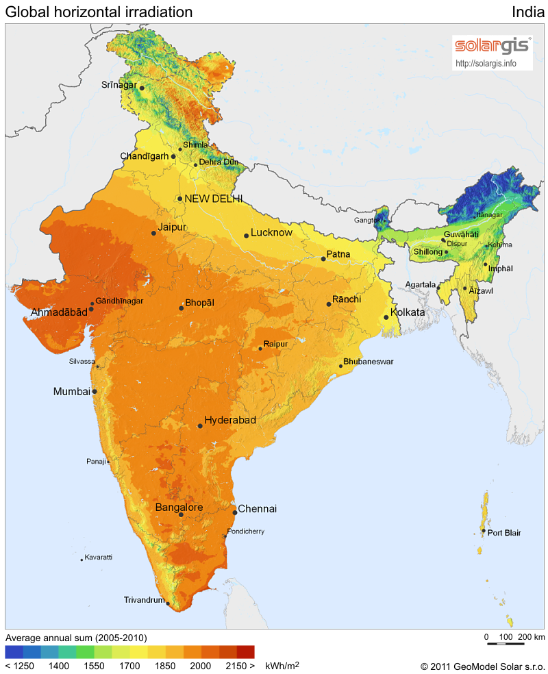
Solar photovoltaic (PV) is already a proven technology for energy generation [3]. Worldwide, the grid-connected solar PV continued to be the fastest growing power generation technology [4, 5], with a 55% increase in 1 year with a cumulative installed capacity of 3.1 GW in 2005, up from 2.0 GW in 2004 [6]. In a similar way, the Indian solar energy sector has been growing rapidly, for the past few years, mainly due to the government's initiative such as tax exemption and subsidies. The other factors are the country's geographical location and huge gap between energy demand and generation. All these factors are opportunities for India to become one of the most rapidly emerging solar energy markets in the world. The government of India is ambitious about its national solar mission that targets to achieve 10,000 MW by the year 2017 and 20,000 MW by the year 2022 [7]. To reach this target, one requires many innovative ways including an attractive national policy for solar industries. Looking at the grid-interactive power generation, the total installed capacity of grid-connected solar power as of June 2011, which is the cumulative capacity based entirely on PV technology, is 39.6 MW and 979.4 MW in April 2012, and off-grid capacity is 85 MW [8]. This shows that the total cumulative solar capacity has increased 25 times in less than a year due to thrust on solar power. From the study growth of photovoltaic in India, on an average, about 45% annual increase is noticed during the years 2000 to 2009. If we look at the state-wise grid-connected solar power generation, Gujarat alone contributed to a total of 654.8 MW. This shows that the government of Gujarat is contributing more than 65% grid-interactive solar power generation [9, 10]. Fortunately, the state of Gujarat is located in the sunny belt (>2,000 kWh/m2) with a clear bright weather for 250 to 300 days per year and receives maximum annual global radiation [11]. More importantly, Gujarat has attracted many industries with its proactive policies and firm commitment.
From the study of cost economics of a solar photovoltaic power plant, the PV module cost is about 45% and that of the other accessories like transformers, cables, inverters, civil works, etc. comes to about 55% [12]. Additionally, the cost of the power plant also depends on the land value. As the cost of solar photovoltaic is continuously decreasing, the major challenge now lies on the land cost. Land is becoming a scarce resource in India in recent years, and per capita land availability is low [6]. Land is often considered as the topmost challenge for deploying solar energy technology [13]. In view of the above, our study is based on using the available land in an effective way. Towards this direction, national highways are studied for energy generation using solar photovoltaic technology. To demonstrate our approach on the use of land and its solar potential, two areas, namely Ahmedabad-Rajkot national highway road and Ahmedabad-Vadodara national expressway, are taken for modelling. Our concept in the form of a schematic diagram is shown in Figure 1. The total span of the Ahmedabad-Rajkot national highway is 205 km, and that of the Ahmedabad-Vadodara national express highway is 93 km [14, 15]. For the purpose of modelling, we have used two software programs - Google Earth Pro and PVsyst simulation softwares [16, 17].

A schematic layout of the national highway.
There are other approaches and methods of using solar photovoltaic technology on highways, for example, using solar-powered LED roadway lighting [18], security lighting, highway changeable message [19], etc. Although these are very important applications, in terms of power generation or power saving, they are almost negligible in comparison to the approach that we have suggested in our paper. Also, one can see the cost-oriented modelling and design optimization for alignment [20] to determine operation and engineering cost of the highway.
The rationale behind the proposed study is to explore the effectiveness of using the national highway and to enlarge all the factors to generate energy. The additional advantage of using the space above the road highways for installation of solar panels is the shading on the roads. This results in improved vehicle efficiency by reducing energy losses due to heat inside the vehicle [21] and also improves the life of the tires of all vehicle wheels due to the shade derived from the road. Combining, the two will result in both improved economy by energy generation and improved efficiency of the vehicle at the same time. One more advantage of the shade over the road is the life of the road and reduction of the cost due to road maintenance. It is a usual phenomenon on many roads that soon after the rains, pot holes usually develop. This will become a history if all roads are provided with solar panels above them.
Our study thus proposes a new idea on the effective use of roadways and also an opportunity to meet the major challenge for the industry, i.e., land availability for the grid-interactive solar power plants. Although our study shows many advantages, one needs to take a few extra measures for proper implementation. For example, one needs to take care of fixing the solar panels to the base firmly onto the structure. Fixing the solar panels at an elevated location, say about 9 to 10m above the ground level, is vulnerable to heavy wind during the storm or rainy days. It may pose a problem for the stability of the solar panels as compared to the ones close to the ground. With extra care of fixing, the panels may overcome this problem. Another problem may be from the dust and smoke particles due to movement of the vehicles. However, as many national roadways are wide and generally much cleaner than other roads, for example, village roads, narrow city roads, or state roads, in any case, one needs to make special arrangement of cleaning the panels on a daily basis as compared to normal panels on the ground away from the road traffic or remotely located panels, where cleaning of panels is done once in a week or 10 days. If all or most of the vehicles follow the Euro standards as regards to smoke emissions, then there will be less pollution problems related to vehicular traffic on the panels. Thus, although there are a few issues to be considered if one follows the ideas of our present study, the disadvantages can be tackled with proper planning - mainly on firm fixing of the panels and regular cleaning of the solar panels.
Methods
The modelling of our present study is done through PVsyst and Google Earth Pro software programs. Before presenting the methodology, brief details of the software are presented in the following.
The software programs
Among various software programs, PVsyst simulation software is popular to analyze the detailed performance of the solar plant in field conditions. It can be used in many ways, for example, to investigate the different loads on the system, to estimate the size of the system, to determine the optimal size of the panel, to assess the energy production in the system, etc. The other various capabilities and options available in the PVsyst software simulation can be seen in [17]. PVsyst, a PC-based software package, can also be used to study the sizing and data analysis of complete PV system. It is used for different designs and sizes of the system. It can evaluate monthly production and performance. It also performs economic evaluation of the PV system at the design stage itself. Its application performs detailed simulation and also shading analysis according to several dozens of variables.
Google Earth is a popular software to view satellite imagery, maps, terrain, 3D building, etc. and for research studies [22–24]. It also provides tools to analyze and explore places with realistic views of an area and navigation through directions. The different features and high quality of satellite maps [25] available through Google Path allow navigating through the Earth, finding addresses and location, marking location, etc. It is also helpful in obtaining the coordinates of different locations. The other various capabilities and options available can be seen in [16]. This can be used by linking the data with GIS software. Another better way of studying is to use the more advanced version of Google Earth - namely ‘Google Earth Pro.’ This is used in our study for more accurate results. With high-resolution imagery, it offers a comprehensive geospatial database for roads and historical imagery. One can visually see the surface of the Earth with all the field information. This is a very useful feature as one can get the field information without actually visiting the location. Since our present study is more of a regional nature, Google Earth Pro is found to be suitable in our study. Google Earth Pro, with the integrated measurement and drawing tools, is also used for radius and area measurement. Thus, this software helps for identification of thick vegetation, bridges, and unusable road locations with its dimensional parameters.
Figures 1 and 2 show a schematic diagram prepared to show an example of a typical national highway. Each lane width is 3.5 m as specified by the National Highway Authority of India [14] and ground-checked by the authors. The roadside plantations with trees are also shown symbolically in the figure. One can design different configurations based on the area available on the road and the size and technology of the solar panel as detailed below.

A schematic layout of the national highway with solar photovoltaic panels on its roof.
In the following, details of the two national highways, namely Ahmedabad-Rajkot and Ahmedabad-Vadodara, are presented.
Details of the sites
Figure 3 shows the Ahmedabad-Rajkot national highway road map with small towns on its way. For modelling, the potential of solar energy generation using solar photovoltaics, an area of about 1,355 m2 is chosen for the four-lane road. More details are given in Table 1.

Ahmedabad-Rajkot national highway shown using Google maps.
Figure 4 shows the Google map for the Ahmedabad-Vadodara national express highway. The same area as before has been used for computation to find out the potential of solar energy generation using solar photovoltaics.

Ahmedabad-Vadodara national express highway shown using Google maps.
For the modelling part, we have chosen the four-lane Ahmedabad-Rajkot national highway and six-lane Ahmedabad-Vadodara expressway (four-lane highway with two service roads) for finding the potential of solar energy generation. The total span of the Ahmedabad-Rajkot national highway length is 205 km. Each lane on the national highway has a width of 3.5 m [26], and thus for two lanes, the total width is 7m. For both sides (to and fro), the total width available for solar panels above the road is 14m. The width of the road has been also measured by the authors with measurement tapes from various places along the national highway. This also helps to measure the accuracy of Google Earth Pro software for modelling purposes. Similarly, for the Ahmedabad-Vadodara express highway, the span of the road is 93 km in length [14, 15]. The width of the express highway is 20 m, out of which 14 m is for the two-lane national express highway. Additional 3 m is the extra road available on both sides of the national express highway or service road. This is again verified and ground-checked by the authors while travelling all along the national highways and measuring road width using measurement tapes. Additional information on the national highways is also provided from virtual observation of the road using Google Earth Pro software, for example, the lengths of the road unavailable due to certain environmental reasons like bridges, crossing, unusable road, thick vegetation, etc. These parts have been identified with high resolution with high accuracy in measurements [16] using Google Earth Pro software modelling without actually making the ground observation (but verified on various different places by travelling all along the national highway). More information on these aspects is shown separately in Annexure I in Additional file 1 for the Ahmedabad-Rajkot national highway and Annexure II in Additional file 1 for the Ahmedabad-Vadodara national express highway
The data
For the grid-connected system, the basic input parameters required for modelling are PV component database, grid inverter database, geographical site information, and monthly meteorological data for horizontal global irradiance and temperature. In the present study, a silicon-polycrystalline module Titan 24–100 of the Titan Energy systems (Secunderabad, Andhra Pradesh, India) has been used. Each solar module has a maximum power output of 100 W. For the grid inverter, Sputnik Solarmax 50 C (Länggasse, Bienne, Switzerland) has been used that works on a 50-Hz frequency, a voltage range of 430 to 800 V, and a power rating of 50kW as one unit for our calculation. The unit considered here is extended to the entire length of the highway. The meteorological data are acquired from METEONORM version 6.1.0.23 (Fabrikstrasse, Bern, Switzerland) [12, 27].
In Table 1, the information with more details for the solar panels such as solar module technology, power rating, and related module specifications for a 50-kW photovoltaic system is provided. This is considered as one unit for the purpose of calculation, which will be extended for the entire length of the highway. Accordingly, 504 numbers of modules are used for both Ahmedabad-Rajkot national highway (four lanes) and Ahmedabad-Vadodara highway (four lanes wo service roads). The panels are tilted at an angle of 23°. This tilt is chosen equal to the latitude for the Ahmedabad site (23.067°).
Solar panel orientation
It is well known that the highest amount of energy generation can be produced through solar photovoltaic panels oriented exactly to the south in the northern hemisphere [28, 29]. Also, if the orientation of the solar panel is other than south, then the amount of energy generation is less. The orders of decrease in energy generation for different directions are the East, the West, and the North, based on the compilation of a 50-kW system using PVsyst software [17]. We suggest that the panel orientation should be taken extra care while designing the mounting of panel; this helps to utilize energy available from solar panel as maximum as possible by keeping the orientation towards the south direction. As described before, due to the limitation of the PVsyst software, the simulation is considered only for 50 kW, a small area covering the national highway roads.
In Figure 5, the solar panel design configuration considered for our study of the Ahmedabad-Rajkot highway is shown as a schematic diagram, for two lanes. As described earlier, the width of the lane is 3.5 m for a multi-lane national highway [26] and the same is considered in our model study. Considering the width of the two lanes of a national highway, the schematic diagram shows a 7-m width of solar panels for each of the four lanes with a separation gap between the roads for tree plantation, etc. of 3 m, as shown in Figure 5. This configuration is computed using PVsyst simulation software in order to get the total solar energy generated from the panels on the four lanes. As a sample, 84 solar modules in each single row of, say, X direction (lengthwise) and a series of six rows of solar panels in another, say, Y direction (widthwise) are considered. Based on the dimensions of the Ahmedabad-Rajkot highway, these possibilities of keeping solar modules are chosen. Such a design is arbitrary but helps to compute the parameters quickly. This configuration approximately provides a maximum of 50 kW of power output from PV modules. However, the results from this model can be extended to any length of a national highway as required.

A design configuration for Ahmedabad-Rajkot national highway used for simulation in PVsyst simulation software.
This design configuration suggested in our study requires a rigid structure for the photovoltaic panel mounting. The type of structure is based on the number of solar panels for installation in the available area. For example, for the four-lane Ahmedabad-Rajkot national highway, 84 modules of 100 W each can be configured in one row, and thus, six such rows in 14-m width of the road require 504 modules for 89-m length along the road. Such a design is arbitrary and can be varied depending on the size and power rating of a particular photovoltaic technology.
In the same fashion, Figure 6 shows a schematic layout for the photovoltaic installation over the Ahmedabad-Vadodara national express highway. Similar to the Ahmedabad-Rajkot highway, we have chosen (9 + 9) modules widthwise and 56 such rows (28 + 28) with a separation of 2.5 m between rows of the modules from the module-to-module shading calculation. It is observed that the height of the module is 1.69 m; a total of 504 such modules of the same size with 100-W capacities can be configured along the Ahmedabad-Vadodara express highway that has a width of 23 m (10 + 10 + 3 m). Such a design is arbitrary and can vary depending on the size and power rating of a particular photovoltaic technology being used.

A design configuration for Ahmedabad-Vadodara national express highway used for simulation using PVsyst simulation software.
The different schematic configurations shown for the Ahmedabad-Rajkot national highway and the Ahmedabad-Vadodara express highway are necessary due to different orientation directions of the road. It may be noted that most parts of the Amedabad-Rajkot route is oriented towards near the east-west direction and for the Ahmedabad-Vadodara is near south-north direction. Accordingly, the unit considered for modelling using PVsyst software is the east-west direction for one model and the north-south direction for another model.
As shown in a schematic diagram, one needs to construct a structure above the highway road using firm RCC beams or stainless steel structure materials. These structures as a roof probably with stainless steel cladding provide a rigid structural support to the solar panel installations. Depending on the site location, one can construct a structure avoiding the trees, thick vegetation, level crossing, or other obstructing structures en route.
As an example, the effective energy at the output of an array as a function of local time of a day for December 20 using meteonorm radiation data for Ahmedabad averaged over a period of 20 years, 1981 to 2000, can be seen [12]. The amount of effective energy supplied to the grid per day as a function of time of the day is also shown with the figure [12].
Modelling the national highways
In Table 2, we describe the various parameters and dimensions considered to estimate the solar potential along the Ahmedabad-Rajkot national highway, i.e., the length of the highway identified suitable or unsuitable for the solar photovoltaic system installation as a roof of the road for energy generation. As described earlier, it has a length of 205 km with a two-way road (four lanes) with a width of 14 m. Thus, the total area (Area = Length ×Width) available for solar panel installation is 2.87 km2. Although the length of the highway is 205 km, all along the highway, the road is not usable due to certain parameters, for example, environmental issues like thick vegetation, bridges on ponds, or overhead bridges for road crossings with other roads. We have also not considered the portions of the road either under construction or not clearly visible with the Google Earth Pro software with high-quality resolution and clarity [16]. Accordingly, Table 2 shows that out of 2.87-km2 total area available on the Ahmedabad-Rajkot national highway, 0.2 km2 is found to be unavailable or, say, inappropriate for installation of the photovoltaic system due to certain factors as stated above. Hence, the effective area available on Ahemdabad-Rajkot national highway is 2.67 km2.
Similar to the Ahmedabad-Rajkot highway, we have considered the Ahmedabad-Vaododara expressway. As described before, it has four lanes each with 3.5-m width and additionally has a service road of 3-m width on both sides of the road. The length of the expressway is 93 km with a total available road width of 20m (4 × 3.5 + 2 × 3). Accordingly, the total area available for solar panel installation is 1.86 km2. Out of the available area, a total of 0.14 km2 is unavailable due to the same environmental issues which have been discussed earlier for the Ahmedabad-Rajkot highway. Thus, similar to the Ahmedabad-Rajkot highway, the approximate effective area available on the Ahmedabad-Vaododara express highway is 1.72 km2.
Apart from the computation of solar potential for the national highway using a series of solar panels mounted on the road roof area, we have also considered two-layer solar panel installations. In an earlier study [12], it was demonstrated that two-layer solar panels one above the other showed about 70% increase in solar potential. In this context, it is of interest to observe the variation of the output for a two-layer solar panel in two perpendicular directions - one solar panel oriented towards south and lying nine (in rows) along the east-west direction and the other solar panel oriented towards south and lying nine (in rows) along the north-south direction. Interestingly, a large variation is observed between the two-layer solar panel configurations. The results are presented in Table 3.
Table 3 shows a comparative study with detailed information of single- and two-layer solar panels for enhancement of energy generation based on the concepts discussed in great detail in our previous paper [12]. The results shown here are for all the solar panels oriented towards the south direction. However, the distribution of the rows are more towards the north-south direction in one case and more towards the east-west distribution in the other case as shown in the schematic diagrams (Figures 5 and 6). Such configuration in modelling helps to understand the results for the Ahmedabad-Rajkot national highway (near east-west direction) and the Ahmedabad-Vadodara (near north-south direction) express highway. The analysis and the results presented are for different months and for the annual energy generation. It can be seen that the two-layer solar panel energy generation is more viable for the north-south-oriented highways as compared to east-west-oriented roadways. This is mainly due to the position of the sun in the sky which moves from the east to the west. Such moment casts more shadow on the east-west-distributed rows of the solar panels as compared to north-south-distributed solar panels.
Results and discussion
Based on the modelling results along the two national highways, a few interesting observations can be made as compiled in Table 4. Although the Ahmedabad-Rajkot and Ahmedabad-Vadodara national highway lengths are 205 and 93 km, respectively, the effective length of the highways for erecting the road rooftop structures for placing the solar panels are 185.4 and 85.8 km, respectively. This way of selection of the highways is based on various factors as described earlier and also shown in Table 2. From our modelling results, a 115-MW power generation along the Ahmedabad-Rajkot national highway is possible. However, due to the environmental and other restrictions, only a 104-MW electricity generation is feasible. However, if we use innovative concepts of two-layer solar panels one above the other, the energy generation can be enhanced. If we compute the energy generation for the whole year, the cumulative energy that can be generated is 163 GWh. This computation is based on the results shown in Table 4. For example, the cumulative annual energy generation for a 50-kW system is 78,074 kWh (Table 3). Accordingly, for a 1-MW system, the energy generation is 1,561,480 kWh (78,074 kWh × 1,000 kW/50 kW) which is equivalent to 1.56 GWh.
For the Ahmedabad-Rajkot highway, the energy generated by a 50-kW system (Table 3) is 78,074 kWh and the dimension for solar panel layout is 89 m × 17 m. This means that a highway road with a width of 17 m requires 89 m in length for 50-kW photovoltaic system installations; hence, for 1 MW (i.e., 50 kW × 20), the required length of the highway, i.e., 89 m × 20, is equal to 1,780 m (1.78 km). More clearly, one can say that by maintaining the width of the road as 17 m, one requires a 1.78-km length of the road to generate 1-MW power. This value can be used to compute the potential for any length of the road.
The total length of the Ahmedabad-Rajkot national highway is 205 km, out of which the total effective length available is 185.4 km (based on the computation given in Table 2; 185.4 km/1.78 km), and 104 MW is possible for the entire length of the highway. This way, for 104-MW systems, the energy generation is 163 GWh. This is for a single-layer solar panel system. If the solar panels lay one above the other with 1-m separation, the energy generation (Table 3) increases to 190 GWh; for 2-m separation, it is 216 GWh; and for 3-m separation, it is 229 GWh. One should note here that these computations are based on 50-kW systems as one unit and the direction of the national highway is oriented exactly in the east-west direction. Similar computations are shown in Table 4 for the Ahmedabad-Vadodara national expressway. Here again, the computations are based on 50-kW systems as one unit, and the solar panels are distributed in the south-north direction. Accordingly, 61-MW electricity generation is possible for the Ahmedabad-Vadodara expressway, and 96 GWh of cumulative annual generation is possible for single layer, 115 GWh for two layers of 1-m separation, 132 GWh for 2-m panel separation, and 140 GWh for 3-m separation, as presented in Table 4.
Conclusions
In this paper, we have suggested, first time ever of its kind, an approach to utilize solar energy to meet the global challenges like climate change, pollution, and energy insecurity [13] and also to address the biggest challenge for the photovoltaic technology, i.e., land cost. Indian roads are paying a very vital role in the economy through transportation, whose share has been increased before 2000 only to 60% in total sharing of 40% with railways [30]. This means that efficiency of the vehicle and life of the road are equally important. Through this paper, we are also answering some of these issues. It is well known that the availability of land is becoming more expensive and also becoming a rare commodity. In view of this, our study proposed a new concept to use the existing land in a more effective way. Towards this direction, an attempt has been made for the possible use of the national highways presently being used for transportation only. Our suggestion is that they can also be utilized for power generation. For this purpose, with one-time investment, one can construct a simple elevated structure covering the national highway roads. For this purpose, we have considered two case studies, one along the Ahmedabad-Rajkot highway and the other along the Ahmedabad-Vadodara expressway. It may be noted that the Ahmedabad-Rajkot highway is oriented near the east-west direction and the Ahmedabad-Vadodara expressway is oriented near the south-north direction. Accordingly, using PVsyst software, solar panel configurations have been constructed that have an area equivalent to generate 50 kW of electricity. This is considered as one unit for computation to estimate solar potential on a national highway to enhance the power generation. We have also incorporated two layers of solar panels that lie one above the other. Such an idea has already been demonstrated on enhanced power generation [12].
Using Google Earth Pro software, the national highways are carefully scanned and the part of the road that cannot be used for structural construction due to environmental and other factors has been deleted in the estimation, and the details are given in Annexures I and II in Additional file 1.
From the results of our study, 104 MW of electricity is feasible along the Ahmedabad-Rajkot national highway. It is observed that two-layer solar panels installed along the national highway oriented towards south lying in the south-north direction (this direction is the spread of solar panels in rows) produce more energy as compared to solar panels oriented towards south lying in the east-west direction (this direction is the spread of solar panels in rows) on the national highway. The results are summarized in Table 3.
We can suggest that the same concept can be extended for use on the 52,584-km national and state highways in India that have four lanes or more [14], for example, the four-lane Golden Quadrilateral highway which is 5,839 km. The Golden Quadrilateral [14] is a highway network connecting India's four largest metropolises: Delhi, Mumbai, Chennai, and Kolkata, thus forming a quadrilateral that can have an installation power of approximately 4,418 MW. Similarly, it is possible for the four-lane north-south to east-west (NS-EW) Corridor highway of 7,300 km. The NS-EW Corridor highway is the largest ongoing highway project in India. It consists of four/six-lane expressways connecting Srinagar, Kanyakumari, Porbandar, Silchar [14], etc. Accordingly, the NS-EW Corridor highway has 5,524-MW capacity of power generation. In a similar manner, we recommend to initiate solar panel installations on all the train trackways also. This will open up large potential of power generation in a very short period of time which is very much needed in India to have aggressive industrial growth which is presently in strong need for power.
As detailed earlier, a total of 104-MW potential of solar energy generation exists along the Ahmedabad-Rajkot national highway and a total of 61-MW potential of solar energy generation exists on the Ahmedabad-Vadodara national express highway. This way, huge potential of solar energy generation exists on the national highways with capacities based on the length. This leads to not only meeting the energy demand but also reduction in CO2 emissions by minimizing dependency on conventional sources [31], hence promoting renewable energy resource on a very large scale, and this is the best answer for the national threats called GHG emission for any country [32]. Power generation using this concept generates huge amount of electricity without combustion of fossil fuels, as electricity generation through fossil fuels is the largest source of CO2 emission [33], and hence, this helps to reduce the dependency on fossil fuels and transportation of fossil fuels. A more detailed study on environmental damages by CO2 emission and transportation can be seen in [34, 35].
In summary, the national highway space can contribute to the huge amount of energy generation without extra cost for the land. By this, we can also say that this idea can be a part of the key concept of solar grand plan [36]. Apart from this, there are various fringe benefits. For example, if implemented, it improves vehicle efficiency, use of minimum energy for air conditioning vehicles, more tire life due to shade, etc. Also, another fringe benefit of this road rooftop solar project is increase of the life of the road from wear and tear on the highways, and this helps to reduce the fund requirement for road repairs. Another benefit is rainwater harvesting at selected locations. This increases the groundwater level and helps to reduce the fluoride and arsenic content in the groundwater. In summary, we can say that this approach is also the answer for the various concerns of sustainable transport and helps in reaching a goal for a sustainable transport system [30]. For all the above ideas, to see the light of day, there is an urgent need for an attractive policy by the government of India to increase the solar potential if one dreams to realize it in 1-year duration.
Authors' information
PS, an M.Sc., M.Tech, and research associate in the Solar Research Wing, is involved in a research and development program of solar energy technology in GERMI Research Innovation and Incubation Centre (GRIIC), Gujarat, India, with more than 5 years of research and industrial experience in R&D of solar photovoltaic energy technology. She is involved in setting up various solar research laboratories. She is an M.Tech. from the School of Energy, Devi Ahilya Vishwavidyalaya (DAVV), Indore, India. She has also done M.Sc. in Physics with solar specialization. She has worked with a dedicated unit from the Ministry of New and Renewable Energy Government of India, Solar Energy Center on ‘Design and development of 20 kWp roof top PV power plant at SEC’ in Gurgaon, India. She has published her work in international journals and presented her research work in various national and international conferences. TH, a Ph.D., Director of GRIIC, Gujarat, and earlier Head of Magnetotellurics, National Geophysical Research Institute, has done outstanding contributions in the field of deep electromagnetics both on land and marine environment. TH is one of the top scientists among the geomagnetism and electromagnetic scientists in the world. His pioneering works are related to oil exploration, geothermal energy assessment, deep crustal studies, tsunami studies, earthquake studies, etc. He is instrumental in introducing a new geophysical technique - marine magnetotellurics - in the Gulf of Kutch for hydrocarbon exploration that has delineated 4-km-thick buried sediments below the volcanic cover. This work was initiated as a part of international cooperation with Scripps Institution of Oceanography, USA. This has opened up a new scenario of search for oil in the Gulf. He has received a National Mineral Award from Ministry of Mines, Government of India, at an early age of 40. He was chosen as the best scientist by the Government of Andhra Pradesh. He was elected to the prestigious Russian Academy of Natural Sciences, Moscow, Russia. He is an elected fellow of the Indian Geophysical Union and a fellow of the Andhra Pradesh Academy of Sciences. He has taken up controlled source electromagnetic modelling studies for gas hydrates as a part of his research at the University of Texas, Austin, USA, as a visiting scientist and also carried out tsunami studies at the University of Tokyo, Japan, as a visiting professor.
References
Lal S, Raturi A: Techno-economic analysis of a hybrid mini-grid system for Fiji islands. Int. J. of Energy and Environ. Engineering 2012, 3: 10. 10.1186/2251-6832-3-10
Oyedepo S: Efficient energy utilization as a tool for sustainable development in Nigeria. Int. J. of Energy and Environ. Engineering 2012, 3: 11. 10.1186/2251-6832-3-11
Zweibel K: Should solar photovoltaics be deployed sooner because of long operating life at low, predictable cost? Energy Policy 2010, 38(11):7519–7530. 10.1016/j.enpol.2010.07.040
Dinçer F: Overview of the photovoltaic technology status and perspective in Turkey. Renew. Sustain. Energy Rev. 2011, 15(8):3768–3779. 10.1016/j.rser.2011.06.005
Bhutto AW, Bazmi AA, Zahedi G: Greener energy: issues and challenges for Pakistan—solar energy prospective. Renew. Sustain. Energy Rev. 2012, 16(5):2762–2780. 10.1016/j.rser.2012.02.043
Renewable Energy Policy Network: Renewables global status report. (2006) Accessed 21 June 2012 http://www.ren21.net/Portals/0/documents/activities/gsr/RE_GSR_2006_Update.pdf (2006) Accessed 21 June 2012
Ministry of New and Renewable Energy, Government of India:Jawaharlal Nehru National Solar Mission: Towards Building SOLAR INDIA. (2009). Accessed 20 Feb 2011 http://www.mnre.gov.in/file-manager/UserFiles/mission_document_JNNSM.pdf (2009). Accessed 20 Feb 2011
Ministry of New and Renewable Energy, Government of India: Achievements. (2013). Accessed 19 Sept 2012 http://www.mnre.gov.in/mission-and-vision-2/achievements/ (2013). Accessed 19 Sept 2012
Press Information Bureau, Government of India: Progress under Jawaharlal Nehru National Solar Mission. (2012). Accessed 19 Sept 2012 http://pib.nic.in/newsite/erelease.aspx?relid=83632 (2012). Accessed 19 Sept 2012
Gujarat Energy Development Authority: Gujarat - Solar Power Plants as of May-9–2012. (2012). Accessed 19 Sept 2012 http://geda.gujarat.gov.in/media/Solar_Power_PLants_at_a_Glance.pdf (2012). Accessed 19 Sept 2012
GeoModel Solar: Solar GIS India. (2011). Accessed 9 April 2012 http://solargis.info/doc/_pics/freemaps/1000px/ghi/SolarGIS-Solar-map-India-en.png (2011). Accessed 9 April 2012
Sharma P, Harinarayana T: Enhancement of energy from the two layer solar panels. International Journal of Energy and Environmental Engineering 2012, 3: 12. 10.1186/2251-6832-3-12
Jacobson MZ, Delucchi MA: Providing all global energy with wind, water, and solar power, Part I: technologies, energy resources, quantities and areas of infrastructure, and materials. Energy Policy 2011, 39(3):1154–1169. 10.1016/j.enpol.2010.11.040
NHAI (National HighwaysAuthority of India) (2013). Accessed 20 April 2012 http://www.nhai.org/ (2013). Accessed 20 April 2012
Google: Google Maps. (2013). Accessed 17 July 2012 http://maps.google.co.in (2013). Accessed 17 July 2012
Google: Google Earth Pro software. = en (2013). Accessed 11 April 2012 http://support.Google.com/earth/?hl = en (2013). Accessed 11 April 2012
PVsyst SA: User's Guide: PVsyst Contextual Help. (2012). Accessed 8 Dec 2011 htpp://www.pvsyst.com (2012). Accessed 8 Dec 2011
Wu MS, Huang HH, Huang BJ, Tang CW, Cheng CW: Economic feasibility of solar-powered led roadway lighting. Renew. Energy 2009, 34(8):1934–1938. 10.1016/j.renene.2008.12.026
Young WR Jr: Photovoltaic application for disaster relief. FSEC- CR-849–95. Florida Solar Energy Center/University of Central Florida. (1995). Accessed 8 Oct 2012 http://www.fsec.ucf.edu/en/publications/pdf/FSEC-CR-849–95.pdf (1995). Accessed 8 Oct 2012
Jian-xin C, Qing L: Research on cost-oriented modeling and optimization for highway alignment. Procedia Engineering 2011, 15: 3931–3935.
Centre for Urban Forest Research:Why shade streets?: The unexpected benefit. (2007). Accessed 17 July 2012 http://www.fs.fed.us/psw/programs/uesd/uep/products/cufr_673_WhyShadeStreets_10–06.pdf (2007). Accessed 17 July 2012
Sundvall E, Nystrom M, Forss M, Chen R, Petersson H, Ahlfeldt H: Graphical overview and navigation of electronic health records in a prototyping environment using Google Earth and open EHR archetypes. Stud. Health Technol. Inform. 2007, 129(Pt 2):1043–1047.
Conroy GC, Anemone RL, Van Regenmorter J, Addison A: Google Earth, GIS, and the great divide: a new and simple method for sharing paleontological data. J. Hum. Evol. 2008, 55(4):751–755. 10.1016/j.jhevol.2008.03.001
Galway LP, Bell N, Al SSAE, Hagopian A, Burnham G, Flaxman A, Weiss WM, Rajaratnam J, Takaro TK: A two-stage cluster sampling method using gridded population data, a GIS, and Google EarthTM imagery in a population-based mortality survey in Iraq. Int. J. Health Geographics 2012, 11: 12. 10.1186/1476-072X-11-12
Chang AY, Parrales ME, Jimenez J, Sobieszczyk ME, Hammer SM, Copenhaver DJ, Kulkarni RP: Combining Google Earth and GIS mapping technologies in a dengue surveillance system for developing countries. Int. J. Health Geographics 2009, 8: 49. 10.1186/1476-072X-8-49
Facts-About-India.com (2013). Accessed 17 July 2012 http://www.facts-about-india.com/indian-roads.php (2013). Accessed 17 July 2012
Global Meteorological Database: Meteonorm Switzerland. Version 6.1.0.23. (2007). Accessed 17 Feb 2012 http://meteonorm.com/ (2007). Accessed 17 Feb 2012
Mehleri ED, Zervas PL, Sarimveis H, Palyvos JA, Markatos NC: Determination of the optimal tilt angle and orientation for solar photovoltaic arrays. Renew. Energy 2010, 35(11):2468–2475. 10.1016/j.renene.2010.03.006
Chang TP: Performance analysis of tracked panel according to predicted global radiation. Energy Conversion and Management 2009, 50(50):2029–2034.
Reddy AKN, Anand YP, D'Sa A: Energy for a sustainable road/rail transport system in India. Energy Sustain. Dev. 2000, 4(1):29–44. 10.1016/S0973-0826(08)60230-6
Hoffert MI, Caldeira K, Benford G, Criswell DR, Green C, Herzog H, Jain AK, Kheshgi HS, Lackner KS, Lewis JS, Lightfoot HD, Manheimer W, Mankins JC, Mauel ME, Perkins LJ, Schlesinger ME, Volk T, Wigley TML: Advanced technology paths to global climate stability: energy for a greenhouse planet. Science 2002, 298: 981. 10.1126/science.1072357
Yan X, Crookes RJ: Energy demand and emissions from road transportation vehicles in China. Progress in Energy and Combustion Science 2010, 36(6):651–676. 10.1016/j.pecs.2010.02.003
EPA(United States Environmental Protection Agency): Greenhousegas emissions. (2012). Accessed 2 Jan 2013 http://www.epa.gov/climatechange/ghgemissions/gases/co2.html (2012). Accessed 2 Jan 2013
Guerrero-Lemus R, Martínez-Duart JM: Renewable Energies and CO2: Cost Analysis, Environmental Impacts and Technological Trends. In Lecture Notes of Energy, vol. 3. Springer, Heidelberg; 2012.
Krupnick AJ, Rowe RD, Lang CM: Transportation and Air Pollution: The Environmental Damages. Springer, Berlin; 1997.
Zweibel K, Mason J, Fthenakis V: A solar grand plan. Scientific American 298, 64–73 (2008). doi:10.1038/scientificamerican0108–64 http://www.nature.com/scientificamerican/journal/v298/n1/full/scientificamerican0108–64.html Scientific American 298, 64–73 (2008). doi:10.1038/scientificamerican0108-64
Acknowledgements
PS and TH would like to acknowledge VCMT Sri Tapan Ray for all his encouragement and also all the research, technical, and scientific staff of GERMI for the support.
Author information
Authors and Affiliations
Corresponding author
Additional information
Competing interests
The authors declare that they have no competing interests.
Authors' contributions
PS carried out all the computation, system designing, modelling analysis, software simulation, and field measurement and drafted the manuscript. TH conceived of the study and participated in its design and coordination. Both authors read and approved the final manuscript.
Electronic supplementary material
40095_2012_49_MOESM1_ESM.docx
Additional file 1: Annexures I and II: Annexure I: List of the places in length (m) along with latitude and longitude. Length of these places is eliminated in the energy calculation for Ahmedadad-Rajkot national highway. Annexure II:List of the places in length (m) along with latitude and longitude. Length of these places is eliminated in the energy calculation for Ahmedadad-Vaoddara national highway. (DOCX 19 KB)
Authors’ original submitted files for images
Below are the links to the authors’ original submitted files for images.
Rights and permissions
Open Access This article is distributed under the terms of the Creative Commons Attribution 2.0 International License (https://creativecommons.org/licenses/by/2.0), which permits unrestricted use, distribution, and reproduction in any medium, provided the original work is properly cited.
About this article
Cite this article
Sharma, P., Harinarayana, T. Solar energy generation potential along national highways. Int J Energy Environ Eng 4, 16 (2013). https://doi.org/10.1186/2251-6832-4-16
Received:
Accepted:
Published:
DOI: https://doi.org/10.1186/2251-6832-4-16