
Abstract
Coastal cities contrive to spread their transformative influence both into the hinterland, along the coastline, and into the coastal waters themselves. These effects will be intensified in urban agglomerations as the concentration of population and allied activities are more pronounced there compared to the inland regions. Indian coastal cities are no exception, and it is high time to delineate these hazard-prone regions and implement proper mitigation and adaptation strategies at city scale. This review article provides an assessment regarding quantification, management and climate change impacts of flood risks in Surat, Mumbai, Chennai and Kolkata, which are the most populated coastal cities in India. The flood impacts considered in the existing or prevailing analyses are associated with adverse effects on population, land use of cities, transportation and economy caused by different types of riverine and urban flooding, though coastal flooding, tsunami and storm surge effects are less studied. Mumbai and Kolkata are relatively progressive in the assessment of flood risks and adaptation. The present article also suggests strategies to evaluate the relative progress in the assessment of past and future risks and adaptation. We also discuss the mitigation and adaptation strategies considering the historical importance of these cities. We propose that the strategies should be implemented considering public opinion and should be initialized at the grass root level. Though it is technically difficult to re-plan the city structures in the current scenario, it is possible to adapt to and mitigate the effects of natural hazards through suitable planning and management with the integrated cooperation and involvement of citizens and government as well.
Introduction
Urban centres are dynamic interfaces and regions of intense economic activities. The growing significance of urban areas is recognized by including Goal 11 (sustainable cities and communities) in the United Nations Sustainable Developmental Goals (SGDs). Cities are knowledge and innovation hubs, that can drive the urban system towards better governance of health and the climate within cities, and are centres which catalyse societal transformations (de Oliveira and Doll 2016). Most of the urban regions are located in coastal areas (Small and Nicholls 2003). As urban areas grow, correspondingly the population and its allied pressures also increase in the coastline. In addition to natural changes, these coastal environments face multifaceted hazards due to anthropogenic fossil fuel combustion, fertilizer use, sewage input, industrial activities, tourism, overfishing, aquaculture farms and marine traffic (VishnuRadhan et al. 2014). The coastal cities are important drivers of socio-economic development as well as sources of environmental challenges (von Glasow et al. 2013), and nearly half of the world population now lives within 200 km of the coast, and it is expected to reach 75% by 2025 (UNESCO 2009; Creel 2003). Currently, India is the second most populous nation and has large coastline compared to most of the other nations around the globe; the pressure in its coastal zones is beyond imagination. India ranks 18th in terms of coastline length, and the total coastline is 7517 km including the Andaman and Nicobar Islands in the Bay of Bengal and the Lakshadweep Islands in the Arabian Sea (IYB 2007). The majority of the population of this agriculture-dependant country in the Indian Ocean rim is depended on the Indian summer monsoon for their survival and daily livelihood. As the monsoon is one of the most unpredictable climate phenomena in the globe (Jaiswal et al. 2018; Mahmood et al. 2018; Shahi et al. 2018), it can substantially affect the population not only in terms of their basic livelihood, but also by inducing geohazards such as flash floods and inundation. In the case of coastal cities, the effect will be exacerbated as these are densely populated and are prone to sea-level rise, storm surges and tropical cyclones, of which recent studies portraits are intense under climate change scenarios (Mendelsohn et al. 2012; Rahmstorf 2017; Vitousek et al. 2017).
The city scale has ever been more recognized for risks management and adaptation in recent years (Bai et al. 2018; Ürge-Vorsatz et al. 2018; Rodriguez et al. 2018; Solecki et al. 2018). Analysis within the city boundary is more relevant for local administrations such that decisions for adaptation can be facilitated at an applicable level of governance. There are a number of significant impacts on cities which are directly related to climate change such as surface sealing by concrete (urban heat islands) and urban floods (Lindley et al. 2006). The developing countries are having greater vulnerability than developed countries at city scale, because of rapid increase in population as compared to the capacity of infrastructure, resulting in the deficit of their adaptation measures towards climate variability and future exposure to flood risks (Hunt and Watkiss 2011). The definition of the coastal megacity is debatable in the literature because of the inconsistency in the threshold of megacity which is 1, 8 and 10 million people (Cross 2001), but the United Nations has defined the megacity as having population more than 10 million (UN 2008). We have considered coastal megacities following Nicholls and Small (2002). Kolkata is located 145 km away from the coastline, but is considered as a coastal megacity because of the direct effect of marine processes and deltaic settings (Sekovski et al. 2012). Though Surat is not a megacity, the city is growing in terms of population and infrastructure and can be a potential future megacity.
This review article presents evidence-oriented flood risks and adaptation strategies in select coastal cities in India based on published literature, in addition to reviewing the methodology of information utilization. We also delineate the potential impacts of flood-induced risks in the select coastal cities: Surat, Mumbai, Kolkata and Chennai. According to the previous studies (Revi 2008; Bhat et al. 2013; Ranger et al. 2011; Joerin et al. 2012; Nicholls et al. 2008; Dasgupta et al. 2013), the most important risks posed by floods in Indian coastal cities are primarily due to (1) the riverine flooding and extreme precipitation, (2) the effect of cyclonic storms, tsunamis and tidal inundation, (3) failure in urban planning and unsustainable land-use practices. Flood risks are usually coupled with cyclones, storm surges, tides and tsunami across different geographical locations having a difference in impact categories, including riverine flooding, urban flooding, population growth, transportation, energy demand and climate variability. Füssel and Klein (2006) have mentioned the importance of qualitative approaches over quantitative estimation during the assessment of large future risks to minimize the uncertainty. The literature mentioned in this review is supposed to be indicative only of the true scope and extent of flood risks and climate change impacts along the major Indian coastal cities.
This study integrates the existing scientific studies about floods (impacts, methods and adaptation) in major Indian coastal cities precisely to make it easy for other researchers who want to pursue advancements in the similar domain. This work considers the assessment of different methodologies also, particularly techniques adapted in different studies, which results in lack of consistency. Consequently, several studies have highlighted different methods, including the action of climate models, socio-economic scenario, index-based approach, GIS and the monetary valuation of market/non-market impacts. Comparability among different approaches may assist more easy transfer of useful discoveries and observations between cities. The existing coastal city studies show that sectoral stakeholder engagement is the key to maximize the benefits of adaptation activities. We are highlighting the need of future experiments relevant to overall objectives and necessary actions of flood impacts coupled with climate change scenario. The goal of this review article is to evaluate the causes, potential risks and measures to control them at city scale under the pressure experienced along the dynamic coastline of India and is intended towards the assessment of flood impact considering all possible scenarios. Moreover, there are no review articles exclusively dedicated in addressing the flood impacts and adaptation considering the Indian coastal urban regions.
Study area
In this study, four maximum populated coastal cities along the Indian coastline, two at the west (Surat and Mumbai) coast and two at the east (Chennai and Kolkata) coast, are chosen. The selection of cities from both the west and east coasts is due to the fact that the climatic/oceanographic conditions along the two coasts are different (Fig. 1). These cities are vulnerable to floods by multiple causes such as rivers in the city itself (adjacent or central), faulty urban design and planning, the dynamic and vulnerable coastline, flash floods, storm surges, cyclones and tsunamis. Table 1 indicates the causative factors leading to the occurrence of floods in these coastal cities.

Locations map of study areas
Surat is a historical coastal city located on the bank of the Tapi River, Gujarat state. The Surat port was an active hub of trade and commerce in the past, and the city reached its utmost prosperity during the sixteenth and seventeenth century. Surat was also the main port of the Mughal Empire (Gupta 1987). The British East India Company established one of its first Indian factories at Surat in 1612, and this English factory has been called the cornerstone of the British Empire in India (Rawlinson 1920). The colonial past of the city resulted in providing well-documented past flooding events in the city. Imperial Gazetteers and written historical accounts documented details of the past floods prior to the instrumental records (Kale et al. 1996). The construction of an inner wall in the city was commenced by the British in the year 1664 as a flood protection structure with gates that were closed in the event of a flood, and the construction of the entire wall was completed in the year 1707. The city area expanded from 8.12 km2 (prior to 1961) to 326.5 km2 in 2009 (SMC 2011). The city can be divided geomorphologically into a coastal zone and an alluvial area. The coastal zone is composed of marshy shoreline with an extensive tidal flat stretch intercepted by estuaries. The alluvial area is marked by alluvial deposits from the Tapi River (Patel et al. 2017). Flooding occurs in the city when there is a sudden release of water from the Ukai dam (constructed in 1972) which is located 100 km away from the city. Floods can also be caused by seawater intrusion through different creeks which are also known as Khadi floods, less devastating than the Ukai floods though it significantly affects the vulnerable households along these creeks (Bahinipati et al. 2015). The city population has grown tenfold since 1951, and the municipal area has increased from 8.1 km2 in 1951 to 327 km2 recently (Bhat et al. 2013). The population was 5.9 million in 2016 and is projected to be 8.6 million in 2030 (UNDESA 2016), which shows more vulnerability in the near future.
Mumbai, the most populous Indian city, located along the western coast of India, started trading activity during 1675. It is the largest port in western India and simultaneously known as the commercial and financial capital of India (Pacione 2006). The megacity currently ranks as the 5th largest city (in terms of the population) in the globe (UNDESA 2016) and is originally composed of seven islets. Anthropogenic reclamation primarily caused the islets to merge and form the current Mumbai city. It is encircled by the Arabian Sea to the west and harbours the Thane Creek inlet to the east. Mithi River is located in the centre of the city having origin from Vihar and Powai Lake. Weather is typical humid and coastal sultry, and annual rainfall ranges from 15 to 20 cm (Vaz 2014). The population of the city during the first census of India in 1872 was around 65,000 (Da Cunha and Jose 1902). Since then, the city has developed extensively over the years, and correspondingly the population increased to around 21.3 million in 2016 (UNDESA 2016), which is projected to pass 27 million in 2030. This has created enormous pressure on the land and resulted in substantial land-use changes in the region. Burgeoning population and encroachment have resulted in the unavailability of land for residential and commercial purposes, leaving the city with the only vertical growth option. This space crisis may have prompted the state government to raise the floor space index (FSI) in 2018, which will further develop the city vertically. The city experiences frequent spells of flood during monsoon time. The primary reason for the flooding stems from the fact that the shape of the present Mumbai city was moulded by the reclamation of water-logged areas between the original seven separate islands. The reclaimed space between the islands lies below the high water level. Whenever the rainfall persists for a longer time (7–10 h) and it coincides with the time of high tides, water cannot recede into the ocean and compounds the flooding (Gupta 2009). Apart from this, other important reasons for flooding are mainly anthropogenic. These include inappropriate levels of outfalls, the increase in the run-off coefficient due to the urban landscape, the loss of holding ponds due to land development and encroachments on drains and obstructions caused by utility lines being crossed (MCGM 2014). The yearly flooding in Mumbai incurs huge economic losses due to the economical–social disorientation and associated shutdown, ultimately affecting the nation’s economy. small- and medium-sized enterprises (SMEs) often bear the cost of flooding as the industrial estates located near chronic flooding spots experience recurrent flooding at least two or three times every year (Schaer et al. 2018). Figure 2 shows the estimated total losses for a 1-in-100-year flood event in Mumbai under five scenarios.
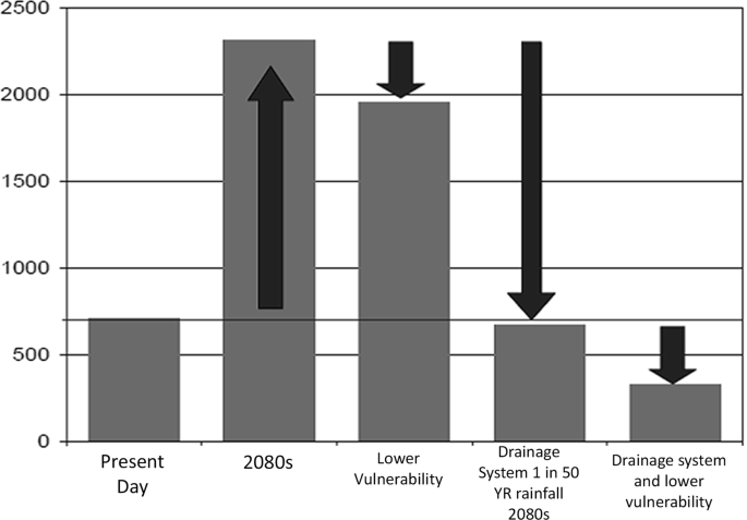
Estimated total losses for a 1-in-100-year flood events in Mumbai under five scenarios (following Hallegatte 2010)
Chennai, formerly known as Madras, was formed in 1600 and is the capital city of Tamil Nadu state. The city is located at the southern east coast of India, bounded by the Bay of Bengal in the east. The region has persistent as well as eventful archaeological and colonial history. The City is drained by three major rivers, namely Adyar (to the south), Cooum (through the centre) and Kosasthalaiyar (to the north). The city faces a number of risks which include climate-related as well as human-induced reasons (Gupta and Nair 2010). Chennai receives an average approximately 1300 mm of rainfall per year, but the majority of this (~ 800 mm) falls during the north-east (NE) monsoon months (October–December). The population of the city was 777,481 (1941 Census of India) before the independence of the country, which drastically increased thereafter to a current population of 10.16 million in 2016 (UNDESA 2016). This number is projected to continue increasing to 13.29 million in 2030. The rise in population leads to intensive developmental activities and land-use changes. The region has plain terrain, thus lacking a natural gradient for free run-off. In order to wade off a potential flood, the city requires natural buffering mechanisms such as wetlands, marshes and open lakes. These buffering factors are significantly affected by the construction and developmental activities allied to the city growth as well as encroachments. For example, the alarming decreases in the area of the Pallikaranai marshland from 5000 ha in 1970 to 988 ha in 2008 (Stephen 2016). Recent devastation by the flood waters in the region was wrought mainly by the shrinkage of wetlands and marshes. Major impacts of flooding on the booming IT industry in the region and sustainability of housing sector can be expected in the years to come (Suriya et al. 2012).
Kolkata, previously known as Calcutta, is the capital of the Indian state of West Bengal. Calcutta was the last of the port cities to be founded by the English, and the suburbanization had been started by the British during the last decades of the eighteenth century (Kosambi and Brush 1988). The modern city of Kolkata was developed on land recovered from the wetlands following the Dutch model of cities built along the Rhine River despite geographical challenge similar to those in Kolkata (Rumbach 2014). The city is often mentioned as the city in the swamps (Murphey 1964) and has been found to be one of the world’s most flood-prone coastal cities (Balica et al. 2012). Though situated away from the Bay of Bengal, the city is considered as a coastal city because of the deltaic setting. This megacity has a tropical climate and is subjected to extreme precipitation during monsoons with an annual rainfall of around 160 cm. It is situated on the bank of the Hooghly River and has an area of 1851 km2. The region is prone to flooding primarily due to the flat terrain and the drainage outfalls which are tide-dominated. Flooding occurs during excess rainfall on the catchment as well as during high-tidal conditions. The drainage sewer system in the city was designed during the British era and is not capable of handling the current run-off scenario. The sewer system also suffers from siltation and a consequent reduction in conveyance capacities irrespective of the efforts by the Kolkata Municipal Corporation (KMC) in renovating the drainage pipelines (Sen 2013). The population increase (14.98 million in 2016) (UNDESA 2016), rapid urbanization and the corresponding land-use changes have substantially reduced the flood-resilient efficacy of the region in recent years.
Research methods and comparative assessment
This section briefly provides insights into major flood events in the study regions and the different methodologies adopted in various studies for elucidating flood-induced risk in the above-mentioned coastal cities (Table 2).
Surat city
Flooding is common in the region which depends on climate, seasonality and other local factors. Five major flood events were reported since 1979, and the flood event of 2006 was devastating. Major flood events are reportedly caused due to monsoon-induced rainfall events (the peak flood is observed during August) (Agnihotri and Patel 2008) as well as by the emergency opening of the Ukai dam. The various factors which contribute to the flooding of Tapi River are the increase in population and allied factors such as built-up area increase, silting up of riverbed and embankment construction. Though the Ukai dam in the region was constructed with an additional aim to prevent floods, major floods during years 1998, 2004 and 2006 occurred due to the emergency opening of the dam when its capacity is overthrown (Joshi et al. 2012). The Khadi floods also pose a flooding threat (e.g. 2004, 2005 and 2007) in addition to the flooding of the Tapi River. Surat was selected as one of the pilot cities in the Asian cities climate resilience network in 2008. The major flood events also increase the risk of vector-borne disease in the region (Bhat et al. 2013). Jariwala and Samtani (2012) detailed the natural and anthropogenic cause of the flood in the southern part of Surat city, where the storm water is discharged through Mindhola River and its tributaries. Some of the anthropogenic factors listed are land reclamation on the bank of creeks, construction of bridges and suspended solids/non-degradable substances in city effluents. Natural reasons include precipitation pattern, catchment topography, bed gradients and the cross-sectional area available for flow. The peak flood is estimated from hydrological and catchment data using rational formula, and accordingly tributary cross sections were designed to contain the estimated peak flood. Jariwala and Samtani (2012) proposed the modification in the channel section of the most vulnerable stretches (Mithi and Kankara), so that it can contain peak flood waters. Joshi et al. (2012) had done urban flood mapping using geospatial techniques at Surat city. They used the Geo-Coded Indian Remote Sensing (IRS-1D) satellite image of April 2005 and Topo-Sheets at 1:50,000 scales collected from office of Survey of India and generated flood inundation map for the West Zone area of Surat City for different flood water levels. It was found that the inundation will start at water level above 4.0 m in the low-lying area in the West Zone area of Surat. The study also showed that the 95.38% area will be inundated when water level will rise at 12.0-m level.
A two-dimensional hydrodynamic model was used to simulate flooding (Ramirez and Rajasekar 2015). The methodology includes three stages: (1) simulation of Ukai dam release discharge reaching the city, (2) simulation of the combined effect of the tides and the dam released water, (3) delineating the vulnerable infrastructure and population. A loss and damage assessment of Surat City due to floods was carried out (Bahinipati et al. 2015). This study exclusively considered the textile industry which was affected during the 2006 floods. The storm drainage from the Surat city passes through various tributaries (creeks) and ultimately drains into the Mindhola River. Following the floods during 2006, flood hazards mapping of the urban floodplain of the Tapi catchment area was carried out using GIS and remote sensing techniques (Singh and Sharma 2009). Ukai dam release scenarios combined with tidal effects were used to run a two-dimensional flood model (CAESAR-Lisflood) using a fine spatial resolution (30 m) topography (Ramirez et al. 2016). Simulations were carried out for extreme conditions, and probabilistic flood risk maps were prepared for the city. The flood impact assessment and the extent of inundation in the low-lying area are carried out (Patel et al. 2017) using a 1D/2D coupled hydrodynamic model (HEC-RAS 5) considering two hundred and ninety-nine cross sections, five major bridges and two hydraulic structures along the river course. The model set-up considered the conditions (tidal level at the river mouth and the Ukai Dam release) during the 2006 flood as boundary conditions. The results indicated that ~ 75–77% area of the city was inundated during the flood. Areas within the city which are prone to flooding and submergence were identified using Digital Elevation Model and Geographical Information System (Patel and Dholakia 2010). Modelling studies incorporating climate factors are almost absent in the region. As the city is predicted to be prone to flooding induced by climate change impacts, there is a need for studies addressing this issue.
Mumbai city
The Mumbai region is prone to severe floods annually, and the flood of 2005 (Gupta 2007) was the worst in near history. The region is flood prone primarily due to its geography, which was shaped both by natural and by anthropogenic activities. The heavy summer monsoon rainfall together with the anthropogenic geographical alterations aggravates the flood risk. The land is heavily reclaimed and most of it is below the high-tide line, which can cause sea water entering to the complex drainage system of the city, resulting in mass inundation, as occurred during the 2005 floods. Urbanization is the most important driver of flood risk in the city. The inadequate drainage system and an ineffective spatial planning increase the flood risk in the region. There had been a surge in the number of studies regarding flood in the region following 2005 flood event. Major flood events in Mumbai are studied and compiled by Hallegatte et al. (2010). They used risk quantification following a standard catastrophe risk modelling framework combining estimates of hazard, exposure and vulnerability, which can give an estimate of economic damage and exposure of population to flood risks in various probabilities. Additional damages from the floods are also included in the framework. Simulation using climate model and further downscaling indicate high potential sensitivity of flood risk to climate change (Ranger et al. 2011). An urban flood model, Storm Water Management Model (SWMM), was used in the study. The land use/land cover (LULC) of the region is derived by analysing observations from the IRS LISS III satellite. Chatterjee (2010) discussed the response of the informal settlers in 2005 flood events in Mumbai. The study showed that informal settlers have to employ a combination of structural means and complex networks of assistance to recover from flood-induced risks. Ramesh et al. (2008) used extreme value analysis (EVA) to find out the hourly maximum rainfall, which is helpful in the estimation of flood levels during maximum rainfall conditions. The changes in the urban pattern (1973 and 2004) of the city were mapped using Landsat MSS and ETM+ data (Pavri 2010). A land-use map, using an unsupervised classification, and an elevation model using Shuttle Radar Topography Mission (SRTM) data were prepared, to identify the zones vulnerable to floods. A FEM-based flood simulation model was developed to simulate rainfall events consisting of flooding as well as non-flooding events (Shahapure et al. 2011). The model was integrated with the GIS and remote sensing database and could simulate the flooding event and the required detention pond. A Participatory Spatial Risks Mapping was carried out in the Dharavi region which encouraged the community participation which includes town watching and hazard mapping (Samaddar et al. 2011). The method was proved to be a very promising and empowering tool for local communities in tackling flood issues. An artificial neural network (ANN)-based flood management system was developed (Subramanian 2012), which helps users in data processing and can serve as an effective real-time flood tackling decision management system in the region due to its flexible and interactive nature. A methodology for rapid inundation mapping was developed for a data-sparse condition considering two scenarios (Gupta and Nikam 2013). The scenarios include continuous rainfall at 50 mm/h (the return period of 2 in 1 year) and 100 mm/h (the return period of 1 in 1 year), each for 1 h. This helped in delineating areas prone to flood water inundation due to these intensities. The flood simulation in the coastal urban region was carried out using an integrated flood assessment model in which the spatial data sets were organized by a web-based GIS framework (Kulkarni et al. 2014). The model could simulate the flood event during the extreme rainfall event of 2005. The spatial and temporal variation of LULC change for the coastal urban catchment area of the Mithi River was evaluated using toposheets and remote sensing data (Zope et al. 2015). Flood hydrographs were formulated for various conditions of LULC change and floodplain maps as well as flood hazard maps were derived. The models HEC-HMS and HEC-RAS were integrated with HEC-GeoHMS and HEC-GeoRAS for the preparation of maps. The study contends that major flooding can occur even in marginal flow conditions in the catchment when there is tidal influence. Another LULC change analysis was carried out for the Oshiwara River catchment in the region (Zope et al. 2016) to understand the impact of LULC change and urbanization on floods. The study found out an increase in the flood inundation area in the region.
Kolkata city
Kolkata city is prone to annual flooding during monsoon time and during extreme events such as cyclones. The city drainage network is too old, and the existing network is not sufficient for the entire city. The parts of the city were once wet lands, and the slope of the region as well as the wet land nature is posing threats to the drainage. A high-intensity rainfall event combined with high-tidal condition will always result in water-logging condition. Heavy siltation and inadequate maintenance of the sewer system have reduced the hydraulic capacity, which is also increasing the flood risks. The region is undergoing land subsidence (Chatterjee 2010), and this can be a boosting mechanism for future floods in the region. Presently, the population in the region has adapted to flood risks as it is not very severe and long lasting. Present adaptation strategies can change the wake of severe flood induced by climate change scenarios. There are three factors responsible for flood risks in the area: (1) natural factors, (2) developmental factor and (3) climate change factors. The natural factors include the low relief and topography, natural subsidence together with cyclones, storm surges and heavy rainfall. Unplanned urbanization, the low capacity drainage system, siltation in sewerage channels and human-induced subsidence are included in developmental factors (Dasgupta et al. 2013). The Kolkata Municipal Corporation (KMC) has recently introduced (September 2018) a comprehensive city-level Flood Forecasting and Early Warning System (FFEWS) making Kolkata as the first city in India having this kind of facility. This will empower the city administration and citizens in efficiently manage flood risks and damage.
An integrated management of storm water management in the region was discussed by Bose (2008). Remote Analysis of Vulnerability by Non-linearization Algorithm (RAVANA) was used to identify the extent of flood inundation in the Kolkata city (Chakraborty 2010). An array of automatic rain gauges and digital water-level sensors were used to monitor the rainfall distribution and water levels in the drainage channels in real time (Sen 2013). A framework for a real-time flood inundation forecasting model was proposed using a sewer flow–overland flow combined model, the results of which can be disseminated to the public through the internet. The flood vulnerability of the city was assessed considering intense precipitation events for return periods of 30, 50 and 100 years using rainfall data, emission scenarios and the sea-level rise for 2050 (Dasgupta et al. 2013). The outcome was a geographically overlaid, location-specific inundation depth and duration forecast. The study also projected the relevance of de-silting the sewers in reducing the vulnerability. The vulnerability of informal settlements in Kolkata to the flood risks indicates the dependence towards various socio-economic and infrastructure variables (Rumbach and Shirgaokar 2017). The study proposed that the disaster reduction policies should focus on lowest income groups. An open-source, coupled flood model having a surface model which uses a simplified numerical scheme and SWMM drainage network model was developed to study historical flooding in Kolkata (Courty 2018). The developed model has been proved to be a useful tool in flood risk mapping and drainage network design.
Chennai city
Chennai coastal region is prone to Tsunamis (e.g. in 2004) and cyclones; both the factors can cause coastal flooding. The flood in the region is manifested mainly by anthropogenic reasons (Drescher et al. 2007). Chennai lacks a natural gradient for free run-off; thus, an effective drainage system is very essential. The present drainage system is not sufficient for the growing city. The Cooum and Adyar rivers in the Chennai city also play a major role in the floods. The river banks are also heavily encroached. Chennai witnessed several catastrophic floods in recent years associated with heavy rainfall events and cyclonic depressions, which often lead to flooding of major rivers and clogging of the drainage system. A major flood event occurred in December 2015 and was reported as one of the most disastrous floods in the history of the region. The flood event affected 2 million people and caused the loss of properties worth US$ 80,000 million (Ramasamy et al. 2018). A surge in studies addressing the causes, effects and impacts of floods in the region was observed following the devastating flood of 2015.
Geocommunication and geovisualization were used as interactive participatory mapping tools to understand the risk due to extreme precipitation in the coastal areas of Chennai (Glaser et al. 2008), and the results were publically accessible through an information portal. Strategies to reduce flood risks were detailed in Gupta and Nair (2010, 2011), which include directions such as the protection of lakes and open water bodies from encroachment and eviction of existing encroachments by governmental agencies. Flood avoidance, flood tolerance and flood resilience strategies should be combined into an integrated mode to build up flood resistance in the city. A basin model was developed by using a hydrological model based on remote sensing (HEC-GeoHMS), and the run-off due to precipitation was simulated using the HEC-HMS model in the Thirusoolam sub-watershed in Chennai (Suriya and Mudgal 2012). Flood hazard and flood zone mapping were also carried out, and the study showed the impacts of urbanization on hydrological processes. Different available methods to tackle the damage caused by the flood and the methodology to assess the economic loss in the Velachery region, Chennai, were discussed by Suriya et al. (2012). The methods include problem identification tasks composed of focus group discussion, stakeholder meeting, the questionnaire survey, succeeded by the data set preparation and flood damage assessment. Soft systems methodology (Rich Picture Diagrams and CATWOE analysis) was used for an integrated flood management and assessment in Adyar watershed in Chennai (Suriya and Mudgal 2012). A vulnerability assessment study was carried out in the region using satellite data and GIS techniques. Shoreline change rates were derived, and the Chennai coastal region was classified as a highly vulnerable zone (Mariappan and Devi 2012). Pairwise ranking (ranking and prioritizing a decision criteria) and force field analysis (visual identification and analysis of the forces affecting the flood situation), which are participatory action research tools used, were also used. Hydrological (HEC-HMS) and Hydraulic (HEC-RAS) modelling was used in feasibility analysis to control the flooding (Gokilashree 2015). The study proposed a new drainage channel in south-west Chennai, which will reduce the inundation area by 70%. Some flood mitigation and prevention strategies such as the revival of Buckingham Canal and renovating the surface water bodies in the region were proposed (Selvaraj et al. 2016), in addition to the call for better strategies considering future extreme scenarios. Jameson and Baud 2016 showed the influence of a variety of knowledge about the flooding in creating a more efficient flood management system in Chennai. Meteosat IR rainfall data, measured using a multispectral rainfall signature-based rainfall estimation technique, were used to monitor the 2015 flood (Mishra 2016), and the 2015 flood scenario was analysed using an integrated geographical information system (GIS) and multicriteria decision analysis (MCDA) method (Seenirajan et al. 2017). Ahmed and Kranthi (2018) found that around 18% of the Chennai Metropolitan Area was affected by the 2015 flood event, using satellite data from Landsat-8 OLI, Sentinel-1 and CartoDEM-3 R1. Arabindoo (2016) discussed the argument among environmentalists and the administration where the former targeted the haphazard urbanization as a strong reason for the floods in the city and the later considered it as an unprecedented climate anomaly in the history of the city. Sharma et al. (2017) showed the potential of global rainfall products (Tropical Rainfall Measuring Mission (TRMM)) and global forecast precipitation products (Global Ensemble Forecast System (GEFS) in successful flood mapping of the region. Methods such as map and site analysis, focus group interview and questionnaire survey were employed by Muneerudeen (2017) to compose urban and landscape design strategies for flood resilience.
Climate change impacts and flood risks
There is a growing scientific consensus that the climate is changing (Hartter et al. 2018), and the impacts on the coastal zone can be in the form of sea-level rise, the increase in the frequency of extreme wind events, the change of the annual frequency of winds, the increase in storm surge events frequency, higher waves, changes in wave direction and changes in coastal currents (Karambas 2015). These impacts can result in urban flooding events of varying intensities ultimately affecting the prevailing city metabolism. The impacts of the changing climate are exacerbated in urban areas due to the immense anthropogenic activities centred around these regions. All the cities addressed in this study have been through recent flood problems related to the changing climate. There are less studies addressing the climate change impacts on the flood events in these urban areas, and there is a knowledge gap regarding these realms.
For Surat city, various climatic factors, such as precipitation, temperature and sea level, were identified in the region which increase the flood risks and can induce coastal inundation. Climate models also indicate higher future precipitation in the region and an increase in number of rainy days. The models also predict the increase in minimum and maximum temperature of the region with a monthly average maximum temperature increase by 0.5 °C (Bhat et al. 2013). A Climate Change Impact Assessment using HEC-RAS model was carried out to picturize the inundation scenario in Surat (Parikh et al. 2017). A hypothetical situation was considered (a 50% increase in water inflow in the Tapi River) as a possible impact of climate change. The results indicated that there will be more inundated areas in the region as a result of climate change impacts.
For the city of Mumbai, previous studies indicate that the region is likely to be highly vulnerable to climate change and that the flood-prone and reclaimed land is occupied by the majority of Mumbai population (Patankar et al. 2010). The city is vulnerable and exposed to climate change-induced hazards stemming from sea-level rise, heavy precipitation, storm surge and tropical cyclone risks (Hallegatte et al. 2010). An assessment of climate change impacts in the region observed that by 2080 the likelihood of floods similar to the 2005 flood is more than double (Ranger et al. 2011). The climate change-induced floods can also inflict current and future economic losses in the region (Kumar et al. 2008), and the cost was found to be enormous. The single-value water surface method was used to find out the probable flooding for the various sea-level rise scenarios, and it is observed that the rate of coastal inundation is directly correlated with the sea-level rise (Singh and Kambekar 2017). Climate change-induced sea-level rise scenarios were used to study (Pramanik 2017) the impacts caused by these scenarios on the Mumbai coastal region and concluded that the sea-level rise can potentially reduce the drainage gradients in the city and can induce flooding conditions.
For Kolkata city, climate change factors responsible for flooding in the region comprises the sea-level rise, extreme precipitation and storm surge. Increased flooding in the region is caused by increased precipitation together with high tide and extreme storm surge. Dasgupta et al. (2013) studied the hydrological and hydraulic impacts of extreme precipitation due to climate change by 2050. The study employed three models to capture the flooding: (1) Soil and Water Assessment Tool (SWAT) (hydrological model), (2) Hydrologic Engineering Centre-River Analysis System (HEC-RAS) (hydraulic model) and (3) Storm Water Management Model (SWMM) (urban storm model), and historical rainfall data from continuous recording rain gauges for 25 years. The study urges the need for considering the climate change effects in all the future adaptation strategies for the Kolkata city. The heavy rainfall and storm surge combined with the high-tide result is heavy flooding and is a major problem for the river-side dwellers of the city (Ghosh 2015), which will be exacerbated in this era of climate change, and a world bank study modelled the impact of climate change on increased flooding in the region (World Bank 2011).
For Chennai city, there is a knowledge gap in the climate change assessment of the Chennai city since there are no major assessment studies till date. It is high time to address climate change impacts on flood risks and associated variability in the wake of present regional as well as global climate scenarios. van Oldenborgh et al. (2016) ruled out the possibility of the effect of global warming during the extreme rainfall event (caused by substantial flooding and inundation) of December 2015. This was attributed to the counteracting effect of aerosols and greenhouse gases. Some of the recent case studies about Chennai floods of December 2015 investigated the impact of climate change based on extreme rainfall data and the relationship with the global phenomenon like El-Nino and La-Nina, but the observations are contrary because of different data sets and methodologies for analysis (Krishnamurthy et al. 2018; Boyaj et al. 2018).
Flood risk and impacts on the cultural sites and monuments
The flood risks and impacts on the heritage sites and monuments in the coastal cities are a less addressed issue globally. A large number of cultural world heritage sites are concentrated near the coasts (Marzeion and Levermann 2008). Currently, there are lot of instances regarding disasters affecting the cultural heritage and monuments, but this realization is still not widespread (Taboroff 2003). The cultural heritage and monuments in historical urban areas have not received attention or support they warrant (Jigyasu 2016). The integration of cultural heritage and development in urban areas can result in a substantial increase in the sustainability and diversity of proposed development. This can also provide opportunities for employment and community participation ensuing social cohesion and peace (ICOMOS 2015). A holistic approach should be undertaken for the flood risk assessment in regions with cultural heritage structures, which must integrate physical, economic, social, and cultural vulnerabilities, along with perceived risk (Vojinovic et al. 2016). Cultural sites, historical infrastructure, monuments and objects of art can be affected by a wide variety of flood-associated impacts (Drdácký 2010). These include horizontal static pressure of the rising water, upward hydrostatic pressure, floating and displacement of objects due to the low-velocity stream movement, dynamic high-velocity stream action due to high-pressure water emerging through tiny openings, dynamic impacts of floating materials, the dynamic wave impacts, changes in soil properties and condition, saturation of objects and materials with water as a result of complete immersion in water, chemical and biological pollutants affecting historical objects and art works, barrier formation by the floating objects due to the combined uplift forces and flow, and post-flood effects such as change in internal climate resulting from high humidity, and appearance of cracks, the loss of cohesion, and volumetric changes of structures and materials due to the post-flood drying. There are several occasions of destruction of the archaeological sites and monuments due to flood effects even in the countries which devised substantially well and practical adaptation strategies to cope up with the flood damage inflicted to cultural sites and monuments. All the four cities addressed in this work are historical cities and have a significant place in global history. Currently, there is no authenticated database showing the extent of damage to the cultural sites and monuments in these cities due to past floods. Due to the absence of any ample legal framework, the vulnerability of the historical urban areas has been exacerbated during the disaster as well as the emergency period and post-disaster recovery phases (Jigyasu 2016). The recently released National Disaster Management Guidelines for Cultural Heritage Sites and Precincts (NDMA 2017) contain sufficient details pertaining to the directions for various departments, ministries and other stakeholders involved in the management of Cultural Heritage Sites and Precincts. These guidelines, if followed properly and systematically, can be very useful for the historical urban areas in India where there is recurring floods and associated impacts.
Adaptation framework for managing flood risks
Adaptation to extreme events such as coastal floods is very crucial in the present era due to the multi-facet nature of the causes and effects, which will be exacerbated due to the increasing population and climate change. The ever-changing and cross-boundary nature of flood risk (Jongman 2018) render adaptation strategies as very crucial in this era of fluctuating social and environmental conditions. Flood adaptation strategies are often intended to minimize impacts on various sectors such as built environment, human health, water quality and transport infrastructures (Wilby and Keenan 2012). The efficient and effective adaptation strategies should have the services of structures and facilities to defend flood, use solutions which are nature-based, have early warning systems, include financing schemes to tackle and reduce the economic loss due to the flood risk, practice risk-informed land planning (Jongman 2018). The regions located mainly in the tropics will experience the largest increase in the flooding frequency in the near future (Vitousek et al. 2017). Human adaptation to the environment is one of the most important processes of survival (Rossnerova et al. 2017) in the era of extreme floods. Adaptation measures in a developing country like India can bring in immediate community benefits (Mathew et al. 2012) which can result in the reduction in future flood impacts. Though there is a considerable improvement in the flood adaptation measures in India, the social and economic costs due to floods continue to increase yearly. Adaptation measures can play a pivotal role in managing flood risks in the near future in the four coastal cities addressed in this study, considering the huge population and infrastructure which are vulnerable to extreme flood conditions.
Agnihotri and Patel (2008) elucidated flood reduction plans for the Surat city by suggesting some preventive and curative measures by highlighting the need for flood water detention ponds and diversion of flood waters to other rivers. They used Kennedy’s theory for the design of the interlinking canals. A channel modification strategy for the Tapi River using HEC-RAS and Arc GIS software HECGeo was put forwarded (Agnihotri and Patel 2011) as a curative flood control measure, useful in the preparation of mitigation and adaptations plans. Bhat et al. (2013) addressed various strategies to aid Surat city to cope up with and adapt to flood risks. Flood adaptation uses built environment such as by raising the plinth height and urging to use the ground floor for parking purposes only. Low-income groups adopt their own methods to store valuables in the case of extreme events, for example keeping things in plastic pouches. Warnings using the help of information technology are also included in adaptation strategies. The megaphone warning mostly helps the low-income group during a possible flood event. There are plans to implement GIS-assisted warning system by geotagging residential complexes and collecting the information of vulnerable people (elderly, infirm, babies, pregnant women) during pre-monsoon time. Using qualitative interviews and public planning documents, Patel (2014) addressed adaptation strategies in the Surat city. The major flood event of 2006 and its after-effects paved the way for increased public consciousness of flood risk and need for adaptation strategies, leading to major investments by the public and private sector players in adaptation strategies and methods. Micro-level approaches for prevention and response protocol at ward level in addition to city level were also implemented specially for flood risk. Over the years, Surat city has acquired successful adaptation and resilience strategies to deal with extreme events. The ever-changing environmental conditions are a challenge to the city and thus warrant further studies regarding adaptation strategies considering future scenarios.
In Mumbai, more than half of the population live in squatter settlements, rendering this low-income group more vulnerable to the perils of the recurring floods. There was always an inertia in response by the authorities towards extreme events in the city (Johnson et al. 2015), which was well reflected in the 2005 Mumbai flood. The devastating flood leads to the constitution of a fact finding committee to find out the causes for the disaster and to take measures. In order to reduce future risks, the government also initiated the Mithi river bed restoration plan. The river is choked with plastic wastes and is devoid of a floodplain because of the encroachment and the illegal settlements. Due to this, the slightest unforeseen rainfall can cause flooding in the region (Vengurlekar and Patkar 2016). A public participatory workshop method called Yonmenkaigi System Method (YSM) was implemented in the Mumbai region, which imbibe the concerns and dimensions of the problems based on the perspective of the community (Samaddar et al. 2015). The method will enable the community to assess their strengths and weaknesses rather than depending on other supports, such as from civic bodies, for tackling and adapting to the flood-related problems. The adaptation strategies in the Mumbai region should identify the physical, economic and social vulnerability of the areas with poor and low-income households, small businesses and informal settlements, and adaptation should be incorporated as a main component into larger developmental goals (Patankar and Patwardhan 2016). Surjan and Shaw (2009) analysed the role of participatory mechanism called ALM (Advanced Locality Management) in flood risk reduction. ALM has enabled people to care the environment beyond their own household and work for the entire locality. The local government also encouraged this community effort since it reduces flood risks as well as the burden on overstressed municipal activities, which further helps in reducing water-borne diseases and epidemics in the region. These types of people or community-centred activities with the support of government can play a major role in the reduction in disaster hazard risks. Based on the data collected from informal settlements in Mumbai, Chatterjee (2010) showed different adaptation strategies taken by the population occupying these settlements. These include structural adjustments, support networks after the flood event and networks of loss redistribution. Considering the informal settlements, Subramanyam and MacAlister (2016) elaborated the prevailing gap in the perception of solutions to flooding risks between the community and local government. Micro-Small and Medium Enterprises (MSMEs), which are some of the most affected establishments during flood events, in the flood-affected areas implemented their own flood protection measures which include various structural and non-structural measures (Schaer and Pantakar 2018).
Kolkata’s seasonal flooding has prompted the local population to adapt a number of management strategies. However, challenges are still continuing due to the adaptation deficit in (1) sewer network, (2) drainage infrastructure and (3) financial resources. Some recommended adaptive measures are de-siltation of the existing main sewer, construction of new main sewers, extension of the drainage facility, improvement in the storm water drainage system and renovation of the outfall canal system (Dasgupta et al. 2013). A substantial transition in risk governance is observed in the region in recent times, and the flood risks are managed more efficiently and in a responsive mode (Parasuram et al. 2016). For example, pumps are deployed immediately after heavy rainfall events to drain the flood water.
In Chennai, urbanization coupled with climate variability turned out as a prominent reason for flood-induced risks, which was well reflected in the recent 2015 flood events. An integrated approach is essential to avert the vagaries of extreme flood events. This approach should combine watershed and land-use management with planning of development, engineering precautions, flood preparedness and emergency management in affected areas (Lavanya 2012). Local adaptation strategies are essential to bring about flood resilience in the region (Tajuddin 2018), by constructing socio-ecological resilience at the neighbourhood level. Geotagging and text mining techniques were used to understand the resilience of infrastructure using 2015 flood data (Chong et al. 2018), and social media is found to be very useful in evaluating the infrastructure resiliency (Yadav and Rahman 2016; Gunessee et al. 2017) and flood adaptation (Nair et al. 2017). Locality-specific, culturally relevant green social work which was implemented in the region proved to be a better adaptation strategy to tackle the flood risks (Samuel et al. 2018).
Concluding remarks
This study briefly reviewed the flood risk and adaptation assessment studies in major Indian coastal cities. Four coastal cities (Surat, Mumbai, Chennai and Kolkata) were selected based on the flood risks, anthropogenic activities and vulnerability from flood hazards. This review study also identified some knowledge gaps in flood risk assessment and allied studies in Indian coastal cities. Among the four cities, Mumbai followed by Surat is most vulnerable in terms of flood risks associated with anthropogenic activities. Another factor which exacerbates flood risk in all these cities is the lack of proper drainage and sewerage system. Community-based adaptation strategies in grassroots level supported by local governments show some successes in adaptation for tackling flood risk scenarios in urban areas. Economic minorities are mostly affected by flood risk and associated problems in these cities. Future planning and management of flood risks in these cities should also include economic minorities for the sustainability of city environments. Early warning systems combined with information technology should be effectively implemented in flood risk management and adaptation strategies to make the strategies more effective and practical. Though this review has a drawback that only four cities were considered, the study can be representative of other Indian coastal cities which have similar trends in environmental and demographic settings.
References
Agnihotri PG, Patel JN (2008) Study of flood at Surat City and its remedial measures the 3rd IASME. In: WSEAS international conference on water resources, hydraulics and hydrology, vol 3, pp 23–25
Agnihotri PG, Patel JN (2011) Improving carrying capacity of River Tapi (Surat, India) by channel modification. Int J Adv Eng Technol 2:231–238
Ahmed CF, Kranthi N (2018) Flood vulnerability assessment using geospatial techniques: Chennai, India. Indian J Sci Technol 11(6):1–13
Arabindoo P (2016) Unprecedented natures? An anatomy of the Chennai floods. City 20(6):800–821
Bahinipati CS, Rajasekar U, Acharya A, Patel M (2015) Flood-induced economic loss and damage to the textile industry in Surat City, India. Asian Cities climate resilience working paper series 26
Bai X, Dawson RJ, Ürge-Vorsatz D et al (2018) Six research priorities for cities and climate change. Nature 555:23–25. https://doi.org/10.1038/d41586-018-02409-z
Balica SF, Wright NG, van der Meulen F (2012) A flood vulnerability index for coastal cities and its use in assessing climate change impacts. Nat Hazards 64:73–105
Bhat GK, Karanth A, Dashora L, Rajasekar U (2013) Addressing flooding in the city of Surat beyond its boundaries. Environ Urban 25:1–13
Bose S (2008) Adaptive and integrated management of wastewater and storm water drainage in Kolkata—case study of a Mega City. In: Pahl Wostl C, Kabat P, Moltgen J (eds) Adaptive and integrated water management: coping with complexity and uncertainty. Springer, Heidelberg, New York, Berlin, pp 341–355
Boyaj A, Ashok K, Ghosh S, Devanand A, Dandu G (2018) The Chennai extreme rainfall event in 2015: the Bay of Bengal connection. Clim Dynam 50(7–8):2867–2879
Chakraborty T (2010) Flood inundation study of Kolkata Metro City with remote analysis of vulnerability by non-linearization algorithm (RAVANA). Doctoral dissertation, Jadavpur University
Chatterjee M (2010) Slum dwellers response to flooding events in the megacities of India. Mitig Adapt Strateg Glob Change 15:337–353
Chong WK, Naganathan H, Liu H, Ariaratnam S, Kim J (2018) Understanding infrastructure resiliency in Chennai, India using Twitter’s Geotags and texts: a preliminary study. Engineering 4(2):218–223
Courty L (2018) Integrated modelling of overland flows and drainage networks in an urban environment. Thesis
Creel L (2003) Ripple effects: population and coastal regions. Population Reference Bureau, Washington, DC
Cross JA (2001) Megacities and small towns: different perspectives on hazard vulnerability. Gob Environ Change 3:63–80
Da Cunha, Jose G (1902) The origin of Bombay (Vol. 20). Society’s library
Dasgupta S, Gosain AK, Rao S, Roy S, Sarraf M (2013) A megacity in a changing climate: the case of Kolkata. Clim Change 116:747–766
de Oliveira JAP, Doll CN (2016) Governance and networks for health co-benefits of climate change mitigation: lessons from two Indian cities. Environ Int 97:146–154
Drdácký MF (2010) Flood damage to historic buildings and structures. J Perform Constr Fac 24(5):439–445
Drescher A, Glaser R, Pfeiffer C, Vencatesan J, Schliermann-Kraus E, Glaser S, Dostal P (2007) Risk assessment of extreme precipitation in the coastal areas of Chennai as an element of catastrophe prevention. In: Forum DKKV/CEDIM: disaster reduction in climate change
Füssel HM, Klein RJ (2006) Climate change vulnerability assessments: an evolution of conceptual thinking. Clim Change 75:301–329
Ghosh A (2015) Kolkata and climate change. Clim Change Policy Pap IV WWF 4:1–20
Glaser S, Glaser R, Drescher A, Pfeiffer C, Schliermann-Kraus E, Lechner M, Vencatesan J (2008) Geo-communication for risk assessment and catastrophe prevention of flood events in the coastal areas of Chennai. In: Sànchez-Marrè M, Béjar J, Comas J, Rizzoli A (eds) iEMSs 2008: International Congress on Environmental Modelling and Software Integrating Sciences and Information Technology for Environmental Assessment and Decision Making 4th Biennial Meeting of iEMSs. International Environmental Modelling and Software Society
Gokilashree R (2015) A feasibility analysis on new drainage channel to control flooding in Southwest Chennai using hydraulic model. J Water Resour Eng Manag 2(1):1–7
Gunessee S, Subramanian N, Roscoe S, Ramanathan J (2017) The social preferences of local citizens and spontaneous volunteerism during disaster relief operations. Int J Prod Res 16:1–6
Gupta V (1987) Tourism in India. Gyan Publishing House, New Delhi
Gupta K (2007) Urban flood resilience planning and management and lessons for the future: a case study of Mumbai, India. Urban Water J 4(3):183–194
Gupta AK (2009) Urban floods: case study of Mumbai. Disaster Dev 3(2):99
Gupta AK, Nair SS (2010) Flood risk and context of land-uses: Chennai city case. J Geogr Reg Plan 3:365–372
Gupta AK, Nair SS (2011) Urban floods in Bangalore and Chennai: risk management challenges and lessons for sustainable urban ecology. Curr Sci 10:1638–1645
Gupta K, Nikam V (2013) A methodology for rapid inundation mapping for a megacity with sparse data: case of Mumbai, India. IAHS-AISH publication 385-391
Hallegatte S et al (2010) Flood risks, climate change impacts and adaptation benefits in Mumbai: an initial assessment of socio-economic consequences of present and climate change induced flood risks and of possible adaptation options. OECD environment working papers, no. 27. OECD Publishing
Hartter J, Hamilton LC, Boag AE, Stevens FR, Ducey MJ, Christoffersen ND, Oester PT, Palace MW (2018) Does it matter if people think climate change is human caused? Clim Serv 10:53–62
Hunt A, Watkiss P (2011) Climate change impacts and adaptation in cities: a review of the literature. Clim Change 104:13–49
ICOMOS (2015) Cultural heritage, the UN sustainable development goals, and the new urban agenda. In: ICOMOS concept note for the United Nations post-2015 agenda and the third United Nations conference on housing and sustainable urban development (HABITAT III)
IYB (2007) India year book. Government of India, New Delhi
Jaiswal N, Kishtawal CM, Bhomia S (2018) Similarity-based multi-model ensemble approach for 1–15-day advance prediction of monsoon rainfall over India. Theor Appl Climatol 132:639–645. https://doi.org/10.1007/s00704-017-2109-6
Jameson S, Baud IS (2016) Varieties of knowledge for assembling an urban flood management governance configuration in Chennai, India. Habitat Int 54:112–123
Jariwala RC, Samtani BK (2012) The estimation of flood and its control by section modification in Mithi and Kankara tributaries at Surat. Int J Eng Res Appl 2:862–867
Jigyasu R (2016) Reducing disaster risks to urban cultural heritage: global challenges and opportunities. J Herit Manag 1(1):59–67
Joerin J, Shaw R, Takeuchi Y, Krishnamurthy R (2012) Assessing community resilience to climate-related disasters in Chennai, India. Int J Disaster Risk Reduct 1:44–54
Johnson C, Toly N, Schroeder H (eds) (2015) The urban climate challenge: rethinking the role of cities in the global climate regime. Routledge, London
Jongman B (2018) Effective adaptation to rising flood risk. Nat Commun 9(1):1986
Joshi PM, Sherasia NK, Patel DP (2012) Urban flood mapping by geospatial technique a case study of Surat City. IOSR J. Eng 2:43–51
Kale VS, Ely LL, Enzel Y, Baker VR (1996) Palaeo and historical flood hydrology, Indian Peninsula. Geol Soc Lond Spec Publ 115:155–163. https://doi.org/10.1144/GSL.SP.1996.115.01.12
Karambas TV (2015) Modelling of climate change impacts on coastal flooding/erosion, ports and coastal defence structures. Desalin Water Treat 54(8):2130–2137
Kosambi M, Brush JE (1988) Three colonial port cities in India. Geograph Rev 78(1):32–47
Krishnamurthy L, Vecchi GA, Yang X, van der Wiel K, Balaji V, Kapnick SB, Underwood S (2018) Causes and probability of occurrence of extreme precipitation events like Chennai 2015. J Clim 31(10):3831–3848
Kulkarni AT, Mohanty J, Eldho TI, Rao EP, Mohan BK (2014) A web GIS based integrated flood assessment modeling tool for coastal urban watersheds. Comput Geosci 64:7–14
Kumar R, Jawale P, Tandon S (2008) Economic impact of climate change on Mumbai, India. Reg Health Forum 12:38–42
Lavanya AK (2012) Urban flood management—a case study of Chennai City. Archit Res 2:115–121
Lindley SJ, Handley JF, Theuray N, Peet E, McEvoy D (2006) Adaptation strategies for climate change in the urban environment: assessing climate change related risk in UK urban areas. J Risk Res 9:543–568
Mahmood S, Davie J, Jermey P et al (2018) Indian monsoon data assimilation and analysis regional reanalysis: configuration and performance. Atmos Sci Lett 19:3. https://doi.org/10.1002/asl.808
Mariappan VN, Devi RS (2012) Chennai coast vulnerability assessment using optical satellite data and GIS techniques. Int J Remote Sens 1:175–182
Marzeion B, Levermann A (2008) Loss of cultural world heritage and currently inhabited places to sea-level rise. Environ Res Lett 9(3):034001
Mathew S, Trück S, Henderson-Sellers A (2012) Kochi, India case study of climate adaptation to floods: ranking local government investment options. Glob Environ Change 22(1):308–319
MCGM (2014) Greater Mumbai city development plan 2005–2025. Municipal Corporation of Greater Mumbai, Mumbai
Mendelsohn R, Emanuel K, Chonabayashi S, Bakkensen L (2012) The impact of climate change on global tropical cyclone damage. Nat Clim Change 2(3):205
Mishra AK (2016) Monitoring Tamil Nadu flood of 2015 using satellite remote sensing. Nat Hazards 82(2):1431–1434
Muneerudeen A (2017) Urban and landscape design strategies for flood resilience in Chennai city. Master’s thesis
Murphey R (1964) The city in the swamp: aspects of the site and early growth of Calcutta. Geogr J 130:241–256
Nair MR, Ramya GR, Sivakumar PB (2017) Usage and analysis of Twitter during 2015 Chennai flood towards disaster management. Procedia Comput Sci 115:350–358
NDMA (2017) National disaster management guidelines for cultural heritage sites and precincts, September 2017. New Delhi A publication of the National Disaster Management Authority, Government of India
Nicholls RJ, Small C (2002) Improved estimates of coastal population and exposure to hazards released. Eos 83:301–305
Nicholls RJ et al (2008) Ranking port cities with high exposure and vulnerability to climate extremes: exposure estimates. OECD environment working papers, no. 1. OECD Publishing
Pacione M (2006) City profile Mumbai. Cities 23:229–238
Parasuram P, Narayanan P, Pelling M, Solecki W, Ramachandran P, Ramachandran R (2016) Climate change adaptation pathways in Kolkata. J Extreme Events 3(03):1–22
Parikh K, Parikh J, Kumar M (2017) Vulnerability of Surat, Gujarat to flooding from Tapi River: a climate change impact assessment. Vayu Mandal 43(2):120–129
Patankar A, Patwardhan A (2016) Estimating the uninsured losses due to extreme weather events and implications for informal sector vulnerability: a case study of Mumbai, India. Nat Hazards 80(1):285–310
Patankar A, Patwardhan A, Andharia J, Lakhani V (2010) Mumbai city report. In: International workshop on climate change vulnerability assessment and urban development planning for Asian coastal cities
Patel T (2014) Funding for adaptation to climate change: the case of Surat. Doctoral dissertation, Massachusetts Institute of Technology
Patel DP, Dholakia MB (2010) Identifying probable submergence area of Surat City using digital elevation model and geographical information system. World Appl Sci J 9(4):461–466
Patel DP, Ramirez JA, Srivastava PK et al (2017) Assessment of flood inundation mapping of Surat city by coupled 1D/2D hydrodynamic modeling: a case application of the new HEC-RAS 5. Nat Hazards 89:93–130. https://doi.org/10.1007/s11069-017-2956-6
Pavri F (2010) Urban expansion and sea-level rise related flood vulnerability for Mumbai (Bombay), India using remotely sensed data. In: Showalter P, Lu Y (eds) Geospatial techniques in urban hazard and disaster analysis. Springer, Dordrecht, pp 31–49
Pramanik MK (2017) Impacts of predicted sea level rise on land use/land cover categories of the adjacent coastal areas of Mumbai megacity, India. Environ Dev Sustain 19(4):1343–1366
Rahmstorf S (2017) Rising hazard of storm-surge flooding. Proc Natl Acad Sci 114(45):11806–11808
Ramasamy SM, Vijay A, Dhinesh S (2018) Geo-anthropogenic aberrations and Chennai floods: 2015, India. Nat Hazards 92(1):443–477
Ramesh C, Vivekanandan N, Surwade KB, Bapat AD, Govindan S, Mathew FT (2008) Extreme value analysis of rainfall in Mumbai region to aid estimation of severe flood. ISH J Hydraul Eng 14(2):102–117
Ramirez J, Rajasekar U (2015) Modelling flood impact in Surat, India. In: TIFAC-IDRiM conference, New Delhi, India
Ramirez J, Rajasekar U, Coulthard T, Keiler M (2016) Probabilistic mapping of urban flood risk: application to extreme events in Surat, India. In: EGU general assembly conference abstracts, vol 18, p 2093
Ranger N, Hallegatte S, Bhattacharya S, Bachu M, Priya S, Dhore K, Corfee-Morlot J (2011) An assessment of the potential impact of climate change on flood risk in Mumbai. Clim Change 104:139–167
Rawlinson HG (1920) British beginnings in Western India, 1579–1657: an account of the early days of the British factory of Surat. Clarendon Press, Oxford
Revi A (2008) Climate change risk: an adaptation and mitigation agenda for Indian cities. Environ Urban 20:207–229
Rodriguez JA, Fernandez FJ, Arboleya P (2018) Study of the architecture of a smart city. Proceedings 2(23):1485
Rossnerova A, Pokorna M, Svecova V, Sram RJ, Topinka J, Zölzer F, Rossner P (2017) Adaptation of the human population to the environment: current knowledge, clues from Czech cytogenetic and “omics” biomonitoring studies and possible mechanisms. Mutat Res Rev Mutat 773:188–203
Rumbach A (2014) Do new towns increase disaster risk? Evidence from Kolkata, India. Habitat Int 43:117–124
Rumbach A, Shirgaokar M (2017) Predictors of household exposure to monsoon rain hazards in informal settlements. Nat Hazards 85(2):709–728
Samaddar S, Chatterjee R, Misra BA, Tatano H (2011) Participatory risk mapping for identifying spatial risks in flood prone slum areas, Mumbai. Annu Disaster Prev Res Inst Kyoto Univ 54B
Samaddar S, Choi J, Misra BA, Tatano H (2015) Insights on social learning and collaborative action plan development for disaster risk reduction: practicing Yonmenkaigi system method (YSM) in flood-prone Mumbai. Nat Hazards 75(2):1531–1554
Samuel M, Annadurai P, Sankarakrishnan S (2018) The 2015 Chennai floods: green social work, an emerging model for practice in India. The Routledge handbook of green social work, pp 281–292
Schaer C, Pantakar A (2018) Promoting private sector engagement in climate change adaptation and flood resilience—a case study of innovative approaches applied by MSMEs in Mumbai, India. In: Alves F, Leal Filho W, Azeiteiro U (eds) Theory and practice of climate adaptation. Springer, pp 175–191
Schaer C, Bee S, Kuruppu N (2018) Developing the business case for adaptation in agriculture: case studies from the adaptation mitigation readiness project. Private-sector action in adaptation: perspectives on the role of micro, small and medium size enterprises, p 51
Seenirajan M, Natarajan M, Thangaraj R, Bagyaraj M (2017) Study and analysis of Chennai flood 2015 using GIS and multicriteria technique. J Geogr Inf Syst 9(02):126
Sekovski I, Newton A, Dennison WC (2012) Megacities in the coastal zone: using a driver-pressure-state-impact-response framework to address complex environmental problems. Estuar Coast Shelf Sci 96:48–59
Selvaraj K, Pandiyan J, Yoganandan V, Agoramoorthy G (2016) India contemplates climate change concerns after floods ravaged the coastal city of Chennai. Ocean Coast Manage 129:10–14
Sen D (2013) Real-time rainfall monitoring and flood inundation forecasting for the city of Kolkata. ISH J Hydraul Eng 19(2):137–144
Shahapure SS, Eldho TI, Rao EP (2011) Flood simulation in an urban catchment of Navi Mumbai City with detention pond and tidal effects using FEM, GIS, and remote sensing. J Waterw Port Coast Ocean Eng 137:286–299
Shahi NK, Rai S, Mishra N (2018) Recent predictors of Indian summer monsoon based on Indian and Pacific Ocean SST. Meteorol Atmos Phys. https://doi.org/10.1007/s00703-018-0585-6
Sharma VK, Mishra N, Shukla AK, Yadav A, Rao GS, Bhanumurthy V (2017) Satellite data planning for flood mapping activities based on high rainfall events generated using TRMM, GEFS and disaster news. Ann GIS 23(2):131–140
Singh PD, Kambekar AR (2017) Assessing impact of sea level rise along the coastline of Mumbai City using geographic information system. In: Seta F, Biswas A, Khare A, Sen J (eds) Understanding built environment. Springer, pp 87–96
Singh AK, Sharma AK (2009) GIS and a remote sensing-based approach for urban flood-plain mapping for the Tapi catchment, vol 331. IAHS Publication, Wallingford, p 389
Small C, Nicholls RJ (2003) A global analysis of human settlement in coastal zones. J Coast Res 19:584–599
SMC (2011) Surat City resilience strategy. Surat Municipal Corporation, Surat
Solecki W, Rosenzweig C, Dhakal S et al (2018) City transformations in a 1.5 °C warmer world. Nat Clim Change 8:177–181
Stephen A (2016) Natural disasters: Are they really natural? In: Proceedings of ICSSR sponsored national seminar on infrastructural development and environment: issues and challenges
Subramanian R (2012) Implementation of neural networks in flood forecasting. Int J Sci Res Publ 2(10):1–3
Subramanyam N, MacAlister C (2016) Governance of flooding risks in informal settlements in satellite cities in the Mumbai region. South Asian Water Stud 6(1):12–27
Suriya S, Mudgal BV (2012) Impact of urbanization on flooding: the Thirusoolam sub watershed—a case study. J Hydrol 412:210–219
Suriya S, Mudgal BV, Nelliyat P (2012) Flood damage assessment of an urban area in Chennai, India, part I: methodology. Nat Hazards 62:149–167
Surjan A, Shaw R (2009) Enhancing disaster resilience through local environment management: case of Mumbai, India. Disaster Prev Manage 18:418–433
Taboroff J (2003) Natural disasters and urban cultural heritage: a reassessment. In: Kreimer A, Arnold M, Carlin A (eds) Building safer cities: the future of disaster risk. The World Bank, Disaster Risk Management, Series no. 3, 2003, pp. 233–240
Tajuddin N (2018) Leveraging socio-cultural networks: local adaptation strategies to bring about flood resilience in Chennai metropolitan area, India. Thesis TU Delft Architecture and the Built Environment
UN (2008) Urban agglomerations 2007. United Nations Department of Economic and Social Affairs, Population Division, New York
UNDESA (2016) The world’s cities in 2016. United Nations, Department of Economic and Social Affairs, Population Division, New York, p 392
UNESCO (2009) World water assessment programme (United Nations). Water in a changing world. UNESCO, Paris
Ürge-Vorsatz D, Rosenzweig C, Dawson RJ et al (2018) Locking in positive climate responses in cities. Nat Clim Change 8:174–177
Van Oldenborgh GJ, Otto FE, Haustein K, AchutaRao K (2016) The heavy precipitation event of December 2015 in Chennai, India. Bull Am Meteorol Soc 97(12):87–91
Vaz E (2014) Managing urban coastal areas through landscape metrics: an assessment of Mumbai’s mangrove system. Ocean Coast Manage 98:27–37
Vengurlekar M, Patkar S (2016) Mithi river regeneration. International Journal of Research in Advent Technology, Special Issue RDACE, March 2016, 90–96, Special Issue National Conference VishwaCon’16, 19 March 2016
VishnuRadhan R, Vethamony P, Zainudin Z, Kumar KV (2014) Waste assimilative capacity of coastal waters along Mumbai Mega City, West Coast of India using MIKE-21 and WASP simulation models. CLEAN 42:295–305
Vitousek S, Barnard PL, Fletcher CH et al (2017) Doubling of coastal flooding frequency within decades due to sea-level rise. Sci Rep 7:1399
Vojinovic Z, Hammond M, Golub D, Hirunsalee S, Weesakul S, Meesuk V, Medina N, Sanchez A, Kumara S, Abbott M (2016) Holistic approach to flood risk assessment in areas with cultural heritage: a practical application in Ayutthaya, Thailand. Nat Hazards 81(1):589–616
Von Glasow R, Jickells TD, Baklanov A, Carmichael GR, Church TM, Gallardo L, Zhu T (2013) Megacities and large urban agglomerations in the coastal zone: interactions between atmosphere, land, and marine ecosystems. Ambio 42:13–28
Wilby RL, Keenan R (2012) Adapting to flood risk under climate change. Prog Phys Geogr 36(3):348–378
World Bank (2011) Vulnerability of Kolkata metropolitan area to increased precipitation in a changing climate environment, climate change and water resources department South Asia region. World Bank, Washington, DC
Yadav M, Rahman Z (2016) The social role of social media: the case of Chennai rains-2015. Soc Netw Anal Min 6(1):101
Zope PE, Eldho TI, Jothiprakash V (2015) Impacts of urbanization on flooding of a coastal urban catchment: a case study of Mumbai City, India. Nat Hazards 75(1):887–908
Zope PE, Eldho TI, Jothiprakash V (2016) Impacts of land use–land cover change and urbanization on flooding: a case study of Oshiwara River Basin in Mumbai, India. CATENA 145:142–154
Acknowledgements
RD acknowledges the Ministry of Human Resource Development (MHRD) of Govt. of India for providing funding under Teaching Assistantship category. RVR acknowledges SERB-National Post-Doctoral fellowship (PDF/2017/002093) from Science and Engineering Research Board, Department of Science and Technology, Government of India. The authors thank Dr. Rohit Jigyasu, President, ICOMOS India, and members of National Scientific Committee, Risk Preparedness, ICOMOS India, for inputs.
Author information
Authors and Affiliations
Corresponding author
Additional information
Publisher’s Note
Springer Nature remains neutral with regard to jurisdictional claims in published maps and institutional affiliations.
Rights and permissions
Open Access This article is distributed under the terms of the Creative Commons Attribution 4.0 International License (http://creativecommons.org/licenses/by/4.0/), which permits unrestricted use, distribution, and reproduction in any medium, provided you give appropriate credit to the original author(s) and the source, provide a link to the Creative Commons license, and indicate if changes were made.
About this article

Cite this article
Dhiman, R., VishnuRadhan, R., Eldho, T.I. et al. Flood risk and adaptation in Indian coastal cities: recent scenarios. Appl Water Sci 9, 5 (2019). https://doi.org/10.1007/s13201-018-0881-9
Received:
Accepted:
Published:
DOI: https://doi.org/10.1007/s13201-018-0881-9