
Abstract
Historical records of the Chile (22 May 1960), Alaska (27 March 1964), and Tohoku (11 March 2011) tsunamis recorded along the Pacific Coast of Mexico are used to investigate the goodness of far-field tsunami modeling using a focal mechanism consisting in a uniform slip distribution on large thrust faults around the Pacific Ocean. The Tohoku 2011 tsunami records recorded by Deep ocean Assessment and Reporting of Tsunami (DART) stations, and at coastal tide stations, were used to validate transoceanic tsunami models applicable to the harbors of Ensenada, Manzanillo, and Acapulco on the coast of Mexico. The amplitude resulting from synthetic tsunamis originated by Mw ~ 9.3 earthquakes around the Pacific varies from ~ 1 to ~ 2.5 m, depending on the tsunami origin region and on the directivity due to fault orientation and waveform modification by prominent features of sea bottom relief.


References
Aki, K. (1966). Generation and Propagation of G Waves from the Niigata Earthquake of June 16, 1964: Part 2. Estimation of earthquake moment, released energy, and stress-strain drop from the G wave spectrum. Bulletin of the Earthquake Research Institute, 44, 73–88.
Ammon, C. J., Lay, T., Kanamori, H., & Cleveland, M. (2011). A rupture model of the 2011 off the Pacific Coast of Tohoku Earthquake. Earth, Planets and Space, 63(7), 33. https://doi.org/10.5047/eps.2011.05.015.
Arreaga-Vargas, P., Ortiz, P., & Farreras, S. F. (2005). Mapping the possible tsunami hazard as the first step towards a tsunami resistant community in Esmeraldas, Ecuador. In K. Satake (Ed.), Tsunamis. Advances in natural and technological hazards research (Vol. 23). Dordrecht: Springer.
Ben-Menahem, A., & Rosenman, M. (1972). Amplitude patterns of tsunami waves from submarine earthquakes. Journal of Geophysical Research, 77(17), 3097–3128. https://doi.org/10.1029/JB077i017p03097.
Bretschneider, C. L. (1964). Generation of waves by wind, state of the art. National Engineering Science Co. Report SN-134-6, p. 96.
Dronkers, J. J. (1964). Tidal computations in rivers and coastal waters. Amsterdam: North-Holland Publishing Company.
Fine, I. V., Kulikov, E. A., & Cherniawsky, J. Y. (2012). Japan’s 2011 tsunami: characteristics of wave propagation from observations and numerical modelling. Pure and Applied Geophysics, 170(6–8), 1295–1307. https://doi.org/10.1007/s00024-012-0555-8.
Fujii, Y., Satake, K., Sakai, S. I., Shinohara, M., & Kanazawa, T. (2011). Tsunami source of the 2011 off the Pacific Coast of Tohoku Earthquake. Earth, Planets and Space, 63(7), 55. https://doi.org/10.5047/eps.2011.06.010.
Goto, C., Ogawa, Y., Shuto, N., and Imamura, F. (1997). IUGG/IOC Time Project, in IOC Manuals and Guides No. 35, UNESCO, Paris.
Gusman, A. R., Tanioka, Y., Sakai, S., & Tsushima, H. (2012). Source model of the great 2011 Tohoku earthquake estimated from tsunami waveforms and crustal deformation data. Earth and Planetary Science Letters, 341, 234–242. https://doi.org/10.1016/j.epsl.2012.06.006.
Hammack, J. L. (1973). A note on tsunamis: their generation and propagation in an ocean of uniform depth. Journal of Fluid Mechanics, 60(4), 769–799. https://doi.org/10.1017/S0022112073000479.
Hanks, T. C., & Kanamori, H. (1979). A moment magnitude scale. Journal of Geophysical Research, 84(5), 2348–2350. https://doi.org/10.1029/JB084iB05p02348.
Hayashi, Y., Tsushima, H., Hirata, K., Kimura, K., & Maeda, K. (2011). Tsunami source area of the 2011 off the Pacific Coast of Tohoku Earthquake determined from tsunami arrival times at offshore observation stations. Earth, Planets and Space, 63(7), 54. https://doi.org/10.5047/eps.2011.06.042.
Hayes, G. P. (2011). Rapid source characterization of the 2011 M w 9.0 off the Pacific Coast of Tohoku earthquake. Earth, Planets and Space, 63(7), 4. https://doi.org/10.5047/eps.2011.05.012.
Horrillo, J., Knight, W., and Kowalik, Z. (2008). Kuril Islands tsunami of November 2006: 2. Impact at Crescent City by local enhancement. Journal of Geophysical Research: Oceans, 113(C01021). https://doi.org/10.1029/2007jc004404
Ichinose, G., Somerville, P., Thio, H. K., Graves, R., and O’Connell, D. (2007). Rupture process of the 1964 Prince William Sound, Alaska, earthquake from the combined inversion of seismic, tsunami, and geodetic data. Journal of Geophysical Research: Solid Earth, 112(B07306). https://doi.org/10.1029/2006jb004728.
Ide, S., Baltay, A., & Beroza, G. C. (2011). Shallow dynamic overshoot and energetic deep rupture in the 2011 M w 9.0 Tohoku-Oki earthquake. Science, 332(6039), 1426–1429. https://doi.org/10.1126/science.1207020.
Iinuma, T., Ohzono, M., Ohta, Y., & Miura, S. (2011). Coseismic slip distribution of the 2011 off the Pacific Coast of Tohoku Earthquake (M 9.0) estimated based on GPS data—was the asperity in Miyagi-oki ruptured? Earth, Planets and Space, 63(7), 643–648. https://doi.org/10.5047/eps.2011.06.013.
Ito, T., Ozawa, K., Watanabe, T., & Sagiya, T. (2011). Slip distribution of the 2011 off the Pacific Coast of Tohoku Earthquake inferred from geodetic data. Earth, Planets and Space, 63(7), 627–630. https://doi.org/10.5047/eps.2011.06.023.
Kanamori, H., & Cipar, J. J. (1974). Focal process of the great Chilean earthquake May 22, 1960. Physics of the Earth and Planetary Interiors, 9(2), 128–136. https://doi.org/10.1016/0031-9201(74)90029-6.
Kelleher, J. A. (1972). Rupture zones of large South American earthquakes and some predictions. Journal of Geophysical Research, 77(11), 2087–2103. https://doi.org/10.1029/JB077i011p02087.
Koper, K. D., Hutko, A. R., Lay, T., Ammon, C. J., & Kanamori, H. (2011). Frequency-dependent rupture process of the 2011 M w 9.0 Tohoku Earthquake: comparison of short-period P wave backprojection images and broadband seismic rupture models. Earth, Planets and Space, 63(7), 599–602. https://doi.org/10.5047/eps.2011.05.026.
Kowalik, Z., Horrillo, J., Knight, W., and Logan, T. (2008). Kuril Islands tsunami of November 2006: 1. Impact at Crescent City by distant scattering. Journal of Geophysical Research: Oceans, 113(C01020). https://doi.org/10.1029/2007jc004402
Lay, T., Ammon, C. J., Kanamori, H., Xue, L., Kim, M. J., et al. (2011a). Possible large near-trench slip during the 2011 M w 9.0 off the Pacific Coast of Tohoku Earthquake. Earth, Planets and Space, 63(7), 687–692. https://doi.org/10.5047/eps.2011.05.033.
Lay, T., Kanamori, H., et al. (2011b). Insights from the great 2011 Japan earthquake. Physics Today, 64(12), 33–39. (ISSN 0031-9228).
Lay, T., Yamazaki, Y., Ammon, C. J., Cheung, K. F., Kanamori, H., et al. (2011c). The 2011 M w 9.0 off the Pacific Coast of Tohoku Earthquake: comparison of deep-water tsunami signals with finite-fault rupture model predictions. Earth, Planets and Space, 63(7), 52. https://doi.org/10.5047/eps.2011.05.030.
Maeda, T., Furumura, T., Sakai, S. I., & Shinohara, M. (2011). Significant tsunami observed at ocean-bottom pressure gauges during the 2011 off the Pacific Coast of Tohoku Earthquake. Earth, Planets and Space, 63(7), 53. https://doi.org/10.5047/eps.2011.06.005.
Mansinha, L., & Smylie, D. E. (1971). The displacement fields of inclined faults. Bulletin of the Seismological Society of America, 61(5), 1433–1440.
Miyoshi, H. (1968). Re-consideration on directivity of the tsunami (1). Zisin, ii, 21(2), 121–138. (in Japanese).
National Geophysical Data Center. (2006). 2-minute Gridded Global Relief Data (ETOPO2) v2. National Geophysical Data Center, NOAA. https://doi.org/10.7289/v5j1012q
Okal, E. A., Reymond, D., & Hébert, H. (2014). From earthquake size to far-field tsunami amplitude: development of a simple formula and application to DART buoy data. Geophysical Journal International, 196(1), 340–356. https://doi.org/10.1093/gji/ggt328.
Ozawa, S., Nishimura, T., Suito, H., Kobayashi, T., Tobita, M., & Imakiire, T. (2011). Coseismic and postseismic slip of the 2011 magnitude-9 Tohoku-Oki earthquake. Nature, 475(7356), 373–376. https://doi.org/10.1038/nature10227.
Pedlosky, J. (1979). Geophysical fluid dynamics. New York, NY: Springer. https://doi.org/10.1007/978-1-4684-0071-7.
Plafker, G. (1965). Tectonic deformation associated with the 1964 Alaska earthquake. Science, 148(3678), 1675–1687. https://doi.org/10.1126/science.148.3678.1675.
Satake, K. (1988). Effects of bathymetry on tsunami propagation: application of ray tracing to tsunamis. Pure and Applied Geophysics, 126(1), 27–36. https://doi.org/10.1007/BF00876912.
Shao, G., Li, X., Ji, C., & Maeda, T. (2011). Focal mechanism and slip history of the 2011 Mw 9.1 off the Pacific Coast of Tohoku Earthquake, constrained with teleseismic body and surface waves. Earth, Planets and Space, 63(7), 553–557. https://doi.org/10.5047/eps.2011.06.028.
Simons, M., Minson, S. E., Sladen, A., Ortega, F., Jiang, J., Owen, S. E., et al. (2011). The The 2011 Magnitude 9.0 Tohoku-Oki Earthquake: mosaicking the megathrust from seconds to centuries. Science, 332(6), 1421–1425. https://doi.org/10.1126/science.1206731.
Titov, V.V., González, F.I., Mofjeld, H.O., & Venturato, A.J. (2003). NOAA time seattle tsunami mapping project: procedures, data sources, and products. US Department of Commerce, National Oceanic and Atmospheric Administration, Oceanic and Atmospheric Research Laboratories, Pacific Marine Environmental Laboratory.
Watada, S., Kusumoto, S., & Satake, K. (2014). Traveltime delay and initial phase reversal of distant tsunamis coupled with the self-gravitating elastic Earth. Journal of Geophysical Research: Solid Earth, 119(5), 4287–4310. https://doi.org/10.1002/2013JB010841.
Yoshida, Y., Ueno, H., Muto, D., & Aoki, S. (2011). Source process of the 2011 off the Pacific Coast of Tohoku Earthquake with the combination of teleseismic and strong motion data. Earth, Planets and Space, 63(7), 565–569. https://doi.org/10.5047/eps.2011.05.011.
Yue, H., & Lay, T. (2011). Inversion of high-rate (1 sps) GPS data for rupture process of the 11 March 2011 Tohoku earthquake (M w 9.1). Earthquake, 38(March), 1–6. https://doi.org/10.1029/2011GL048700.
Zaytsev, O., Rabinovich, A. B., & Thomson, R. E. (2016). A comparative analysis of coastal and open-ocean records of the Great Chilean Tsunamis of 2010, 2014 and 2015 off the Coast of Mexico. Pure and Applied Geophysics, 173(12), 4139–4178. https://doi.org/10.1007/s00024-016-1407-8.
Zaytsev, O., Rabinovich, A. B., & Thomson, R. E. (2017). The 2011 Tohoku tsunami on the coast of Mexico: a case study. Pure and Applied Geophysics, 174(8), 2961–2986. https://doi.org/10.1007/s00024-017-1593-z.
Acknowledgements
We thank both anonymous reviewers for their helpful review and fructiferous discussions. L.G. Ortiz-Huerta acknowledges support from CONACyT (México) through the Ph.D. program scholarship. DART sea level data are courtesy of the National Data Buoy Center of the National Oceanic and Atmospheric Administration (NOAA). ETOPO2v2 are courtesy of the National Geophysical Data Center, 2006. M. Ortiz acknowledges J.M. Montoya of the Division of Coasts and Harbors of the Mexican Institute of Transportation (IMT) for providing high-resolution bathymetric data around the harbors of Ensenada, Manzanillo, and Acapulco. The tsunami records along the coast of Mexico are courtesy of the Joint Sea Level Network Operations of Mexico, operated by CICESE, IMT, SEMAR, and UNAM.
Author information
Authors and Affiliations
Corresponding author
Appendix
Appendix
1.1 Bathymetry
High resolution near shore bathymetry used in the tsunami model around the harbors of Ensenada, Manzanillo, and Acapulco (see Figs. 11, 12, 13).

Ensenada bathymetric map. Isobaths are indicated in meters referred to the mean sea level

Manzanillo bathymetric map. Isobaths are indicated in meters referred to the mean sea level

Acapulco bathymetric map. Isobaths are indicated in meters referred to the mean sea level
1.2 Tsunami Directivity
The Tohoku 2011 tsunami is propagated in an ocean of uniform depth to illustrate the directivity due to fault orientation and the Earth’s sphericity effects (Fig. 14). In this case, the tsunami is focused on the direction perpendicular to the rupture length along the Great Circle towards the coast of Chile, where the amplitude of the wavefront decreases continuously up to a propagation distance of Δ90° due to the geometrical spreading of the wavefront. The amplitude recovers beyond this point towards the antipodal location (Δ180°) near the coast of Chile. In correspondence, tsunamis originated in southern Chile are focused towards Japan (cf., Okal et al. 2014) (see Fig. 14).

Directivity and Earth’s sphericity effects on the Tohoku 2011 tsunami propagated in a spherical ocean of uniform depth. Land contours are traced as a geographical reference
The following examples illustrate the effect of waveform modification by prominent features of sea bottom relief, which focus the tsunami towards potential hot spots or sites where the tsunami is amplified:
-
1.
A synthetic tsunami originated in the Aleutian Trench (Fig. 15a, b) would be focused towards the South Pole due to directivity and Earth’s sphericity effects; however, in a realistic bathymetry, the tsunami is also focused towards several hot spots along the Easter Pacific Coast.
Fig. 15 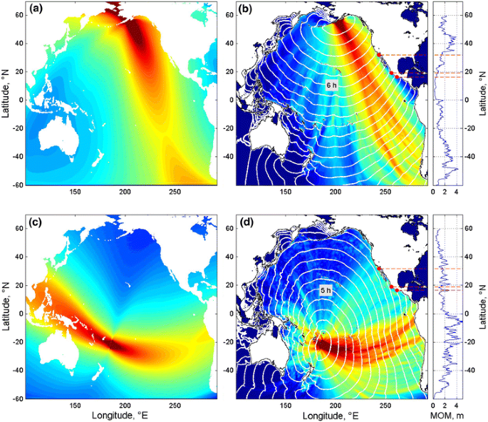
Tsunamis originated in the Aleutian and Tonga Trenches propagated in a spherical ocean of uniform depth (a, c) and in a spherical ocean with realistic bathymetry (b, d)
-
2.
A synthetic tsunami originated in the Tonga Trench (Fig. 15c, d) is also revealing hot spots along the coasts of Mexico and Chile, despite being mainly focused towards the coast of Peru.

Rights and permissions
About this article

Cite this article
Ortiz-Huerta, L.G., Ortiz, M. & García-Gastélum, A. Far-Field Tsunami Hazard Assessment Along the Pacific Coast of Mexico by Historical Records and Numerical Simulation. Pure Appl. Geophys. 175, 1305–1323 (2018). https://doi.org/10.1007/s00024-018-1816-y
Received:
Revised:
Accepted:
Published:
Issue Date:
DOI: https://doi.org/10.1007/s00024-018-1816-y