
Abstract
As a specific assemblage of rocks and minerals, ore deposit is the product under the joint action of structure, magma, fluid and mineralizing activities in a long geological time, which is in a limited distribution range and fixed in spatial output position, shape and occurrence. The material composition of ore bodies (ores) is different from that of surrounding rocks (nonore), and some are even diametrically opposite.
You have full access to this open access chapter, Download chapter PDF
As a specific assemblage of rocks and minerals, ore deposit is the product under the joint action of structure, magma, fluid and mineralizing activities in a long geological time, which is in a limited distribution range and fixed in spatial output position, shape and occurrence. The material composition of ore bodies (ores) is different from that of surrounding rocks (nonore), and some are even diametrically opposite. Thus, the ore deposits (types) formed under different geological backgrounds and along with different geologic and tectonic evolutions take on different performance characteristics, hence different prospecting methods as well as technical integration of effective prospecting methods. As one of the most complex orogenic belts in the world, the Sanjiang area has gone through not only the tectonic evolution of Tethys, but the fierce transformation of India-Eurasian Plate collision and plateau uplift. Therefore, the Sanjiang area is characterized by the most complicated structure, the strongest magmatic activities, the most active mineralizing fluid and complicated and diverse mineralization, thereby becoming a world-known metallogenic belt of nonferrous and precious metals. But simultaneously, the Sanjiang area is also the most complicated area in topography and geomorphology. Given the complex geomorphological landscape in the deep cut mountains and canyons in the Sanjiang area as well as the coverage of vegetation and ice deposits, conventional prospecting methods are no longer useful, particularly the geophysical prospecting technologies. The vast number of geological workers in the Sanjiang area have been pursuing how to make use of mature methods of geophysical prospecting, geochemical prospecting and remote sensing, while actively introducing and innovating new methods and technologies. Many methods have been successfully applied in the Sanjiang area and played a crucial part in guiding the discovery and evaluation of some ore deposits. However, with the increasing difficulty of ore prospecting, conventional and single methods may fail to help ore prospecting and exploration. Therefore, while introducing new methods and technologies, consistent efforts shall be made to explore the adaptability of various methods to topography and geomorphology and the effectiveness of different types of ore deposits in use and innovate the integration of methods and technologies. Yunnan's basic geological work has been done well. All types of geological techniques and methods have been widely applied, new technologies and methods have been used early, and exploration has gone deep. Apart from the area-based basic survey work, different prospecting methods and exploration techniques have been applied to the metallogenic provinces and belts with different metallogenic backgrounds. In the gold mineralization belt (such as Ailaoshan Gold Deposit Belt), relevant surveys have been conducted, including a geochemical survey of 1:10,000—1:25,000 soil in 1: 200,000 stream sediment anomaly areas (belts) and a geochemical survey of 1:50,000 stream sediment or 1:50,000 soil in many polymetallic metallogenic zones of gold, copper, lead, zinc and silver; geochemical survey of 1:50,000 stream sediment and 1: 50,000 soil in some areas simultaneously for comparison; 1:100,000 aeromagnetic survey and 1:100,000 ground gravity survey in the prospecting target area where concealed deposits are predicted (for example, the gravity survey of potassium salt in Pu'er Basin exceeds 10,000 km2, and the evaluation of Hetaoping copper-iron mine is 400 km2); and 1:10,000: 50,000 high-precision magnetic survey in ore-concentrated areas of iron, nonferrous metals and precious metals with magnetic conditions. Besides, we have conducted remote sensing interpretation of different data sources, applied hyperspectral and PIMA methods and used the Transient Electromagnetics (TEM), EH-4 electrical conductivity imaging system and controlled source audio magnetotelluric sounding earlier. Thanks to decades of practice and application, we have probed into five sets of effective integrated technologies for ore prospecting (exploration) in the prospecting practice in the Sanjiang area and achieved fast and efficient prospecting and exploration evaluation.
The following integrated technologies have been brought forward in a targeted manner, respectively, the integrated technology of “porphyry ore deposit model + hyperspectral + PIMA + high-precision magnetic survey + IP” for porphyry copper deposits, the “metallogenic model + horizon + Transient Electromagnetics + Induced Polarization” for VMS ore deposits, the integrated technology of “shear zone + geochemical exploration” for structurally altered rock type (orogenic belt) gold deposits, the integrated technology of “structural trap + hydrothermal circulation center + multiple electrical methods” for hydrothermal vein type Pb–Zn-Ag polymetallic deposits, and the integrated technology of “metallogenic system + gravity + magnetism + multiple electrical methods” for prospecting skarn/porphyry concealed deposits. These integrated technologies of ore prospecting have been extensively used.
6.1 Integrated Technologies for Exploration of Porphyry Copper (Gold, Molybdenum) Ore Deposits
In terms of porphyry copper (gold, molybdenum) ore deposits, we have achieved a breakthrough in prospecting Pulang porphyry copper deposits through the integration of “porphyry ore deposit model + hyperspectral + PIMA + high-precision magnetic survey + IP”.
6.1.1 Background of Ore Deposit Prospecting
Pulang copper deposit is a significant enrichment area of porphyry copper polymetallic resources. In the early 1970s, two medium-sized copper mines, Hongshan (skarn) and Xuejiping (porphyry), were evaluated. The search for porphyry copper deposits in this area stopped since the exposed rock bodies are mostly intermediate-basic porphyry and the old belief that porphyry is beneficial to iron formation rather than copper formation. Given the discovery of porphyry copper–gold deposits and gold ore deposits associated with basic porphyry in some foreign regions, in 1999, Yunnan Provincial Bureau of Geology and Mineral Exploration and Development set up Gaoshan Company in collaboration with Britain's Billiton Corporation, which performed geological exploration of risks mainly targeted at porphyry copper–gold deposits, conducted 1:100,000 aeromagnetic survey in Gezhongza area, Shangri-La, and delineated several copper mineralization bodies in Pulang copper–gold prospecting area. Therein, drilling verification has been performed on the Qiansui magnetic anomaly of Pulang porphyrite (porphyry) rock mass. Three boreholes have been drilled on Pulang porphyrite (porphyry). The ore discovery of the first hole is good, while that of the second and third holes are of poor. In the Qiansui borehole, there are chiefly thicker magnetic bodies composed of pyrite, pyrrhotite and magnetite. In 2001, the BHP Billiton Group decided to withdraw from the venture exploration in this area.
The Ganzi-Litang oceanic crust subducted westward to shape Yidun Island Arc. The difference of plate structure and the nonuniformity of subduction speed may have resulted in the different subduction angles caused by the tearing of plate during the westward subduction. The plate in the northern section of the ocean crust is at a steep subduction angle and a fast speed, and an extensional arc characterized by inter-arc rift and back-arc-basin, namely Changtai arc, takes shape, which results in the formation of VMS Pb–Zn-Cu deposit (Xiacun) and epithermal Au–Ag-Hg ore deposit. The plate in the southern section of the ocean crust is at a gentle subduction angle and a fast speed, and a compressive arc characterized by andesite volcanic rocks and intermediate-acid porphyry, namely Shangri-La Arc, takes shape (Fig. 6.1). Therefore, on the basis of the key scientific and technological projects of the Ministry of Land and Resources, the research project entitled “Comprehensive Research on Mineralization Law and Prospecting Direction of “Three Rivers” in Southwest China” arranged by China Geological Survey has always insisted that conditions are available for looking for porphyry and skarn copper (molybdenum and gold) in Pulang area.

Background for formation of Shangri-La Porphyry copper zone in Yidun Island arc zone
The members of the project team conducted a great deal of research and learned that this area is not only covered with both the intermediate-basic porphyry as known before and the widely distributed and large-scale intermediate-basic porphyry. From their perspective, magma in this area is in a complete evolution sequence, and all sorts of magmatic rocks range from basic to neutral to acidic. They state that favorable conditions are available in this area for looking for large porphyry copper deposits: ① fierce magma differentiation has occurred to the large-scale mother magma of porphyry in this area, producing copper-containing acidic porphyry magma, which can be described as “fat mother and strong baby”; ② a large area of propylitization and potassium silication has developed from the porphyrite/porphyry complex rock mass with lithofacies differentiation, confirming that a magma-fluid system associated with porphyry copper deposits has developed in the late phase of porphyry evolution; ③ Among the three verification holes, good porphyry copper mineralization is discovered in one borehole, which demonstrates an enormous potential of copper resources. Therefore, despite the “two ups and two downs” of this area, the project team members still believe in the prospects of prospecting. In 2002, the members of the project team made a special report to China Geological Survey with new research knowledge and new progress made in field investigation, which was highly valued by the China Geological Survey, allocating one million (RMB) to continue exploration and outcrop exposure. Expected results were achieved through surface exposure and further research. In 2003, the China Geological Survey included the prospecting of this area into a new round of major land and resources survey project and carried out large-scale explorations, launching the copper mine evaluation in Shangri-La area again.
6.1.2 Integrated Technologies for Exploration
The breakthrough of prospecting ideas has laid the foundation for making the breakthrough of prospecting, and the selection of prospecting methods (integration) is a key link to achieve the effectiveness and fast evaluation of prospecting. In Pulang area, we made the breakthrough of prospecting through the integrated technologies of “porphyry ore deposit model + hyperspectral + PIMA + high-precision magnetic survey + IP”.
6.1.2.1 Porphyry Ore Deposit Model
The ore deposit model of porphyry copper deposit has become relatively mature. The wall rock alteration in the porphyry body i inside out, generally silicification (core)—potassium silicified zone (biotite-potash feldspathization zone)—phyllic zone (quartz-sericitization zone)—(argillization zone)—propylitization zone- (skarn) hornfelsization zone and the mineralization types also correspondingly vary from being free from ore core—sparse (dotted) disseminated—dense (veinlet) disseminated—contact metasomatism (skarn-type)—filling metasomatic (big vein type) in wall rocks, in line with a clear distribution law. Therefore, the prospecting of porphyry copper (molybdenum and gold) deposits must be conducted under the guidance of the metallogenic model of porphyry copper (molybdenum and gold) mines. The mineralization of Pulang copper deposit can be summarized as below.
-
(1)
Ganzi-Litang Ocean Basin began to subduct westward in the Early Triassic, leaving the Shudu ophiolite melange only and foming the southwest porphyry belt (242.92–237.5 Ma), in which the Xuejiping porphyry copper mine (the isochron age of whole ore rock + biotite Rb–Sr is 224.6 Ma, Tan Xuechun 1985) was produced; large-scale subduction occurred in the Late Triassic. After a large number of dacitic volcanic eruptions broke out, large-scale subvolcanic rocks (e.g., quartz diorite porphyry) and intrusive rocks (e.g., quartz monzonite porphyry) (218–203 Ma) developed in succession, forming complex rock masses. The mineralizing 40Ar/39Ar age of Pulang porphyry copper deposit is 213–216 Ma; the Re-Os isochron age of molybdenite is 213 Ma ± 3.8 Ma, which is a typical ore deposit shaped in the Indosinian period.
-
(2)
Quartz dioritic porphyrite is distributed in a large area, generally the mineralization of pyrite, chalcopyrite, etc. Industrial ore bodies are chiefly produced in quartz monzonite porphyry, and some vein ore bodies are produced in granodiorite-porphyry and other wall rocks.
-
(3)
Copper, the main ore-forming metal, chiefly occurs in chalcopyrite, and a minute quantity occurs in bornite and covellite, distributed in porphyry (porphyrite) in the fine-vein disseminated and fine-grained—fine-grained sparse and dense disseminated form together with pyrite. A large vein-shaped ore body is shaped in the outer zone, which takes a “three-story” mode of porphyry copper granular disseminated, fine-meshed vein disseminated and large vein-shaped ore body.
-
(4)
The alteration zoning of ore-bearing rock body in Pulang copper deposit is obvious, with strong silicification zone (local), potash feldspar biotitization zone, quartz-sericitization zone, propylitization zone (local illite-carbonatization zone) and skarn hornelialization zone developed from the center. Among them, propylitization zone and hornelialization zone are developed, with large earth surface distribution area. Compared with the complete alteration zone of porphyry copper deposit, the argillic zone of this copper deposit is not developed, with the wide range of propylitization zone. The ideal model is shown as Fig. 6.2. The distribution of the main trace elements, like Cu, Mo, Au, Ag, Pb, Zn, W and Bi, in the rock have the characteristics of annular zoning with the rock mass as the center. While Cu and Mo (W, Bi) are in the inner zone, Cu and Au are distributed across the rock mass and surrounding rock, and Ag, Pb and Zn are in the outer contact zone.
Fig. 6.2 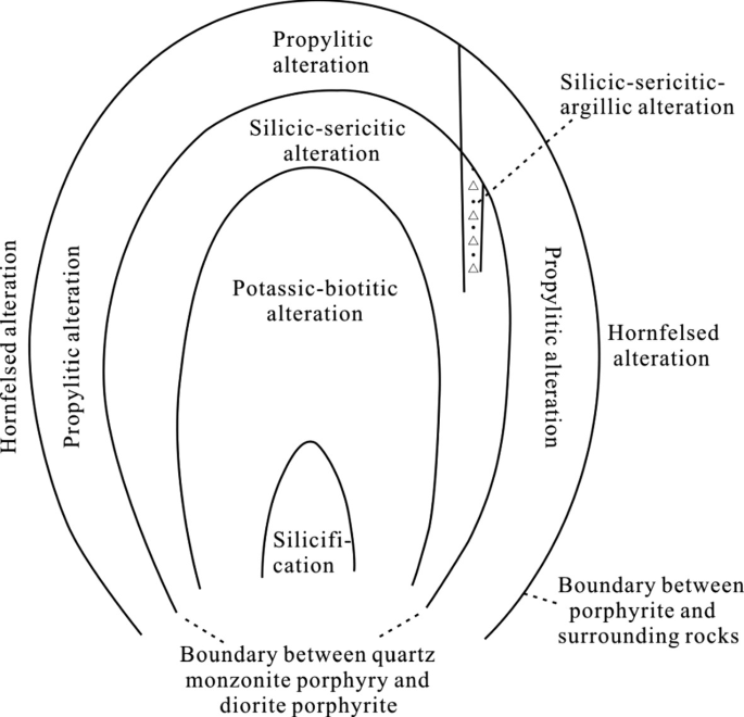
Alteration zoning pattern of Pulang copper deposit in Shangri-La
-
(5)
Ore body shape. In the plane, the ore body is in the shape of a “gourd”, and it is wide in the south and narrow in the north and lies to the north. In the section, the ore body inclines eastward, and it is speculated that there is uplift on the east. Industrial ore bodies mainly occur in quartz monzonite porphyry. The middle and upper part of quartz monzonite porphyry show veinlet disseminated state, while the lower part of it present dense and sparse disseminated state, and the upper porphyrite has a vein ore body, forming a “three-story” mineralization style (Fig. 6.3).
Fig. 6.3 
Schematic diagram of output forms of different types of ores (bodies)
-
(6)
Metallogenic Temperature. The homogenization temperature of copper ore mostly concentrates in four ranges (160–180 ℃, 180–210 ℃, 280–320 ℃, 300–430 ℃) (multi-phase inclusions), and the average Th values are roughly 170 ℃, 230 ℃, 305 ℃ and 360 ℃.
-
(7)
Metallogenic Epoch. According to the Re-Os date of molybdenite and K–Ar date of mineralized porphyry, the activity time of potash selection (biotitization and potash feldspathization) biotite quartz monzonite porphyry mineralization in Pulang porphyry copper mine is roughly 235.4 Ma ± 2.4 Ma to 221.5 Ma ± 2.0 Ma, and the Re-Os age of molybdenite in quartz-molybdenite stage is roughly 213 Ma ± 3.8 Ma, both ages of which are very similar. The mineralization of Pulang porphyry copper deposit was completed in the Indosinian period.


-
(8)
Mineralization Stage. According to the mineral assemblage and production characteristics of the ore deposits in the mining area, the metallogenic period of mineralization can be divided into ① Late magmatic mineralization. It refers to the mineralization of potassium-rich magmatic gas and liquid, which is carried out upward and outward from the rock mass without Tianshui, and forms biotite-potash feldspar-metal mineralization association with potassium. ② The post-magmatic hydrothermal metallogenic period: It is the most important metallogenic epoch, and all types of major mineralization are formed by this mineralization. From early to late, from inside to outside, from high temperature to low temperature, the mineralization can be divided into three stages. In the high temperature stage, quartz-biotite-potassium feldspar-metal sulfide association is formed in porphyry; in the medium temperature stage, quartz-sericite-metal sulfide association was formed in porphyry; in the low-temperature stage, with weak mineralization, only a few veinlets of propylite -chalcopyrite-pyrite assemblage are produced, and no ore body is formed. ③ The super-gene period: The super-genesis in the shallow part near the west and southeast of KT1 ore body is strong, which causes the metal minerals chalcopyrite, pyrite and pyrrhotite to oxidize into limonite and malachite. The oxidation zone is 10–40 m in depth. The copper in the oxidation zone is partially leached, so the copper grade of ore body decreases, and the copper sulfate solution formed in the oxidation process forms carbonate copper mineral.
The model of Pulang copper deposit is shown as Fig. 6.4.

Metallogenic model of copper deposits related to porphyrite in Shangri-La area. 1-Tumugou formation; 2-Qugasi formation; 3-quartz monzonite porphyry; 4-quartz dioritic porphyrite; 5-propylitization zone; 6-argillic zone; 7-Sericitization zone; 8-potassium silicification zone; 9-silicified nucleus; 10. hornstone skarnization zone; 11-sandstone slate; 12-limestone; 13-intermediate volcanic rocks; 14-basic volcanic rocks; 15-porphyrite; 16-quartz monzonite porphyry; 17-argillization; 18-skarn ore body; 19-vein ore body; 20-porphyry reticulated ore body; 21-disseminated ore body; 22-lithologic and lithofacies erathem of intrusive rocks; 23-alteration zoning erathem; 24-mineralization type erathem and serial number; 25-magmatic intrusions and rising direction of gas and liquid in the late period; 26-migration direction of mixed hydrothermal liquid
6.1.2.2 Extraction of Hyperspectral Data (Hyperspectral Images) and Alteration Information
Remote sensing hyperspectra are used to identify magmatic rock belts and main alteration types, infer concealed rock masses and delineate exposed rock masses.
In November 2003, Yunnan Geological Survey purchased hyperspectral data (hyperspectral images) of 4 scenes in Pulang area of Shangri-La County. Yunnan Geological Survey has successively cooperated with Professor Wang Runsheng from China Aero Geophysical Survey and Remote Sensing Center for Land and Resources (AGRS) and Professor Hu Guangdao from China University of Geosciences (Wuhan) to interpret and analyze, which provide a basis for delineating and tracing the distribution of magmatic rock belts, the spreading characteristics and main alteration types of alteration belts in this area. The following is an introduction to the interpretation of Professor Hu Guangdao and other research groups. In the extraction of altered mineral information, the spectral angle mapping was adopted to identify altered minerals in “Gaochiping-Lannitang area” and “A’re-Pulang area”. The interpretation and analysis of A're-Pulang area are illustrated as follows: magmatic rocks in Pulang area are distributed in zone, three magmatic rocks zones can be delineated from north to south, including NW-trending Bidu-Zhuoma intermediate-acid magmatic rocks zone, NW-trending Disuga-Songnuo-Pulang intermediate-acid magmatic rocks zone, and the close NS-trending Chundu-A're intermediate-acid magmatic rocks zone (Fig. 6.5). By processing the hyperspectral data and extracting the alteration information of A’re-Pulang-Langdujing, most altered areas are consistent with the known porphyry bodies (Figs. 6.6, 6.7 and 6.8).

Geological Diagram of A’re-Pulang-Langdu area

Hyperspectral image map of A’re-Pulang-Langdu area

Extraction of Altered Minerals from A’re-Pulang-Langdu (SAM, Threshold = 0.2)

Distribution characteristics of alteration zone in Pulang copper deposit and its vicinity
6.1.2.3 PIMA Application
The ore-bearing porphyry bodies and alteration zoning can be rapidly delineated within complex rock bodies by using PIMA technology.
Mineral mapping is a spectral mapping technology developed on the basis of hyperspectral remote sensing. The spectral interval used for mineral mapping is in the infrared region. At present, short wavelength infrared has been applied to observe minerals containing water or OH and some sulfate minerals and carbonate minerals.
As a new concept, the purpose of mineral mapping is to determine the distribution and relative content changes of one mineral or some minerals on earth surface, and it can also be used to determine rock and mineral samples from deep. Given the high resolution of hyperspectral remote sensor, it is feasible to map out the distribution of target minerals from spectral images and determine their relative abundance at the same time. Here, the concepts of stratum, rock stratum or rock mass in the traditional geological significance are not taken into consideration, and the basic unit of mapping has been as small as a single mineral. The distribution of individual mineral may be controlled by primitive lithology and may also be caused by late geological processes (hydrothermal alteration, tectonic deformation, weathering and denudation, etc.) or modern human activities. As the mineral map can provide information related to various geological processes in the late period and even human activities after the formation of stratum and rock stratum, the mineral map can be used in the fields of prospecting, engineering geology, natural disaster monitoring and environmental pollution investigation. In terms of mineral prospecting and exploration, the mineral map directly provides information on mineral distribution and abundance related to mineralization. With mineral information and the genetic model of ore deposits, the detailed investigation and exploration targets can be effectively determined. In addition, the rock mass erathem and mineralization range can be roughly delineated through a combination of high-precision magnetic survey and induced polarization (IP) method, realizing a breakthrough in rapid prospecting.
PIMA portable near-infrared spectrometer produced by Integrated Spectronics Pty Ltd (Australia) was used in rock (ore) samples test in Pulang copper deposit. The PIMA was applied by Lian Changyun and other researchers from the Development Research Center of China Geological Survey and Yunnan Geological Survey.
A total of 18 altered minerals were identified by PIMA, which are listed as follows in order of quantity: anhydrite, illite, magnesium-chlorite, hydrated kaolinite (halloysite), ferromagnesian-chlorite, hornblende, ferrochlorite, muscovite, biotite, montmorillonite, phengite, actinolite, tremolite, calcite, phlogopite, dolomite, tourmaline and kaolinite.
One principle for sampling is that the sampling is carried out at a certain dot spacing (generally 5 m dot spacing, which can be made denser to 1–2 m in areas with strong alteration) along the existing exploration line profile. The earth surface and profile measurement are based on exploratory trench and borehole core, respectively. Another sampling principle is to make the samples representative.
Core samples from 9 boreholes and rock samples from 2 earth surface long profiles were collected in Pulang porphyry copper deposit area. A total of 927 core samples were collected from these 9 boreholes. The collection of earth surface samples is mainly concentrated on the 0 exploration line and 0’ exploration line. Part of two profiles were exposed, with samples taken from the exploratory trench; where the engineering disclosure was not carried out, sampling was conducted on the surface outcrop. The actual control length was 2249 m, and 356 samples were collected. In order to test the effectiveness of PIMA instrument in mineral identification and delineate alteration zoning, representative samples were selected from the samples tested by PIMA instrument for optical thin slice identification at the same time. Some projects were added according to the “cross” profile. A total of 460 optical thin slice samples of rock-mineral were collected for comparison and comprehensive identification.
According to the spectral measurement results, at least, the following three main alteration zones can be identified in Pulang porphyry copper deposit area:
-
(1)
Potassic alteration zone: It is mainly characterized by abundantly developing biotite (sometimes phlogopite) and actinolite, and it is super-imposed with chlorite, illite, anhydrite and other minerals (Fig. 6.9). There are a lot of actinolite in this zone. This indicates that the denudation of porphyry metallogenic system is relatively light, for actinolite is formed by oxidation due to acid alteration near the earth surface. Generally speaking, there are many biotites in the Pulang porphyry copper deposit area, which indicates that potassium alteration is an important thermal event in this area. According to the law of porphyry metallogenic system, the dispersed biotite alteration often occurs in the early stage of mineralization, with a relatively large range. After that, the potassic alteration zone was super-imposed and transformed by sericitization in the late period, so more chlorite and illite can be seen in ZK0608 borehole.
Fig. 6.9 
Biotite distribution identified in profile of 0 exploration line of Pulang porphyry copper deposit area
-
(2)
Sericitization zone: It is characterized by developed sericite (mainly illite here), chlorite and anhydrite, which formed a halo around the potassic alteration zone. Illite is the main altered mineral in this zone, and some places are distributed with muscovite and polysilicate muscovite. This zone tends to, but not always strictly controlled by porphyry bodies. The main ore body in Pulang copper deposit is located in this zone.

-
(3)
Argillic zone: This zone is mainly composed of montmorillonite, illite and chlorite are also distributed. This zone is mainly located outside the sericitization zone. The appearance of large amount of montmorillonite in the periphery means that montmorillonite was formed in the late stage of mineralization due to faults or the infiltration of cold groundwater of breccia zone. Montmorillonite represents the last stage of mineralization of Pulang porphyry copper deposit.
Figure 6.10 shows the spatial variation characteristics of altered minerals depicted by spectral measurement results in Pulang porphyry copper deposit area. Figure 6.11 demonstrates the zoning of altered minerals inferred according to the spatial distribution and variation characteristics of altered minerals. From Fig. 6.11, the altered mineral zoning obtained by PIMA has obvious asymmetric characteristics. The potassic zone of altered center is located in the eastern part of the mining area, in which low-grade copper ore bodies are produced. Sericitization zone is located above and on the east side of the main ore body, and it is the main output part of the copper ore body. The narrow argillic zone, which is located in the west of the mining area, is marked by the increase of altered minerals, including montmorillonite.

Spatial distribution characteristics of altered minerals measured by PIMA instrument in Pulang porphyry copper deposit area

Altered minerals zoning measured by PIMA in Pulang porphyry copper deposit area
Application of PIMA in ore prospecting. Based on the model of altered mineral zoning and the mineralization law of porphyry copper deposit, the prospecting prediction area of Pulang porphyry copper deposit area was delineated (Fig. 6.12), which provides guidance for the exploration of similar deposits in unknown areas.

Schematic diagram of prospecting deployment area in Pulang porphyry copper deposit area. Interpretation and inference map of comprehensive profile of 26 exploration line in Pulang mining area
According to the altered mineral zoning model established by us, further prospecting in Pulang porphyry copper deposit area should be confined to the annular range centered on ZK0608 borehole, that is, to increase exploration efforts in the periphery of potassic alteration zone and sericitization zone. Given characteristics of ore body formation, results of geological, geophysical and geochemical exploration revealed, and the occurrence of rock mass and ore body, it is suggested that further exploration of porphyry copper deposits in Area A and northward of Area A in Fig. 6.12 should be conducted in the near future.
In terms of mining area evaluation, the prediction area map (Area A in Fig. 6.12) depicted by PIMA was drilled and verified without finding out the ore body shape and strike. The results show that the ore body extends to the northeast direction, and the lower part of the prediction area is the best ore-seeing position at present.
6.1.2.4 Magnetic and Electrical Measurement
On the basis of 1: 100,000 geochemical prospecting (water system) and 1: 50,000 geochemical prospecting (soil) survey, various geophysical and geochemical prospecting were carried out in the mining area, including 1: 10,000 IP intermediate gradient surface scanning, 1: 100,000 aeromagnetic survey, 1: 50,000 and 1: 10,000 high-precision magnetic survey, transient electromagnetic measurement (TEM), amplitude-frequency IP survey, etc. The results of high-precision magnetic survey and IP survey were better (Fig. 6.13).

Interpretation and inference map of geophysical prospecting profile in Pulang deposit area
6.2 Integrated Technologies for Exploration of Volcanic-Associated Massive Sulfide Deposit (VMS) and Sedimentary Exhalative Deposit (Sedex)
The massive sulfide deposit discussed in this section generally refers to volcanic-associated massive sulfide deposit (VMS) and sedimentary exhalative deposit (Sedex). Although these two types of ore deposits are different in terms of formation conditions and ore deposit characteristics, their common features are that there are ore-bearing beds and stratiform ore bodies, which generally contain high content of sulfides and magnetic minerals. The model of this kind of ore deposit has been studied deeply, so model prospecting is still an important prospecting method. During the prospecting, ore deposits with different occurrence types have different emphasis, but “metallogenic model + horizon + Induced Polarization” is an effective prospecting method. For exposed VMS deposit and Sedex deposit, in addition to “metallogenic model + horizon + Induced Polarization”, high-precision magnetic measurement of 1: 10,000 can be added to form an integrated technical method of “metallogenic model + horizon + Induced Polarization + magnetic method”. For deep buried deposits, the integrated technology of “metallogenic model + horizon + Transient Electromagnetics + Induced Polarization” was adopted, which delivered satisfactory results.
6.2.1 Integrated Technologies of “Metallogenic Model + Horizon + Transient Electromagnetics + Induced Polarization Method” Have Achieved a Breakthrough in Prospecting of Dapingzhang Copper Polymetallic Deposit
For rift metallogenic system in Yunxian-Jinghong rift zone (Wang Baolu et al. 2001), the initial time of its development has always been a hot issue. It is generally believed that the system originated from Carboniferous. Yang Yueqing (2000) determined that the diagenetic age of quartz porphyry in Dapingzhang mining area was 236 Ma (Rb–Sr isochronous age). However, the recent Re-Os isochronous ages (428.8 Ma ± 6.1 Ma to 432.4 Ma ± 5.6 Ma) obtained in Dapingzhang ore body indicate that the ore deposit was formed before Middle Silurian. This is of great significance for guiding further discussion of Tethys tectonic evolution and regional prospecting. Dapingzhang Cu-Pb–Zn polymetallic deposit is a submarine volcanic-sedimentary exhalative deposit (VMS deposit), which is distributed along volcanic apparatus and volcanic depressions in Jiufang fault zone. The metal elements of the ore deposit show vertical zoning, that is, the massive ore body of the upper basin facies is Cu-Pb–Zn-Au–Ag symbiotic assemblage; the metal element of lower pipeline facies veinlet disseminated ore body are dominated by Cu.
According to the composition, intensity of molten lava and types of volcanic eruptions from early to late, the primitive volcanic eruption process can be basically divided into one eruption cycle and three eruption sub-cycles.
The first eruption sub-cycle is dominated by a large amount of submarine sodium-rich molten lava. At first, quartz keratophyric molten lava spouted, then the composition of the molten lava turned into keratophyric material. At the same time, basic spilitic molten lava spouted in a short time and finally ended in submarine volcanic deposition. VMS deposits were formed during the intermittent eruption period. The second eruption sub-cycle not only has strong volcanic eruption activity but also has volcanic eruptions of a certain scale. At first, the eruption of rhyolitic molten lava and intermediate-basic molten lava dominated, but the eruption weakened in the medium term. In the intermittent period, volcanic breccia and tuff were produced by associated eruption. In the late period, eruption and outburst tended to weaken. Some tuff and sedimentary pyroclastic rocks far away from volcanic channels were formed. In the third eruption sub-cycle, volcanic activity is coming to an end. At the beginning of this eruption cycle, strong intermediate molten lava erupted, and then, it turned to the eruption of acid molten lava after a short break. Consequently, volcanic outburst dominated. Volcanic breccia was formed in this process. It finally ended with tuffaceous-siliceous rocks and normal sedimentary rocks formed by tuff.
Metallogenic mechanism: In the intermittent period of submarine volcanic eruption, Cu, Zn, Pb, Ag, and Au carried by volcanic jet-hydrothermal solution contain halogen and sulfur; driven by magmatic hydrothermal solution, groundwater derived from seawater produces convection, and leach minerals from rocks. When the ore-bearing hydrothermal solution rises to the vicinity of the submarine eruption outlet, the solution boils and gasifies due to pressure release. Then, the solution is injected into sedimentary depressions to form massive ore bodies. Volcanic depressions are the best exhalative metallogenic environment. There is disseminated (volcanic) hydrothermal Cu mineralization in the volcanic channel of volcanic rocks or the contact zone inside and outside the edge of the late volcanic dome. Then Dapingzhang disseminated copper ore bodies were formed.
The ore body occurs in the spilite keratophyre series, and the upper stratiform and stratiform-like massive ore body and the lower veinlet ore body are combined to form a “double-bed structure”. See Fig. 5.11 for the ore deposit model. The massive ore body mainly develops banded, striped and massive ore structures, and its ore metal minerals include sphalerite, chalcopyrite, pyrite, galena and silver tetrahedrite, with a total content of 83.83% (Yang Guilai). The massive ore body is characterized by rich sphalerite and chalcopyrite, and gangue minerals include quartz, calcite, sericite, chlorite and barite. The content of metal sulfide in disseminated ore is generally less than 35%, mainly including pyrite, chalcopyrite, trace sphalerite, galena, chalcocite, limonite, etc. The gangue minerals include quartz, calcite, sericite and chlorite. The alteration closely related to mineralization mainly develops silicification, chloritization and pyritization, etc. Three massive ore bodies are delineated. The average grade of ore bodies is Cu 2.14%-3.80%, Pb 0.52%-2.89%, Zn 2.60%-9.46%, Au 0.43 × 10⁻⁶−2.15 × 10⁻⁶, Ag 82.12 × 10⁻⁶−158.73 × 10⁻⁶. The average grade of disseminated ore body is Cu 0.92%, Pb 0.04%, Zn 0.21%, Au 0.52 × 10⁻⁶, Ag 10.91 × 10⁻⁶. Breccia ore is developed in the ore body, and the composition of breccia is basically the same as that of massive ore. It is inferred that after the formation of massive ore body, the ore body at the top of volcanic neck breaks and enters into volcanic neck to form breccia ore.
According to the characteristics of this type of deposit, in the prospecting of Dapingzhang copper polymetallic deposit, we have adopted various geophysical and geochemical prospecting methods to explore its integrated prospecting technology.
6.2.1.1 Comprehensive Geophysical Prospecting Experiment of Profile
The electrical and magnetic properties of rocks (ore) exposed in the area (mainly sandstone, mudstone, limestone, quartz keratophyre, rhyolite porphyry and sulfide ore, etc.) were measured. The results show that while the charge rate of ore is the highest (>30%), the apparent resistivity of ore is the lowest (<72.5 Ω · m). The ore has the characteristics of low resistivity and high polarization. The charging rate of tuff, dacite, mudstone and limestone containing little or no sulfide is extremely low, ranging from 3 to 4%. There are obvious differences in electrical properties between ore bodies and surrounding rocks, and there is a good geophysical premise for IP work in this area. The magnetic measurement of rock (ore) shows micro-magnetism or nonmagnetism, indicating extremely weak magnetism. There is not much difference between rock and ore in magnetic measurement, so it is obvious that magnetic measurement results show it does not have geophysical conditions.
We need to study the geophysical characteristics of ore deposits, understand the distribution range and burial depth of ore bodies as soon as possible, and guide the arrangement and construction of prospecting projects. So, firstly, we did comprehensive geophysical prospecting (IP sounding, spontaneous electric field, high-precision magnetic survey and charging survey) tests on geological exploration line 7 and exploration line 16. Then, Transient Electromagnetics tests were conducted on exploration line 1, 10, 16 and 57. Based on the tests, area IP intermediate gradient and self-electric measurement were carried out. It showed that the results of IP and Transient Electromagnetics were abnormal. IP intermediate gradient and self-electric measurement were in good agreement with ore bodies (Fig. 6.14).

Geological and geophysical prospecting model of exploration line 10 in Dapingzhang ore deposit
6.2.1.2 Area Comprehensive Geophysical Prospecting
Through the comprehensive test of five geophysical prospecting methods on the profile, the results of IP, self-electricity and Transient Electromagnetics are better, which affirms the effectiveness of these three geophysical prospecting methods. First, IP method is selected as the main method and technology to carry out surface scanning work.
The mining area was scanned for 9 km2 by 1: 10,000 IP middle gradient, and four IP intermediate gradient anomalies with M ≥ 10% were circled (Fig. 6.15). With engineering verification, industrial ore bodies and mineralized bodies are found in all projects constructed in anomalies. Physical property data and ore-seeing projects in the area show that the remaining abnormal values on ore bodies are all greater than 10%. Therefore, when there is a certain scale of anomaly, the residual value is generally greater than 10% and is ore-induced anomaly. This indicates that IP intermediate gradient has a certain effect on finding disseminated ore in Dapingzhang deposit, delineating the distribution range of mineralized body and guiding engineering layout.

IP intermediate gradient (Ms) anomaly diagram of Dapingzhang ore deposit
To sum up, the geophysical prospecting anomalies in this area are obvious. The ore-seeing rate of engineering verification is high, with remarkable prospecting effect.
Geophysical prospecting model: The plane distribution range and morphological characteristics of IP anomaly are in good agreement with copper polymetallic ore bodies exposed in outcrops or boreholes. The data of IP sounding and Transient Electromagnetics obtained from typical exploration profiles fully reflect the characteristics of low resistance and high polarization of copper polymetallic ore bodies. The geoelectric profiles of Ms, ρs and TEM are consistent with the exploration profiles, reflecting the spatial mode of occurrence of copper polymetallic ore bodies, as shown in Fig. 6.14. The geophysical prospecting model is characterized by the coincidence of IP intermediate gradient and TEM low resistivity anomaly. The residual abnormal value of IP intermediate gradient is greater than 10%. The Transient Electromagnetics has low resistivity, and the apparent resistivity is less than 200 Ω m. The combination of geophysical prospecting methods is effective under the specific metallogenic geological conditions and geophysical premise of Dapingzhang deposit area by measuring the area IP intermediate gradient and carrying out the area Transient Electromagnetics selectively.
After exploration, we put forward the integrated technology of “metallogenic model + horizon + Transient Electromagnetics + Induced Polarization” to find volcanic-associated massive sulfide deposit (VMS) similar to Dapingzhang copper polymetallic deposit. This is an effective integrated technology for prospecting.
6.2.2 Location Prediction of Ore Body in Luchun Zn-Cu-Pb (Ag) Polymetallic Ore Target Area
According to the geologic characteristics, ore deposit genesis, mineral symbiotic assemblage, mineral form of Zn-Cu-Pb component and physical properties of rocks and ores of Luchun Zn-Cu-Pb (Ag) polymetallic ore deposit, the geophysical prospecting methods such as high-precision magnetic method, Transient Electromagnetics and amplitude-frequency Induced Polarization are used to predict the location of ore body and the ore deposit, and good results have been achieved.
6.2.2.1 High-Precision Magnetic Method
6.2.2.1.1 Determination of Geological Physical Properties
60 specimens of rock magnetic were collected and measured for parameters determination in Luchun deposit (Table 6.1). With strong magnetism, the magnetic susceptibility of the massive ore is (36,520–239,270) 4 π × 10–6 SI, and the remanence is 1560 × 10–3–25,420 × 10–3 A/m. With weak magnetism, the magnetic susceptibility of the surrounding rock is (98–1627) 4 π × 10–6 SI in general, and its remanence is 50 × 10–3–1260 × 10–3 A/m. The statistical table of magnetic parameters shows that there are obvious magnetic differences between the mineralized body and surrounding rock. Therefore, it is considered that the anomaly is ore-induced anomaly, which has the physical property for implementing high-precision magnetic survey.
6.2.2.1.2 Characteristics of High-Precision Magnetic Anomalies
The high-precision magnetic method was arranged in the whole mining area, with a total of 15 exploration lines, showing good magnetic survey results for the known outcrop areas of ore bodies and the areas covered by plants, slope deposits and ice deposits (Figs. 6.16 and 6.17).

High-precision magnetic ∆T profile plan of Luchun deposit

High-precision magnetic Δ T plane isoline map of Luchun deposit
The results of high-precision magnetic surface scanning in Luchun deposit showed that the intensity of magnetic anomaly in the north of exploration line P12 was large, with obvious magnetic gradient changes. The magnetic anomaly was consistent with the horizon and strike of mineralized body in the mining area. The middle ore section was basically connected with the mineralized bodies in the north ore section and the south ore section in the strike. The ore sections were not staggered or discontinued by the large displacement of the close east–west fault. The outcrop of the shallow mineralized bodies had a certain downward displacement due to the landslide. The south area of exploration line P12 is the extension section of this work, without any outcrop. Covering by vegetation and slope deposits, the extension section showed a low and slow magnetic anomaly. Magnetic survey anomaly showed that there were mineralized bodies beneath the overburden, which were connected with mineralized bodies in the south ore section in strike. The magnetic anomaly (mineralized) body in the upper ore-bearing bed extends steadily from north to south, with a length of 3600 m from north to south and a width of 60–200 m from east to west. Moreover, in the range of 2000 m between exploration line P11-P10, not only high positive magnetic anomalous zone appears on the mineralized bodies, but also obvious negative magnetic anomalous zone appear on the west side of the positive magnetic anomalous zone. The spatial “pairing” arrangement of positive and negative magnetic anomalous zones indicates that the mineralized bodies (stratiform ore bodies) tend to the east with good continuity in strike. In addition to the obvious magnetic anomaly characteristics in the upper ore-bearing beds, there were also magnetic anomalies in the lower ore-bearing beds on the west side of exploration line P10 and P8.
6.2.2.1.3 Analytical Continuation of Magnetic Anomaly
Through analytic continuation of anomalies, which is produced by magnets at a certain spatial position below the earth’s surface, the anomalies are highlighted. When using the existing analytical continuation method of potential field to extend downward to the region near the top surface depth of the field source body, the potential field will have strong oscillation, and the vertical super-position body cannot be clearly distinguished. By introducing the relevant correction functions such as potential field frequency and buried depth with regularization factor, the field value is not singular when downward continuation passes field source body by computer processing. In this condition, it can reach any required depth below the field source body by downward continuation.
6.2.2.1.3.1 Upward Continuation of Magnetic Anomaly
Upward continuation is to calculate the abnormal value of a certain height above the ground according to the measured abnormal value on the ground. The purpose is to suppress the interference of shallow magnets and highlight the meaningful anomalies produced by deep-seated magnets. In fact, upward continuation is equivalent to improving the observation plane, and the anomaly curve obtained after continuation mainly reflects the anomaly characteristics of deep-seated magnets. By using upward continuation, deep-seated magnets can be found, and local anomalies and regional anomalies can be divided.
The upward continuation of magnetic anomaly in Luchun deposit has been carried out in several heights (0 m → 25 m → 50 m → 100 m → 200 m → 300 m → 500 m) (Figs. 6.17, 6.18 and 6.19). According to the results, at the height from 0 to 50 m, there are many magnetic anomaly centers between exploration line P7 and P5, exploration line P1 and P0, exploration line P4 and P6, exploration line P6 and P8, exploration line P8 and P12 respectively in the north of exploration line P12. There are still low and slow anomalies in the south of exploration line P12. When upward continuation is carried out at the height from 100 to 300 m, the magnetic anomaly center in the north of exploration line P12 only appears between exploration line P7 and P5, exploration line P8 and P12. The magnetic anomaly in the south of exploration line P12 still shows a low and gentle anomaly. When upward continuation is carried out at the height of 500 m, the magnetic anomaly center between exploration line P7 and P5 moved southward to exploration line P5 and P3, and the magnetic anomaly center between exploration line P8 and P12 moved northward to exploration line P8 and P10. The low and slow anomaly south of exploration line P12 was not obvious.

Plane isoline map of high-precision magnetic survey in Luchun deposit (100 m upward continuation)

Plane isoline map of high-precision magnetic survey in Luchun deposit (500 m upward continuation)
The upward continuation results of magnetic anomaly in Luchun deposit show that magnetic anomalies and anomalous bodies are stable and continuous in a certain depth range along dip and strike. The maximum extension depth of magnetic anomalous bodies along dip direction lies between exploration line P5 and P3 in the north ore section and between exploration line P8 and P10 in the south ore section. This is also the center of deep magnetic anomalous bodies. The characteristics of dense isoline in the west and sparse isoline in the east show that the magnetic anomalous body inclines eastward. This is also consistent with the actual observation of geological profile of the ore deposit.
6.2.2.1.3.2 Downward Continuation of Magnetic Anomalies
Downward continuation is to calculate the anomaly value of a certain depth below the ground according to the measured anomaly on the ground. Downward continuation is equivalent to reducing the height of the observation plane, aiming at distinguishing super-imposed anomalies and highlighting anomalies caused by deep-seated magnets. By using downward continuation, we can explore the spatial occurrence and depth of deep magnets extending downward, thus realizing two-dimensional spatial recourse of anomalous bodies.
The magnetic anomalies of 15 magnetic side profiles in Luchun deposit are extended 250 m below the earth surface, and the magnetic anomalies of seven exploration line P9, P7, P1, P0, P2, P6 and P10 are fitted by computer in shape spatial occurrence (Figs. 6.1, 6.2, 6.20 and 6.21). It can be seen from the figure that the magnetic anomaly characteristics in the upper ore-bearing bed are obvious and tend to become larger when downward continuation is conducted to the depth range of 250 m in the north of exploration line P12. The anomalous bodies fitted by computer all show stable extension, and it is a plate-like body and tends to the east. The ore body exposed between exploration line P0 and P2 has a certain downward displacement due to landslide. There are also anomalous bodies in the lower ore-bearing beds on the west side of exploration line P10. The low and gentle anomalies in the south of exploration line P12 extend downward to the depth range of 250 m, and the characteristics of magnetic anomalies are obvious in-depth ranges of 100–250 m below the overburden. The maximum downward continuation of magnetic anomalies and anomalous bodies in Luchun deposit is located in the area of exploration line P7, P5 and P3 in the north ore section and area of exploration line P6 and P8 in the south ore section. The downward continuation depth of plate-like magnetic bodies can be 300–400 m.

Comprehensive map of geological profile and downward continuation profile of magnetic anomaly of exploration line P0 of Luchun deposit

Comprehensive map of geological profile and computer fitting profile of anomalous bodies of P0 exploration line of Luchun deposit
The downward continuation results of magnetic anomaly in Luchun deposit show that the magnetic anomaly in north of exploration line P12 and the anomalous body extending along the dip range of 250 m below the earth’s surface are relatively stable and continuous. The anomalous body is a plate-like body with dip to the east. In Quaternary overburden area in the south of exploration line P12, there are magnetic anomalies in depths from 100 to 250 m below the overburden. The maximum downward continuation of magnetic anomalies and anomalous bodies in Luchun deposit is located in the area of exploration line P7, P5 and P3 in the north ore section and in the area of exploration line P6 and P8 in the south ore section. The downward continuation depth of plate-like magnetic bodies can be 300–400 m, which is consistent with the location of magnetic anomaly center displayed by upward continuation. The spatial distribution of magnetic anomalies and anomalous bodies in Luchun deposit is consistent with the configuration of the measured geological profile of the ore deposit. It also corresponds to the spatial position of mineralized bed (bodies) in the profile one by one. In addition to the obvious magnetic anomalies and anomalous bodies in the upper ore-bearing beds, there are also magnetic anomalies and anomalous bodies in the lower ore-bearing beds on the west side of exploration line P10 and P8.
6.2.2.2 Transient Electromagnetics (TEM)
6.2.2.2.1 Arrangement of Transient Electromagnetics (TEM) Exploration Line
The ore body of Luchun deposit is rich in magnetite and Zn-Cu-Pb sulfide minerals, so it has the physical properties for Transient Electromagnetics (TEM) detection. Through TEM, the deep-seated spatial occurrence of Luchun mineralized body can be detected. Nine east–west direction exploration line profiles were arranged in Luchun deposit, which are exploration line P9, P5, P3, P0, P6, P8, P10, P12 and F from north to south. Among them, overlapping loops were arranged in exploration line P9, P0, P6, P10, and F with a dot spacing of 50 m. Large fixed-loop sources were arranged on exploration line P5, P3, P8 and P12 with a dot spacing of 25 m and the control depth of 350–500 m.
6.2.2.2.2 Results of Transient Electromagnetics
The detection of nine geophysical prospecting profiles in Luchun deposit was conducted by overlapping loops method and large fixed-loop source method, with the controlled depth of 350–500 m. Effective results are shown in the known outcrop areas of ore bodies and the areas covered by plants and slope deposits (Figs. 6.16, 6.17, 6.22 and 6.23).

Comprehensive map of geological profile and TEM apparent resistivity section of exploration line P9 of Luchun deposit

Comprehensive map of geological profile and TEM apparent resistivity section of P10 exploration line of Luchun deposit
The TEM results for deep exploration of Luchun deposit show that the mineralized body in the north of exploration line P12 extends steadily and continuously to the deep, with obvious low resistance body and low apparent resistivity (ρs value: 0–25 Ω m). The stratiform mineralized bodies tend to extend up to 200–250 m along the dip. In Luchun deposit, the spatial distribution of low resistance body is consistent with that of magnetic anomalies and anomalous bodies and also roughly corresponds to the configuration of the measured geological profile of the ore deposit. There are two large-scale tubular low resistance bodies beneath the stratiform mineralized bodies in exploration line P9 in the north ore section and exploration line P10 in the south ore section in Luchun deposit, respectively, with apparent resistivity value of 0–25 Ω·m. These two tubular low resistance bodies are presumed to be tubular mineralized bodies beneath the stratiform ore bodies. There are low resistance bodies beneath the vegetation and slope deposit overburden in the south of exploration line P12. The location of the low resistance bodies is basically consistent with the range of high-precision magnetic survey anomalies, and it is presumed that the low resistance bodies are mineralized bodies. The depth of the overburden varies from 50 m (east) to 120 m (west), and the low resistance bodies can connect with the mineralized bodies (beds) of exploration line P10 in space to the north.
6.2.2.3 Amplitude-Frequency Induced Polarization
Amplitude-frequency Induced Polarization is a technique used to detect the difference of electric field by taking advantage of the slowness of polarization process and adopting different frequency currents to excite polarized bodies to different degrees. As amplitude-frequency induced polarization can detect IP effect and measure apparent resistivity and amplitude-frequency effect simultaneously, it can be used to detect various objects suitable for resistivity method. In addition, amplitude-frequency induced polarization has a strong ability to find sulfides. Generally, sulfides can be found effectively only if their content is only 1% or even lower. Most nonferrous and precious metal deposits are closely related to sulfides, and they can be detected effectively by IP method.
There are a large number of strongly polarized sulfide minerals such as magnetite, pyrite, chalcopyrite, galena, sphalerite, chalcocite and hematite in Luchun zinc-copper-lead (silver) polymetallic ore deposit, which have the electrical conditions for carrying out Induced Polarization (dipole amplitude-frequency induced polarization detection). In 1998, the research group of Chengdu Institute of Geology and Mineral Resources conducted the “Research on Tectonic Evolution and Metallogenic Regularity of Copper and Gold Deposits in Jinsha River Junction Zone”. In the same year, the project group (a national key scientific and technological research project in the Ninth Five-Year Plan) carried out “Comprehensive Demonstration Research on Rapid Positioning and Prediction of Important Copper Deposits (Bodies) Types”. These two groups jointly carried out geophysical prospecting tracing of deep-seated ore body by amplitude-frequency Induced Polarization in Luchun deposit area. Two induced polarization profiles were arranged, with a total length of 1020 m.
The amplitude-frequency induced polarization profile is arranged near exploration line P8 in the south ore section and near P2 exploration line (Quaternary coverage which is the middle ore section area). The profile near the exploration line P8 is 500 m long, with an orientation of NEE-SWW, and passes through KTI, KT II, KT III and KT IV ore bodies in EW direction. The dot spacing between profiles is 20 m, with the sounding depth of 120 m. The data are averaged, that is, the amplitude-frequency effects of exploration line F6 and 0.3 are averaged arithmetically, and the apparent resistivity of exploration line ρ6 is averaged geometrically. The results show certain regularity.
It can be seen from Fig. 6.24 that the low resistivity anomalies D1, D2 and D3 are in good agreement with the delineated ore bodies (KTI, KT II, KT III and KT IV) on the earth surface, and their messy state is probably related to goaf. Low resistivity anomalies D1 and D2 correspond to amplitude-frequency effect anomaly J1-1, and low resistivity anomalies D3 and D4 correspond to amplitude-frequency effect anomaly J1-2. All of them reflect large extension of ore body.

Comprehensive map of geological profile and exploration line F6, 0.3 and P6 profiles using amplitude-frequency induced polarization in south ore section in Luchun deposit
It is worth noting that there are strong amplitude-frequency effect anomalies J2–1 and J2–2 in the lower part of the west side of the exploration line profile, and there are D5 low resistivity anomalies corresponding to them. Strong amplitude-frequency effect anomaly J3 and D6 low resistivity anomaly are found in the deep part. They are all in a closed state, indicating that they may be caused by deep “sac ore body”. The anomaly is also reflected on the earth surface, showing that there are two beds outcrop of zinc-copper-lead (silver) polymetallic mineralized bodies with a width of 1.5–2.0 m in the measured geological profile. Based on metallogenic geological conditions, ore deposit genesis and mineralization clues, combined with deep-seated geophysical prospecting results, it is preliminarily inferred that it is a fractured tubular mineralized body near the exhalative channel.
The profile using amplitude-frequency Induced Polarization arranged near P2 exploration line is 520 m long, and its orientation is close to east–west direction. No ore body is exposed on the earth surface, with the dot spacing between profiles of 40 m. The data obtained after processing have a certain regularity.
In Fig. 6.25, it can be seen from the profile that there are obvious high amplitude-frequency effect values and low resistivity anomalies, which are just in the southward extension of KT V and KT VI ore bodies between exploration line P0 and P2 in the middle ore section, but the earth surface has been covered by Quaternary. The spatial position can correspond to the landslide body on geological profile and the finite extension anomalous body under magnetic anomaly downward continuation fitted by computer. It shows that the ore body exposed between exploration line P0 and P2 is a landslide body, and the normal ore-bearing bed, which is now covered by landslide body and Quaternary, is higher in elevation.

Comprehensive map of geological profile and pseudosection of exploration line P6 using amplitude-frequency Induced Polarization in middle ore section in Luchun deposit
6.3 Location Prediction of Ore Body and Ore Deposit in Pb, Zn, Cu, Ag Polymetallic Ore Target Area with Hot Ditch in Gacun’s Peripheral Area
The Pb–Zn-Cu-Ag polymetallic ore target area with hot ditch in Gacun's periphery refers to the range from the south of exploration line 32 to the north of exploration line 95 in Gacun deposit (Fig. 6.26). According to the analysis of regional metallogenic geological environment and local tectonic of the target area, the target area with hot ditch and Gacun ore deposit occurs in the same volcanic-sedimentary basin controlled by intra-arc rift. Their volcanic activity characteristics, sedimentary and tectonic characteristics are very similar, but they are located in local basins influenced by different volcanic activity centers. In terms of regional geophysical, geochemical (Pb, Au, Zn, Hg, Cu) and remote sensing anomaly characteristics, they are located in different anomaly centers in the same regional anomalous zone. Therefore, it is of practical significance to carry out comprehensive metallogenic prediction research in this target area.

Magnetic polarization reduction isoline map of Gacun and its peripheral target area with hot ditch
Based on the comprehensive prospecting model established by predecessors (Hou Zengqian et al. 1992; Lv Qingtian et al. 1999) in Gacun Deposit area, the rapid surface scanning work focusing on magnetic method, X-ray fluorescence and amplitude-frequency IP was carried out in the target area. Then, the ore body location prediction was carried out in the key abnormal areas using Controlled Source Audio-frequency Magnetotellurics (CSAMT) and Transient Electromagnetics with large detection depth. The measurement and inversion result of each method are analyzed below. In combination with the geological and physical property measurement results, the metallogenic prospect of this target area is comprehensively predicted.
6.3.1 Magnetic Measurement Results
The measurement results of magnetic method in known mining areas are as follows: ∆Z isoline map generally reflects the lithologic distribution characteristics of the mining areas; low and slow positive anomalies reflect andesite with relatively strong magnetism; large negative anomaly area reflect nonmagnetic or diamagnetic rhyolite, mineralized rhyolite, ore body, and barite rocks. Because the magnetism of the reticulated vein ore, which occupies the main body of the ore deposit, is equivalent to that of rhyolite, dacite and barite, so it is difficult to delineate the accurate position and form of the ore body by magnetic method. However, negative anomaly can still be used as a necessary condition and an important symbol to determine the existence of ore body, so as to narrow the space scope of prospecting. Compared with the known mining area, the measured results in unknown mining area have the following characteristics: except for a few anomalies, the amplitude and anomaly strike of positive anomalies are equivalent to those in known mining area. This means that the lithology composition of main body in unknown mining area is consistent with that in known mining area. The local high magnetic anomalies located in exploration line 47, 79 and 87 may be the volcanic activity center, and there are some basic volcanic rocks. The amplitude of negative anomalies in unknow mining area is similar to that of known mining areas. But the overall strike of anomalies tends to be north–south (possibly due to the large spacing between exploration lines), and many negative anomalous zones close the north–south direction are formed. The largest negative anomalous zone is the one from exploration line 39 to 95 with abscissa between 800 and 900. According to the analogy of known mining area and unknown mining area, prospecting work should focus on these negative anomalous zones. Controlled Source Audio-frequency Magnetotellurics (CSAMT) and Transient Electromagnetics (TEM) are used in negative anomaly region. The results will be described later.
6.3.2 Rapid Analysis of X-ray Fluorescence
The results of rapid analysis of X-ray fluorescence for soil in the target area with hot ditch show that there are many Zn anomalous zones (Fig. 6.27), most of which are consistent with the negative magnetic anomalous zone. This further illustrates the prospecting significance of this anomalous zone.

X-ray Fluorescence Zn Anomaly Diagram of Target Region with Hot Ditch
6.3.3 Transient Electromagnetics (TEM)
Six profiles, namely exploration line 87, 79, 71, 63, 55 and 47, were made using TEM in the target area with hot ditch. Figure 6.28 shows the resistivity inversion results of 400 m buried horizontal section. It can be clearly seen from the figure that there is a low resistivity anomalous zone from exploration line 63 to exploration line 87. The low resistivity anomaly center is located at 800 m of abscissa, and the anomaly axis tends to close north–south direction. If the range of anomalous body is delineated with resistivity of 60 Ω·m, the anomalous body is nearly 200 m wide, and its length from north to south is more than 700 m, with the anomalous body open to the south. The location of TEM low resistivity anomaly is basically consistent with that of low magnetic anomalous zone and high Zn anomalous zone.

TEM Resistivity Plane Isoline Map of Target Region with Hot Ditch
6.3.4 Controlled Source Audio-Frequency Magnetotellurics (CSAMT)
CSAMT results in known mining areas are good, especially for massive ores with good electrical conductivity. With CSAMT, the form and occurrence of ore bodies can be better determined. Six profiles corresponding to Transient Electromagnetism were also made in the unknown area, namely exploration line 87, 79, 71, 63, 55 and 47. Good low resistance anomalies were also found from exploration line 63 to exploration line 87 (Fig. 6.29). The anomalous body is about 100 m wide and 700 m long (controlled by existing exploration lines). The anomalous body is not closed to the south and may be longer. The width and length of this anomalous body are basically equivalent to that of the anomalous body delineated by Transient Electromagnetics. The vertical extension of anomaly varies from one exploration line to another. According to the results of profile inversion, the extension of low resistivity anomaly on exploration line 63, 71 and 79 exceeds 400 m. The planar position of the low resistivity anomaly found by CSAMT is basically consistent with that of the largest low magnetic anomalous zone (at 800–900 m of abscissa). Neither of the two anomalies is closed to the south. In addition, there is continuous high resistivity below 200 m at deep part in the eastern part of each profile (at 1000–1100 m of abscissa). This is probably the product of volcanic activity (either crater or concealed rock mass formed by volcanic activity).

Inversion results map of CSAMT apparent resistivity in Gacun's peripheral target area with hot ditch
To sum up, according to results of several geophysical prospecting methods and X-ray fluorescence Zn elemental analysis, we have confirmed the existence of anomalous zones at the same time. Is the anomalous zone an ore body or a fault? or carbonaceous slate or with other lithology? According to the geological tectonic map of the mining area and its periphery, the stratum corresponding to the anomaly position is volcanic complex of Gacun Formation of Upper Triassic, mainly including rhyolitic-dacite tuff, breccia, agglomerate, lava, phyllite, sand-slate, siliceous rock, dolomite, etc. Obviously, most of the above rocks cannot cause low magnetism anomalies and low resistivity anomalies, only carbonaceous slate can cause it. However, according to earth surface geological observation and trench exploration disclosure, carbonaceous slate is ubiquitous in this area and generally distributed in planar, and not in belt. Carbonaceous slate extended vertically. In addition, CSAMT and TEM low resistivity anomalies do not appear in places where carbonaceous slate outcropped in known mining areas, so the anomaly will not be caused by carbonaceous slate. The possibility of fault exists. Because there is just a fault passing through the place where the anomalous zone occurs. The fault extends to the mining area and is the main ore-controlling fault in the mining area. Two main ore bodies in the mining area appear on both sides of the fault. There are wide cleavage zones on both sides of the fault. This can cause low resistance and low magnetic zone anomaly to a large extent. Therefore, there is no sufficient reason to rule out the possibility of fault at present. Even if it is a fault, both sides of the fault are favorable places for mineralization. It is very possible that this comprehensive anomaly is related to mineralization. Because the characteristics of this comprehensive anomaly are very similar to that of known deposits, and there are Zn element anomalies. Therefore, it is suggested that:
-
(1)
The existence of conductive anomalous zone is further confirmed by using denser magnetic method, CSAMT and TEM (60 m × 20 m density of exploration grid) in the anomalous zone with hot ditch.
-
(2)
Adding high-density electrical method and geochemical exploration to determine the anomaly nature and spatial form.
-
(3)
Geological trench exploration, pit depth survey or shallow drilling in anomalous zone should be carried out to directly determine the property of anomalous body.
-
(4)
The exploration scope of the periphery of Gacun should be expanded. A breakthrough in prospecting should be made in the periphery of Gacun.
6.4 Location Prediction of Ore Deposit and Ore Body in Nongduke Ag Polymetallic Ore Target Area
Nongduke Ag polymetallic ore target area is a newly discovered metallogenic prospect. The mineralized zone has been discovered and basically confirmed by the general survey and prospecting work of Team 403 of Sichuan Bureau of Geology and Mineral Resources in recent years. However, the mining area is completely covered, and the strike, scale, host and control conditions and genetic types of the ore deposit are unclear. In order to find out these problems quickly, Team 403 of Sichuan Bureau of Geology and Mineral Resources, Chengdu University of Technology and other units have carried out comprehensive evaluation and research focusing on geology and light geophysical prospecting. Geophysical prospecting methods include magnetic method, amplitude-frequency induced polarization, γ-ray energy spectrum. Rapid X-ray fluorescence analysis is also carried out.
Nongduke Ag Polymetallic Ore Target Area in Changtai, western part of Sichuan Province, is located in Changtai volcanic-sedimentary basin in the middle section of Yidun remnant arc, about 20 km southwest of Changtai. The regional stratum is developed with Triassic rhyolitic volcanic rock series of Miange Formation, sand-slate series of Lamaya Formation, sand-slate and basalt series of Qugasi Formation, which are formed in the rift zone of back-arc expansion environment (Fig. 6.30).

Outline geological map of Nongduke Ag polymetallic ore target area
6.4.1 Physical Properties of the Target Area
A total of five specimens were collected in the target area, and detailed physical properties survey and lithoscopic identification were carried out. The results are shown in Table 6.2 and Fig. 6.31. It can be seen that the main ore-bearing rocks (sericitization cataclasites) are characterized by low magnetism (diamagnetism), low resistivity and high polarization. These characteristics are mainly due to the large number of nonmagnetic metal minerals in the ores. The rhyolite in the same horizon with the ore body (specimens No.2 and No. 4 in the table) is characterized by low magnetism, high resistivity and high polarization. The reason for high polarization is that rhyolite contains a certain amount of metal minerals. Specimen No.1 collected from Qugasi Formation (sand-slate with conglomerate and basaltic tuff) on the east side of the mining area shows strong magnetism and polarizability. Although no obvious magnetic minerals are found under rock microscope, the physical property survey results show that there should be a certain amount of magnetic minerals in the ores. By analyzing the physical properties of ore and surrounding rock in this target area, it can be concluded that the best methods to search and trace this kind of ore body are electrical method (resistivity and polarizability) and magnetic method.

Histogram of physical properties of Nongduke Ag polymetallic ore target area
6.4.2 Results and Analysis of Magnetic Method
As this mining area is completely covered, it is a fast and effective method to carry out high-precision magnetic surface scanning along the mineralized zone. From the survey results (Fig. 6.32), the magnetic survey better reflects the lithologic distribution and ore-controlling tectonic. According to the characteristics of magnetic field, the measured area can be divided into two anomaly areas with different characteristics by taking exploration line 12 as the erathem: southern anomaly area and northern anomaly area. The northern region can be divided into high, medium and low magnetic field regions, and the anomalies are generally NE strike except for local small anomalies. The magnetism in the southern region is relatively weak. The southern anomaly region can be divided into three types: high, medium and low magnetic fields, all of which show obvious ribbon anomaly characteristics. For example, the high magnetic anomaly in the east side of the survey area shows close north–south strike. This reflects the distribution of intermediate-acid volcanic rocks. However, the western part of the survey area is characterized by low magnetism and gentle field, which corresponds to volcanic-sedimentary rocks of Lamaya Formation and Miange Formation. But the anomaly strike is still close north–south, reflecting the basic strike of stratum and tectonic in the survey area. On the north and south sides of the southern anomaly area, the anomaly strike changes from close north–south to close east–west. This is probably caused by the east–west fault tectonic. According to the measurement results of specimens’ physical property and the corresponding relationship between magnetic anomaly and mineralized body in exploration line 0, it is found that the magnetic anomaly transition zone (medium intensity anomaly) in the middle section of the southern anomaly area (between 45 and 55 dot) corresponds to the mineralized body. This magnetic anomaly transition zone represents the contact zone or fault zone between eastern volcanic rocks and western sedimentary rocks, and mineralization occurs along this zone. According to this corresponding relationship, it is speculated that displacement and fault may occur on mineralized bodies by east–west faults in the north and south direction. To the north direction, the mineralized zone may correspond to the northern low magnetic anomaly area, so the NW or SW direction should be considered for the trace of extension of this mineralized zone.

High-precision Magnetic Δ Z Isoline Map of Nongduke Target Area
6.4.3 Results of Amplitude-Frequency IP, γ-ray Energy Spectrum and X-ray Fluorescence Analysis
The results of soil analysis of amplitude-frequency IP, γ-ray energy spectrum and X-ray fluorescence completed by Chengdu University of Technology (Ge Liangquan et al.) show that the amplitude-frequency IP has low-frequency dispersion anomaly in this zone, and the comprehensive anomaly of γ-ray energy spectrum forms two main anomalous zones G-1 and G-2 in the survey area (Fig. 6.33). The transition zone of this magnetic anomaly also has this phenomenon in different degrees. The G-1 anomalous zone is about 900 m long and 40 ~ 60 m wide, with good continuity. It is distributed in the east-central part of survey area, spreading in NE direction. In the south of exploration line 0, the anomaly basically coincides with the transition zone of magnetic anomaly and corresponds to the contact zone between intermediate-acid volcanic rocks and sand-slate as well as the mineralized zone in exploration line 0, and 4. G-2 anomalous zone is located in the west-central part of exploration line 6–20, with a length of about 500 m and a width of 30 ~ 50 m, distributing in NW strike. G-2 anomalous zone basically corresponds to the low magnetic anomaly in the northern magnetic field area.

Comprehensive Anomaly Diagram of γ-Ray Energy Spectrum of Nongduke Ag Polymetallic Ore Target Area
The background values of elements Zn, Pb and As in the south of exploration line 8 were significantly different from those in the north of exploration line 12. The background values in the north part were about one time higher than those in the south part. This reflects the parent characteristics of different soils. It is worth noting that the high background values of chalcophile elements (Zn, Pb, As, Hg) in the south part are located in the middle section of exploration line 2 and exploration line 6 and distributed in the NE direction. This may be related to mineralization and alteration.
Based on the results of existing geological survey, magnetic survey, amplitude-frequency induced polarization, γ-ray energy spectrum and X-ray fluorescence soil analysis, it can be preliminarily determined the following: The G-1 anomalous zone is located in the middle section of the southern anomaly area and adjacent to the high magnetic anomalous zone and γ-ray energy spectrum on the east side. The G-1 anomalous zone is a reflection of mineralized bodies, with a length of about 300 m and a width of 30~50 m in the south of exploration line 12. The G-1 anomalous zone is staggered by two close east–west faults on the north and south sides, respectively. According to geophysical prospecting data, it is inferred that the Ag-Au polymetallic deposit should have medium scale or above. It is therefore recommended that:
-
(1)
To further determine the spatial form of ore bodies by using high-density electrical method or other geophysical prospecting methods with large detection depth such as CSAMT and TEM for possible mineralized anomalies.
-
(2)
Additional density is added to shallow exploratory trench to control. The possible mineralized zones are tracked continuously in the NW and SW directions of the survey area.
6.5 Ore Deposit and Ore Body Location Prediction of Qingmai Pb–Zn-Cu-Ag Ore Target Area
Xiangcheng Basin is an important volcanic basin in the southern section of Sanjiang Yidun Arc. For many years, Xiangcheng Basin has been concerned by ore deposit geologists. Because large and super-large volcanic-sedimentary exhalative volcanic-associated massive sulfide deposit and porphyry ore deposits have been discovered one after another in Zengke (located in Yidun Arc same as Xiangcheng Basin), Changtai Basin and Shangri-La magmatic arc in the south. These volcanic-sedimentary basins are similar to Xiangcheng Basin in sedimentary characteristics, tectonic and volcanic rock scale, so Xiangcheng Basin should also have geological conditions for producing such deposits. Despite a great deal of geological exploration being carried out over the years, there has been no big breakthrough in prospecting. In addition to the insufficient degree of prospecting, improper methods and ways are also important factors. Therefore, we have carried out comprehensive metallogenic prediction based on geophysical prospecting in Qingmai target area, which has the best metallogenic conditions in Xiangcheng volcanic rock basin.
Qingmai Pb–Zn-Cu-Ag ore target area is located in the southeast margin of Xiangcheng volcanic-sedimentary basin in the southern section of Yidun arc. Xiangcheng volcanic-sedimentary basin is tensional basins formed during the period of back-arc rift. The outcrop stratum in the area is Genlong Formation, Miange Formation and Lamaya Formation of Upper Triassic. The Dege-Xiangcheng fault in the region passes through the middle of the basin, resulting in complex tectonic and strong deformation of the basin.
6.5.1 Characteristics of Regional Geophysical Prospecting, Geochemical Prospecting and Remote Sensing
On the regional aeromagnetic map (Fig. 6.34), Xiangcheng Basin corresponds to a moderate-intensity annular local positive anomaly. This indicates that the basin is a local intermediate-acid volcanic activity center. On the regional gravity map, Xiangcheng Basin is located in the gravity gradient zone (Fig. 6.35). Yangla block (high local gravity) represents the ancient Yangtze landmass in the west. It is low local gravity formed by a large area of Himalayan granite in the east. According to the research (Wu Xuanzhi et al. 1999), the periphery of rigid blocks is often favorable areas for mineralization. The results of regional remote sensing interpretation show (Wang Haiping 1999) that there are many ore-showing annular tectonics and mineralized alteration image anomalies in Qingmai target area and its periphery of Xiangcheng Basin. This shows a good prospecting potential.

Aeromagnetic Pole Reduction Anomaly Diagram of Qingmai Target Area and its Peripheral Area

Anomaly Diagram of Gravity Vertical Derivative in Qingmai Target Area and its Peripheral Area
1: 200,000 geochemical prospecting results show that there are four multi-element composite anomalies and many single-element anomalies in the target area and its periphery. Among them, the anomalies related to the target area are the composite anomalies composed of Ba, Cu, Au and other elements. The composite anomalies are distributed in belt in SN direction along the Dougai-Yajin-Heida line, covering an area of about 50km2. The Ba anomaly has the largest range and forms a concentration center near Heida. This shows a good prospect for searching for “black ore”.
6.5.2 Geological Information of the Target Area
The Qingmai Pb–Zn-Cu-Ag ore target area is located in the southeast margin of Xiangcheng Basin (12 km south of Xiangcheng County), which is a sub-basin with an area of about 100 km2. The stratum outcrop is mainly calc-alkaline volcanic-sedimentary rock series of Miange Formation. The stratum distribution in this area is controlled by Xiangcheng fault with close north–south strike. The stratum generally forms a westward inclined broken anticline near the target area, which is located in the east wing of the broken anticline. At present, four ore occurrences and mineralized points have been found. They mainly occur in the middle and upper sub-cycles of the intermediate-acid volcanic-sedimentary cycle. The ore-bearing surrounding rocks include rhyolite, rhyolitic breccia lava, clinker tuff and agglomerate. Although no ore bodies with industrial value have been found in this target area, according to a lot of field geological work achievements (Hou Zengqian et al. 1996), it is found that there may be a “trinity” ore-bearing rock series tectonic of volcanic rocks, ore bodies and exhalative sedimentary rocks in this target area. Typical signs of volcanic-sedimentary exhalative deposits are found, such as “bimodal” rock assemblage, barite and volcanic apparatus. It is predicted that there may be “Gacun” style ore body under this target area (Fig. 6.36). Therefore, comprehensive geophysical prospecting prediction research has been carried out in this target area.

Geological Map of Volcanic Sedimentation and Tectonic Inference in Qingmai Target Area. 1-Lanashan Formation; 2-Tumogou Formation; 3-marmarization limestone; 4-tuffaceous sandstone; 5-tuffaceous slate; 6-sedimentary tuff; 7-barite; 8-gypsum layer; 9-andesite; 10-rhyolitic tuff; 11-rhyolite; 12-silicon-rich rhyolite; 13-basalt; 14-agglomerate; 15-volcanic apparatus; 16-rhyolite pillow body; 17-known occurrences; 18-inferred ore body location; 19-scope of magnetic survey work area
6.5.3 Physical Properties of the Target Area
Physical property is the premise of geophysical prospecting interpretation. In order to precisely study the physical property characteristics of various rocks and ores in the target area, the main rocks and ores were sampled when a geophysical survey was conducted. The indoor physical property determination and microscopic identification of rocks and ores were carried out. A total of 20 specimens of various types were collected in the target area, and the physical property measurement results are shown in Table 6.3 and Fig. 6.37.

Histogram of physical properties of rocks and ores in Qingmai target area
The results of physical property measurement show that obvious magnetic differences existed between rocks and ores in this target area are basalt, massive ore and strongly mineralized altered rhyolitic pyroclastic rock (specimens No.2, No.3 and No.11). Other rocks such as rhyolitic tuff, dacite tuff and sand-slate are nonmagnetic or weakly alkaline except andesite (with magnetism). The resistivity of rocks and ores in the target area depends more on the content of sulfide and carbon and the degree of alteration. Most altered rocks and carbonaceous slate (specimen No.12, No.13, No.14, No.16 and No.17) have lower resistivity than unaltered rocks. Of course, massive ores have extremely low resistivity. The polarizability is completely determined by the content of sulfide, and the polarizability of No. 1, No.2 and No.11 mineralized rocks is obvious and several times higher than that of ordinary rocks. There are obvious density differences between massive ore, strongly mineralized rock and ordinary rocks. To sum up, the geophysical prospecting methods for finding the same type ore deposits as the target area are magnetic method and electrical method mainly for measuring polarizability.
6.5.4 Comprehensive Geophysical Prospecting Survey Results and Analysis
According to the location of concealed ore bodies and known ore occurrence inferred by the geological data, and considering the topographic conditions, two areas are selected for geophysical prospecting surface scanning in the target area. The first area is centered on Mulanggong, covering an area of nearly 4km2. The second area is from Yajin ore occurrence in the north to Yajinqiao in the south, covering an area of 0.2 km2. Magnetic method, amplitude-frequency induced polarization and very low frequency electromagnetic method are used.
The measurement results and analysis are as follows.
-
(1)
Survey Results and Analysis of Mulanggong Survey Area
There are 26 magnetic survey lines in the Mulanggong survey area. The spacing between survey lines ranges from 80 to 240 m, with the dot spacing of 5 m. The ∆Z anomaly diagram of the measured results after polarizing is shown in Fig. 6.38.

High-precision magnetic ΔZ isoline map of Mulanggong survey area
It can be seen from Fig. 6.38 that there is an obvious high magnetic anomaly in the middle and south of the survey area, respectively. The anomaly in the middle section of the survey area is large in scale and approximately equiaxed, with an average anomaly of 25nT. The anomaly contains several local high-value areas. The anomaly scale in the south section of the survey area is relatively small. It is similar to the anomaly caused by two spheres. From the measurement results of physical properties, the properties of the two high magnetic anomalies may be ore bodies (mineralized bodies) or basalt bodies. In view of the fact that the property of anomalies cannot be distinguished only by magnetic method, we have made six frequency induced polarization profiles at the middle-high magnetic anomaly area (Fig. 6.39), and the expected high polarizability anomaly has not been found. The frequency dispersion rate (proportional to the polarizability) mostly changes around 2%. According to the experience of other places, when the frequency dispersion rate measured by this instrument is more than 10%, it can be determined as mineralization. There is only a local low resistivity anomalous zone, which is close NS (tend to be NW) strike, in the east of the profile. It is verified by the earth surface survey that this low resistivity anomalous zone is caused by irrigation canal. According to the measurement results of amplitude-frequency IP, it can be concluded that this anomaly is probably caused by basaltic rocks. However, considering that the survey area is covered with thick beds (about 30~50 m) and all of them are dry boulder sediments, the grounding conditions are seriously affected. Therefore, the exploration depth is greatly reduced. The depth of the anomalous body was not reached. Therefore, it cannot be completely denied that there is a deposit in the survey area.

Plan and profile of amplitude-frequency IP in Mulanggong magnetic anomaly area
VLF electromagnetic measurements results show that there is no obvious anomaly at the corresponding position of high magnetic anomaly (Fig. 6.40). There are some linear anomalies with close NW strike in the map. After verification of earth surface topography and surface features, it shows that these anomalies are all caused by irrigation canals and topography. The absence of the expected high conductor anomaly may further indicate that the magnetic anomaly is caused by basalt or show that the VLF electromagnetic measurements cannot detect the target when the detection target is buried deeply. In this condition, the method is ineffective.

Isoline map of very low-frequency vertical component of Mulanggong. Note 1 unit is 5 m in ordinate
-
(2)
Geophysical prospecting survey results and analysis in Yajin survey area.
A total of 14 profiles have been measured by magnetic method in Yajin survey area, with a line spacing of 50 m and a dot spacing of 5 m. The preprocessed ∆T isoline of the measurement results is shown in Fig. 6.41. It can be seen from the figure that there is an obvious high-value anomalous zone in the Yajin survey area. The anomalous zone has a width of 50–100 m, spreading in the northwest and extending more than 600 m. At the northern end of the anomalous zone, it is a known occurrence, and massive lead–zinc deposits with a thickness of 10 ~ 20 cm are found in the outcrop in the valley of the anomalous zone. According to the above characteristics and geological data of Yajin deposits, combined with physical property measurement data, it can be judged that this anomalous zone is the reflection of ore zone. In order to further confirm the property of the anomalous zone, an amplitude-frequency IP profile is made at the southern end of the anomalous zone. The results show that there is a strong IP anomaly, which is characterized by high polarization and low resistance. Frequency dispersion rate anomaly shows as bimodality of one high and one low. While resistivity anomaly is generally low resistivity, and the resistivity only slightly increases when it corresponds bimodality anomaly of frequency dispersion rate. Comparing IP anomaly with magnetic anomaly, it is found that IP bimodal anomaly does not completely correspond to high magnetic anomaly. But only corresponds to half of high magnetic anomaly, and the other half of bimodal anomaly corresponds to low magnetic anomaly. That is, the center of IP anomaly corresponds to the gradient zone of magnetic anomaly. The most reasonable explanation for this feature is that the mineralized zone occurs in the contact zone of two lithologies, one of which has higher magnetism. According to the measurement results of physical properties, it can obviously be concluded that it is basaltic rock. If the width of mineralized zone is delineated according to the frequency dispersion rate of 5% and the length of mineralized zone is estimated by the extension length of magnetic anomaly, it can be estimated that the mineralized zone has a width of about 60 m and a length of at least 600 m (the two ends of anomalous zone are not closed) within the Yajin survey area, with considerable scale.

High-precision Magnetic Δ T Isoline Map of Yajin Target Area
VLF electromagnetic measurements results also seem to verify the presence of mineralized zones (Fig. 6.42). According to the interpretation principle that the “trough” of vertical component corresponds to the plate-shaped good conductor, it can be seen that there is an intermittent distributed relatively low-value anomaly at the western edge of the survey area. The low-value anomaly is close to the western edge of the NW-strike high-value anomaly in the middle area and basically corresponds to the inferred mineralized zone.

Isoline Map of Very Low-frequency Electromagnetic Method (NZ) in Yajin Target Area
6.5.5 Conclusions and Suggestions
-
(1)
Based on the field observation, physical property survey and research of the known occurrence in this target area and comprehensive geophysical prospecting data interpretation of the two survey areas, it can be concluded that the main mineralization of this target area occurs in the contact zone between basic basalt and volcanic-sedimentary rocks. While the mineralization of Gacun ore deposit in the north is mainly related to rhyolite. Therefore, there is no condition for prospecting a Gacun style deposit.
-
(2)
Mulanggong high magnetic anomaly is caused by basalt. It is not ore-induced anomaly.
-
(3)
The Yajin high anomaly is directly related to the ore belt, and the strike of the anomaly basically reflects that of the ore belt.
-
(4)
The direction of further prospecting in this target area should be along the two sides and the north–south extension direction of the magnetic anomalous zone. Suggestions for future work:
-
① To identify the presence of ore bodies at depth in the contact zone of the periphery of Mulanggong anomaly by the electrical method with deep detection depth.
-
② To conduct pit depth and exploratory trench survey in Yajin ore zone to determine the thickness of rich ore body. At the same time, electrical methods with large detection depth and high resolution, e.g., high-density electrical method, shall be used to determine the deep-seated form of ore body.
-
③ In the north–south extension direction of the Yajin anomalous zone, magnetic method and light electrical method shall be used to track the strike of the ore zone.
-
6.6 Integrated Technologies for Exploration of Shear Zone Type Gold Deposits (Orogenic Gold Deposits)
For the prospecting of shear zone (ductile, brittle-ductile shear zone) type gold deposits, we adopted the integration of “ductile shear zone + geochemical prospecting anomaly” and realized the prospecting breakthrough of Zhenyuan gold deposits (Laowangzhai, Donggualin, Daqiaoqing, Langnitang gold deposits, etc.).
Zhenyuan gold deposit consists of six main ore sections: Laowangzhai, Donggualin, Langnitang, Daqiaoqing, Kudumu and Bifushan. It is a super-large ductile shear zone type (orogenic type) gold deposit located on the west side of Ailaoshan ductile shear zone (see Figs. 3.15 and 5.7). The Zhenyuan gold deposit was called Laowangzhai gold deposit in some literature in the early period. In recent years, many prospecting breakthroughs have been made in some ore sections (e.g., Langnitang ore section) and periphery (e.g., Shangzhai, Hepingyakou). The original exploration depth of the ore deposit is generally 300–500 m. According to the undulation of nappe tectonic in ductile shear zone and the metallogenic characteristics of strong–weak-strong–weak mineralization regularity along tectonic, it is predicted that there are still great prospecting potential in the deep parts of Donggualin and Langnitang ore sections.
During the chromite general survey in the 1970s, native gold was found in the heavy sand of Laowangzhai ultrabasic rocks, yet not much attention was given. In 1976, gold element analysis was supplemented to the geochemical prospecting duplicate samples during the general survey of chromite, and gold anomaly was circled. In 1983, ore bodies I and ore bodies II in Laowangzhai were found when mine inspection was carried out. Both ore bodies I and ore bodies II were related to altered ultrabasic rocks. Immediately, the search for ultrabasic rocks was taken as an important symbol of prospecting, and 1:50, 000 ground magnetic survey was deployed. 11 magnetic anomalies were circled, such as Baitushan, Laowangzhai, Suoshan and Shilihe Iron Works. No great progress was made after anomaly verification. The gold prospecting idea of “altered ultrabasic rocks” is in a dilemma.
From 1985 to 1987, soil chemical exploration of 1: 10,000 and 1: 25,000 was carried out in this mining area and its periphery, and 67 gold anomalies were delineated. It was found that the anomalies formed a beaded distribution in NW–SE direction and coincided with the main fault tectonic. It has been verified that gold mineralization has been found in gold anomalous concentration center and the tectonic coincidence area. For a time, gold prospecting made progress, but not big. Up to 1988, the amount of resources obtained was less than 10t, and the exploration work stagnated again.
After 1991, when carrying out ore deposit evaluation, it was noted that strike-slip-shear and nappe tectonic are developed in this mining area. Although brittle-brittle-ductile tectonic is more common on the earth surface in this mining area, there are many shear structures such as boudin, folded bed, shell fold and mylonite. Mylonite zones are also common between brittle-brittle-ductile tectonic, and ductile shear zone occurring in bedding can also be seen between window lattice tectonics (Fig. 6.43). At the same time, it is found that most ore bodies also exist in brittle-ductile shear zones around rigid rock blocks (Figs. 6.44 and 6.45). The metallogenic model of gold deposits controlled by ductile shear zones was put forward for the first time. The ore deposit types are positioned as tectonic altered rock types or ductile shear zone type gold deposits related to ductile shear zones. At the same time, it shows that the ore deposit is generally controlled by Ailaoshan ductile shear zone. While the ore body is also controlled by brittle-ductile shear tectonic. The shear zone is in good agreement with geochemical anomalies of Au, As, Sb and other elements (Fig. 6.46).

Window Lattice Tectonic and Bedding Ductile Shear Zone in Thin Plate Argillaceous Limestone Fold Beds

Tectonic-mineralization model of ore section

Ore body distribution map of Donggualin ore section

1: 10,000 soil survey in Laowangzhai gold deposit. Au anomaly corresponds to brittle-ductile shear tectonic 1-Upper Triassic-Wanshui Formation; 2-Lower Carboniferous; 3-Upper Devonian; 4-Ultrabasic Rocks; 5-Basalt; 6-Granite Diorite Porphyry; 7-Diabase; 8-Brittle-Ductile Shear Zone; 9-Fault and its Serial Number; 10-Geological Erathem; 11-Ore Bodies; 12-Unconformity Erathem. The prospecting breakthrough of Baiyangping silver-lead–zinc polymetallic deposit in Lanping has been made
Subsequently, according to the prospecting model of “ductile shear zone + geochemical prospecting anomaly”, the exploration and evaluation work was redeployed. Regional remote sensing technology was used in combination with the earth surface identification and recourse control. So a large number of brittle-ductile shear tectonic have been delineated. Soon, the 1280 m long gold deposit in Donggualin was controlled. It is found that the gold deposit is located at the transitional position between shallow brittle shear and deep-seated ductile shear. The gold deposit probably extends to the deep ductile shear zone. Thus, the prospecting model is further deepened and perfected. As a result, major prospecting breakthroughs have been made in six main ore sections, namely Laowangzhai, Donggualin, Langnitang, Daqiaoqing, Kudumu and Bifushan. So the deposit scale has expanded from less than 10t to 104t. At present, the gold deposit reserves in this zone are still expanding. In the shear zone, there may be the isometric distribution of ore deposits and pod-like distribution of ore bodies. Therefore, attention should be paid to the prospecting work in Hepingyakou in the north section of the ore deposit, Bifushanyakou in the south section and its southern extension. Attention should be paid to the reappearance of ore sections (beds) extend to deep part in pod-shaped or pinchout form in Donggualin, Langnitang and Daqiaoqing.
The Zhenyuan gold deposit is a typical example of geochemical prospecting for gold. Its ore is controlled by ductile shear zone. This drives gold deposit prospecting in Yunnan. The discovery of many gold deposits, including Ailaoshan and Gaoligongshan metamorphic zones, draws lessons from the successful prospecting experience of Zhenyuan gold deposit.
6.7 Integrated Technologies for Exploration of Hydrothermal Vein Type Lead–Zinc Polymetallic Deposits
For the prospecting of hydrothermal vein type lead–zinc polymetallic deposits, we have adopted the integration of tectonic trap + hydrothermal circulation center + various electrical techniques.
Because the regional stress push and extrude from NE to SW, the relative movement directions of local stress fields on the NE and SW sides of anticline are inconsistent. The NE wing is in a relatively tensile state, which is easy to be mineralized. While the condition in SW wing is opposite.
6.7.1 “Thermal Cycle” Mineralization in Lanping Basin
Lanping-Pu'er basin has always been the focus of geological research and prospecting. After the evaluation of Lanping Jinding lead–zinc deposit, it has always been a dream of geologists to find the second “Jinding” deposit in the basin.
In the past 65 Ma, India and Eurasia began to collide and uplift, forming the Qinghai-Tibet Plateau. With the intensification of collision, large rotation, strike-slip, nappe and fluid migration occurred in the middle and south section of Sanjiang area, which is located in the eastern margin of Qinghai-Tibet Plateau (Fig. 6.47).

Location of Sanjiang Tectonic and Formation Background of Strike-Slip Tectonic
India pushed, extruded and collided northward. Firstly, a series of tectonic traps in Lanping Basin were formed. These tectonic traps became the reservoir space of fluid (Fig. 6.48). The subsequent large-scale strike-slip pull-apart lead to the formation of a series of strike-slip pull-apart basins. At the same time, a series of dilatation centers, which provided channels for the rise of the subsequent magma, were also formed. Large-scale strike-slip faults cut the lithosphere and induce magmatic upwelling. These intrusions drive hydrothermal activity. Then, a series of nearly equidistant hydrothermal activity centers formed (Fig. 6.49). The hydrothermal fluid circulates repeatedly in the hydrothermal cycle center and extracts the metal components in the stratum. The hydrothermal fluid rises together with mantle-derived materials and forms different ore deposits in different environments. In some places, magma upwell to the earth's surface or shallow part, forming porphyry deposits (Yulong porphyry copper deposit in Tibet, etc.). In other areas, e.g., the eastern margin of Lanping Basin. Although magma does not reach the shallow part, and with large buried depth, it drives the thermal cycle or erupts into the tectonic depression (lake bottom) together with the shallow ore-bearing hot brine to precipitate and form an ore deposit (Lanping Jinding lead–zinc deposit). Or the magma precipitates in a series of shallow tectonic interfaces to form an ore deposit (Lanping Baiyangping lead–zinc-silver-copper polymetallic deposit). Or the magma spouts out of the earth's surface to form a hot spring precipitation, which constitutes the ore deposit (Yunlong Dalong lead–zinc-silver deposit). Jinding super-large Pb–Zn ore deposit exists in the Lanping basin. During the strike-slip process of Bijiang fault, shallow hot brine mixed with deep-seated rising ore-bearing fluid. Then, the mixture exhaled and sedimented in the sunken lake, and the deposit formed. The ore-bearing hydrothermal fluid erupted into lake ditch for deposition. Next, the metasomatism and filling occurred along the tectonic interface, and the deposit formed. The ore deposit output on the side of the Bijiang strike-slip fault occurred at the bottom of the decollement zone in the footwall of the thrust nappe (Fig. 6.50).

Schematic Diagram of Tectonic Traps in Lanping Basin

Schematic Diagram of Equidistant Hydrothermal Activity Center

Metallogenic Model of Lanping Jinding Pb–Zn Deposit
The forming process of Lanping Baiyangping Pb–Zn-Ag–Cu polymetallic deposit is shown below. Driven by deep-source heat, the hydrothermal solution with high salinity circulated repeatedly and extracted the metal components in the stratum. Together with mantle-derived materials, the hydrothermal solution precipitated in a series of shallow tectonic interfaces to form an ore deposit, which directly occurred in the overthrust zone and its hanging wall tectonic fracture zone (Fig. 6.51). At the Yunlong Dalong Pb–Zn mineralized spot, hydrothermal fluid directly erupted from the earth surface and formed hot springs. Pb–Zn-Ag mineralization is common in the precipitated sinter.

Metallogenic model of Lanping Baiyangping Pb–Zn-Ag Deposit
According to this metallogenic theory, we quickly narrowed the exploration focus to the hydrothermal circulation center. By adopting the integrated technology of “tectonic trap + hydrothermal circulation center + multiple electrical methods”, the prospecting breakthrough of Baiyangping Cu-Pb–Zn-Ag polymetallic deposit has been realized. The submitted resources of Baiyangping Cu-Pb–Zn-Ag polymetallic deposit are Ag 4009.55 t, Pb–Zn 870,000 t and Cu 378,800 t.
6.7.2 Demonstration Research of the Exploration Technology Integration
In 1992, the exploration and evaluation were carried out for the Huishan lead–zinc deposits in and Heishan lead–zinc deposits, which were discovered by anomaly inspection. At that time, the genesis of these two deposits was unclear, and the prospecting focus and target were vein copper polymetallic ore bodies in red beds, and the prospecting effect was not obvious. The 1: 200,000 geochemical surveys in Baiyangping area are processed by multiple methods, especially the SA fractal method. The survey results show that the lead–zinc geochemical anomalies are isometric (Fig. 6.52). After careful study, it is considered that the occurrence of this isometric anomaly is not accidental but related to the formation of regional strike-slip tectonic (Fig. 6.53). The isometric anomaly is the result of thermal cycle mineralization.

Isometric Distribution of Lead–Zinc Anomaly in Lanping Baiyangping Area

Schematic Diagram of Formation Mechanism of Strike-Slip Tectonic and Hydrothermal Cycle Center
Later, we found new evidence of super-imposed mineralization of mantle-derived materials through further study. It is considered that large-scale mineralization in the basin mainly occurred in the Himalayan period, in which the fluids in deep part merged with brine in the basin to form isometric and multi-center cycle mineralization along a series of nappe fracture zones. Then, silver-lead–zinc polymetallic deposits formed in Baiyangping, Jinding and Baiyangchang.
In 1994, when evaluating Baiyangping ore deposit, it is found that the ore body is distributed along a group of faults close north–south direction. Immediately, the tectonic system, ore-controlling conditions and metallogenic regularity in Baiyangping area were studied. It was discovered that the regional ore-bearing stratum included Sanhedong Formation of Upper Triassic, Huakaizuo Formation of Middle Jurassic, Jingxing Formation of Lower Cretaceous, Baoxiangsi Formation of Paleogene, etc. The ore body output was mainly controlled by regional thrust nappe tectonic system (Fig. 6.54).

Geological Profile of Exploration Line 59 in The Ore Section of Xiaquwu
The study found that these thrust nappe tectonics have created many tectonic traps with different tightness. These tectonic traps become important ore-hosting spaces. Under the extrusion background, regional fluids migrated and converged to low stress areas. They leached and accumulated into mineralized materials along the way. Then, the fluid upwelled and excreted along thrust nappe fault zones, precipitated along a series of tectonic interfaces in tectonic traps, and eventually formed ore bodies. Within the ore deposit scale, the ore body groups occurring roughly in parallel also show the characteristics of approximately equidistant distribution along Huachangshan nappe-strike-slip fault zone, such as Yanzidong-Heishan Huishan ore section and Dongzhiyan-Xiaquwu ore section in the east ore zone (Fig. 6.55).

Output distribution of ore bodies along faults in Baiyangping east ore zone
According to the above theoretical model, the integrated prospecting idea of “tectonic trap + hydrothermal circulation center + multiple electrical methods” is put forward. That said, a large-scale regional geological survey in the whole region should be carried out again. The survey focuses on the tectonic system, mainly including trap tectonic, nappe tectonic and strike-slip tectonic. The geochemical investigation of ore-forming fluids (fluid mapping) was arranged. The fluid inclusions were systematically studied, and the fluid inclusions were in Baiyangping Pb–Zn-Ag–Cu polymetallic deposit along the ore-bearing tectonic and the profile crossing the ore zone at certain intervals. So the properties, characteristics and state of ore-forming fluids were determined. The fluid inclusions in this area are mainly two-phase inclusions with rich fluid phase. The composition of the fluid inclusions is mainly NaCl + H2O system. For the fluid inclusion, its homogenization temperature is between 90 and 220 ℃, and its upper limit of metallogenic temperature is about 280 ℃. The salinity of the metallogenic fluid is generally between 5 and 15% (NaCl), with medium–low temperature and low salinity. The gas phase composition of fluid inclusions is mainly H2O, followed by CO2. The reduction parameter w (H2 + CH4 + CO)/w (CO2) is low, which indicates that mineralization is carried out in a relatively reduced environment. Electrical work mainly based on redox potential method is conducted. The results of electrical work show that the anomalies of negative potentials are distributed in parallel belt. It is inferred that they are caused by metal mineralization. Therefore, the earth surface engineering exposure of the anomalous zone was arranged. The earth's surface ore body was systematically controlled, and then, the control in deep part was carried out at a certain engineering interval, thus realizing the breakthrough of prospecting. This method has been fully applied in the ore zone, and the evaluation has been started from Baiyangping and Fulongchang ore sections in the west ore zone to seven ore sections distributed along Huachangshan fault zone in the east ore zone, such as Dongzhiyan, Xiaquwu, Xinchangshan, Yanzidong, Huachangshan, Huishan and Heishan, with a large ore deposit scale. In the work, we pay attention to the favorable tectonic parts (a series of nappe structures) and also focus on the favorable metallogenic factors of lithofacies (bioclastic limestone and dolomitic limestone).
The new understanding of multi-center and equidistant hydrothermal circulation mineralization in Baiyangping area breaks through the traditional understanding that there are only intracontinental hot water jet deposits and sediment-hot brine transformation in Lanping Basin for many years and expands the prospecting ideas, which is of great significance to regional prospecting.
6.8 Integrated Technologies for Exploration of Skarn/porphyry Concealed Deposits
For the prospecting and exploration of skarn/porphyry concealed deposits, we have probed into the integrated technology of “metallogenic system + gravity + magnetism + multiple electrical methods” through the practical application of numerous deposits.
6.8.1 Discovery and Evaluation of Hetaoping Cu-Pb–Zn-Fe-Au Polymetallic Deposit in Baoshan. An Example of “Metallogenic System + Gravity + Magnetism + Multiple Electrical Methods” to Find Concealed Deposits
Baoshan Hetaoping is a polymetallic ore deposit integrating copper, lead, zinc, silver, gold and iron, which is a good example of applying multi-variate information for metallogenic prediction and prospecting concealed ore by combining gravity, magnetism and electricity method. In 1988, geochemical anomalies were discovered by 1: 200,000 geochemical exploration, and in 1989, the Hetaoping ore deposit was discovered during the anomaly inspection, but “only the trace ore was seen, but the ore deposit was not seen”.
Through the secondary development and comprehensive analysis of geological, geophysical, geochemical and remote sensing data in this area, it is found that many “trace ore” in this area have internal genetic connections. They constitute a skarn (porphyry)/hydrothermal vein polymetallic metallogenic system which may be related to concealed rock mass and controlled by fault structure and fracture system, and the “ore deposit” is likely to be concealed at the top of concealed rock mass, especially the low gravity and high magnetic anomaly shown by 1: 500,000 gravity and magnetic field, which further confirms the possible existence of concealed granite rock mass in deep.
Regional geological research shows that the Lincang granite body, which was mainly uplifted during Indosinian, inclined to the north, and the magma uplifted gradually become newer to the north.
Lincang granite batholith shows obvious low gravity (negative anomaly), and gravity also shows obvious negative anomaly in Zhenkang and Baoshan Hetaoping to the west and north. Therefore, from the geological, gravity and magnetic anomalies, it is reflected that there may be concealed rock masses in the deep parts of Zhenkang and Hetaoping (Fig. 6.56).

Geological map and gravity isoline map of Hetaoping area
According to the 1: 200,000 stream sediment survey in Yunnan Province, an obvious 1: 200,000 geochemical anomaly was circled in Baoshan Hetaoping area, and then, a 1: 50,000 stream sediment geochemical survey was arranged in the anomaly area, and the circled lead, zinc and silver geochemical anomalies were horseshoe-shaped, with local gold anomalies (Fig. 6.57). In subsequent geological prospecting, we found ore bodies in Hetaoping. After sparse engineering control, the estimated lead and zinc resources are small scale. For a long time after that, we failed to get project approval for further exploration in this area, and even failed to get project approval for many years due to the small scale of the deposit, insufficient data for potential analysis and inadequate basis for project establishment.

Geochemical anomaly map of Hetaoping lead–zinc polymetallic ore area in Baoshan, Yunnan Province
After further study, it is considered that all the comprehensive geological elements such as geology, geophysical prospecting, geochemical prospecting and remote sensing in this area show promising metallogenic conditions and great resource potential. Nevertheless, what method can we use to make a breakthrough in the prospecting of concealed deposit? We have adopted the technical integration of “gravity + magnetism (measurement) + electricity (method)” and achieved a breakthrough in prospecting.
-
(1)
With 1: 100,000 gravity survey and 1: 50,000 quickly surface scanning of ground magnetic survey, we found that gravity, magnetic and geochemical anomalies are horseshoe-shaped along Hetaoping anticline. According to the high local gravity and strong magnetic anomalies on the background of low gravity (Figs. 6.58 and 6.59), it is speculated that this is caused by magnetic anomalies. The geochemical anomalies correspond to most of the magnetic anomalies, and the anomalies of the main elements Pb, Zn, Cu, Ag and Cd overlap with each other. While the anomalies of the elements Au, Sb, As and Hg mostly appear outside the main element anomalies, showing obvious zoning, and the mineralization is related to the intrusion of granite located at the axis of Hetaoping anticline.
Fig. 6.58 
Geology anomaly map and gravity anomaly map of 1: 100,000 gravity survey in Hetaoping area
Fig. 6.59 
Geology anomaly map of Hetaoping area and magnetic anomaly map measured by 1: 50,000 high-precision magnetic method


-
(2)
Among the 13 magnetic anomalies delineated, 1: 10, 000 high-precision magnetic survey and high-power IP intermediate gradient and electrical sounding are carried out in the anomalies with high local gravity and large magnetic anomaly area and high intensity. Among them, Jinchanghe, Shangchang and Hetaoping have good magnetic and electrical reflections. The area of magnetic anomaly in Jinchanghe is large, with a length of about 3 km and a width of about 2 km. The anomaly delineated by isolines of positive magnetic anomaly extreme value of 1031 nT and 400 nT shows NE direction. The negative anomaly is distributed in the NE direction of the positive anomaly, with its extreme value of 131 nT.
-
(3)
In order to accurately determine the spatial morphology of the mineralized body, the downward continuation and horizontal derivative treatment of the electromagnetic anomalous body were carried out in Jinchanghe. The downward continuation was carried out with 100 m, 150 m, 250 m and 500 m, respectively, for continuation transformation, and the anomaly oscillated at -500 m (Fig. 6.60), indicating that the magnetic body was within 500 m. Using characteristic point method and tangent method to explain and infer the results with various methods, it is considered that the plane shape of the magnetic body is as shown in Fig. 6.61, with the top interface buried at 250–270 m, striking at a thick plate-like body with a length of 650 m and a thickness of 130 m and inclining to the northwest (Fig. 6.62).
Fig. 6.60 
Magnetic anomaly of Jinchang in Hetaoping area and its 500 m downward extension polarization anomaly
Fig. 6.61 
Comprehensive interpretation of geophysics and geochemics of Jinchanghe in Hetaoping area
Fig. 6.62 
Buried depth inference and borehole verification profiles of Jinchanghe electromagnetic anomalous body


In 2003, boreholes were arranged in the magnetic anomaly for verification. In the first borehole, we found concealed skarn-type copper-Fe ore body at 276 m, with Cu-Au at the top, Fe-Au at the middle and Fe at the lower part. The main Cu-Au ore body is 45.1 m thick, with grades of Cu 1.42% and Au 0.5%. The lower magnetite body is 308 m thick, and TFe grade is 31.84% (Fig. 6.62). On this basis, the evaluation of concealed ore deposit is carried out, and more than 100 boreholes have been constructed successively. The boreholes controlled Cu-Pb–Zn are large, while that controlled Fe is medium, and the prospect is large.
With theoretical understanding of Hetaoping deposit and the successful experience of Jinchanghe ore body positioning, a series of breakthroughs were made in mineral exploration in the whole region. New ore bodies were discovered in Hetaoping, Dachang'ao, Jinchanghe, Douya, Huangcaodi, Maozhupeng, Xinchang, Caoshan and Shangchang, showing the promising prospect of large-scale polymetallic resource bases.
6.8.2 The Prospecting Breakthrough of Deep Concealed Porphyry Molybdenum-Copper Deposit in Laochang Lead Deposit, Lancang “Metallogenic System + Gravity + Magnetism + Multiple Electrical Methods”
Laochang Pb–Zn-Ag deposit in Lancang, Yunnan Province is located in the southern section of Changning-Menglian Rift zone (Fig. 6.63). Laochang Pb–Zn-Ag deposit had a mining record in 1404 AD. At the beginning of 1980s, the exploration was completed, and the proven reserves of Pb and Zn were 672,700 t, and silver was 741t. Although the explanations of its genesis are not completely unified, the main viewpoints are as follows: the ore deposit is an early Carboniferous submarine volcanic eruption sediment-associated ore deposit (Yang Kaihui 1992), a composite genetic ore deposit of volcanic eruption sedimentation + late magmatic hydrothermal super-position (Wang Zengrun 1992; Li Lei 1996; Li Feng et al. 2000; Chen Wanyou 2002) and a VMS deposit + submarine eruption sedimentary deposit (Long Hansheng 2007).

Geotectonic zoning flowchart in western Yunnan (According to Li Feng 2009, revised)
With further development and prospecting in recent years, two genetic mechanisms, namely stratiform ore bodies with volcanic-associated massive sulfide deposit (VMS-type) and vein ore bodies with hydrothermal filling metasomatism in fault zones, have been identified (Fig. 6.64). Meanwhile, many scholars have inferred and predicted that acid rocks (porphyry) may be hidden under the Sanjiang metallogenic zone, which has the potential for us to further search for copper polymetallic. For example, according to the Balkan model of massive sulfide, polymetallic metasomatic vein, skarn and porphyry ore deposit (body) established by Ren Zhiji in 1991, it is pointed out that VMS deposit and vein Pb and Zn ore deposits in carbonate rocks are found in carbonate areas. Attention must be paid to searching for skarn-type and porphyry-type copper polymetallic deposits. According to geophysical exploration, geochemical exploration and geological disclosure, it is proposed that there may be hidden rock masses in the deep part (Fig. 6.65). Zhao Zhifang et al. (2002) also inferred that it was caused by deep rock mass according to remote sensing hydrothermal ring.

Profile of Line 150A of Laochang Lead–Zinc-Silver Deposit (According to Li Feng 2009)

Combined pattern diagram of Laochang silver-lead–zinc-copper deposit in Lancang (According to Ren Zhiji 1991)
Many prospecting methods and technologies have been adopted in the prospecting work of Lancang lead–zinc-silver deposit, especially in the prospecting project of crisis mines, including 1: 100,000 gravity survey, 1: 50,000 high-precision gravity survey, 1: 10,000 high-precision magnetic survey, high-frequency magnetotelluric method (EH-4) survey, Transient Electromagnetics (TEM) survey and so on.
After practice and summary, the effective methods and technologies are integrated into “metallogenic system + gravity + magnetism + multiple electrical methods”.
6.8.2.1 Metallogenic System
The metallogenic system of Lancang Pb–Zn-Ag deposit is a “quaternity” metallogenic system, including porphyry molybdenum-copper deposit, skarn-type Cu-Pb–Zn deposit, valcanic-associated massive sulfide deposits (pyrite chalcopyrite), hydrothermal vein Pb–Zn-Ag deposit and gold deposit, including volcanic eruption sedimentary metallogenic series and porphyry metallogenic series. Volcanic eruption sedimentary metallogenic series can be divided into eruption sedimentary massive lead–zinc-silver sulfide ore bodies (I and II ore body groups), eruption sedimentary massive brass-bearing pyrite ore bodies (V ore body groups) and eruption pipeline facies hydrothermal filling metasomatic disseminated and reticulated vein ore bodies. The porphyry metallogenic series can be further divided into hydrothermal filling vein-like Pb–Zn-Ag sulfide ore bodies (III and IV ore body groups), skarn veinlet disseminated molybdenum (copper) ore bodies (VI ore body group) and porphyry molybdenum-copper ore bodies (Li Feng 2009).
In the epoch of two mineralization (series), many scholars have made in-depth research. The epoch of volcanic eruption sedimentary mineralization includes I, II and V ore body groups, which occur at the top of Lower Carboniferous volcanic-sedimentary rock series and in the transitional zone of eruption cycle. In the past, the lead isotope model ages made by Nonferrous 309 Team (1992) and Xue Bugao (2003) mainly concentrated in the range of 355–295 Ma, while the SHRIMP age made by Huang Zhilong using zircon from C1 tuff was 323 Ma. According to comprehensive analysis, the metallogenic age of this period should be between 323–295 Ma (Li Feng et al. 2009). Porphyry mineralization period, including III, IV, VI ore body groups, metallogenic epoch: 6 molybdenite model ages are 44.0–44.4 Ma, isochron ages are 43.78 Ma ± 0.78 Ma (Li Feng 2008), and Rb–Sr isochron ages of pyrite are 45 Ma (Huang Zhilong 2008, Communication). Therefore, the mineralization of granite porphyry should be between 43.78 ~ 45 Ma. Molybdenum-copper mineralization during porphyry mineralization is not limited to porphyry body itself but also forms diffusive mineralized halo in surrounding rocks above porphyry body, and the thickness of molybdenum-copper ore body in surrounding rocks in some sections is more than 200 m. Based on the metallogenic process and ore deposit characteristics, we can summarize the metallogenic model of “double metallogenic series” for the “quaternity” metallogenic system of Laochang Pb–Zn-Ag deposit in Lancang (Fig. 6.66).

Metallogenic model of “double metallogenic system” in Laochang, Lancang (According to Li Feng 2009, revised). A-Early Carboniferous massive volcanic eruption sedimentary metallogenic system; B-Himalayan porphyry metallogenic system. 1-Basaltic lava and tuff; 2-andesitic lava, pyroclastic rocks; 3-sedimentary tuff; 4-Carbonaceous siliceous shale and carbonaceous shale; 5-Middle-Upper Devonian gravel-bearing shale; 6-Middle and Upper Carboniferous dolomite; 7-Lower Permian dolomitic limestone; 8.Limestone interbed in volcanic rock series; 9-syngenetic fault; 10-epigenetic faults and their numbers; 11-direction of hydrothermal jet movement; 12-ore body; 13-copper-bearing pyrite ore body; 14-inferred porphyry Mo (Cu) mineralized area; 15-distribution area of silicified mineral; 16-concealed granite body; 17-Ore body number
6.8.2.2 Gravity Measurement
Because of the difference of rock density, gravity measurement can effectively infer the existence and distribution of concealed granitoid rock mass. Bouguer gravity anomaly changes obviously with strong directivity in Lancang area. Lancang lead–zinc-silver deposits are distributed in Bouguer gravity anomaly gradient zone.
The average Bouguer gravity anomaly of 1 km × 1 km shows that Bouguer gravity anomaly has two gravity high zones in the west and the east, and the north and south areas taking Mianxupu fault as the boundary show different characteristics: In the north area, it mainly shows a strip-shaped low gravity on the west side, while the east side is occupied by a large range of high gravity. The west side of the south area demonstrate a large-scale high gravity, and the east side of the south area is a complex gravity anomaly area with two low gravity area sandwiched by one high gravity area (the residual gravity anomaly shows a unified negative gravity anomaly with two local low-value centers).
According to gravity measurement, it is inferred that there is a rock mass under the two concealed rock outburst (Fig. 6.67).

Comprehensive interpretation profile of I-I ‘in Laochang area, Lancang county, Yunnan province (According to Institute of Geophysical and Geochemical Exploration, Yunnan Geological Survey, 2009, revised)
6.8.2.3 High-Precision Magnetic Survey
In porphyry copper deposits, especially in mining areas where rock mass has been exposed to the earth surface, magnetic anomalies are often distributed in ring-belt shape along the boundary of rock mass, from which the boundary of rock mass can be inferred.
In Lancang Pb–Zn-Ag mining area, a total 6km2 of 1: 10,000 high-precision magnetic survey was completed, and three anomalies were delineated. However, there are massive sulfide stratiform ore bodies and vein ore bodies distributed along the structure at the top of the rock mass. Therefore, magnetic anomalies mostly reflect shallow anomalies, especially the vein ore body related to faults, and the anomalies are obvious.
6.8.2.4 Electrical Measurement
6.8.2.4.1 High-Frequency Magnetotelluric (EH-4) Measurement
In 2005, the Institute of Geological, Geophysical and Geochemical Exploration of Nonferrous Metals carried out EH-4 test profile along 150A and 152A exploration lines in the mining area, with a total length of 2280 m. In 2007, 16 EH-4 electromagnetic profiles with a total length of 23.08 km were arranged in the National Crisis Mine Replacement Resource Exploration Project. The main results are as follows: ① The downward extension of about 12 known faults is inferred; ② there are 12 plane anomalies and 272 profile anomalies, most of which correspond to I, II and III ore body groups, and the anomalies correspond well to mineralization; ③ it indicates the prospecting direction of the mining area and thinks that North Xiangshan, South Xiangshan-Lianhuashan, Xiongshishan and Shangpingba-Shuishishan have further prospecting potential, while the west of Xiangshan has poor potential, so it is not suitable to do too much work; ④ the inferred electrical interface may be related to concealed rock mass (Fig. 6.68).

Comprehensive Geophysical Prospecting Profile of Laochang (According to Geophysical and Geochemical Exploration Branch of Yunnan Nonferrous Geology, Geophysics and Chemistry Exploration Institute, 2009)
ZK153101, which is arranged according to EH-4 anomaly, is very good.
6.8.2.4.2 Transient Electromagnetics Measurement
In 2005, the Institute of Geological, Geophysical and Geochemical Exploration of Nonferrous Metals carried out a TEM survey, and the obtained TEM low resistivity anomalies mostly correspond to known ore bodies, which is of great significance for future prospecting.
According to the technical integration of “metallogenic system + gravity + magnetism + electricity”, a breakthrough has been made in prospecting in the mining area. In addition to further controlling the previously known vein-like and stratiform ore bodies and increasing the resources, there are 6 deep boreholes in deep porphyry bodies, such as ZK14827, which control the thick molybdenum-copper ore bodies, with a hole depth of 1417 m and delineated with w (Mo) ≥ 0.3%. The total ore-seeing length of molybdenum ore bodies reaches 696.25 m, with an average grade of 0.068%, of which 477.5 m has a grade of 0.082% (Fig. 6.69). Concealed porphyry molybdenum-copper deposits have great prospecting potential.

Longitudinal profile of ore body in Laochang mining area (According to Li Feng 2009). 1-Quaternary slope alluvium, clay gravel, mud sand lead ore; 2-Middle and Upper Carboniferous limestone and dolomite; 3-Lower Carboniferous sedimentary rocks, sedimentary pyroclastic rocks and tuff; 4-Lower Carboniferous basalt, basaltic tuff; 5-lower Carboniferous trachyandesitic tuff, breccia lava and sedimentary rocks; 6-Lower Carboniferous almond-shaped andesite and agglomerate; 7-limestone lenses in volcanic rocks; 8-measured and speculated faults and number; 9-measured and speculated geological erathem; 10-on-balance-sheet ore bodies and their numbers in the lead–zinc deposit; 11-off-balance sheet ore bodies and their numbers; 12-copper ore body; 13-skarn; 14-Inferred granite porphyry body and molybdenum mineralization area; 15- molybdenum ore body controlled by borehole; 16-measured and speculated porphyry intrusion erathem; 17-measured and speculated ore bodies; 18-ore-seeing borehole and number; 19-Exploration lines and numbers
References
Chen BY (2002) Metallogeny of laochang Ag-Pb-Zn-Cu polymetallic deposit in Lancang, Yunnan. Changsha: Doctoral dissertation, University of Technology, Central South University, 1–20
Hou ZQ (1991) Ore fluid chemistry, thermal evolution history and ore-forming process of the Gacun Kuroko-type polymetallic deposit in western Sichuan. Mineral Deposits 4:313–324 (In Chinese with English Abstract)
Hou ZQ, Urabe T (1996) Hydrothermal alteration of ore-bearing volcanic rocks and mass chemical change in the Gacun Kuroko-type deposit, western Sichuan. Mineral Deposits 15:97–108 (In Chinese with English Abstract)
Li F, Zhuang FL (2000) Fluid inclusion characteristics and metallogenic significance of Dapingzhang Copper polymetallic deposit in Simao Yunnan Province. Geotecton Metallog 24(3):237–243
Li L, Duan JR, Li F (1996) Geological characteristics and multi-stage synchronic mineralization of laochang copper polymetallic deposit in Lancang. Yunnan Geol 15(3):246–256
Long HS, Jiang SP, Shi ZL (2007) Geological and geochemical characteristics of laochang Large Ag-Pb-Zn polymetallic deposit in Lancang Yunnan Province. Acta Mineralogica Sinica Z1:360–365
Lv QT, Hou ZQ, Zhao JH, Wu FX, Huang LJ (2001) Integrated prospecting model for Gacun volcanic-hosted massive sulfide deposit, Sichuan province. Mineral Deposits 20:313–322 (In Chinese with English Abstract)
Ren ZJ, Zhu ZH, Zhao ZS (1996) Terrane structure and mineralization in Yunnan province. Metallurgical Industry Press, Beijing, pp 1–50
Sillitoe RH (1979) Some thoughts on gold-rich porphyry copper deposits. Miner Deposita 14:161–174
Wang HP, Sun LR (1998) TM analysis of ground wave spectrum of copper deposit in the southern section of Yidun island arc and its application effect. Mineral Deposits 17:830–832 (In Chinese)
Wang ZR, Wu YZ (1992) Mineralization of Lancang River Rift in western Yunnan and genesis of laochang large cu-Pb-Ag deposit. Nonferrous Minerals Explor 4:207–215
Xue BG (2002) Geological characteristics and prospecting prospect of Xiaolongtan porphyry copper deposit Binchuan. Mineral Resour Geol 16(2):82–86
Yang KH (1992) Basic characteristics and genetic types of volcanic massive sulfide deposits in sanjiang area. Mineral Deposits 11(1):35–44
Yunnan Bureau of Geology and Mineral Resources (1990) Regional geology of Yunnan Province. Geological Publishing House, Beijing, pp 542–597
Zhao ZF, Lu YX (2002) Demonstration study on metallogenic prediction by remote sensing and GIS in Luziyuan area Zhenkang. Yunnan Geology 21(3):300–307
Author information
Authors and Affiliations
Rights and permissions
Open Access This chapter is licensed under the terms of the Creative Commons Attribution-NonCommercial-NoDerivatives 4.0 International License (http://creativecommons.org/licenses/by-nc-nd/4.0/), which permits any noncommercial use, sharing, distribution and reproduction in any medium or format, as long as you give appropriate credit to the original author(s) and the source, provide a link to the Creative Commons license and indicate if you modified the licensed material. You do not have permission under this license to share adapted material derived from this chapter or parts of it.
The images or other third party material in this chapter are included in the chapter's Creative Commons license, unless indicated otherwise in a credit line to the material. If material is not included in the chapter's Creative Commons license and your intended use is not permitted by statutory regulation or exceeds the permitted use, you will need to obtain permission directly from the copyright holder.
Copyright information
© 2023 The Author(s)
About this chapter

Cite this chapter
Li, W., Pan, G., Hou, Z., Mo, X., Wang, L., Zhang, X. (2023). Geological Prospecting Method of Sanjiang and Integration of Exploration Technologies. In: Metallogenic Theory and Exploration Technology of Multi-Arc-Basin-Terrane Collision Orogeny in “Sanjiang” Region, Southwest China. The China Geological Survey Series. Springer, Singapore. https://doi.org/10.1007/978-981-99-3652-6_6
Download citation
DOI: https://doi.org/10.1007/978-981-99-3652-6_6
Published:
Publisher Name: Springer, Singapore
Print ISBN: 978-981-99-3651-9
Online ISBN: 978-981-99-3652-6
eBook Packages: Earth and Environmental ScienceEarth and Environmental Science (R0)