
Abstract
The maps of Japan by Daikokuya Kōdayū (1751–1828) were drawn during the author’s detention in Russia (1783–1792). Though rooted in Japanese cartographic tradition, they do not copy any known map of Japan. Because they were created specifically for “foreign” usage, they contain a wealth of translations and comments. All of the maps are large-scale coloured manuscripts (ca. 65–75 × 120–150 cm) and resemble one another but are not identical. We begin by determining when and where Kōdayū could have made his maps and comparing the material attributes and general characteristics of the extant copies. Then we go on to trace the maps’ afterlife, placing special emphasis on the Asch Collection. Kōdayū’s work amounts to a multi-lingual diachronic enterprise of drawing and translating a map of Japan for the benefit of the Russian state. The focus of our study is to analyze why this so very interesting enterprise failed: hardly had the maps been completed than they were sent off to Germany as curiosities—or simply forgotten.
* This article was written within the framework of the project “Translation terroirs—East Asia Between Autochthonous and Western Cartographic Languages” (Max-Planck-Institut für Wissenschaftsgeschichte –MPIWG, Berlin) https://www.mpiwg-berlin.mpg.de/research/projects/translation-terroirs-east-asia-between-autochthonous-and-european-cartographic. Accessed: 10 March 2021. The project is part of the SPP 2130 Übersetzungskulturen der Frühen Neuzeit (1450–1800) / Early Modern Translation cultures (1450–1800).
https://www.spp2130.de/index.php/en/overview/. Accessed: 10 March 2021. We are truly grateful to Dr Helmut Rohlfing and Bärbel Mund (Department of Manuscripts and Rare Prints of the Göttingen State and University Library) and Maarja Kivi (National Archives of Estonia, Tartu branch) for generous help with the library and archive holdings; to Dr Hasegawa Masato 長谷川 正人 (MPIWG and National Taiwan University) and
Dr. Takigawa Yuko 滝川 祐子 (Kagawa University) for having called our attention to many Japanese publications on the subject, and to our colleagues from the SPP 2130, Prof Renate Dürr and Prof Hans-Jürgen Lüsebrink, for valuable remarks on a draft of the article. Our special thanks go to John Moffett for the English proofreading. All mistakes found in this article are our own responsibility.
You have full access to this open access chapter, Download chapter PDF
12.1 Introduction
A map, as a rule, combines graphic and textual elements and by definition speaks two languages—the language of its toponyms and other textual elements, and the language of its system of cartographic representation.Footnote 1 The “national affiliation” of a map is by default defined by the language of its toponyms and other textual elements,Footnote 2 but the translatability of a “foreign” map depends to a considerable extent on understanding its cartographic language. Transmissions and translations of cartographic items have recently begun to attract the attention of cartographic historians more and more, but no commonly recognized definitions have yet been worked out in this domain. We argue that, from the point of view of translatability, maps can be divided into three main categories: (1) fully translatable, (2) adaptable, and (3) untranslatable:
-
(1)
We consider a map to be “fully translatable” if the system of cartographic representation applied in it is common to its translator and the intended audience. This means that redrawing a map with all its cartometric properties and cartographic conventions and translating its toponyms makes it perfectly comprehensible, as has been the case since internationally recognized standards in cartography were established in the late modern Western maps drawn according to cartographic projection and scale.
-
(2)
If a source map applies a system of cartographic representation different from that common to the translator and the intended audience, but compatible with it, it can be rendered understandable through some adjustments (e.g. the use of different models for drawing scaled maps, the use of different cartographic conventions). The resulting translation here could be referred to as an “adapted translation”.
-
(3)
Finally, a map based on a radically different system of cartographic representation is “untranslatable”, in the sense that the redrawing of its configuration and translation of its toponyms can, at best, only approximate the mapped area, but do not allow one to grasp the ideas behind the cartographic image. To make such a map comprehensible, it is necessary to explain the entire system of spatial concepts that underlie it.
We further argue that one should distinguish clearly between a “translation” and an “explanation”, even though in this case both are aimed at making a “foreign” source comprehensible in a different language. A fully translatable map does not require much additional commentary. An untranslatable map, on the contrary, can only be made comprehensible through extensive explanations. In other words, the more explanations and elucidations a map needs, the less translatable it is. Maps can therefore be explicable while at the same time remaining untranslatable. Explicability, in turn, has certain limits, depending directly on the extent of the cultural differences between the explained source and the intended audience.
In this article we shall discuss the category of “untranslatable” maps using the example of the manuscript maps of Japan drawn by Daikokuya Kōdayū 大黒屋 光太夫 (Wakamatsu, Ise Province, now Suzuka, Mie, 1751–1828), of which eight copies are known to date. These maps were initially created as cartographic images of Japan for “foreign” usage to be translated to serve the needs of the Russian state. However, the system of cartographic representation used by the Japanese author turned out to be untranslatable for the intended audience and, since it was not explained, remained incomprehensible. The maps were drawn during the author’s detention in Russia, as at this time and place he appeared to be the only knowledgeable native Japanese capable of producing a map of Japan. All the maps are large-format, coloured manuscripts (ca. 60–73 × 117–147 cm). They resemble each other but are not identical.Footnote 3 One could define them as one map in eight versions, but for convenience we shall refer to them as “maps”. Rooted in the Japanese cartographic tradition, the cartographic image of Japan drawn by Daikokuya Kōdayū does not copy any of the known maps of Japan and is distinguished by its unique configuration and content. The translations are incorporated into five of the maps—one might refer to them as “two-in-one” maps: a source map and its translation on one sheet.
The failure of an audience trained in the modern Western cartographic tradition to understand the system of cartographic representation used in the maps by Daikokuya Kōdayū is the reason why these maps, despite all the effort expended in translating and commenting on them, were not recognized as documents of state importance, and do not seem to have had much influence on the contemporaneous mapping of Japan by Western scholars. The maps either became Japanese “curiosities” in the Asch Sammlung (Göttingen) donated by Baron Georg Thomas von Asch (1729–1807) to the University of Göttingen along with many other items, or were lost in archives in the former USSR, and one in the National Maritime Museum in Greenwich, London, UK, to be rediscovered only at the turn from the twentieth to the twenty-first century.
The afterlife of these maps—the context of their final whereabouts in libraries and archives—provides supplementary information that contributes to a better understanding of these maps’ place in the history of cartography and as subjects of translation. The Asch Sammlung—containing three of the eight maps by Daikokuya Kōdayū as well as several related manuscripts in Japanese and Russian, including Russian maps of the Far East—occupies a key position in this context. The collection was amassed around the period when Daikokuya Kōdayū drew his maps, and they were acquired almost immediately. In other words, the context of their acquisition is closely related to the maps themselves.
Daikokuya Kōdayū is widely known in Japan and Russia, and the story of his extraordinary life, in addition to arousing considerable scholarly interest, has attracted the attention of artists, making him the hero of novels, films, and even an opera.Footnote 4 However, his dramatic history overshadowed his maps, studies of which are few in number, and all those that have been published to date are in Japanese. Five maps by Daikokuya Kōdayū were thoroughly studied by Iwai Noriyuki 岩井 憲幸, but mostly from the point of view of a philologist and historian.Footnote 5 Another historian, Kawakami Jun 川上 淳, shed light on two of the maps.Footnote 6 Even in Japan, however, the interest of cartographic historians in these maps has been rather modest. The great Japanese cartographic historian, Unno Kazutaka 海野 一隆, the author of the survey of Japanese cartography in the History of Cartography series published by the Chicago University Press, did not include these maps in his survey study, but provided some insights into their cartographic origins elsewhere.Footnote 7 Another Japanese cartographic historian, Hasegawa Koji 長谷川 孝治, brought to light a further copy and then endeavoured a comparative study of the six copies known to him, but published only two short summaries of his investigation.Footnote 8 Currently the maps by Daikokuya Kōdayū are being studied by Takigawa Yuko 滝川 祐子, a scientific historian primarily interested in their historical setting and the persons with whom Daikokuya Kōdayū came into contact during and after the time when he was drawing his maps. She is particularly interested in the “British connections”.Footnote 9
We regard these maps from the perspective of a historian of East Asian cartography interested in formal methods of map analysis.Footnote 10 The eight maps by Daikokuya Kōdayū provide a simple case of map filiation, which can be used to test methods of its analysis. In this article we propose the first tentative genealogy of these maps, established by applying a few formal criteria. Then we shall trace the acquisition history of the Daikokuya Kōdayū-related items in the Asch Sammlung and demonstrate that the fate of his maps provides good evidence of the little consideration given to the cartographic information they conveyed.
12.2 Daikokuya Kōdayū’s Itinerary: When and Where the Maps were Drawn
Daikokuya Kōdayū was in the Russian Empire for about a decade (1783–1792). He did not remain in one place, however, but travelled from the far eastern border to St. Petersburg and back to Japan. In the following, to facilitate an understanding of the conditions under which he drew his maps, and in particular exactly where and when, we summarize his movement in time and space, using a set of fixed points, from the beginning of his journey to the end.
Point 1 (starting point):
Ise Bay (Shiroko-noma fault), 15 January 1783.Footnote 11
On 15 January 1783, Daikokuya Kōdayū, then in his early thirties and captain of the ship Shinsho-maru (神昌丸) loaded with 500 kokus of rice and other goods, set sail from Ise Bay (Shiroko-noma fault) for Edo with a crew of sixteen.
Point 2:
Amchitka Island, 1783–1786.
The ship was blown off course by a storm and severely damaged. Its mast and rudder shattered; it drifted for almost eight months before finally wrecking on the shore of Amchitka, one of the islands of the Aleutian ridge.Footnote 12 One sailor had died during the voyage; the rest of the crew were taken in by Russian fur hunters. They stayed for about four years, witnessing an uprising of the Aleut people in 1784. Seven members of the crew died during this period, which turned out to be longer than expected because a Russian ship that came to fetch the Japanese sank when it reached the coast of Amchitka. The Asch Sammlung holds several manuscript maps of the Russian Far East, including manuscript nautical maps of the Aleutian ridge, such as, for instance, the map with shelf-mark Cod. Ms. Asch 278.Footnote 13 According to a lengthy textual passage in Russian at the top of the map with a short summary in German, it reflects sea voyages between 1772 and 1779, just prior to the arrival of the Japanese sailors. Amchitka is shown at the bottom of the map as a long island stretching east to west and located around the middle of the Aleutian ridge. Its depiction is accompanied by a short note concerning shipwrecks on its shores, evidence of the dangers of navigation in the area at the time. It is noteworthy that, in contrast to the contemporaneous general maps showing the North Pacific, the configuration of the Aleutian ridge in the Russian nautical maps is quite close to accurate maps of the region.Footnote 14
Point 3:
Kamchatka 1787–1788.
Twenty-five Russians and the nine surviving Japanese finally managed to leave Amchitka on a ship built of driftwood with sails made of otter skins. It took them around six weeks to reach Kamchatka, to the disbelief of all who met them. In Kamchatka the Japanese met a French diplomat, Barthélemy de Lesseps (Sète, 1766—Lisbon, 1834), who arrived at Petropavlovsk-Kamchatsky on 11 February 1788. Lesseps wrote a diary, published in Paris in 1790, in which he described the Japanese sailors and in particular Daikokuya Kōdayū, having apparently been very much impressed by him.Footnote 15 Lesseps noted that Daikokuya Kōdayū was quick-witted, spoke Russian, if with a strong accent, was quite good-looking, and much respected by the members of his crew. When in Kamchatka, three more Japanese sailors died, leaving only five from the original crew of seventeen.
Point 4:
Irkutsk (via Okhotsk and Yakutsk), 1788–1790.
Assistant to the Commandant (Кoмeндaнт) of Kamchatka Timotheus Khodkevich (Tимoфeй Xoдкeвич, fl. second half of the eighteenth century) took the five surviving Japanese first to Okhotsk, then via Yakutsk to Irkutsk. In Irkutsk he presented Daikokuya Kōdayū to the investigator of Siberia in the service of Catherine the Great (r. 1762–1796), Erik Gustav Laxman (Erich Gustav Laxmann, Киpилл Гycтaвoвич Лaкcмaн; Nyslott, now Savonlinna, 1737—near Tobolsk, 1796). This was a pivotal event for both Laxman and Daikokuya Kōdayū, as well as for the history of the cartography of Japan. Laxman was an outstanding individual who immediately appreciated Daikokuya Kōdayū and soon became his patron and friend. He was a clergyman and natural scientist (botanical abbreviation Laxm.) passionately interested in Siberia. It was he who first asked Daikokuya Kōdayū to draw a map of Japan. One map is known from this period, drawn in 1789. Then Laxman hit on the idea of using Daikokuya Kōdayū and the surviving members of his crew to develop Russian-Japanese relations. He thought that if the Russian crown were to return the Japanese to their homeland, it might give the relations a considerable boost. However, this required permission from the highest level. Since Laxman was well aware of the slowness of the Russian bureaucracy, exacerbated by the huge distance between Irkutsk and St. Petersburg, he proposed to Daikokuya Kōdayū that they go directly to St. Petersburg themselves.
Point 5:
St. Petersburg, 1791.
Laxman, Daikokuya Kōdayū, and Laxman’s second son Afanasy left Irkutsk on 15 January and arrived at St. Petersburg on 19 February 1791, having covered a distance of 5823 “versty”Footnote 16 in a bit over a month. Through support from two influential persons at the court, Alexander Andreevich Bezborodko (Aлeкcaндp Aндpeeвич Бeзбopoдкo; Glukhov, 1747—St. Petersburg, 1799), the Grand Chancellor of the Russian Empire during Catherine the Great’s reign, and the diplomat Alexander Romanovich Vorontsov (Aлeкcaндp Poмaнoвич Bopoнцoв; St. Petersburg, 1741—Andreevskoe, Vladimirskaya Guberniya, 1805), Daikokuya Kōdayū obtained the permission of Catherine the Great to return to Japan. While in St. Petersburg, he was again urged to draw maps of Japan, especially by Bezborodko. Laxman and Daikokuya Kōdayū left Petersburg on 27 November 1791 and arrived at Irkutsk on 23 January 1792, having sojourned in Moscow, Nizhny Novgorod, and Tobolsk for several days each on the way.
Point 6 (endpoint):
Hokkaido (via Irkutsk) 1792.
In 1792 Daikokuya Kōdayū reached Hokkaido, accompanied by Erik Laxman’s son, Adam (1766–1806), who kept a diary which has come down to us and serves as another important source on Daikokuya Kōdayū.Footnote 17 Two other Japanese crewmen were authorized to return to Japan, but one died just before arrival. Two more, who had been baptized and taken on Russian names, decided to stay in Russia. Thanks to Erik Laxman’s efforts, Daikokuya Kōdayū returned to Japan with many documents, including ten maps, but not those drawn by himself, as they were destined for the Russian state.Footnote 18 He led a comfortable life, married and had a son, but spent the rest of his life under surveillance and never drew maps again.
This summary of Daikokuya Kōdayū’s travels shows that he drew his maps during two narrow periods of time—in 1789 and 1791—and in two places distant from each other—Irkutsk and St. Petersburg.
12.3 Daikokuya Kōdayū’s Map of Japan: A Tentative Genealogy
It goes without saying that, since all the maps were undoubtedly drawn by a single person, they could only have been drawn one after another. Table 12.1 places them in tentative chronological order and summarizes their main attributes, including the comparison criteria employed.
Outstanding characteristics are marked in bold.
12.3.1 The Extant Maps of Japan by Daikokuya Kōdayū: An Overview
The eight maps by Daikokuya Kōdayū known to date do not bear any titles but are conventionally referred to as “maps of Japan” or “general maps of Japan”, as this is what they are meant to represent. From the point of view of the history of their acquisition or rediscovery, they can be divided into two groups.Footnote 20 Reproductions of eight of these maps are provided at the end of this article in the order of their enumeration in Table 12.1.
Group I
Three maps in the Asch Sammlung, Niedersächsische Staats- und Universitätsbibliothek – SUB (Göttingen State and University Library, Germany).
As is the case of the collection itself, these maps have been relatively well known since the time of their acquisition in the early 1790s, and the context of their acquisition is well documented.Footnote 21 Low-resolution digital images of these three maps, complete with short descriptions, are available through the websites of the Göttingen State and University Library, the Kalliope-Verbund, and the Meeting of Frontiers Project (1999–2003):
Cod. Ms. Asch 284: (Map 1) | https://gdz.sub.uni-goettingen.de/id/PPN353292451 |
Cod. Ms. Asch 285 (Map 4) | https://gdz.sub.uni-goettingen.de/id/PPN353292737 |
Cod. Ms. Asch 286: (Map 5) | https://gdz.sub.uni-goettingen.de/id/PPN353292915 |
* All accessed: 10 March 2021 | |
Two of these maps (Cod. Ms. Asch 284 and 285) include transcriptions of Japanese toponyms and comments on them in Russian. Cod. Ms. Asch 286 is in its original state. In the 1990 s these three maps and a number of other related documents were personally inspected by a recognized Japanese specialist in Slavic studies, Iwai Noriyuki 岩井 憲幸, who published three substantial articles about them.Footnote 22 Iwai thoroughly investigated the textual components of the maps, both Japanese and Russian, as well as the quality and origins of the paper, and in this respect did outstanding work.
Group II
Four maps discovered at the end of the twentieth / beginning of the twenty-first century in the archives of the former USSR, and one in the National Maritime Museum in Greenwich, London.
-
Two maps were discovered in 1998 in the Russian Military and Historical Archives (Poccийcкий Гocyдapcтвeнный Boeннo-Иcтopичecкий Apxив—PГBИA) in Moscow (hereafter RGVIA).Footnote 23 The maps are described in a manuscript catalogue under the title “Japan” F. 451 (“Япoния” Ф. 451 [1754–1912]), in Section II ‘Geographic materials and materials on military topography’ (Paздeл II “Гeoгpaфичecкиe и вoeннo-тoпoгpaфичecкиe мaтepиaлы”), list no. 1 ‘Maps of Japan and its islands’ (Cпиcoк 1 “Кapты Япoнии и eё ocтpoвoв”), under entry numbers 18 and 19 and registration numbers 49297 and 49287, respectively.Footnote 24 The map under entry number 18 has no transcription or comments added, but on the verso has a long passage in English summarizing Daikokuya Kōdayū’s history, as well as a short memo, also in English, noting that in 1808 the map was in the possession of a jeweller and antiquarian in St. Petersburg named Etter (Map 6). The map under entry number 19 has Russian transcriptions and comments only on the recto (Map 7). The catalogue contains other possibly related maps, but all are later than the maps by Daikokuya Kōdayū. The versos of these two maps bear traces of their acquisition history in the form of stamps, but, like the context of their catalogue entries, have not yet been studied. Iwai pursued his thorough philological study of the maps by Daikokuya Kōdayū based on a comparison of the three copies from the Asch Sammlung with these two copies from the Russian State Archives of Military History.Footnote 25
-
One further map was discovered in 2002 in the National Archives of Estonia (hereafter NAE, shelf-mark: EAA.1414.2.43 sheet 64) by Japanese cartographic historian Hasegawa Koji 長谷川 孝治 and his student Kita Yuko喜多 祐子, who made a short report on this map in the Proceedings of the General Meetings of the Association of the Japanese Geographers.Footnote 26 An annotated low-resolution digital image of the map is available on the NAE website (Map 2).Footnote 27 As with the five copies referred to above, this copy has Russian transcriptions and comments, while on the verso there is a short summary in German on Daikokuya Kōdayū erroneously detailing that he left St. Petersburg for Japan via Irkutsk and Okhotsk on 28 September 1791; he actually left on 27 November 1791. The map comes from the collection of Daikokuya Kōdayū’s younger contemporary Adam Johann von Krusenstern (Ивaн Фёдopoвич фoн Кpyзeнштepн; Hagudi, 1770—Kiltsi, near Revel, now Tallinn, 1846), admiral of the Russian Fleet, who completed the first circumnavigation voyage in the name of the Russian Empire (1803–1806).Footnote 28 Von Krusenstern was himself a maritime cartographer and had authored an atlas of the Pacific Ocean—the Aтлacъ Южнaгo мopя (Atlas of the Southern Sea) published in St. Petersburg in 1824–1826.Footnote 29 In a poster presented at the 25th International Conference for the History of Cartography (Helsinki, 2013), Hasegawa compared the six copies known to him, though focussing more on what he considered the nostalgic aspect of the maps rather than on their system of cartographic representation.Footnote 30
-
One map was found shortly before 2012 in the Hermitage Museum, St. Petersburg (shelf-mark: BФcэ-363), where it was then restored (Map 3). This map copy is distinguished from all the others by transcriptions in Latin script and comments in German. The first study of this map was published in 2014 by Bogolyubov, one of the Hermitage curators, with a black-and-white reproduction of the map.Footnote 31 Due to its late rediscovery, this map was not known to Iwai and Hasegawa. Bogolyubov, for his part, neither knew about the recent discoveries of the Daikokuya Kōdayū’s maps nor did he have a good knowledge of the copies held in Göttingen. He believed that Daikokuya Kōdayū drew three maps in total, two of which arrived in Göttingen. The third was kept by the descendants of Johann August Carl Sievers (Peine, Lower Saxony, 1762—St. Petersburg, 1795), a German pharmacist and botanist specializing in the flora of the Asian and Siberian parts of the Russian Empire.Footnote 32 The map was subsequently sold and resold, ending up at the Museum of Asian Art (Museum für Asiatische Kunst) in Berlin, from where it was taken to the Hermitage at the end of the World War II.Footnote 33 This history of the map is plausible aside from the fact that Daikokuya Kōdayū initially drew more maps, of which three were sent to Göttingen.
The distinctive feature of these maps is the extensive commentary in Russian, and in one case in German, incorporated into the body of the map. Comments in Russian in Cod. Ms. Asch 284 and 285, and in RGVIA ф451oп1д18, are transcribed and analyzed by Iwai.Footnote 34 What the comments share is the purely utilitarian interest in Japan—the useful products that can be found in its different parts.Footnote 35
-
Finally, an incomplete reproduction, as believes Takigawa Yuko, the rediscoverer of this specimen, or an incomplete version, as we suggest, of a map by Daikokuya Kōdayū has just been located in the Grenville Collection, the Caird Library and Archive of the National Maritime Museum in Greenwich, London (shelf-mark: GREN1/5, Map 8). The map was sent from St. Petersburg by the British Ambassador, Charles Whitworth, to London, to the British Foreign Secretary, Lord William Wyndham Grenville, on February 7th, 1793.Footnote 36 The map does not contain any toponyms. Takigawa believes it to be reproduced by Whitworth himself.
12.3.2 Cartographic Prototypes of the Maps by Daikokuya Kōdayū and their Typological Characteristics
Iwai proposed that, in drawing his maps, Daikokuya Kōdayū was inspired by printed maps of Japan found in a popular encyclopaedia—Setsuyōshu 節用集.Footnote 37 Having referred to the editions of 1713, 1729, 1788, and 1802, the last two apparently too late to have been known to Daikokuya Kōdayū, Iwai opted for the version of 1729 as the closest to Daikokuya Kōdayū’s maps.Footnote 38 Iwai’s studies, in turn, attracted the attention of the great Japanese cartographic historian Unno Kazutaka to these maps.Footnote 39 Unno became especially interested in the cartographic prototypes of Daikokuya Kōdayū’s maps. He made some pertinent remarks on this subject and tried to trace the earliest prototype. In particular, Unno noted that popular encyclopaedias started to include a map of Japan around the time of the Genroku Era 元禄 (1688–1704), and that in the Hōei Era 宝永 (1704–1711) written sources of a different type appeared—short chronicles entitled Nendaiki eshō 年代記絵抄 (Chronology: Illustrated Supplement) and Nendaiki shin’eshō 年代記新繪抄 (Chronology: New Illustrated Supplement)—which also included maps similar to those found in the popular encyclopaedias. As an example, he provides a map from the Nendaiki shin’eshō published in 1711 and notes that this map was derived, in turn, from the 1666 printing of the Fusōkoku no zu 扶桑国之圖 (Map of the Fuso [Chin. Fusan] country).Footnote 40 A similar map, in this instance framed by pictures of peoples of far-away countries (mostly mythical) is found in the Tokai setsuyō hyakkatsū 都会節用百家通 (Complete Compendium of Urban Knowledge) published in 1801.Footnote 41 However, a systematic study of this map family has yet to be undertaken. As an example, we provide an undated separate map from this map series entitled Dai Nihon koku no zu 大日本國之圖 (Map of the Great Japanese State) in the possession of Hosei University 法政大学 (see Fig. 12.13, Map 9). Waseda University 早稲田大学possesses the same map print.Footnote 42 We should add that, generally speaking, these maps are derived from the so-called Gyōki 行基 maps of Japan, the earliest examples of which date to the early fourteenth century.Footnote 43 As with all traditional maps of Japan, these popular maps include three islands of the Japanese archipelago—Honshū, Kyūshū, and Shikoku. Hokkaido is not in the picture. Only a small piece of it is shown in the upper right corner. The aim of these maps is to provide a general mnemonic scheme of the administrative division of Japan into provinces.
The maps by Daikokuya Kōdayū do indeed bear a certain resemblance to these popular maps in their general configuration and layout. However, the configuration of the latter has some interesting differences. For some unknown reason, namely, Daikokuya Kōdayū depicted Honshū and Kyūshū as one island, although it is absolutely impossible that he did not know that these islands are divided by the Kanmon Strait (関門海峡 Kanmon-kaikyō). In addition, his maps are larger and include some picturesque details. For instance, Edo (= Tokyo) and the other big cities are symbolized as fortresses, Edo being the largest among them, while among the landscape features one can see Lake Biwa and Mount Fuji. In some copies (Cod. Ms. Asch 284, RVGIA ф451oп1д19, NAE, and Hermitage), the imperial capital Miyako (= Kyoto) is marked by a red circle. The main typological characteristic of the popular maps of Japan and of the maps by Daikokuya Kōdayū is that, as the authors were not striving for accuracy, they are not drawn to scale. In addition, the maps are oriented with North at the top, marked by a prominent arrow-like sign, but this orientation is far from accurate: the top of the maps actually corresponds to a north-western direction. These maps belong to a category of what we propose to refer to as relational diagrammatic maps, typologically similar to relational tree diagrams and aimed at showing relational locations of selected landmarks without much consideration for accuracy.
12.3.3 Dates on the Maps by Daikokuya Kōdayū
All the maps are signed and stamped by Daikokuya Kōdayū, and all are dated, either by himself and/or translators, either on the recto or verso (see Table 12.1). The map with shelf-mark Cod. Ms. Asch 284 is dated to the 9th year of the Tenmei 天明 era, also known as Temmei, and five maps—Cod. Ms. Asch 285 and 286, the RGVIA ф451oп1д18, the NAE, and the Hermitage copies—to the 11th year of Tenmei. The dates are quite curious from the point of view of Russian-Japanese communications during this time: the Tenmei era began on 25 April 1781, and ended on 19 February 1789 (Tenmei 9th year, 1st month, 25th day). It was followed by the Kansei 寛政 era, which ended on 19 March 1801 (Kansei 13th year, 2nd month, 5th day). While in Russia, Daikokuya Kōdayū apparently did not know about the change of eras and continued to date his maps by the Tenmei era.Footnote 44 Thus the earliest map by Daikokuya Kōdayū (Cod. Ms. Asch 284) is dated the 28th day of the 7th month of the 9th year of Tenmei, which, however, had ended about half a year earlier, on the 25th day of its 1st month. The 11th year of Tenmei would have mostly corresponded to 1791, and indeed, in four cases (Cod. Ms. Asch 285 and 286, NAE, and RGVIA ф451oп1д18) the Japanese date is translated as 1791. In one case (RGVIA ф451oп1д19) the map is dated 28 April 1791 by Adam Laxman in Russian.Footnote 45 In sum, of the total of eight maps by Daikokuya Kōdayū known to date, one was drawn in 1789 and six in 1791.
Daikokuya Kōdayū did not indicate the place where he drew his maps, as it was not part of the standard Japanese dating formula. According to the timetable of his travels, one map was drawn while he was staying in Irkutsk, and this is confirmed on the verso by a note in German and Russian that it was received from Irkutsk. For three of the six maps drawn in 1791—Cod. Ms. Asch 285, RGVIA ф451oп1д18, and the NAE copy—the commentators indicate the place of their drawing as St. Petersburg, and there is no doubt that the other three copies dated to this year were drawn in the same place. Since the maps are dated to the decade of the 3rd month or to the exact day, one can approximate how much time it took for Daikokuya Kōdayū to draw one copy of the St. Petersburg set. Apart from RGVIA ф451oп1д19, where the date in Japanese is missing, all five maps dated to the 11th year of Tenmei were drawn during the 3rd month. This means that it took him at most about six days per map. This is confirmed by the dating of two copies (Cod. Ms. Asch 285 and RGVIA ф451oп1д18) to the 3rd decade of the 3rd month. The time it took him to draw one map is surprisingly short, but it applies only to the source maps.Footnote 46 There is no data on how long it would take to introduce transcriptions of toponyms and comments into the body of the source maps.Footnote 47 One can draw this conclusion from the fact that two copies are signed and dated but not transcribed and commented (Cod. Ms. Asch 286 and RGVIA ф451oп1д18). As far as the other copies are concerned, the NAE copy is dated the 1st decade of the 3rd month, Cod. Ms. Asch 286 by the “auspicious day” of the 3rd month, but due to its being a copy of Cod. Ms. Asch 285, one can suggest that this date also falls in the 3rd decade of the 3rd month or shortly before. The Hermitage copy is dated to a day, but the number designating this day is illegible due to damage.Footnote 48 Since the day is designated by two figures, the map was drawn after the 1st decade, but most likely before the 3rd decade of the 3rd month, as during this time Daikokuya Kōdayū drew three maps. An interesting detail about the 3rd month is found in the translation and comment on the date of the Cod. Ms. Asch 285 located at its left margin, where it is equated to March. If the Tenmei era had continued, its 3rd month would not have corresponded to March, as the era began in late April. It seems likely that, after spending almost ten years in Russia, Daikokuya Kōdayū still dated his maps according to the reign eras of the Japanese emperors but counted the months by the local calendar. The date given on RGVIA ф451oп1д19 by Adam Laxman, 28 April 1791, is difficult to interpret—whether it is the date when the source map was drawn or when its transcription and comments were completed. The latter seems more probable, but in any case it is the latest among the available dates.
12.3.4 Reconstructing the Genealogy of the Maps by Daikokuya Kōdayū
In addition to the dates of the map copies, two simple formal characteristics help us recognize the basic scheme of their filiation—the dimensions and configuration of the “maps proper”.Footnote 49 By “map proper”, we mean the body of a map without its decorative border and margins.Footnote 50 The dimensions of the map sheet should be distinguished from the dimensions of the “map proper”, as a more or less identical “map proper” may be drawn or printed on sheets of different dimensions. For the analysis of the cartographic properties of a map, only the dimensions of the “map proper” are important, but many libraries and archives regretfully give only the sheet dimensions. The maps with shelf-marks Cod. Ms. Asch 285 and 286 provide a good example of how considering only the dimensions of their sheets, as is the case in the descriptions provided through the links referred to above and in studies by Iwai, may be misleading. These two maps are drawn on sheets of considerably different sizes, but the dimensions of their “maps proper” are almost identical, something one fails to grasp from their sheet dimensions, so that one gains the impression that map Cod. Ms. Asch 285 is the larger of the two. The almost identical dimensions of the “maps proper” are not accidental in this case, as Cod. Ms. Asch 286 appears to be a copy traced from Cod. Ms. 285.Footnote 51 They are also very similar in colouring, in particular their ochre borders, light brown on the inside with green outlines. In comparison, the dimensions of Cod. Ms. Asch 284 (both the sheet and the “map proper”) are larger, and this also corresponds to some differences in configuration as well as colouring between Cod. Ms. 284 on the one hand, and Cod. Ms. Asch 285 and 286 on the other. The dimensions of the maps by Daikokuya Kōdayū are provided in Table 12.1. We were able to inspect and measure five maps personally—three maps from the Asch Sammlung and two maps from the Russian Military and Historical Archives, for two other maps—from the National Archives of Estonia and the Hermitage Museum—we have had to approximate the dimensions of their “map proper” from the available dimensions of their sheets and the layout of maps on the sheets.Footnote 52
If we now compare the eight maps based on two simple formal criteria, that is, the dimensions of the “map proper” and the configuration of a “test element”—the southern end of Hokkaido drawn in the upper right area of the map—we can clearly distinguish between the following groups:
-
(1)
the initial copy (Cod. Ms. 284) drawn in 1789 in Irkutsk, which has medium dimensions for the “map proper” (62.8 × 125.0/124.2 cm) and a small part of Hokkaido
-
(2)
model A with large dimensions for the “map proper” (ca. 73 × 147.5 cm) and a larger part of Hokkaido (two versions: NAE and Hermitage)
-
(3)
model B with small dimensions for the “map proper” (ca. 60 × 119 cm) and a small part of Hokkaido (four versions: Asch 285 and 285, and RGVIA ф451oп1д18 and ф451oп1д19, and, in addition, the incomplete reproduction or version discovered in the National Maritime Museum in Greenwich, London—GREN1/5).
Taking into consideration that the map from the NAE dated to the 1st decade of the 3rd month and the Hermitage copy with the illegible date of the 3rd month both belong to model A, of larger dimensions, and were most likely drawn during the 2nd decade, while the three smaller versions—model B—were drawn during the 3rd decade of the 3rd month, plus one more smaller version before 28 April, we can conclude that in St. Petersburg Daikokuya Kōdayū proceeded from larger model (A) to smaller (B). At the same time, as we can judge from the digitized copies, the dimensions of the Japanese archipelago are more or less the same in all the copies, and the size of the maps is expanded due to the sea occupying a larger area. Taking into consideration that Daikokuya Kōdayū took at most six days on average to draw a map during his stay in St. Petersburg, and that in one case—Cod. Ms. Asch 285 and 286—the latter is copied from the former, one possible scenario is that he had a certain model or template which he could copy rather efficiently. In order to determine this, however, it would be necessary to inspect all the originals. The incomplete map discovered in the National Maritime Museum in Greenwich, London, may provide an additional argument in favour or the supposition that one first reproduced a graphic template and then filled it out by placenames. Another interesting hypothesis to be investigated is whether Daikokuya Kōdayū produced and reproduced his maps alone or worked with a team of assistants. This would explain some differences in depictions of Fuji Mount and castles between the maps.
For a more refined reconstruction of the filiation scheme, it would be necessary to enlarge the spectra of formal criteria to include the colouring and further cartographic symbols. For instance, as we can see from Table 12.1, from the point of view of the use of just a few symbols—among them the marking or not of Miyako with a red circle—and the colour scheme used for delineation of the map’s frame and borderlines, three of the four maps following model B—Cod. Ms. 285 and 286 and RGVIA ф451oп1д18—form a set of maps, one copied from another. This is not surprising, as they were drawn about the same time—the 3rd decade of the 3rd month, which was equivalent to March 1791. In comparison, the fourth map following model B—RGVIA ф451oп1д19, dated 28 April 1791 by Adam Laxman—stands apart in its colour scheme and, unlike the three other maps following model B, contains the marking of Miyako with a red circle.Footnote 53 From the point of view of the placement of Mount Fuji, the initial map Cod. Ms. Asch 284 differs from all the other copies—here it is located farther from the coast than in all the other maps. This slight displacement, as well as the different areas of the sea in models A and B are illustrative of the fact that such slight shifts and deviations are a common attribute of relational diagrammatic maps not aiming at accuracy, as the maps convey a general picture of relative positions, and not locations drawn to scale.
12.4 Acquisition History as an Illustration of a Map’s Reception: The Case of the Asch Sammlung
Part 3 of the article is written by Vera Dorofeeva-Lichtmann and is based on her research at the Göttingen State and University Library.
The acquisition history of a map can provide important evidence concerning the map’s reception, especially if, as in the case of maps by Daikokuya Kōdayū in the Asch Sammlung, almost every step in this history is well documented.
12.4.1 Baron Georg Thomas von Asch and his Donations to Göttingen
The Asch Sammlung owes its foundation to Baron Georg Thomas von Asch (St. Petersburg, 1729–1807), whose contributions to the development of the Göttingen University library have been studied extensively.Footnote 54 His father Friedrich Georg von Asch had been persuaded by Tsar Peter the Great (r. 1682–1725) to move from Silesia to Russia, where he held a senior position in the Russian post office. Georg Thomas was raised in comfortable circumstances in St. Petersburg and educated by private tutors. In 1744 he began medical studies at Tübingen University. Drawn by the outstanding reputation of Göttingen physician Albrecht von Haller (1708–1777), von Asch moved there in 1747 to continue his studies at the new progressive Georg-August-Universität Göttingen (GAU), which had been founded in 1734 by George II (r. 1727–1760), King of Great Britain and Elector of Hanover, and began offering classes in 1737. After receiving his doctorate in 1750, von Asch returned to St. Petersburg and joined the Russian State Service. He became a municipal physician in 1752 and in 1763 Catherine the Great (1729–1796) made him a member of the Russian empire’s highest medical commission. He served as Physician General to the Imperial Army during the first Russian-Turkish War (1768–1774) and subsequently, in 1777, Catherine the Great appointed him Councillor of State. Von Asch also formed a long-time friendship with his contemporary Christian Gottlob Heyne (Chemnitz, 1729—Göttingen, 1812), professor of classical philology and the Leiter of the Göttingen Library from 1763 to 1812. Von Asch sent his first gift of books and manuscripts to Göttingen in 1771, and the last arrived one year before his death in 1806. After he became a foreign member of the Göttingen Academy of Sciences, the number of gifts that he sent to the university library increased considerably. The materials included various manuscripts, including maps, as well as printed maps, books, pictures, medals, minerals, plants, native skulls, clothes, and other items of scientific interest. This collection reflected both von Asch’s close relationships to scholars in Russia who engaged in Russian expeditions to Siberia in the second half of the eighteenth century and his contacts with distant regions such as Siberia. Von Asch’s collection became the basis of the Göttingen University Library’s reputation as one of the world’s richest repositories of East European and Siberian material, but also of its distinguished collection of early maps.Footnote 55 His donation symbolized not only his personal connection to Göttingen, his alma mater, but also the University Library’s early emphasis—unusual for the time—on collecting materials related to particular geographic regions.
12.4.2 The Asch Projects, Catalogues, and Databases as Research Instruments
In recent decades, the Asch Sammlung became the subject of two collaborative research projects. The international Meeting of Frontiers Project / Bcтpeчa нa гpaницax (1999–2003), mentioned briefly above, is presented in a bilingual, multimedia English-Russian digital library that tells the story of the American exploration and settlement of the West, the parallel exploration and settlement of Siberia and the Russian Far East, and the meeting of the Russian-American frontier in Alaska and the Pacific Northwest.Footnote 56 In the framework of this project, a useful digital catalogue of cartographic items collected by von Asch was compiled.Footnote 57 However, the focus of the project was on Siberia and Alaska, East Asia was only of minor interest.The same applies to one of the issues of the project, the substantial catalogue of the von Asch collection of Siberian and Russian-American items published in 2007, most of which are now in the holdings of the Institut für Ethnologie und Ethnologische Sammlung (Institute for Ethnology and the Ethnological Collection) in Göttingen.Footnote 58 The catalogue provides a comprehensive overview of von Asch’s collection relevant to Siberia, but maps are not the authors’ main concern, and only two examples were reproduced in the catalogue.Footnote 59
The second Asch project—Entwicklung von interoperablen Standards für die Kontextualisierung heterogener Objekte am Beispiel der Provenienz Asch (2014–2018) supported by the DFG—was primarily concerned with methods of description and the digitization of all the items without distinguishing between their areas of provenance. It paid special attention to written manuscript items, and in particular to von Asch’s correspondence with Heyne.Footnote 60 Von Asch mainly wrote in three languages—German, Russian, and French. In more than 120 letters to Heyne, he meticulously listed and annotated the items he donated, and he signed and dated his letters at the end. Heyne in turn marked the day of their acquisition in the upper left corner of each of von Asch’s letters.Footnote 61 These precious documents thus provide a rare means of tracing the acquisition of the majority of the Asch items. The letters and other related documents were chronologically arranged and divided into six files, and by definition were rather difficult material to work with. Their digitization for online consultation and free download made them much more convenient for investigation, even if digital images can never completely replace originals as a historical source.Footnote 62
Two other helpful sources, and at the same time research instruments, should be mentioned here: the manuscript and printed catalogues of the Asch Sammlung. Several manuscript catalogues were compiled for the Asch Sammlung, entries 5–10 in the general list of manual catalogues:Footnote 63
-
Alphabetical catalogue of the Asch library (no. 5)
-
Catalogue by year of dispatch, relying on Asch correspondence (no. 6)
-
Catalogue of books (no. 7)
-
Catalogue of maps [Landkarten] (no. 8)
-
Catalogue of military maps (no. 9)
-
Catalogue of perspective maps [Prospekte] (no. 10)
These catalogues have not yet been digitized, but they are based on Asch’s correspondence. In 1894, a printed catalogue of manuscript items of the Asch Sammlung was published, the entries of which summarize the data from the Asch correspondence and the manuscript catalogues.Footnote 64
12.4.3 Japanese Items in the Asch Sammlung: The Means of Acquisition
Entries concerning the Japanese manuscript items in the Asch correspondence had not previously been researched, and the dynamic history of their transmission inside Russia and thence to Göttingen, which can be traced sometimes to the exact day, is revealed in this study for the first time.Footnote 65
Four groups of entries relating to Japanese manuscript items can be found in the Asch correspondence. In addition, there is one item not listed in the correspondence, indicating that there were some other occasional means of transmitting documents.
-
(1)
Items 1 and 2 (Cod. Ms. Asch 148 and Cod. Ms. Asch 149)Footnote 66 are both manuscript Russian-Japanese dictionaries, although the former is mistakenly referred to as Russian-Manchurian. They do not contain any authorship attribution but are both dated below the titles to 1788, the year Daikokuya Kōdayū went to Irkutsk. The title of Cod. Ms. Asch 149 is written in Russian and in German (Cлoвapь Cлaвeнo-Япoнcкий / Slavonisch-Japanisches Wörterbuch. 1788), and that of Cod. Ms. Asch 148 only in German, and erroneously (Russisch-Mansurisches Wörterbuch. 1788).Footnote 67 They are also stamped by the “Asch donation” stamp on the back of the title pages. Both titles were written by von Asch. Both dictionaries use only Cyrillic transcriptions of Japanese words and expressions in alphabetical order, but Cod. Ms. Asch 149 is about four times larger than Cod. Ms. 148. Several hands can be detected in their writing. The dictionaries were sent together from St. Petersburg on 6/17 January 1790. Von Asch dated his letters according to the Julian calendar (here 6 January 1790) while also giving the corresponding date in the Gregorian calendar (here 17 January 1790) used in the Russian Empire and in Europe, respectively.Footnote 68 It took quite some time for them to reach Göttingen—on 5 October 1790, according to the Gregorian calendar, when Daikokuya Kōdayū and Laxman were still in Irkutsk or on their way to St. Petersburg. This means that if the dictionaries were written in Irkutsk, they should have been sent first to St. Petersburg, as was the case with map Cod. Ms. Asch 284, the acquisition history of which will be described below.Footnote 69 According to the classification of the Asch correspondence into files (Mappen) and sub-files (Archivalia), these items are listed as follows. For convenience the references are accompanied by the extracts from his correspondence (see Fig. 12.1).
Fig. 12.1 
Cod. Ms. Asch 1: 2. Mappe (4) 1788/92. Archivalia (3) 1790 (bl. 75–121), Blatt 105, no. 15 [Cod. Ms. Asch 149] Cлoвapь Cлaвeнo-Япoнcкiй, 1788, Slavonisch-Japonisches Wörterbuch no. 16 [Cod. Ms. Asch 148, in reality also Russian-Japanese dictionary]. Cлoвapь Cлaвeнo-Maнжypcкiй, 1788, Slavonisch-Manchurisches Wörterbuch

-
(2)
Item 3 (Cod. Ms. Asch 151):Footnote 70 a manuscript book (花系図都鑑 Hana keizu-to kan – the Sakura Hime legend, 1762, part of the book) mostly in cursive script. The book belonged to Daikokuya Kōdayū. He marked his name on its cover as its owner, written in Russian, along with a date (1791). The book was sent from St. Petersburg on 8/19 September 1792, after Daikokuya Kōdayū had already departed for Japan, and was received in Göttingen on 1 February 1793. It bears the “Asch donation” stamp on the first page (see Fig. 12.2).
Fig. 12.2 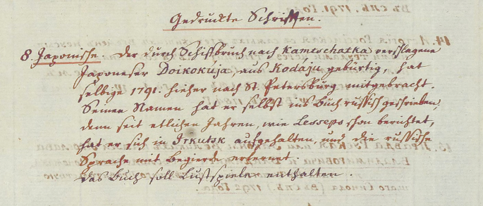
Cod. Ms. Asch 1: 2. Mappe (5) 1793/9. Archivalia (1) 1793 (Bl. 1–37), Blatt 6, Item 8 [Cod. Ms. 151]. Long comment at the bottom of the page referring to Daikokuya Kōdayū’s stay in St. Petersburg in 1791
-
(3)
Items 4 and 5—maps under the shelf-marks Cod. Asch. 285 and 286 and listed only in German. The two maps were drawn in St. Petersburg, sent from there to Göttingen on 3/14 April 1793, and received on 22 June 1793. Both are stamped as “Asch donation” on the verso, and on both are collated extracts from the Asch catalogue of 1894 (see Fig. 12.3).
Fig. 12.3 
(‘Drawn and illuminated personally by the Japanese Doikokùja in St. Petersburg in 1791’)
Cod. Ms. Asch 1: 2. Mappe (5) 1793/9. Archivalia (1) 1793 (Bl. 1–37), Blatt 12 contains a long list of maps, including Chinese and the Japanese items placed at the end. No. 35 Karte von Japon mit Japonischer Schrift. Cod. Asch. 286, ‘Map of Japan with Japanese writing’. No. 36 Karte von Japon mit Russischer und Japonischer Schrift Cod. Asch. 285, ‘Map of Japan with Russian and Japanese writing’. For both it is noted that they are “Vom Japoneser Doikokùja in St. Petersburg AO1791 eigenhändig gezeichnet und illuminert”.
-
(4)
Item 6 (Cod. Ms. Asch 150) [not registered in Asch correspondence]—a letter from Daikokuya Kōdayū on two sheets of paper: the envelope sheet and the sheet with the letter proper written on the recto and verso. In contrast to the maps, the letter is dated only by the cyclical sign of the Pig Year (亥), which mostly corresponds to 1791, an “auspicious day” of its sixth month, that is, about three months later than the maps (亥, 六月吉日). The letter was intended to be sent to Japan with the aim of relating the bitter fate of the writer and his crew, but apparently it never was. On the front of the envelope there is a transcription of Daikokuya Kōdayū’s name in Russian, then in Latin letters, and, below, a note by von Asch that the letter was written by the Japanese man in St. Petersburg in 1791—“von dem Japoneser geschrieben / in St. Petersburg 1791”. It is not clear why the letter is not listed in the Asch correspondence. The only plausible explanation is that it was sent by another means. In addition, the letter does not bear the “Asch donation” stamp, although there is no doubt of its provenance via von Asch. On the back of the envelope, it is noted in German in another hand that the letter was received on 9 August 1793—“erhalten d. 9 Aug. 1793”—presumably in Göttingen. A complete digital copy of the letter is available on the website of the Göttingen Library.Footnote 71
-
(5)
The 7th and last item sent to Göttingen is the earliest map by Daikokuya Kōdayū (Cod. Ms. Asch 284), drawn in Irkutsk in 1789. Like Cod. Ms. Asch 285 and 286, the map is stamped with the “Asch donation” stamp on the verso, and an extract from the printed catalogue of 1894 is collated there. The map has an interesting note in German and Russian on the verso (on the left-hand side): “General Karte von Japan. Aus Irkutsk erhalten. 1793 / Гeнepaльнaя Кapтa Япoнcкaгo Гocyдapcтвa”. The note in German is in von Asch’s hand, so there is no doubt that it was he who received the map. He then sent the map from St. Petersburg on 22 May / 2 June 1794. It was received quite soon—on 14 July 1794. When describing the map in his letter, von Asch again stresses that it was received from Irkutsk (see Fig. 12.4).
Fig. 12.4 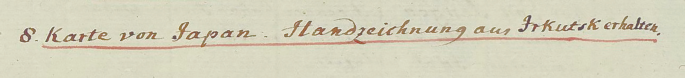
Cod. Ms. Asch 1: II. Mappe (5) 1793/9. Archivalia (2) 1794 (Bl. 38–82), Blatt 42: the list of maps and prospects on recto verso. No 8 Karte von Japan, Handzeichnung aus Irkutsk erhalten (‘map of Japan, manuscript received from Irkutsk’). Cod. Ms. Asch 284


Let us now sum up the acquisition history of Daikokuya Kōdayū’s maps and related items in the Asch Sammlung in relation to his and the Laxmans’ travels during the same period.
This Table (12.2) shows that almost as soon as Daikokuya Kōdayū and the Laxmans departed for the Far East, three maps by Daikokuya Kōdayū as well as his letter and a book he owned were acquired by Georg Thomas von Asch, who sent everything he had to Göttingen shortly thereafter. The last item—the earliest map drawn by Daikokuya Kōdayū (Cod. Ms. Asch. 284)—seems to have been intentionally ordered by him from Irkutsk for this purpose. These items were sent to and reached Göttingen over the course of the years 1792–1794. As far as the dictionaries are concerned, their direct relation to Daikokuya Kōdayū has not been definitively established,Footnote 72 but it seems hardly accidental that both dictionaries were published the year when he and the rest of his crew arrived at Irkutsk. In this case, the fact of their having been sent to St. Petersburg before 1790, when Laxman and the Japanese sailors were still in Irkutsk, is an indication of the effectiveness of the German-speaking community’s connections in Russia.Footnote 73
12.5 Conclusions
Despite all the good will and best intentions of such outstanding persons as Erik Laxman, who strove to work in the best strategic interest of the Russian Empire and encouraged Daikokuya Kōdayū to draw his first map of Japan in Irkutsk, as well as Alexander Bezborodko and Alexander Vorontsov, who urged him to draw more maps during his stay in St. Petersburg, but also the efforts to translate and provide commentaries on these maps, there was minimal response in Russia. Although the maps were meant to serve the interests of the Russian state, as one can see from the role of Bezborodko and Vorontzov in their drawing, and despite the expectation that they would have been collected immediately by state authorities and carefully preserved as documents of state importance, six copies (Cod. Ms. Asch 284, 285, 286, NAE, Hermitage, RGVIA ф451oп1д18) ended up initially in private hands, even if some of the persons involved, such as von Asch and von Krusenstern, occupied official posts. Since the latter was a cartographer himself, the map of Japan included in his Atlas of the Southern Sea is the only case where the maps by Daikokuya Kōdayū might have had a certain influence, and this would indeed be an interesting question to explore. At the same time, this influence would have concerned only the map’s content, as von Krusenstern’s map of Japan is drawn according to Mercator’s projection.Footnote 75
Three of these maps became part of the “curiosities” of the Asch Sammlung, together with some other Japanese and Chinese items collected by von Asch, but at least they were properly accessioned and attributed, and thus potentially available to the academic community from the time of their arrival at Göttingen University Library. It is noteworthy that von Asch received the map drawn in Irkutsk (Cod. Ms. Asch 284) during Erik Laxman’s lifetime and most likely from him, so one can suggest that Laxman was well-disposed towards von Asch’s enterprise of sending the Daikokuya Kōdayū documents to a reliable institution for preservation. As far as we know, the copies left in the Russian Empire were rediscovered only recently, and thus were not in much demand after Daikokuya Kōdayū returned to Japan. One of the factors that could have affected the reception of Daikokuya Kōdayū’s maps is that he drew them during a rather unfavourable time. In the early 1790 s, Catherine the Great was approaching the end of her life and was no longer the shrewd and farsighted political figure she had been in her prime. She and Erik Laxman both died in 1796. The radical change in the government after her death, as well as the disappearance of such an active scholar as Erik Laxman interested in Daikokuya Kōdayū, certainly played a negative role in the proper preservation of these documents in Russia. What is more, Adam Laxman’s expedition was not considered particularly successful.Footnote 76
The main reason these maps were not recognized as documents of state importance and do not seem to have much influence on the mapping of Japan in Russia and in the West is that, despite the attempt to translate these maps through the transcription of toponyms and extensive comments, they remained largely incomprehensible to an audience trained in the modern Western system of cartographic representation. One can conclude that the promising project of having maps of Japan drawn by a native Japanese and translating them proved to be a failure because the system of cartographic representation applied in these maps was too different from what was expected—that is, a map employing cartographic projection and scale and with detailed indications for navigation. None of these are in evidence in the maps by Daikokuya Kōdayū.
When Daikokuya Kōdayū arrived in Russia, knowledge of Japan’s topography was reliant on the map attributed to Jean-Baptiste Tavernier (Paris, 1605—Moscow, July 1689), first printed in 1679 (see Fig. 12.14, Map 10a).Footnote 77 The Russian version of this map was first printed in 1734, and thus became the first map of Japan printed in Russia (see Fig. 12.15, Map 10b).Footnote 78 Comparison of the original French map and its Russian version clearly demonstrates the mechanism of map translation within the modern Western cartographic tradition—the redrawing of the map’s configuration with all its cartometric properties and then the translation of its toponyms and other textual elements as is now the case in contemporary cartography shaped by modern Western cartographic tradition. Daikokuya Kōdayū’s maps provide good evidence that this translation mechanism does not work between two radically different systems of cartographic representation. It is especially noteworthy that Daikokuya Kōdayū took a manuscript version of the Tavernier map in Russian dated 1786—that is, prior to his arrival—along with other sources back to Japan with him. This indicates that, at the time of Daikokuya Kōdayū’s departure from Russia, the Russian authorities apparently still regarded the Tavernier map as the most up-to-date Russian map of Japan.Footnote 79
The Russian authorities who urged Daikokuya Kōdayū to draw maps of Japan naturally expected that, as a native Japanese and a sailor who by definition depended on good command of maps, he would draw a more detailed and accurate map than that by Tavernier, but instead he drew something completely different. The misunderstanding originated on both sides. The Russian authorities educated in modern Western science had a clear idea of what a map should be and believed that translation of the textual parts of any foreign map, with some comments added, if necessary, would make it immediately comprehensible. In the case of Daikokuya Kōdayū’s maps, however, no amount of commentary on the cartographic content could help. In order to make these maps comprehensible, one had to either explain the system of their cartographic representation or try to adapt it to that applied in modern Western cartography. In this case, such adaptation would have meant the radical reconfiguration of the original maps, essentially the drawing of a new map.
Daikokuya Kōdayū, for his part, chose as the most representative image of Japan a schematic map deeply rooted in the autochthonous Japanese cartographic tradition, maybe because it was the only prototype he had in his memory and possibly at hand, or perhaps deliberately in order not to provide too much cartographic information to the foreigners. An argument in favour of the latter supposition is the absence of the strategically important Kanmon Strait between the Honshū and Kyūshū islands in his maps, the existence of which Daikokuya Kōdayū could not have been unaware. Whatever the reason, one can compare Daikokuya Kōdayū’s maps of Japan drawn for the Russian state to a medieval mappaemundi-style map that a Western traveller at the end of the eighteenth century would have drawn for the Japanese authorities as the Western image of the world. It would have been difficult, if not impossible, therefore, to find common cartographic ground, as such a map could only be comprehended in the framework of its own cultural tradition – within the entire set of culturally determined concepts that underlie its system of cartographic representation.

Map 1. Map of Japan by Daikokuya Kōdayū (1789). Irkutsk, the initial map. Recto. Asch Sammlung, Niedersächsische Staats- und Universitätsbibliothek Göttingen. Reproduced courtesy of the SUB Göttingen

Map 2. Map of Japan by Daikokuya Kōdayū (1791). St. Petersburg, model A. Recto. National Archives of Estonia (NAE), Tartu branch. Reproduced courtesy of the NAE

Map 3. Map of Japan by Daikokuya Kōdayū (1791). St. Petersburg, model A. Recto. The State Hermitage, St. Petersburg. Reproduced with permission of the State Hermitage, St. Petersburg

Map 4. Map of Japan by Daikokuya (1791). St. Petersburg, model B. Recto. Asch Sammlung, Niedersächsische Staats- und Universitätsbibliothek Göttingen. Reproduced courtesy of the SUB Göttingen

Map 5. Map of Japan by Daikokuya (1791). St. Petersburg, model B. Recto. Asch Sammlung, Niedersächsische Staats- und Universitätsbibliothek Göttingen. Reproduced courtesy of the SUB Göttingen

Map 6. Map of Japan by Daikokuya (1791). St. Petersburg, model B. Recto. Russian State Archives for Military History (RGVIA), Moscow. Reproduced with permission of the RGVIA

Map 7. Map of Japan by Daikokuya (1791). St. Petersburg, model B. Recto. Russian State Archives for Military History (RGVIA), Moscow. Reproduced with permission of the RGVIA

Map 8. Map of Japan by Daikokuya (1791, St. Petersburg, Model B). Recto, incomplete. Grenville Collection, the Caird Library and Archive of the National Maritime Museum in Greenwich, London. Reproduced with permission of the Caird Library and Archive

Map 9. Dai Nihon koku no zu 大日本國之圖 (Map of the Great Japanese State). Archives of the Research Center for International Japanese Studies, Hosei University 法政大学国際日本学研究所. Recto. Reproduced with permission of the Hosei University

Map 10a. “CARTE DES ISLES DU JAPON esquelles est remarqué la route tant par mer que par terre que tiennent les Hollandois pour se transporter de la ville de Nangasaqui a Iedo, demeure du Roy de ces mesmes Isles”. From: Tavernier (1679).

Map 10b. “Карта островов японских в ней же означен путь яко морем тако и сухим путем его же Голландцы употребляют в приезде своём из града Нагасаки в город Иедо где живет король оных островов”. From: Opisanie o Yapone (1734)
Notes
- 1.
The definition of a map is still one of the most controversial issues in the history of cartographic studies; see a recent lecture by the leading theoretician in the field, Matthew Edney, see Edney (2021), where he challenges the still normative definition of a map proposed in the History of Cartography Project of the Chicago University https://geography.wisc.edu/histcart/. Accessed: 10 March 2021. See Harley and Woodward (1987), pp. XV–XVI.
- 2.
In cases where a lingua franca is used in maps, such as Latin in mediaeval European cartography, or classical Chinese in East Asia, the “national affiliation” of a map is determined by the origins and/or the cartographic school of the map-maker.
- 3.
The dimensions provided here refer to maps proper and not to the sheets on which they appear.
- 4.
For instance, an excellent Russian-Japanese film “Cны o Poccии” (‘Dreams about Russia’) was created about him in 1992. https://www.youtube.com/watch?v=nIOnfiscF4g. Accessed: 10 August 2023.
- 5.
- 6.
Kawakami Jun (1999).
- 7.
- 8.
- 9.
Takigawa Yuko (2022).
- 10.
I am also truly grateful to Hasegawa Masato 長谷川正人 for having called my attention to the studies by Iwai Noriyuki.
- 11.
This date is given in the letter from Daikokuya Kōdayū in the holdings of the Göttingen State and University Library, shelf-mark Cod. Ms. Asch 150, discussed below.
- 12.
According to the letter from Daikokuya Kōdayū, the Japanese sailors reached Amchitka on 6 August 1783.
- 13.
For a digital image of the map and its short descriptions, see https://gdz.sub.uni-goettingen.de/id/PPN349619751; http://kalliope-verbund.info/DE-611-HS-3648813. All accessed: 10 March 2021.
- 14.
Cf., for instance, with the “Asia-America map”, which is thought to have been brought back to Japan by Daikokuya Kōdayū, now in the holdings of the National Archives of Japan (Digital Archives). https://www.digital.archives.go.jp/DAS/pickup/view/detail/detailArchivesEn/0404000000/0000000534/00. Accessed: 10 March 2021. In this map the islands of the Aleutian ridge are considerably oversized and their arrangement has little in common with topographical reality.
- 15.
Lesseps (1790), pp. 203–211.
- 16.
1 versta (вepcтa) is equal to 1.0668 km.
- 17.
Zhurnal posol’stva Laxmana v Yaponiyu / Жypнaл пocoльcтвa Лaкcмaнa в Япoнию (Journal of Laxman’s Embassy to Japan) (1961), covers the period from 13 September 1792 to 21 January 1794. For recent studies of Adam Laxman’s expedition on the basis of his diary, see Kartashov (2017), Shchepkin and Kartashov (2018), Russian version (2017).
- 18.
The maps and other sources are available at the website of the National Archives of Japan. https://www.digital.archives.go.jp/DAS/pickup/view/category/categoryArchives/0400000000/0404000000/00. Accessed: 10 March 2021. Ekaterina Simonova-Gudzenko (2020) questions the assumptions that all the maps were originals. According to Adam Laxman’s diary, some were copied by the Japanese in situ using thin transparent paper, while the Russians kept the originals for themselves, see Zhurnal posol’stva Laxmana v Yaponiyu/Жypнaл пocoльcтвa Лaкcмaнa в Япoнию (Journal of Laxman’s Embassy to Japan) (1961), p. 122 (entry of 15 October 1792). A justification of existence of this copying technique in the late 18th century Russia and Japan in relation to Daikokuya Kōdayū is that one of his maps kept at the Russian Military and Historical Archives –ф451oп1д18—is drawn on the oiled paper meant for copying through superimposition on the original.
- 19.
Outstanding characteristics are marked in bold.
- 20.
All eight maps have recently been digitized in high-resolution (recto-verso). High-resolution copies are not available for open access and have to be ordered from the relevant repository.
- 21.
The acquisition history will be discussed below.
- 22.
- 23.
For the first short report about these two copies, see Kawakami Jun (1999).
- 24.
The archives identify these maps by the file and entry numbers: file 451, entries 18 and 19, respectively, using Cyrillic letters: ф451oп1д18 and ф451oп1д19.
- 25.
Iwai (1999, 2001a, 2001b), see especially table on p. 5. In 1999 and 2000, Iwai refers to the RGVIA maps under the entry numbers 18 and 19 as M1 and M2, respectively, and in 2001 vice versa. I am grateful to Takigawa Yuko for calling my attention to this inconsistency in her email of 12 October 2020, as well for these publications. For the first publication of these maps (recto), see the colour plates in Nemuro rekishi kenkyūkai 根室歴史研究会 (Nemuro History Study Society) (2003).
- 26.
Hasegawa Koji and Kito Yuko (2003).
- 27.
http://www.ra.ee/kaardid/index.php/en/map/view?id=28886. Accessed: 10 March 2021. The website of the NAE is distinguished by especially consistent descriptions of cartographic items.
- 28.
The archives of the von Krusenstern family are located in the Tartu branch of the NAE. One can see the whole list of records in the general archival information system AIS: https://ais.ra.ee/index.php?tyyp=2&module=202&op=21&leidandmed=EAA.1414. Accessed: 10 March 2021; there is a small overview of the von Krusenstern archives (in Estonian only): http://www.eha.ee/fondiloend/frames/fond_prop.php?id=2974. Accessed: 10 March 2021. And several digitized documents are available on the portal of digitized records called Saaga—www.ra.ee/saaga. Accessed: 10 March 2021.—among others the famous travel journals http://www.ra.ee/dgs/explorer.php?tid=173&iid=200000115952&tbn=1&lev=yes&lst=2&hash=cdb11950a9f9a39b731669e964dc7b8e. Accessed: 10 March 2021. I am truly thankful to Maarja Kivi, the archivist of the NAE in Tartu, for this information.
- 29.
Von Krusenstern’s interest in maps of Japan can be seen from a map used in his portrait as an admiral (he became an admiral in 1806)—the ‘Map of Sakhalin’ (Кapтa Caxaлинa), which shows Ezo Island (Hokkaido since 1869). In the map on the portrait it is written in Russian as “Ecco”.
- 30.
- 31.
Bogolyubov (2012), a black and white reproduction of the map is found on pp. 162–163.
- 32.
Sievers’s manuscript Stammbuch (1781–1795) includes a portrait of Daikokuya Kōdayū drawn by Sievers in Irkutsk shortly before Daikokuya Kōdayū’s departure for Japan, as one can see from a short accompanying note: “Mein Freund Kodaju. ein Japanischer SchifsCapitain. reiste wiederum nach Japan. 10. V. 1792. Irkutzk” (‘My friend Kodayu. a Japanese ship captain. travelled back to Japan. 10. V. 1792. Irkutzk’). The Stammbuch was acquired by the Göttingen University Library in 1939 (shelf-mark: 8 Cod. Ms. hist. lit. 48 w). For a short description of it, see https://kalliope-verbund.info/DE-611-HS-3176885. Accessed: 10 March 2021.
- 33.
Bogolyubov (2012), p. 165 does not give the source of this information.
- 34.
- 35.
For instance, in Cod. Ms. Asch 284, one of the northern islands according to the orientation of the map, and the closest to Honsh ū—Sado 佐渡 Island – has the following comment: “нa ceмъ ocтpoвe зoлoтaя cepeбpянaя мeднaя и жeлeзнaя pyды” (‘on this island there are golden[,] silver[,] copper [and] iron ores’).
- 36.
Shelf-mark: GREN1/5 https://images.rmg.co.uk/search/?searchQuery=s9516, reproduced in Takigawa Yuko (2022), p. 188 (map 1).
- 37.
For an overview of geographical issues in the encyclopaedia including references to some maps, see Tatsuoka Yuji 立岡 裕士 (2013).
- 38.
Iwai Noriyuki (1994), pp. 203–206.
- 39.
Unno Kazutaka 海野 一隆 (1999), pp. 144–145.
- 40.
Unno Kazutaka (1999), pp. 128–129; the map from the Nendaiki shin’eshō 年代記新繪抄of 1711 is found on p. 128. We are truly grateful to Takigawa Yuko for having called our attention to Unno’s hypothesis.
- 41.
Tokai setsuyō hyakkatsū (1801), pp. 2b–3a. For its digital images, see https://www2.dhii.jp/nijl/kanzo/iiif/200006409/images/200006409_00005.jpg, https://digital.staatsbibliothek-berlin.de/werkansicht?PPN=PPN3343781630&PHYSID=PHYS_0009&DMDID=DMDLOG_0006. Accessed: 10 March 2021.
- 42.
Dai Nihon koku no zu 大日本國之圖 (Map of the Great Japanese State), Waseda University, shelf-mark: 文庫08 C0986. Undated, monocolour woodblock print on paper; printed in Edo at the printing workshop of Kawachiya Jibei 河内屋治兵; separate map mounted on a decorative sheet for being unrolled and hung on the wall, map sheet: 42.2 cm × 63.2 cm, decorative support sheet: 128.2 cm × 75.4 cm.
https://www.wul.waseda.ac.jp/kotenseki/html/bunko08/bunko08_c0986/index.html. Accessed: 10 March 2021. https://archive.wul.waseda.ac.jp/kosho/bunko08/bunko08_c0986/bunko08_c0986.pdf. Accessed: 10 March 2021.
- 43.
The maps bear the name of the Japanese Buddhist monk Gyōki 行基 (668–749), to whom their creation is ascribed, and are supposed to emulate the shape of vajra. They provide a schematic administrative division of three islands of the Japanese archipelago (Honshū, Kyūshū, and Shikoku). Its sixty-six provinces are arranged into three clusters of ovals or circles stretched along the east–west axis. Each oval or circle contains a province name and the number of its districts. On some maps the seven main roads radiating from the capital province, where Kyoto is situated, are depicted. For an overview of the Gyōki maps, see Unno Kazutaka (1994), pp. 366–371; for a recent study of them, see Simonova-Gudzenko (2019).
- 44.
It is also noteworthy that Iwai (1996b), p. 3, in his list of Daikokuya Kōdayū’s sources, corrected the “wrong” dates of the maps for Kansei 1 (Cod. Ms. Asch 284) and Kansei 3 (Cod. Ms. Asch 285 and 286), respectively.
- 45.
This copy is signed by Daikokuya Kōdayū, but exceptionally does not contain a date by his hand. Since his signature is found at the left edge of the map, and he usually placed the date near his signature, it is possible that the date may eventually have been cut off. The logical identification of “A.Лaкcмaнъ”, found at the lower right corner of the map, as Adam Laxman’s signature can be confirmed to a certain extent by its similarity to the signature of his elder brother Evstafy (Eвcтaфий), see Iwai (1996a), p. 121. Both signatures have similarly written capital letters “Л” (L) in the family name.
- 46.
About ten years ago, in São Paulo, Vera Dorofeeva-Lichtmann discovered a large-format manuscript Japanese world map, currently in safekeeping at the Institute of Brazilian Studies (IEB) of the University of São Paulo. The map was drawn in 1886 by a Japanese person who, like Daikokuya Kōdayū, was not a cartographer but, as can be judged from the handwriting, was well-educated in the Japanese cultural tradition. The map consists of two hemispheres drawn on two separate sheets, each sheet separately dated, the first to the middle decade of the 1st month and the second to the 3rd month with no further details. This gives us a period of time between drawing the first hemisphere and the second, which allows an approximation of how much time it took to draw the first hemisphere—about two to two-and-a-half months. The hemispheres have different dimensions than the maps by Daikokuya Kōdayū, but are close in size, while at the same time being more complex, both in graphics and text. They still provide some basis for comparison. For a preliminary description of this Japanese world map, see Dorofeeva-Lichtmann (2020).
- 47.
To begin with, it is necessary to determine how many persons took part in the transcribing and commenting process. Iwai discusses Daikokuya Kōdayū’s authorship of Russian transcriptions and comments, in particular, see Iwai (1996b), yet the handwriting appears to differ across some maps. The Hermitage copy with German transcriptions and comments is a separate case. In addition, the handwriting of transcriptions and comments seems to differ in some maps. A meticulous analysis of the Russian handwriting of Daikokuya Kōdayū, and the issue of distinguishing between different authors of transcriptions and comments in his maps requires a special study that is beyond the scope of this article.
- 48.
All other Japanese characters can be reliably restored by means of comparison of their surviving elements with dates given by Daikokuya Kōdayū on Cod. Ms. Asch 285 and 286, RGVIA ф451oп1д18 and the copy from the NAE, all drawn in the 3rd month of the 11th year of Tenmei.
- 49.
The comparison of maps by their configuration in addition to their dates was systematically applied by the great historian of Portuguese cartography, Armando Cortesão, see, for instance, Cortesão and Teixeira de Mota (1987), repr. of 1960, vol. III, pp. 55 and 59.
- 50.
If a map is framed by a wide frame, as is the case of the maps by Daikokuya Kōdayū, the “map proper” is measured inside the frame.
- 51.
In this case the slight difference in the dimensions of the “maps proper” is the result of their manuscript production. The copying technique is not clear. Cod. Ms. Asch 286 contains traces of a pencil which was then covered by ink, and Cod. Ms. Asch 285 only ink. Thus the former may first have been roughly sketched in pencil after the latter. An argument in favour of this suggestion is that the contours of Cod. Ms. 286 are rougher than those of Cod. Ms. 285.
- 52.
Vera Dorofeeva-Lichtmann personally inspected and measured Cod. Ms. 284, 285, and 286, RGVIA ф451oп1д18 and ф451oп1д19. Ekaterina Simonova inspected, but could not measure, the map in the Hermitage.
- 53.
In order to determine whether the RGVIA ф451oп1д18 precedes Cod. Ms. Asch 285 and 286 or follows them, one needs to examine its original. Taking into consideration the rather careless signature and date on the map—in contrast to all his other signatures and dates neatly written along vertical lines, the signature and date in RGVIA ф451oп1д18 are curved to the left, as if the author did not care to adopt a convenient writing position, being a bit exhausted by this work. On these grounds we suggest that this map was drawn after Cod. Ms. Asch 285 and 286.
- 54.
- 55.
There are 176 printed volumes and manuscripts and approximately 179 eighteenth-century hand-drawn or printed maps in the library’s Russica and Itineraria collections.
- 56.
https://webarchive.loc.gov/all/20050225214711/http://frontiers.loc.gov/intldl/mtfhtml/mfsplash.html. Accessed: 10 March 2021.
- 57.
http://frontiers.loc.gov/intldl/mtfhtml/mfdigcol/subcoll.html. Accessed: 10 March 2021. The maps are listed alphabetically.
- 58.
Hauser-Schäublin and Krüger (2007).
- 59.
Both maps are placed on the endpapers; front: the map of Siberia relevant to the First Kamchatka expedition (1725–1730) with depictions of the Siberian peoples (1729, Cod. Ms. Asch 246; for a digital image of the map, see https://gdz.sub.uni-goettingen.de/id/PPN349593140. Accessed: 10 March 2021. For a short description, see https://kalliope-verbund.info/DE-611-HS-3640298. Accessed: 10 March 2021. Back: the perspective map of the Russian-Chinese border around Kyachta and Naimachin (eighteenth century, Cod. Ms. Asch 269; for a short description, see https://kalliope-verbund.info/DE-611-HS-3651070). Accessed: 10 March 2021. They are among the most famous cartographic items in the Asch Sammlung.
- 60.
http://asch.wiki.gwdg.de/index.php/Main_Page. Accessed: 10 March 2021.
http://www.sub.uni-goettingen.de/projekte-forschung/projektdetails/projekt/asch/. Accessed: 10 March 2021.
- 61.
Some lists and annotations exist in two copies, as von Asch sent one copy to Heyne separately, and one enclosed with the donations.
- 62.
For the Asch correspondence, see https://gdz.sub.uni-goettingen.de/collection/aschiana. Accessed: 10 March 2021. The Asch correspondence bears the shelf-mark Cod. Ms. Asch 1: 1 and 2, and is arranged in six files according to the years when they were received.
- 63.
Manuscript catalogues bear the Shelf-mark Bibl. Arch. Kataloge 0.
- 64.
Verzeichniss der Handschriften im Preussischen Staate. I—Hannover—3, Göttingen 3. (1894).
- 65.
A brief survey of Daikokuya Kōdayū-related items at the Göttingen University Library was drawn up by Rohlfing (2003), pp. 293–295.
- 66.
These two documents were completely digitized in 2020 thanks to an order from the MPIWG (Berlin).
- 67.
After several blank pages following the title of Cod. Ms. Asch 148 there is an added inscription in French “Dictionnaire de la langue Monsurienne ou Manchour dans le Thibet”.
- 68.
Hereafter in all cases where von Asch gives two dates we adhere to his double dating system.
- 69.
The dictionaries are written on different types of paper, but the sheets about the first quarter of Cod. Ms. Asch 149 seem to be of the same batch as those used for the map Cod. Ms. Asch 284, as is the letter by Daikokuya Kōdayū (Cod. Ms. 150) written in St. Petersburg and discussed below. Examining the quality and the origins of paper may provide some additional information for studying the circulation of the manuscripts by Daikokuya Kōdayū.
- 70.
https://kalliope-verbund.info/DE-611-HS-3206922. Accessed: 10 March 2021. This book contains a library card with notes concerning photo orders dated 11 December 1929 for Martin Ramming, the author of the earliest monograph study on Daikokuya Kōdayū in a Western language, see Ramming (1931).
- 71.
For complete digital images of the letter, see https://gdz.sub.uni-goettingen.de/id/PPN349566488. Accessed: 10 March 2021; https://gdz.sub.uni-goettingen.de/id/PPN349566488. Accessed: 10 March 2021. See also short annotations of this document https://kalliope-verbund.info/DE-611-HS-3206921. Accessed: 10 March 2021; http://hdl.loc.gov/loc.ndlpcoop/mtfxtx.g349566488. Accessed: 10 March 2021. For its Russian translation, see Konstantinov (1961), also available on the Bocтoчнaя Литepaтypa (Oriental Literature) website. http://www.vostlit.info/Texts/Dokumenty/Japan/XVIII/1780-1800/Kodaj_Dajkokuj/text1.htm. Accessed: 10 March 2021.
- 72.
Iwai (1996b), pp. 3–4 does not include these dictionaries in his list of Daikokuya Kōdayū’s manuscripts.
- 73.
The members of the German-speaking community in Russia—a community for whom German was one of the main working languages and to which Laxman, von Asch, and von Krusenstern all belonged—maintained extensive connections with one another as well as strong connections with German-speaking Europe.
- 74.
https://gdz.sub.uni-goettingen.de/id/PPN349563675. Accessed: 10 March 2021.
- 75.
Both von Asch and von Krusenstern were members of the Göttingen Academy of Sciences, and since von Krusenstern was von Asch’s younger contemporary, it is highly plausible that von Krusenstern knew about the maps sent by von Asch to Göttingen.
- 76.
The important result of this expedition—permission for the Russian Empire to send one ship per year to Nagasaki during the period of isolation of Japan—was completely missed at the Russian court. By way of comparison, such an old trading partner of Japan as Holland was entitled to only two ships per year. Erik Laxman applied in vain for state awards for the participants of the first Russian embassy to Japan and tried to organize the second, but the next Russian embassy to Japan—headed by Nikolai Petrovich Rezanov (Hикoлaй Пeтpoвич Peзaнoв; St. Petersburg, 1764—Krasnoyarsk, 1807)—did not take place until 1803, following a change in the Russian government.
- 77.
The map entitled Carte des isles du Japon esquelles est remarqué la route tant par mer que par terre que tiennent les Hollandois pour se transporter de la ville de Nangasaqui a Iedo, demeure du Roy de ces mesmes Isles was published in Tavernier in 1679. It was engraved by Jean-Louis Durant (Orleans, 1654—Geneva, 1718) after a drawing by Jean-Baptiste Tavernier (Paris, 1605—Moscow, 1689). For general information about this map, see Walter (1994), plate 35.
- 78.
The map was published in the Opisanie o Yapone (1734).
- 79.
A digitized image of this map is provided on the website of the National Archives of Japan under the title Kōchō yochi zenzu 皇朝輿地全図 (Map covering the entire [surface] of the lands of the August Dynasty [i.e., of Japan]).
). Its Russian title is “Кapтa Ocтpoвoв Япoнcкиx…” (Map of the Japanese Islands), and it is transcribed the other way round—the original Russian toponyms are transcribed into the Japanese.
https://www.digital.archives.go.jp/DAS/pickup/view/category/categoryArchives/0400000000/0404000000/00. Accessed: 10 March 2021. https://www.digital.archives.go.jp/DAS/pickup/view/detail/detailArchivesEn/0404000000/0000000538/00. Accessed: 10 March 2021. For a study of this map in relation to the original map by Tavernier, see Iwai (1995).
Bibliography
Sources
de Lesseps, Barthélemy. 1790. Journal historique du voyage de M. de Lesseps, vol. 1. Paris: Moutard. https://gallica.bnf.fr/ark:/12148/bpt6k1040345w.image; https://gdz.sub.uni-goettingen.de/id/PPN332423298. Accessed: 10 March 2021.
Konstantinov, Vladimir M. (Кoнcтaнтинoв, Bлaдимиp M.). 1961. Pis’mo Daikokuya Kodayu iz Rossii v Yaponiyu / Пиcьмo Дaйкoкyя Кoдaю из Poccии в Япoнию (The letter of Daikokuya Kōdayū from Russia to Japan). Kitai. Yaponiya. Istoriya i filologiya / Китaй. Япoния. Иcтopия и филoлoгия (China, Japan. History and philology), 200–205. Moscow: Vostochnaya Literatura. http://www.vostlit.info/Texts/Dokumenty/Japan/XVIII/1780-1800/Kodaj_Dajkokuj/text1.htm. Accessed: 10 March 2021.
Map 1. Map of Japan by Daikokuya Kōdayū (1789). Irkutsk, the initial map. Asch Sammlung, Niedersächsische Staats- und Universitätsbibliothek Göttingen. Shelf-mark: Cod. Ms. Asch 284. Coloured manuscript. Sheet: 66.0 cm x 127.0 cm; map proper: 62.8 cm (left/right) x 124.2 cm (bottom), 125.0 cm (top) (measurements by Vera Dorofeeva-Lichtmann).
Map 2. Map of Japan by Daikokuya Kōdayū (1791). St. Petersburg, model A. National Archives of Estonia (NAE), Tartu branch. Shelf-mark: EAA.1414.2.43 sheet 64. Coloured manuscript. Sheet: 75.0 cm x 149.0 cm (measurements provided by the NAE); approximated map proper: ca. 73.0 cm x 148.0 cm.
Map 3. Map of Japan by Daikokuya Kōdayū (1791). St. Petersburg, model A. The State Hermitage, St. Petersburg. Shelf-mark: BФcэ-363. Coloured manuscript. Sheet: 74.5 cm x 148.0 cm (measurements provided by the State Hermitage); approximated map proper: ca. 73.0 cm x 147.0 cm.
Map 4. Map of Japan by Daikokuya (1791). St. Petersburg, model B. Asch Sammlung, Niedersächsische Staats- und Universitätsbibliothek Göttingen. Shelf-mark: Ms. Asch 285. Coloured manuscript. Sheet: 65.0 cm x 138.0 cm; map proper: 60.0 cm (left/right) x 119.0 cm (bottom), 117.0 cm (top) (measurements by Vera Dorofeeva-Lichtmann).
Map 5. Map of Japan by Daikokuya (1791). St. Petersburg, model B. Asch Sammlung, Niedersächsische Staats- und Universitätsbibliothek Göttingen. Shelf-mark: Cod. Ms. Asch 286. Coloured manuscript. Sheet: 66.0 cm x 124.0 cm; map proper: 60.0 cm (left/right) x 117.7 cm (bottom), 118.0 cm (top) (measurements by Vera Dorofeeva-Lichtmann).
Map 6. Map of Japan by Daikokuya (1791). St. Petersburg, model B. Russian State Archives for Military History (RGVIA), Moscow. Shelf-mark: ф451oп1д18. Sheet: 63.2 (left), 62.2 (right) x 122.8 (bottom) 122.9 (top) (cf. catalogue RGVIA F. 451: 62 x 120); map proper: 59.8 (left) 61.0 (right) x 120.5 (bottom, very uneven), 120.1 (top) (measurements by Vera Dorofeeva-Lichtmann).
Map 7. Map of Japan by Daikokuya (1791). St. Petersburg, model B. Russian State Archives for Military History (RGVIA), Moscow. Shelf-mark: ф451oп1д19. Coloured manuscript. Sheet: 67.4 (left/right) x 126.7 (bottom), 125.6 (top) (cf. Iwai 2001, p. 5: 62 x 126); map proper: 62.0 (left), 60.0 (right) x 120.5 (bottom), 118.8.
Map 8. Map of Japan by Daikokuya (1791), St. Petersburg, Model B. Incomplete Grenville Collection, the Caird Library and Archive of the National Maritime Museum in Greenwich, London Shelf-mark : GREN1/5 Map sheet: 65.0 x 123.5 cm, approximated map proper: ca. 60.0 x 120.0 cm.
Map 9. Dai Nihon koku no zu 大日本國之圖 (Map of the Great Japanese State). Archives of the Research Center for International Japanese Studies, Hosei University 法政大学国際日本学研究所. Shelf-mark: 分類 [Category] I 日本のかたち・世界のかたち [Shapes of Japan and the world], No. 1004. Undated, monocolour woodblock print on paper; separate map. Printed in Edo at the printing workshop of Kawachiya Jihei 河内屋治兵衛. Map sheet: ca. 47,0 cm x ca. 65,5 cm. Oriented with the South on top.
Map 10a. “CARTE DES ISLES DU JAPON esquelles est remarqué la route tant par mer que par terre que tiennent les Hollandois pour se transporter de la ville de Nangasaqui a Iedo, demeure du Roy de ces mesmes Isles”. From: Recüeil de plusieurs relations et traitez singuliers et curieux de J.B. Tavernier, Paris, Chez Gervais Couzier, 1679; inserted after the title sheet of Part I. “Relation du Japon et de la cause de la persecution contre les Chrestiens dans les Isles”. 51,5 cm x 76,5 cm, monocoulour copper print. Engraved by Jean-Louis Durant (Orleans, 1654 – Geneva, 1718). After a drawing by Jean-Baptiste Tavernier (Paris, 1605 – Moscow, 1689).
Map 10b. “Кapтa ocтpoвoв япoнcкиx в нeй жe oзнaчeн пyть якo мopeм тaкo и cyxим пyтeм eгo жe Гoллaндцы yпoтpeбляют в пpиeздe cвoём из гpaдa Haгacaки в гopoд Иeдo гдe живeт кopoль oныx ocтpoвoв”. From: Opisanie o Yapone 1734.
Opisanie o Yapone. 1734. Opisanie o Yapone: Soderzhashchee v sebe tri chasti, to est’: Izvestie o Yapone i o vine goneniya na khristian, Istoriyu o gonenii christian v Yapone i Posledovanie stranstviya Genrika Gagenara, kotoroe ispravnoyu landkartoyu i izryadnymi figurami ukrasheno/ / Oпиcaниe o Япoнe: Coдepжaщee в ceбe тpи чacти, тo ecть: Извecтиe o Япoнe и o винe гoнeния нa xpиcтиaн, Иcтopию o гoнeнии xpиcтиaн в Япoнe и Пocлeдoвaниe cтpaнcтвoвaния Гeнpикa Гaгeнapa, кoтopoe иcпpaвнoю лaндкapтoю и изpядными фигypaми yкpaшeнo (Description of Japan: Containing three parts, namely: News about Japan and about the blame of persecusion of Christians, History of persecution of Christians in Japan and Report of travels of Henri Hagenaar, decorated by an up-to-date map and many illustrations). Sankt-Petersburg: Academy of Sciences (translation of three works: 1. J. B. Tavernier. Relation du Japon, et de la cause de la persécution contre les chéstiens dans les isles. 2. R. Gijsbertsz. Histoire d’une persécution qui a été faite aux chrétiens romains du Japon. 3. Suite du voyage de Henri Hagenaar, aux Indes Orientales. Description de l’Empire du Japon, faite par François Caron ... et augmentée de quelques remarques de Henri Hagenaar).
Tavernier, Jean-Baptiste. 1679. Recüeil de plusieurs relations et traitez singuliers et curieux de J.B. Tavernier. Paris : Chez Gervais Clouzier. https://gallica.bnf.fr/ark:/12148/bpt6k85327p. Accessed: 10 March 2021.
Verzeichniss der Handschriften im Preussischen Staate. I – Hannover – 3, Göttingen 3. 1894. Berlin: Verlag von A. Bath. [ASCH: 22–75].
Zhurnal posol’stva Laxmana v Yaponiyu / Жypнaл пocoльcтвa Лaкcмaнa в Япoнию (Journal of Laxman’s Embassy to Japan). 1961. Istorichesky Archiv/Иcтopичecкий apxив – Historical Archives 4: 117–146.
Research Literature
Bogolyubov (Бoгoлюбoв) A.M. 2014. Karta Yaponii Daikokuya Kodayu / Кapтa Япoнии Дaйкoкyя Кoдaю” (Map of Japan by Daikokuya Kōdayū). Trudy Gosudarstvennogo Ermitazha, vol. 72: Ermitazhnye chteniya pamyati V.G. Lukonina (21.01.1932–10.09.1984). K 80-iyu so dnya rozhdeniya. 2007–2012. Godudarstvenny Ermitazh / Tpyды Гocyдapcтвeннoгo Эpмитaжa, тoм 72: Эpмитaжныe чтeния пaмяти B.Г. Лyкoнинa (21.01.1932–10.09.1984). К 80-ию co дня poждeния. 2007–2012. Гocyдapcтвeнный Эpмитaж (Studies of the State Hermitage 72: The Hermitage readings in the memory of V.G. Lukonin (21.01.1932–10.09.1984). To his 80th anniversary. 2007–2012. The State Hermitage), 161–165. Petersburg: The State Hermitage Press. (Partial Japanese translation: Arekusei Bogoryubofuアレクセイ・ボゴリュボフ. 2016. Nichiro kankei kenkyūshiryo to shite no Erumitāju kokuritsu bijutsukan no nihon geijutsu korekushon 日露関係研究資料としてのエルミタージュ国立美術館の日本芸術コレクション (The Japanese Art Collection of the Hermitage National Art Museum as a research material about Russian and Japanese relations, transl. Arakawa Yoshiko 荒川好子). Senshu Daigaku Junbun Kagaku Kenkyujo Geppō専修大学人文科学研究所月報 / Senshu University Institute of Humanities Monthly Bulletin 28: 1–11).
Buchholz, Arnold. 1961. Die Göttinger Rußlandsammlungen Georgs von Asch. Ein Museum der russischen Wissenschaftsgeschichte des 18. Jahrhunderts. Gießen: Schmitz.
Cortesão, Armando, and Avelino Teixeira da Mota. 1987 [repr. 1960–1962]. Portugaliae monumenta cartographica, 6 vols. Lisbon: Imprensa Nacional – Casa da Moeda. (Comissão Executiva das Comemorações do V Centenario da Morte do Infante D. Henrique).
Dorofeeva-Lichtmann, Vera V. 2020. A Manuscript Japanese World Map (1886) from the Banco Santos Collection (São Paulo, Brazil): De-centred Ways of Knowledge Transmission. In Rotas, mapas & intercâmbios da História da Ciência, eds. Ana-Maria Alfonso-Goldfarb, José-Luiz Goldfarb, Márcia H. M. Ferraz, Silvia I. Waisse, and Luciana Costa Thomaz, 25–45. São Paulo: EDUC.
Edney, Matthew. 2021. What the *Bleep* Are Maps? Trying to Write the History of Cartography, lecture delivered at the Osher Map Library and Smith Center for Cartographic Education, 29.11.2021, https://youtu.be/l_NOO-vgvBM. Accessed: 10 March 2021.
Harley, J.B., and David Woodward. 1987. Preface. In Cartography in Prehistoric, Ancient, and Medieval Europe and the Mediterranean, The History of Cartography, vol. 1, eds. J. B. Harley, and David Woodward, XV–XXI. Chicago – London: The University of Chicago Press. http://www.press.uchicago.edu/books/HOC. Accessed: 10 March 2021.
Hasegawa Koji 長谷川 孝治 and Kita Yuko 喜多 祐子. 2003. Hyōryū-min no kokudo byōsha – shin hakken no Daikokuya Kōdayū Nihon zu wo megutte漂流民の国土描写 – 新発見の大黒屋光太夫日本図を巡って– / The depiction of the country of the drifted people: Newly discovered map of Japan by Kohdayu. 日本地理学会発表要旨集 / Proceedings of the General Meeting of the Association of Japanese Geographers 63: 172.
Hasegawa Koji 長谷川 孝治. 2013. Nostalgia in Maps [poster abstract]. The 25th International Conference on the History of Cartography (Abstracts), Helsinki, Finland, 30 June – 5 July 2013, 131.
Hauser-Schäublin, Brigitta, and Gundolf Krüger (eds.). 2007. Sibirien und Russisch-Amerika: Kultur und Kunst des 18. Jahrhunderts; die Sammlung von Asch, Göttingen/Siberia and Russian America: culture and art from the 1700s; the Asch collection, Göttingen. München, New York: Prestel.
Iwai Noriyuki 岩井 憲幸. 1994. Getchingen daigaku zō: Daikokuya Kōdayū hitsu Nihon zu ni tsuite shoshigakuteki bunken-gaku-teki ichi kenkyū ゲッチンゲン大学蔵 : 大黒屋光太夫筆日本図について 書誌学的 ・文献学的一研究” (University of Göttingen Collection: Study of bibliography and manuscripts of the maps of Japan drawn by Daikokuya Kōdayū). Meiji daigaku kyōyō ronshū (Meiji daigaku kyōyō ronshū kankō-kai) 明治大学教養論集 (明治大学教養論集刊行会) / The Bulletin of Arts and Sciences, Meiji University 269(12): 153–215.
Iwai Noriyuki岩井 憲幸. 1995. Kōchō yochizenzu’ to ‘Nihonshi’ shoshū Nihon zu ni tsuite – genzu wo motomete – 皇朝輿地全図と『日本史』所収日本図について – 原図を求めて – (The General Map of Japan in Katsuragawa’s Hokusa-Bunryaku and its Presumed Original). Meiji daigaku kyōyō ronshū (Meiji daigaku kyōyō ronshū kankō-kai) 明治大学教養論集 (明治大学教養論集刊行会) / The Bulletin of Arts and Sciences, Meiji University 280: 51–83.
Iwai Noriyuki 岩井 憲幸 1996a. Daikokuya Kōdayū shoseki shiryō ichiran fu sankō shashin 大黒屋光太夫書蹟資料一覧 附参考写真 (List of the Manuscripts of Daikokuya Kōdayū with references, photos). Meiji daigaku kyōyō ronshū (Meiji daigaku kyōyō ronshū kankō-kai) 明治大学教養論集 (明治大学教養論集刊行会) / The Bulletin of Arts and Sciences, Meiji University 292(9): 81–146.
Iwai Noriyuki 岩井 憲幸. 1996b. Daikokuya Kōdayū shoseki shiryō no gogaku-teki sokumen 大黒屋光太夫書蹟資料の語学的側面/Observations on the Handwriting and Manuscripts of Daikokuya Kodayu. Meiji daigaku jinbunkagaku kenkyujo kiyo 明治大学人文科学研究所紀要/ The Bulletin of Institute of Humanities, Meiji University 40: 297–315.
Iwai Noriyuki 岩井 憲幸. 1999. Kōdayū no shomei – Roshia gunji rekishi komonjo-kan shozō Kōdayū hitsu Nihon chizu hakken ni yosete – 光太夫の署名 – ロシア軍事歴史古文書館所蔵光太夫筆日本地図発見によせて – (Kōdayū’s Signature: discovery of Japanese maps by Kōdayū held in the Russian State Military History Archives). Chiiki-shi kenkyū Hakodate地域史研究はこだて(Hakodate Regional History Research) (Hakodate-shi-shi-hen-san-shitsu函館市史編さん室 [Hakodate City Historiographical Office]) 30: 78–87.
Iwai Noriyuki岩井 憲幸. 2001. Shinshutsu no Daikokuya Kōdayū hitsu Nihon zu ni tsuite 新出の大黒屋光太夫筆日本図について (Newly found maps of Japan drawn by Daikokuya Kōdayū). Meiji daigaku kyōyō ronshū (Meiji daigaku kyōyō ronshū kankō-kai) 明治大学教養論集 (明治大学教養論集刊行会) / The Bulletin of Arts and Sciences, Meiji University 328(1): 101–128.
Iwai Noriyuki岩井 憲幸. 2001. Kōdayū no Nihon zu 光太夫の日本図. 大黒屋光太夫顕彰会 (Maps of Japan drawn by Daikokuya Kōdayū). Daikokuya Kōdayū kenshō-kai 大黒屋光太夫顕彰会 (Daikokuya Kōdayū Honoring Society) 9. Suzuka: Mie.
Kartashov Kirill M. 2017. Zhurnal russkoi ekspeditsii v Yaponiyu, s prilozheniem perepiski komandira ekspeditsii s beregovymi vlastnami o razreshenii vkhodit’ v yaponskie gavani i vysadki ekipazha na bereg kak istochnik po ekspeditsii A.K.Laksmana (1792–1793) / Жypнaл pyccкoй экcпeдиции в Япoнию, c пpилoжeниeм пepeпиcки кoмaндиpa экcпeдиции c бepeгoвыми влacтями o paзpeшeнии вxoдить в япoнcкиe гaвaни и выcaдки экипaжa нa бepeг“ кaк иcтoчник пo экcпeдиции A.К.Лaкcмaнa (1792–1793) (English abstract: “The Journal of the Russian Expedition to Japan with the Attachment of the Correspondence between the Head of the Expedition and the Coastal Authorities concerning the Permission to Enter Japanese Ports and Disembark the Crew” as a Primary Source on Adam Laxman’s Expedition (1792–1793)) Yaponskie issledovaniya/Япoнcкиe иccлeдoвaния (Japanese studies) 2017.4: 50–61.
Kawakami Jun 川上 淳. 1999. Roshia gunji rekishi komonjo-kan kara hakken sareta Daikokuya Kōdayū hitsu Nihon zu ni-mai ロシア軍事歴史古文書館から発見された大黒屋光太夫筆日本図二枚 (Two maps of Japan drawn by Daikokuya Kōdayū found in the Russian State Military Archive). Mado窓 (Window) 110: 22–26.
Nemuro rekishi kenkyūkai根室歴史研究会 (Nemuro History Study Society). 2003. Rakusuman no Nemuro raikō ラクスマンの根室来航 (Laxman’s visit to Nemuro). Nemuro: Nemuro-shi hakubutsukan kaisetsu junbi-shitsu根室市博物館開設準備室 (Preparative Office of Nemuro Municipal Museum).
Ramming, Martin. 1931. Reisen schiffbrüchiger Japaner im XVIII. Jahrhundert. Berlin: Würfel Verlag.
Rohlfing, Helmut. 1998. „ganz vorzügliche und unvergeßliche Verdienste“: Georg Thomas von Asch als Förderer der Universität Göttingen. Katalog einer Ausstellung im Historischen Gebäude der Niedersächsischen Staats- und Universitätsbibliothek, 20. April bis 22. Mai 1998. Göttingen: Niedersächsische Staats- und Universitätsbibliothek.
Rohlfing, Helmut. 2003. Eine neue russische Bibliothek in Göttingen: Georg Thomas von Asch als Förderer der Georgia Augusta. In Russland und die „Göttingische Seele“: 300 Jahre St. Petersburg, eds. Elmar Mittler, and Silke Glitsch, 287–302. Göttingen: Göttinger Bibliotheksschriften.
Shchepkin, Vassily V., and Kirill M. Kartashov. 2018. “Ritual and Law”: Reception of Adam Laxman’s expedition in Japan. Russian Japanology Review 2018(1): 149–158. https://www.japanreview.ru/jour/issue/view/9. For its original Russian version, see Щeпкин Bacилий B. и Киpилл M. Кapтaшoв. Pитyaл и зaкoн: пpиeм экcпeдиции A. Лaкcмaнa в Япoнии. Япoния 2017. Eжeгoдник: 169–180. https://www.yearbookjapan.ru/jour/issue/view/17. Accessed: 16 December 2023.
Simonova-Gudzenko, Ekaterina K. 2019. Gyōki-Type Shape: Representation of the Japanese Archipelago in East-Asian and Western Maps. In Mapping Asia: Cartographic Encounters between East and West. Regional Symposium of the ICA Commission on the History of Cartography, 2017, eds. Martijn Storms, Mario Cams, Imre Josef Demhardt, and Ferjan Ormeling, 125–146. Berlin: Springer.
Simonova-Gudzenko, Ekaterina K. (Cимoнoвa-Гyдзeнкo, Eкaтepинa К.). 2020. Pervaya russkaya ekspeditsiya v Yaponiyu 1792 g. i geograficheskie karty/Пepвaя pyccкaя экcпeдиция в Япoнию 1792 г. и гeoгpaфичecкиe кapты. (The First Russian Expedition in Japan 1792 and Geographical maps). JAPAN XXI NOVA: эpa и вeк. Boпpocы япoнoвeдeния/JAPAN XXI NOVA: era i vek. Voprosy yaponovedeniy (JAPAN XXI NOVA: era and century. Issues of Japanology) 8: 144–153.
Takegawa Yuko 滝川 祐子. 2022. “Shinshutsu no Igirisu shiryō kara mita jūhasseiki-matsu no Seiou ni okeru Daikokuya Kōdayū Nihon-zu no hyōka” 新出の英国史料からみた十八世紀末の 西欧における大黒屋光太夫日本図の評価/The 18th Century Map of Japan by Daikokuya Kōdayū: On the 1793 Whitworth Copy Recently Discovered in Greenwich, UK (abstract).” Nihon kenkyū日本研究 64: 159–197.
Tatsuoka Yuji 立岡 裕士. 2013. Kinsei setsuyoshu ni okeru [chiri] no keishutsu jōkyō 立岡裕士 近世節用集における「地理」の掲出状況” (Geography [chiri] in premodern [Japanese popular encyclopedia] setsuyoshu). Research Bulletin of Naruto University of Education/鳴門教育大学研究紀要 28: 356–367.
Tokai setsuyō hyakkatsū. 1801. Tokai setsuyō hyakkatsū都会節用百家通 (Complete Compendium of Urban Knowledge). Osaka: Torikae Ochizaemon鳥飼市左衛門. https://digital.staatsbibliothek-berlin.de/werkansicht?PPN=PPN3343781630&PHYSID=PHYS_0001&DMDID=. Accessed: 10 March 2021.
Unno Kazutaka. 1994. Cartography in Japan. In The History of Cartography, vol. II.2: Cartography in the Traditional East and Southeast Asian Societies, eds. John B. Harley, and David Woodward, 346–477. Chicago, London: The University of Chicago Press.
Unno Kazutaka 海野 一隆. 1999. Chizu ni miru Nihon – Wakoku, Zipangu and Dai Nippon 地図に見る日本 – 倭国・ジパング・大日本 – (Japan as was depicted in maps: Wakoku, Zipangu and Dai Nippon). Tokyo: Taishukan shoten大修館書店.
Walter, Lutz (ed.). 1994. Japan: A Cartographic Vision. European Printed Maps from the Early 16th to the 19th Century. Munich, New York: Prestel.
Walter, Lutz (ed.). 1994. Japan mit den Augen des Westens gesehen: Gedruckte europäische Landkarten vom frühen 16. bis zum 19. Jahrhundert. München, New York: Prestel.
Author information
Authors and Affiliations
Corresponding author
Editor information
Editors and Affiliations
Rights and permissions
Open Access Dieses Kapitel wird unter der Creative Commons Namensnennung 4.0 International Lizenz (http://creativecommons.org/licenses/by/4.0/deed.de) veröffentlicht, welche die Nutzung, Vervielfältigung, Bearbeitung, Verbreitung und Wiedergabe in jeglichem Medium und Format erlaubt, sofern Sie den/die ursprünglichen Autor(en) und die Quelle ordnungsgemäß nennen, einen Link zur Creative Commons Lizenz beifügen und angeben, ob Änderungen vorgenommen wurden.
Die in diesem Kapitel enthaltenen Bilder und sonstiges Drittmaterial unterliegen ebenfalls der genannten Creative Commons Lizenz, sofern sich aus der Abbildungslegende nichts anderes ergibt. Sofern das betreffende Material nicht unter der genannten Creative Commons Lizenz steht und die betreffende Handlung nicht nach gesetzlichen Vorschriften erlaubt ist, ist für die oben aufgeführten Weiterverwendungen des Materials die Einwilligung des jeweiligen Rechteinhabers einzuholen.
Copyright information
© 2024 Der/die Autor(en)
About this chapter

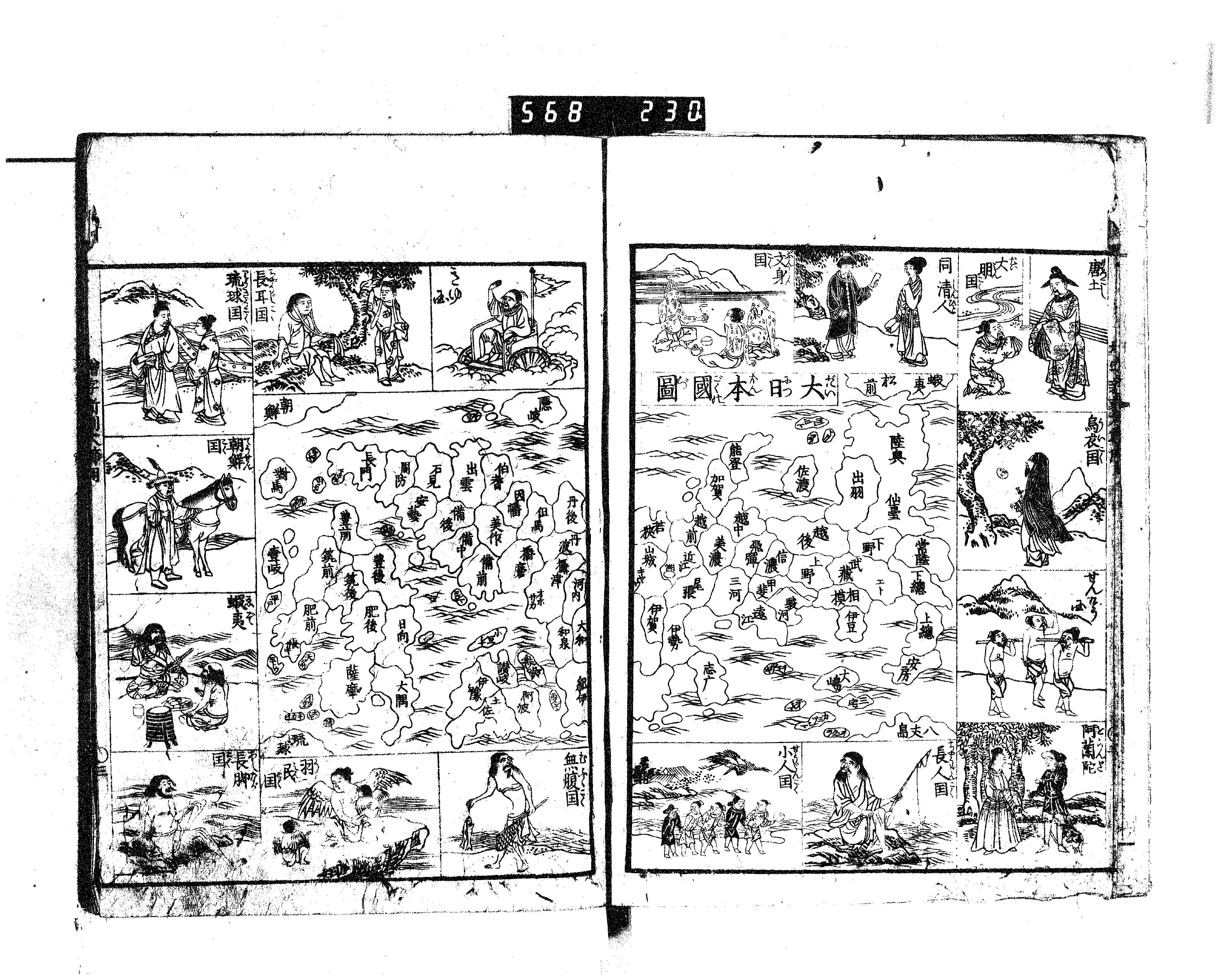
Cite this chapter
Dorofeeva-Lichtmann, V., Simonova-Gudzenko, E. (2024). Lost in Transmission. Maps of Japan by Daikokuya Kōdayū 大黒屋 光太夫 (1751–1828)*. In: Flüchter, A., Gipper, A., Greilich, S., Lüsebrink, HJ. (eds) Übersetzungspolitiken in der Frühen Neuzeit / Translation Policy and the Politics of Translation in the Early Modern Period. Übersetzungskulturen der Frühen Neuzeit, vol 3. J.B. Metzler, Berlin, Heidelberg. https://doi.org/10.1007/978-3-662-67339-3_12
Download citation
DOI: https://doi.org/10.1007/978-3-662-67339-3_12
Published:
Publisher Name: J.B. Metzler, Berlin, Heidelberg
Print ISBN: 978-3-662-67338-6
Online ISBN: 978-3-662-67339-3
eBook Packages: J.B. Metzler Humanities (German Language)