
Zusammenfassung
In der Kartographie gilt das Thema Tourismus als etabliertes Anwendungsfeld zur Erstellung kartographischer Medien. Die Funktionen touristischer Karten können dabei sehr unterschiedlich sein und sind zudem stark vom Nutzungskontext abhängig. In diesem Beitrag wird zwischen kartographischen Medien zur Orientierung und Navigation, beschreibenden bzw. analytischen kartographische Medien sowie steuernden kartographische Medien differenziert. Zudem ergibt sich – je nach Anwendungskontext – auch eine Funktionshybridität. Anhand von Beispielen werden die genannten Funktionen vorgestellt und diskutiert. In einer Schlussbetrachtung wird die Funktionshybridität, auch vor dem Hintergrund aktueller 3D-Visualisierungstechniken (Virtual Reality) aufgegriffen und diskutiert.
Access this chapter
Tax calculation will be finalised at checkout
Purchases are for personal use only
Literatur
Banis, D., & Shobe, H. (2015). Portlandness. A cultural atlas. Sasquatch Books.
Bertin, J. (1967). Sémiologie graphique. Les diagrammes. Les réseaux. Les cartes. Gauthier-Villars.
Bestgen, A.-K., Edler, D., Müller, C., Schulze, P., Dickmann, F., & Kuchinke, L. (2017). Where Is It (in the Map)? Recall and Recognition of Spatial Information. Cartographica, 52, (1,S. 80–97). https://doi.org/10.3138/cart.52.1.3636.
Bollmann, J., & Koch, W.G. (Hrsg.). (2002).Lexikon der Kartographie und Geomatik. Karto – Z (Bd 2), Spektrum.
Brokou, D., Darra, A., & Kavouras, M. (2021). The new role of cartography in modern tourism. AGILE: GIScience series, 2, Proceedings of the 24th AGILE Conference on Geographic Information Science (19, S. 1–11). https://doi.org/10.5194/agile-giss-2-19-2021.
Cherep, L. A., Lim, A. F., Kelly, J. W., Acharya, D., Velasco, A., Bustamante, E., Ostrander, A. G., & Gilbert, S. B. (2020). Spatial cognitive implications of teleporting through virtual environments. Journal of Experimental Psychology: Applied, 26, (3, S. 480–492). https://doi.org/10.1037/xap0000263.
Clarke, L. M. (1989). An experimental investigation of communicative efficiency of point symbols on tourist maps. The Cartographic Journal, 26, (2, S. 105–110). https://doi.org/10.1179/caj.1989.26.2.105.
Crampton, J., & Krygier, J. B. (2005). An Introduction to Critical Cartography. ACME: An International Journal for Critical Geographies 4, (1, S. 11–33).
Dickmann, F. (2005). The effectiveness of tourism maps in the World Wide Web. In L. Meng, T. Reichenbacher, A. Zipf (Hrsg.), Map-based mobile services – Theories, methods and implementations (S. 45–54). Springer. https://doi.org/10.1007/3-540-26982-7_4.
Dickmann, F., Dodt, J., & Schmidt, B. (2009). Zum Potenzial der Lentikulartechnik in der thematischen Kartographie. KN – Journal of Cartography and Geographic Information, 59, (6, S. 295–302). https://doi.org/10.1007/BF03544062.
Dickmann, F., Edler, D., Bestgen, A.-K., & Kuchinke, L. (2013). Spatial Distortions in Cognitive Maps – A Chance and Challenge to Enrich the Principles of Map Design. KN – Journal of Cartography and Geographic Information, (63, S. 174–181). https://doi.org/10.1007/BF03546131.
Dickmann, F., Keil, J., Dickmann, P. L., Edler, D. (2021). The impact of augmented reality techniques on cartographic visualization. KN – Journal of Cartography and Geographic Information, 71, (4). https://doi.org/10.1007/s42489-021-00091-2.
Dickmann, P. L. (2021). Die visualisierung von augmented-Reality-Objekten in mobilen anwendungen. KN – Journal of Cartography and Geographic Information, 71, (2, s. A4-A9).
Edler, D. (2020). Where spatial visualization meets landscape research and “Pinballology”: Examples of landscape Construction in pinball games. KN – Journal of Cartography and Geographic Information, 70, (2, s. 55–69). https://doi.org/10.1007/s42489-020-00044-1.
Edler, D., & Kühne, O. (2022). Deviant cartographies: A contribution to post-critical cartography. KN – Journal of Cartography and Geographic Information, 72, (2). https://doi.org/10.1007/s42489-022-00110-w.
Edler, D., Bestgen, A.-K., Kuchinke, L., & Dickmann, F. (2015b). True-3D accentuating of grids and streets in urban topographic maps enhances human object location memory. PLoS ONE, 10, (2, e0116959). https://doi.org/10.1371/journal.pone.0116959.
Edler, D., Jebbink, K., & Dickmann, F. (2015a). Einsatz audio-visueller Karten in der Schule – Eine Unterrichtsidee zum Strukturwandel im Ruhrgebiet. KN – Journal of Cartography and Geographic Information, 65, (5, S. 259–265). https://doi.org/10.1007/BF03545162.
Edler, D., Kühne, O., Keil, J., & Dickmann, F. (2019). Audiovisual Cartography: Established and New Multimedia Approaches to Represent Soundscapes. KN – Journal of Cartography and Geographic Information, 69, (1, S. 5–17). https://doi.org/10.1007/s42489-019-00004-4.
Fabrikant, S. I., & Lobben, A. (2009). Introduction: Cognitive issues in geographic information visualization. Cartographica: The International Journal for Geographic Information and Geovisualization 44, (3, S. 139–143). https://doi.org/10.3138/carto.44.3.139.
Fiori, S. R. (2014). Public information symbols in tourism: Importance, challenges, dimensions and empirical research. Revista Brasileira de Cartografia, 66, (7, S. 1567–1586).
Forrest, D., & Castner, H. W. (1985). The design and perception of point symbols for tourist maps. The Cartographic Journal, 22, (1, S. 11–19). https://doi.org/10.1179/caj.1985.22.1.11.
Freitag, U. (1992). Maps for tourists. A systematic approach to tourist cartography. In: Kartographische Konzeptionen. Cartographic Conceptions. S. 163–168.
Freytag, T. (2023). Tourismus – eine Annäherung. In O. Kühne, T. Freytag, T. Sedelmeier & C. Jenal (Hrsg.), Landschaft und Tourismus (RaumFragen, in diesem Band). Springer.
Gerber, R., Burden, P., & Stanton, G. (1990). Development of public information symbols for tourism and recreational mapping. The Cartographic Journal, 27, (2, 92–103). https://doi.org/10.1179/000870490787858757.
Hake, G., Grünreich, D., & Meng, L. (2002). Kartographie (8. Aufl.). De Gruyter.
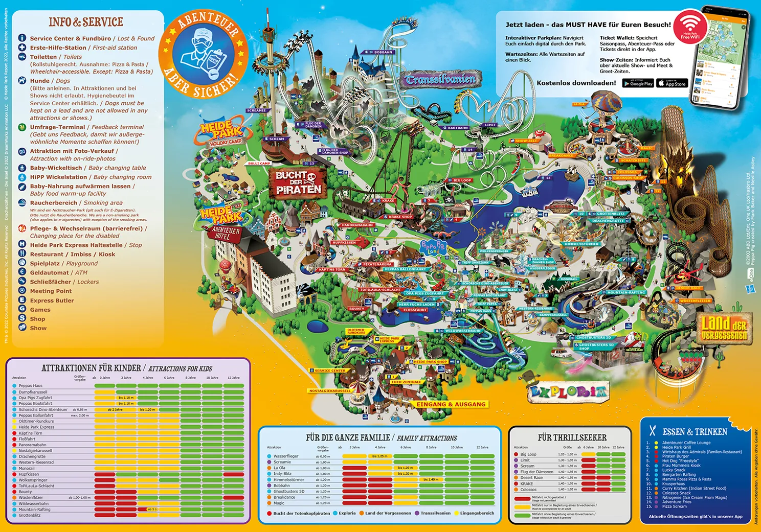
Heide-Park Soltau GmbH. (2022). Heide-Park Map. https://www.heide-park.de/media/44zpdc5i/heide_park_map_2022.jpg . Zugegriffen: [06. Apr. 2022].
Hof, A., & Schmitt, T. (2011). Urban and tourist land use patterns and water consumption: Evidence from mallorca, balearic islands. Land Use Policy, 28, (4, S. 792–804). https://doi.org/10.1016/j.landusepol.2011.01.007.
Hruby, F., Ressl, R., & de la Borbolla de Valle, G. (2019). Geovisualization with immersive virtual environments in theory and practice. International Journal of Digital Earth, 12, (2, S. 123–136). https://doi.org/10.1080/17538947.2018.1501106.
Hüttermann, A. (1998). Kartenlesen – (k)eine Kunst. Einführung in die Didaktik der Schulkartographie. Oldenbourg.
Janewicz, K., & Borowicz, D. (2017). Tourist maps – definition, types and contents. Polish Cartographical Review, 49, (1, S. 27–41).
Keil, J., Edler, D., O'Meara, D., Korte, A., & Dickmann, F. (2021). Effects of virtual reality locomotion techniques on distance estimations. ISPRS International Journal of Geo-Information, 10, (S. 3, 150). https://doi.org/10.3390/ijgi10030150.
Keil, J., Mocnik, F.-B., Edler, D., Dickmann, F., & Kuchinke, L. (2018). Reduction of map information regulates visual attention without affecting route recognition performance. ISPRS International Journal of Geo-Information, 7, (S. 12, 469). https://doi.org/10.3390/ijgi7120469.
Kersten, T. P., Deggim, S., Tschirschwitz, F., Lindstaedt, M. U., & Hinrichsen, N. (2018). Segeberg 1600 – Eine stadtrekonstruktion in virtual reality. KN – Journal of Cartography and Geographic Information, 68, (4, S. 183–191). https://doi.org/10.1007/BF03545360
Kleber, A., Edler, D., & Dickmann, F. (2020). Cartography and the sea: A javaScript-based web mapping application for managing maritime Shipping. In D. Edler, O. Kühne, & C. Jenal (Hrsg.), Modern Approaches to the Visualization of Landscapes (S. 173–186). Springer VS. https://doi.org/10.1007/978-3-658-30956-5_10.
Klippel, A., Knuf, L., Hommel, B., & Freksa, C. (2004). Perceptually induced distortions in cognitive maps. In C. Freksa, M. Knauff, B. Krieg-Brückner, B. Nebel, & T. Barkowsky (Hrsg.), Spatial Cognition IV. Reasoning, Action, Interaction (S. 204–213). Springer. https://doi.org/10.1007/978-3-540-32255-9_12.
Koegst, L. (2022). Potentials of digitally guided excursions at universities Illustrated using the example of an urban geography excursion in stuttgart. KN – Journal of Cartography and Geographic Information, 72, (1, S. 59–71). https://doi.org/10.1007/s42489-022-00097-4.
Krause, B. (2016). Wild soundscapes. Discovering the voice of the natural world. Yale University Press.
Krygier, J. B. (1994). Sound and geographic visualization. In A. M. MacEachren & D. R. F. Taylor (Hrsg.), Visualization in modern cartography (S. 149–166). Elsevier.
Kühne, O. (2023). Landschaft – eine theoretische Einordnung. In O. Kühne, T. Freytag, T. Sedelmeier, & C.Jenal (Hrsg.), Landschaft und Tourismus (RaumFragen, in diesem Band). Springer.
Kühne, O., Edler, D., & Jenal, C. (2021). A multi-Perspective view on immersive virtual environments (IVEs). ISPRS International Journal of Geo-Information, 10, (8, S. 518). https://doi.org/10.3390/ijgi10080518.
Kühne, O., Jenal, C., & Edler, D. (2020). Functions of landscape in games – A theoretical approach with case examples. Arts, 9, (4, S. 123). https://doi.org/10.3390/arts9040123.
Kühne, O., Jenal, C., & Sedelmeier, T. (Hrsg.). (2022). Cultural atlas of tÜbingenness. Kleine Karten aus dem großen TÜbiversum. Springer VS.
Laakso, M., & Sarjakoski, L. T. (2010). Sonic maps for hiking – use of sound in enhancing the map use experience. The Cartographic Journal, 47, (4, S. 300–307). https://doi.org/10.1179/000870410X12911298276237.
Lammert-Siepmann, N., Bestgen, A.-K., Edler, D., Kuchinke, L., & Dickmann, F. (2017). Audiovisual communication of object-names improves the spatial accuracy of recalled object-locations in topographic maps. PLoS ONE 12, (10, e0186065). https://doi.org/10.1371/journal.pone.0186065.
Lauriault, T.P., & Lindgaard, G. (2006). Scented Cybercartographies: Exploring Possibilities. Cartographica: The International Journal for Geographic Information and Geovisualization 41, (1, S. 74–91). https://doi.org/10.3138/W432-713U-3621-04N3.
Leser, H., Broll, G., Egner, H., Rothfuß, E., & Vetter, M. (Hrsg.). (2017). Diercke Wörterbuch Geographie (16., völlig (überarb). Westermann).
Lochhead, I., & Hedley, N. (2021). Designing virtual spaces for immersive visual analytics. KN – Journal of Cartography and Geographic Information, 71, (4, S. 223–240). https://doi.org/10.1007/s42489-021-00087-y.
MacEachren, A. M. (2004). How maps work. Representation, visualization, and design. Guilford Press.
Medyńska-Gulij, B. (2003). The effect of cartographic content on tourist map users. Cartography, 32, (2, S. 49–54). https://doi.org/10.1080/00690805.2003.9714252.
Medyńska-Gulij, B., & Zagata, K. (2020). Experts and gamers on immersion into reconstructed strongholds. ISPRS International Journal of Geo-Information, 9, (11, S. 655). https://doi.org/10.3390/ijgi9110655.
Medyńska-Gulij, B., Halik, L., Wielebski, L., & Dickmann, F. (2015). Mehrperspektivische Visualisierung von Informationen zum räumlichen Freizeitverhalten – Ein Smartphone-gestützter Ansatz zur Kartographie von Tourismusrouten. KN – Journal of Cartography and Geographic Information, 65, (6, S. 323–329). https://doi.org/10.1007/BF03545469.
Monmonier, M. (1996). How to lie with maps (2. Aufl.). University of Chicago Press.
Montello, D. R. (2002). Cognitive map-design research in the twentieth century: Theoretical and empirical approaches. Cartography and geographic information science, 29, (3, S. 283–304). https://doi.org/10.1559/152304002782008503.
Novack, T., Wang, Z., & Zipf, A. (2018). A system for generating customized pleasant pedestrian routes based on openstreet map data. Sensors, 18, (11, S. 3794).https://doi.org/10.3390/s18113794.
Padilla, L. M., Creem-Regehr, S. H., Hegarty, M., & Stefanucci, J. K. (2018). Decision making with visualizations: A cognitive framework across disciplines. Cognitive Research: Principles and Implications, 3, (29). https://doi.org/10.1186/s41235-018-0120-9.
Postma, A., & De Haan, E. H. (1996). What was where? Memory for object locations. Quarterly Journal of Experimental Psychology, 49, (1, S. 178–199). https://doi.org/10.1080/713755605.
Pustkowski, R. (1989). Anmerkungen zur touristischen Kartographie. In: Wiener Schriften zur Geographie und Kartographie (Bd. 4, S. 150–155).
Regio. (2014). Lotte Atlas. Tartu: Regio.
Schafer, R. M. (1977). The soundscape. Our sonic environment and the tuning of the world. Destiny Books.
Schito, J., & Fabrikant, S. I. (2018). Exploring maps by sounds: Using parameter mapping sonification to make digital elevation models audible. International Journal of Geographical Information Science, 32, (5, S. 874–906). https://doi.org/10.1080/13658816.2017.1420192.
Stevens, A., & Coupe, P. (1978). Distortions in judged spatial relations. Cognitive Psychology, 10, (4, S. 422–437). https://doi.org/10.1016/0010-0285(78)90006-3.
Sundriyal, S., Shridhar, V., Madhwal, S., Pandey, K., & Sharma, V. (2018). Impacts of tourism development on the physical environment of Mussoorie, a hill station in the lower Himalayan range of India. Journal of Mountain Science, 15, (S. 2276–2291). https://doi.org/10.1007/s11629-017-4786-0.
Tyner, J. (2010). Principles of map design. The Guilford Press.
Ulbert, H.-J. (1985). Die Freizeitkarte als erholungsorientiertes Kommunikations- und Informationsmittel dargestellt am Beispiel der Biggetalsperre. In: Materialien zur Fremdenverkehrsgeographie. (Bd. 13).
Vetter, M. (2020). Technical potentials for the visualization in virtual reality. In D. Edler, C. Jenal, & O. Kühne (Hrsg.), Modern approaches to the visualization of landscapes (S. 307–317). Springer VS. https://doi.org/10.1007/978-3-658-30956-5_17.
Wood, D. (1992). The Power of Maps. Guilford Publications.
Yung, R., Khoo-Lattimore, C., & Potter, L.E. (2021). Virtual reality and tourism marketing: Conceptualizing a framework on presence, emotion, and intention. Current Issues in Tourism, 24, (11, S. 1505–1525). https://doi.org/10.1080/13683500.2020.1820454.
ZOOM Erlebniswelt. (2022). Expeditionsplan. https://www.zoom-erlebniswelt.de/files/zoom/content/Ihr-Besuch/Expeditionsplan/ZOOM%20Erlebniswelt%20Expeditionsplan%202021.pdf [06.Apr. 2022].
Author information
Authors and Affiliations
Corresponding author
Editor information
Editors and Affiliations
Rights and permissions
Copyright information
© 2023 Der/die Autor(en), exklusiv lizenziert an Springer Fachmedien Wiesbaden GmbH, ein Teil von Springer Nature
About this chapter

Cite this chapter
Edler, D., Keil, J., Weißmann, M., Dickmann, F. (2023). Funktionen kartographischer Medien in touristischen Anwendungsszenarien. In: Kühne, O., Sedelmeier, T., Jenal, C., Freytag, T. (eds) Landschaft und Tourismus. RaumFragen: Stadt – Region – Landschaft. Springer VS, Wiesbaden. https://doi.org/10.1007/978-3-658-39085-3_12
Download citation
DOI: https://doi.org/10.1007/978-3-658-39085-3_12
Published:
Publisher Name: Springer VS, Wiesbaden
Print ISBN: 978-3-658-39084-6
Online ISBN: 978-3-658-39085-3
eBook Packages: Social Science and Law (German Language)