
Abstract
Vietnam’s mountainous regions often encounter landslides, frequently resulting in fatalities, infrastructure damage, and landscape destruction. A landslide susceptibility map is an effective tool for mitigating disaster impacts on hazard-prone areas. This study investigates the applicability of the Analytic Hierarchy Process to produce a landslide susceptibility index. Eight major impact factors are analyzed using SAGA, a GIS-based toolkit, including slopes, aspect, land use, soil type, elevation, distance to road, distance to stream, and antecedent rainfall. Four landslide susceptibility maps are produced corresponding to frequency scenarios of 3-day antecedent rainfall data which is taken from Regional Frequency Analysis (RFA). We assess the modeling performances using Area Under the Curve (AUC) index and the results show that the AHP model has good performance. The findings demonstrate a significant influence of rainfall antecedent conditions on the susceptibility map of landslides in this study area.
Supplementary Information
The online version contains supplementary material available at https://doi.org/10.1007/978-3-031-18471-0_7.
You have full access to this open access chapter, Download chapter PDF
Keywords
- Landslide susceptibility
- Analytic hierarchy process
- Regional frequency analysis
- Area under the Curve
- Landslide density index
1 Introduction
Landslide is one of the most regular natural catastrophes in mountainous areas. The term landslide refers to the movement of a mass of rock, debris, or earth down a slope under the influence of gravity (Cruden and Varnes 1996). In places that are impacted by landslides, it is common to have significant damage to numerous houses, as well as infrastructure and agriculture. Landslides are governed by many causative factors, namely geological, hydrological, land cover, morphological, and other factors (Reichenbach et al. 2018). Understanding the influences and mechanisms of these factors on landslides would be significant for the prevention and mitigation of damage from the landslides.
The landslide susceptibility map is considered an effective way to prepare and react in advance to avoid disasters. The map would highlight potential areas for landslides that are likely to occur in a specific area under the influences of causative factors (Brabb 1985). Many approaches have been applied for developing susceptibility maps and can be categorized into five classes (i) geomorphological mapping, (ii) analysis of landslide inventories, (iii) heuristic approaches, (iv) process-based methods, and (v) statistically based modeling methods (Khan et al. 2019).
The above methods can be grouped into quantitative and qualitative techniques. Quantitative techniques tend to develop susceptibility maps based on evaluating relationships between landslides inventory and governing factors for projecting probabilities of landslides (Guzzetti et al. 1999; Khan et al. 2019; Reichenbach et al. 2018). On the other hand, qualitative techniques estimate landslide sites according to the use of landslide inventory subjectively and traditionally (Khan et al. 2019; Guzzetti et al. 1999). On the one hand, quantitative techniques are likely to give more appropriate susceptibility zonation for high-quality monitoring data. On the other hand, qualitative techniques are more suitable for large areas but often provide low-quality data.
One of the qualitative techniques- the Analytic Hierarchy Process (AHP) method (Saaty 1987; Saaty and Vargas 1991) can be a practical approach to solve data quality problems. This approach is widely used in landslide susceptibility analysis (Pradhan and Althuwaynee, Reichenbach et al. 2018; Pourghasemi et al. 2012). The method is especially suitable to provide zonation at provincial and regional scales. AHP would rank and weigh the contribution of factors based on the expert judgments (Hansen 1984). Each causative factor have been analysed attentively for figuring out its impacts on landslide susceptibility analysis. The assessment can be called semi-quantitative (Reis et al. 2012; Van et al. 2016). It can be used efficiently to predict landslide susceptibility over large areas (Kanungo et al. 2012).
The results of a landslide susceptibility zonation strongly relies on landslide monitoring data; however, the quality of monitoring data in Vietnam is poor and limited to access (Chuang and Shiu 2018). In addition, data collection from many regions in Vietnam is mainly based on reports from local people and local committees. However, these reports may contain some spatial and temporal misleading for mapping and identifying landslide mechanisms (Hung 2011). Some datasets are provided by different authorities, such as transportation sectors and flood and storm committees, leading to many complications in collecting data for research projects.
Selecting appropriate rainfall data for landslide analysis is one of the concerning problems. Many pieces of landslides susceptibility research have been carried out using annual rainfall data instead of antecedent rainfall (Hung 2011). Meanwhile, antecedent rainfall is a significant trigger corresponding to most landslide incidents in the region (Naidu et al. 2018; Pradhan et al. 2017). In this research region, most of the landslides are strongly correlated to 3-days antecedent rainfall caused by tropical storms and monsoon (Phuoc et al. 2019). Therefore, the analysis of the landslide susceptibility index based on yearly rainfall is still questionable, affecting the accuracy of the maps. This gap can be covered by selecting appropriate antecedent rainfall periods of data for estimating the susceptibility index of landslides.
The projection of the susceptibility index offers a scientific foundation for predicting the occurrence of landslides. Nevertheless, these pieces of research are still limited in the study area. As mentioned before, research on landslides often relies on yearly rainfall and may fail to include the frequency terms (Pradhan et al. 2017; Phuoc et al. 2019). Additionally, the quality of the findings might be significantly impacted by short and insufficient monitoring periods and low-density monitoring stations of precipitation data (Naidu et al. 2018). To enhance the predictability of landslide susceptibility, the Regional Frequency Analysis (RFA), which is used to calculate rainfall frequency, is added into the modeling of landslide susceptibility (Hosking and Wallis 1997, 2005; Phuoc et al. 2019).
The RFA algorithm provides likelihood spatial distribution maps of different antecedent periods and various frequencies of rainfall (Nguyen and Nguyen 2017). These maps are useful for investigating terrain instability based on GIS analysis (Pradhan and Althuwaynee, Pradhan et al. 2017, Hansen 1984). The application of this method can overcome the limitation of current spatial and temporal data which can make important contributions to increasing the certainty of landslide susceptibility calculating.
Therefore, this research aims to investigate the impact of rainfall frequencies on landslide susceptibilities using RFA and AHP methods. The RFA approach evaluates and provides the spatial distribution of antecedent rainfall in various frequencies. A GIS-based AHP analysis would be practical to generate landslide susceptibility zoning in large areas. The landslide susceptibility map, represented according to rainfall return periods, would be critical for preventing and mitigating landslide hazards in the research region.
2 Case Study
The study focuses on evaluating landslide susceptibility for three mountainous districts of the Quang Ngai province (Fig. 1). This study area covers an area of 1.352 km2. The highest altitude of the study area is 1694 m and is in the west, near the Central Highland provinces and the Truong Son Mountain range. Quang Ngai Province’s lowland area is east of the study area.

Location of the study area and the landslide inventory map
This region is very susceptible to landslides and has lately had several occurrences. Landslides often occur in this region between September and December, which is also a time of heavy rainfall (more than 70% of the region’s annual 2500 mm rainfall is accounted for by rainfall from tropical storms and tropical monsoons). According to reports from local natural disaster management authorities, extreme antecedent rainfall is the principal trigger of landslides in the region.
The natural condition of the mountainous area has increasing the risk of landslides. Firstly, the steep slope terrain is a major cause for the instability of shallow landslides. A considerable proportion of natural forests are replaced by forest plantations, agriculture, or bush which enhances the erosion and instability of land, leading to soil mass movement on the shallow surface. Another problem is the high density of streams together with high antecedent rainfalls making it a significant contribution to the high risk of landslides in the region. Finally, rapid investment in road infrastructure, resulting in changing terrain in road buffering, increases slope instability along these roads.
3 Materials and Methods
A GIS-based multi-criterion analysis is used for developing landslide susceptibility maps. Seven landslide causative factors, including slopes, aspects, elevation, soil types, land use, distance to road, and distance to stream, were used to spatially investigate the landslide susceptibility of the region (Khan et al. 2019; Reichenbach et al. 2018; Pourghasemi et al. 2012). The method also utilized the advantages of spatial analysis to highlight the probability of landslides based on an analysis of geographical, topographical, and meteorological data and landslide events (Khan et al. 2019; Chuang and Shiu 2018). To ensure the projection of susceptibility, high-quality geographical distribution data of influencing factors are collected and analyzed (Hansen et al. 1995; Feizizadeh et al. 2014; Pham et al. 2017). The whole procedure is carried out on QGIS 3.12. and on the SAGA toolkit. Maps are also generated by using QGIS 3.12.
A database of 339 landslides that occurred between 2010 and 2018 was used in this study to construct the susceptibility assessment and validation. The database was compiled using data from landslide inventories based on Landsat satellite images and yearly reports from the flood and storm committee. The landslide locations were then split into two groups using spatial randomization, with 237 locations as a training dataset and the remaining 102 locations as a testing dataset.
To develop landslide susceptibility and lessen uncertainty in the outcomes, we prepare and collect high-resolution geographical and temporal data on the causative factors. In addition, rainfall data was taken from RFA for 3-day antecedent rainfall following two common frequencies of P50% and P20% and two extreme frequencies of 2% and 1% instead of using annual rainfall data. The diagram of the entire process is represented in Fig. 2.

Diagram of landslide susceptibility project using AHP and RFA methods corresponding to four frequencies scenarios of rainfall
An AHP processing pair-wise comparison matrix is suggested after consulting with experts and literature reviewing. Contribution weights of environment factors (slopes, aspects, elevation, land used, soil types, and distance to rivers) and human activities factors (distance to roads) are analyzed according to the training dataset. These causative elements, coupled with four maps of 3-day antecedent rainfall according to four frequencies (P50, P25, P2, P1%), are utilized to construct landslide susceptibility indices after reclassifying geographical distribution following contribution weights. These maps are utilized for generating a landslide susceptibility map with five classifications (very high, high, medium, low, and very low) using the Natural Break classifier. These susceptibility thresholds were then manipulated to build the landslide susceptibility maps for the research area corresponding to each rainfall frequency. The quality of projection results is validated using Area Under the Curve (AUC) index and Landslide Density (LD) using the testing dataset.
3.1 Landslide Causative Factors
This research produces a landslide susceptibility index based on the relative importance of eight influencing factors: rainfall, slope, elevation, aspect, distance to streams, distance to roads, land use, and soil type.
-
Rainfall: Phuoc et al. (2019) indicated that 3-day antecedent rainfall is the most significant trigger of landslides. The inventory also highlights that landslides happened in the region annually and more incidents were recorded corresponding to extreme rainfall events. Thus, we examine the impacts of precipitation triggers for two groups of 3-day antecedent scenarios: (i) regular rainfall scenarios correspond to frequency p = 50% (P50) and 25% (P25); (ii) extreme rainfall scenario group with frequency p = 2% (P2) and 1% (P1). Maps of the distribution of rainfall are produced for each rainfall scenario. These maps represent better temporal and spatial resolution than other interpolation methods (Nguyen and Nguyen 2017). This research used RFA-based rainfall data observed for many years from 75 rain gauge stations for the interpolation. The spatial distribution of 3-day antecedent rainfall for the research area is shown in Fig. 3.
Fig. 3 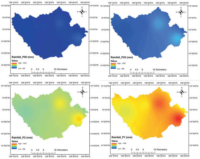
Spatial distribution of 3-day antecedent rainfall corresponding to four frequencies P50%, P25%, P2%, and P1%
-
Terrain slope: Terrain slope is the most significant variation in landslide causatives. The review from Reichenbach et al. (2018), and Naidu et al. (2018) have accentuated the critical role of the factors in the instabilities of the interested area. The terrain slope in the research area was prepared from the SRTM DEM (30 × 30 m) using the QGIS 3.12. The obtained results are subsequently classified into different classes based on correlation with landslide occurrence and ranging from 10 to 70° with 10° steps.
-
Terrain aspect: The terrain aspect has a strong interrelationship with land cover, soil strength, and moisture, which directly influence landslide initiation (Khan et al. 2019). Therefore, assessing the influences of terrain directions on landslides would contribute to the projection of landslide susceptibility. The aspect layer for the research is also generated from the collected DEM.
-
Soil type: Due to differences in shear strength and hydraulic conductivity, soil types respond differently to rainfall (Chuang and Shiu 2018). Consequently, reaching a saturated situation, which is an important trigger to landslides, is more likely to be a unique value associated with each soil type. Integrating the relationship between spatial distribution of soil types and occurred incidents would enhance certainty for landslide susceptibility assessment. Spatial distribution soil types data in the research area is provided by local management agencies and processes in ESRI ArcGIS.

-
Land-cover: According to Khan et al. (2019), land cover is the main influential parameter of slope stability. A good vegetation cover would work effectively in retaining water, reducing erosion, and improving the stability in the area (Reichenbach et al. 2018). The research has used a land-use map in the year 2010 for slope instability investigation for the province.
-
Distance to roads: In mountainous areas, the development of transportation may lead to a reduction in the stability of the slope and eventually landslides. Therefore, distances from the road become a significant trigger to landslide occurrences. In the research, a database of the transportation system is collected from local authorities and processed to use in landslide susceptibility analysis.
-
Distance to stream: Many studies have commonly used the factor—distances to streams—to analyze landslides susceptibility (Khan et al. 2019). The contribution of spatial distributions of the rivers and springs in landslides is evaluated in a GIS environment using data from authorities.
-
Elevation: is the height of the terrain surface that affects landslide occurrences (Varnes 1984). Rocks appearing at higher elevations are less weathered due to geo-environmental factors. Therefore, landslides often have less frequency in very high elevation areas (Pham et al. 2019). In this study area, the inventory data shows that the most susceptible to landslide incidence is with in elevation range of 720–900 m.
3.2 Analytic Hierarchy Process Method
The AHP method has been used widely to develop an appropriate landslides susceptibility map. A pair-wise comparison matrix provides an estimation of landslide causative factors’ contribution. A range with numerical values from 1 to 9 was recommended for comparing criteria by Saaty (1987). Each of these numbers shows the degree of importance in a way that 1 shows equal importance and 9 show the extremely strong importance of a criterion compared to another quantitative criterion (Saaty 1987).
The greatest weight in the AHP method represents a layer having the most significant impact on determinations of the objective. In other words, the criteria for weighing each information unit are also based on the greatest effect played by that factor in the layer. A range with numerical values ranging from 1 to 9 was proposed to compare the criteria. In addition, Consistency Ratio (CR) and Consistency Index (CI) would be calculated to estimate the consistency of the AHP process (Saaty 1987). Note that the CR value must be less than 0.1. If not, the pair-wise table is considered inconsistent (Saaty 1987).
where: λmax represents the largest Eigenvector of the matrix and n represents the total causative factors (order of the matrix) used in the projection. CR (Consistency Ratio) and CI (Consistency Index), RI (random index) is the average value of CI for a randomly generated pairwise matrix.
To estimate the contribution and correlation of each causative factors to the phenomena, a frequency analysis was established for landslide events. 102 landslides were used to figure out the relationship between landslides and rainfall characteristics in the research area. Another 237 landslides were utilized in spatial analysis, and 102 landslides were used to validate the result.
3.3 Regional Frequency Analysis Method
The regional frequency analysis method was first proposed by Hosking and Wallis in 1997. The method can be used with any kind of data (Hosking and Wallis 1997). In this work, it is regional rainfall. In the regional rainfall frequency method, the index rainfall is computed as the average of the local series (Hosking and Wallis 1997), based on an L-moment procedure (Ngongondo et al. 2011). However, in this study, we used a likelihood of observed sample-based Bayesian Markov chain Monte Carlo (MCMC) procedure as suggested by Gaume et al. (2010). Because it uses the full likelihood function, which is aneffective and flexible way to represent information for a site, whether it is count, interval, or magnitude.
Following Dalrymple (1960), the quantile of non-exceedance probability F at site i may be written:
where x(F) is the regional quantile of non-exceedance probability F, the index rainfall µi is the average value of the sample for site i.
A Bayesian MCMC procedure is now relatively common for hydrological applications (Gaume et al. 2010; Nguyen et al. 2014). Following the Bayes’ theorem, the likelihood of the sample given the parameters of the statistical model \({\text{L}}(D|\theta )\) can be related to the likelihood or density of probability of the parameters given the sample \({\text{p}}(\uptheta |D)\).
where p(θ) is the prior distribution of θ, p(D) is the probability of sample D, which is unknown.
The inference approach applied herein is directly derived from Gaume et al. (2010). It is based on the likelihood of the available data sets and a Bayesian MCMC algorithm for estimating the growth curve parameters and their posterior distribution according to the observed data set. The likelihood of the observed sample (D) is calculated as follows:
where fθ is the probability density function of the selected statistical distribution for the regional growth curve, and θ corresponds to the vector of parameters of the distribution selection to be estimated.
The study will only briefly present this procedure. The details of the algorithm are included in the R software library nsRFA. This method has been applied to the Central and Central Highlands regions of Vietnam (Nguyen and Nguyen 2017).
4 Result and Discussion
4.1 Analytic Hierarchy Process
Based on the contribution from experts and literature reviews, a pair-wise comparison matrix has been introduced for AHP for landslide susceptibility maps production (See Table 1). With CI = 0.1005 and CR = 0.072 < 01, the matrix is adequate for further analysis.
The analysis of the recorded landslides shows a strong correlation between distance from stream and distance from roads to landslide zonation. While spatial distribution of landslides is strongly correlated to the distance to transportation systems and stream system, the highest proportion of landslide events falls into the closest area to the stream with a 200 m buffer distance. It is also marked that the influence of road on the phenomena is more likely limited in areas lower than 600 m buffer zone, while the impacts of distance from stream tend to continue and reduce steadily until over the distance of 1000 m.
Investigating the impact of soil types also highlights that those landslides are more likely to happen in areas with Epi Lithi Ferralic Acrisols as the most instability soil and Epi Lithi Humic Acrisols as the second. So, these soil types are respectively assigned with points of 9 and 7 in contribution factors. From 2010 to 2018, forest production and bust accounted for the highest landslide frequencies in terms of land cover (Table 2).
4.2 Landslides Susceptibility
Implementation GIS-based AHP analysis with RFA rainfall data and other seven causative factors on SAGA toolkit generated four landslides susceptibility maps. These maps are then used to calculate a mean of landslide susceptibility map as a basis for classifying based on Landslide Susceptibility Indexes (LSIs) following the natural break approach. There are five levels of susceptibility for this phenomenon represented in Table 3 and Fig. 4: very low, low, medium, high, and extremely high. Spatial distributions of landslide susceptibility find a strong correlation with slopes map, which is the most contributing factor. Most of the high and very high risk of landslides fall into 40–50° terrain slopes. However, spatial distributions of slides also indicate the contribution of other factors to landslide susceptibility. Figure 4 represents the statistical index of the mean of landslide susceptibility. Susceptibility is in a range from 1.7 to 7.7. Whereas the value in the range of 10% percentile and 90% percentile are 3.3 and 6.2, respectively. The deviation of the result represents the consistency of the projection, with the mean value being 4.2 and the standard deviation being 0.87.

Map of mean of landslide susceptibility based on 3-day antecedent rainfall
Figures 5 and 6 highlight the impacts of rainfall on the landslide susceptibility index in the area. Four landslide susceptibility maps were produced using AHP according to different 3-day antecedent rainfall frequencies—50, 25 2, and 1%. There is a significant increase of landslides in high-risk areas according to the increasing rainfall frequencies. The proportion of high and very high increases doubled compared from P25 to P2%. There was a significant increase in very high landslide susceptibility following the rising of rainfall frequencies from P50% to P1%. In contrast, the proportion of low susceptibility areas reduced from 25% in P50% to over 5.2% in P1%. The figure for medium susceptibility is more likely to remain the same in comparison to these frequencies, which account for a quarter of the research area.

Landside susceptibility maps for 4 rainfall frequencies scenarios a P50%, b P25%, c P2%, d P1%

Area percentage of five landslide susceptibility levels for 4 rainfall frequencies scenarios
Landslide susceptibility shown in Fig. 5 would be useful for natural disaster prevention sectors in the development plan in this research region. Undoubtedly, it would highlight locations at considerable risk of landslide based on real-time precipitation and then make decisions for evacuation and prevention. Consequently, the damage to properties, infrastructure, and human life in the area is reduced.
Figure 7 indicates the agreement on project landslide susceptibility following the AHP process for this study area and recorded events. The obtained results represent that most landslide susceptibility falls into high and very high categories. In the maps of P50%, the proportion of high and very high classes is just over 20% while accounting for 80% of landslide density. The significant figure is very high with only 4% of the area but accounts for 48% of landslide density. Some landslides fall into low and very low classes. However, the proportion of these two levels is very low, with under 10% of a recorded landslide. The increase in landslide density is marked at the highest level. On the other hand, the percentage of landslides in the lower class has decreased following frequencies.

Landslide density for five landslide susceptibility levels for 4 rainfall frequencies
The AUC assessment has been highlighted appropriately of the AHP method in producing landslides susceptibility maps (see Fig. 8). The AUC index based on training landslide sites is slightly higher than the testing data. The AUC indexes of different rainfall return periods models are around 0.75. This assessment indicates that the application of AHP is suitable for landslide susceptibility predition in this region. So, applied parameters for this study can be utilise for other tropical monsoon climate areas where rainfall is the most significant trigger of landslides. The obtained results can also propose a fundamental reference for further studies that should approach more modern methods in landslide susceptibilities such as machine learning and deep learning to improve computing efficiency.

a The success rate curves and b prediction rate curves corresponding to 4 rainfall frequencies scenarios
5 Conclusion
The research has represented a method to generate a landslides susceptibility map by application of the Analytic Hierarchy Process to produce an index for landslide projections. Eight major impact factors are analyzed to highlight the importance of causative factors. The slope is the highest contributing factor to landslides with a weight of 0.318, while land use is the second-highest factor. The smallest contribution weight to landslide susceptibility in the area is elevation, which accounts for only 0.018. With CI = 0.1005 and CR = 0.072 < 01, the matrix is adequate for further analysis in regional scale or event place have similar conditions.
Result also highlights the importance of selecting rainfall in landslide susceptibility prediction. Landslide susceptibility maps that result from different scenarios can be used to produce landslides warning according to rainfall forecasting. Application of Regional Frequency Analysis (RFA)s in the analysis provide an alternative approach for investigation the influence of rainfall on zonation of landslides susceptibility in the area where precipitation is the most dominatant trigger for landslide events.
References
Brabb EE (1985) Innovative approaches to landslide hazard and risk mapping. In: International landslide symposium proceedings, Toronto, Canada, pp 17–22
Chuang YC, Shiu YS (2018) Relationship between landslides and mountain development-Integrating geospatial statistics and a new long-term database. Sci Total Environ 622–623:1265–1276
Cruden DM, Varnes DJ (1996) Landslides: investigation and mitigation. Chapter 3-Landslide types and processes. Transportation research board special report
Dalrymple T (1960) Flood frequency analyses, volume 1543-A of Water Supply Paper. US Geological Survey, Reston, Va
Feizizadeh B, Roodposhti MS, Jankowski P, Blaschke T (2014) A GIS-based extended fuzzy multi-criteria evaluation for landslide susceptibility mapping. Comput Geosci 73:208–221
Gaume E, Gaál L, Viglione A, Szolgay J, Kohnová S, Blöschl G (2010) Bayesian MCMC approach to regional flood frequency analyses involving extraordinary flood events at ungauged sites. J Hydrol 394:101–117
Guzzetti F, Carrara A, Cardinali M, Reichenbach P (1999) Landslide hazard evaluation: a review of current techniques and their application in a multi-scale study, Central Italy. Geomorphology 31:181–216
Hansen A, Franks C, Kirk P, Brimicombe A, Tung F (1995) Application of GIS to hazard assessment, with particular reference to landslides in Hong Kong. Geographical Information Systems in Assessing Natural Hazards. Springer
Hansen MJ (1984) Strategies for classification of landslides. Slope Instability 1–25
Hosking J, Wallis J (1997) Regional frequencys analysis.[sl]. Cambridge University Press
Hosking JRM, Wallis JR (2005) Regional frequency analysis: an approach based on L-moments. Cambridge University Press
Hung PV (2011) Review of current status and landslide hazard zonation for the Quang Nam province. Vietnam J Earth Sci 33
Kanungo D, Arora M, Sarkar S, Gupta R (2012) Landslide susceptibility zonation (LSZ) mapping–a review
Khan H, Shafique M, Khan MA, Bacha MA, Shah SU, Calligaris C (2019) Landslide susceptibility assessment using frequency ratio, a case study of northern Pakistan. Egypt J Remote Sens Space Sci 22:11–24
Naidu S, Sajinkumar K, Oommen T, Anuja V, Samuel RA, Muraleedharan C (2018) Early warning system for shallow landslides using rainfall threshold and slope stability analysis. Geosci Front 9:1871–1882
Ngongondo CS, Xu C-Y, Tallaksen LM, Alemaw B, Chirwa T (2011) Regional frequency analysis of rainfall extremes in Southern Malawi using the index rainfall and L-moments approaches. Stoch Env Res Risk Assess 25:939–955
Nguyen CC, Gaume E, Payrastre O (2014) Regional flood frequency analyses involving extraordinary flood events at ungauged sites: further developments and validations. J Hydrol 508:385–396
Pham BT, Prakash I, Chen W, Ly H-B, Ho LS, Omidvar E, Tran VP, Bui DT (2019) A novel intelligence approach of a sequential minimal optimization-based support vector machine for landslide susceptibility mapping. Sustainability 11:6323
Pham BT, Tien Bui D, Prakash I, Dholakia MB (2017) Hybrid integration of Multilayer Perceptron Neural Networks and machine learning ensembles for landslide susceptibility assessment at Himalayan area (India) using GIS. Catena 149:52–63
Phuoc VND, Binh NQ, Hung PD, Long DV, Cong NC (2019) Studies on the causes of landslides for mountainous regions in central region of Vietnam. J Sci Technol Univ Danang 17:5
Pourghasemi HR, Pradhan B, Gokceoglu C (2012) Application of fuzzy logic and analytical hierarchy process (AHP) to landslide susceptibility mapping at Haraz watershed Iran. Nat Hazards 63:965–996
Pradhan AMS, Kang H-S, Lee J-S, Kim Y-T (2017) An ensemble landslide hazard model incorporating rainfall threshold for Mt. Umyeon, South Korea. Bull Eng Geol Env 78:131–146
Pradhan B, Althuwaynee O, Ensemble of data-driven EBF model with knowledge based AHP model for slope failure assessment in GIS using cluster pattern
Reichenbach P, Rossi M, Malamud BD, Mihir M, Guzzetti F (2018) A review of statistically-based landslide susceptibility models. Earth Sci Rev 180:60–91
Reis S, Yalcin A, Atasoy M, Nisanci R, Bayrak T, Erduran M, Sancar C, Ekercin S (2012) Remote sensing and GIS-based landslide susceptibility mapping using frequency ratio and analytical hierarchy methods in Rize province (NE Turkey). Environ Earth Sci 66:2063–2073
Saaty RW (1987) The analytic hierarchy process—what it is and how it is used. Math Model 9:161–176
Saaty TL, Vargas LG (1991) Prediction, projection, and forecasting: applications of the analytic hierarchy process in economics, finance, politics, games, and sports, Kluwer Academic Pub
Van NTH, van Son P, Khanh NH, Binh LT (2016) Landslide susceptibility mapping by combining the analytical hierarchy process and weighted linear combination methods: a case study in the upper Lo River catchment (Vietnam). Landslides 13:1285–1301
Varnes DJ (1984) Landslide hazard zonation: a review of principles and practice
Acknowledgements
Doan Viet Long was funded by Vingroup Joint Stock Company and supported by the Domestic Master/Ph.D. Scholarship Programme of Vingroup Innovation Foundation (VINIF), Vingroup Big Data Institute (VINBIGDATA), VINIF.2021.TS.122.
The study is partly funded by Project NVTX. 2022.03.09 and TNMT.2019.03.01
Author information
Authors and Affiliations
Corresponding author
Editor information
Editors and Affiliations
Rights and permissions
Open Access This chapter is licensed under the terms of the Creative Commons Attribution 4.0 International License (http://creativecommons.org/licenses/by/4.0/), which permits use, sharing, adaptation, distribution and reproduction in any medium or format, as long as you give appropriate credit to the original author(s) and the source, provide a link to the Creative Commons license and indicate if changes were made.
The images or other third party material in this chapter are included in the chapter's Creative Commons license, unless indicated otherwise in a credit line to the material. If material is not included in the chapter's Creative Commons license and your intended use is not permitted by statutory regulation or exceeds the permitted use, you will need to obtain permission directly from the copyright holder.
Copyright information
© 2023 The Author(s)
About this chapter

Cite this chapter
Nguyen, C.C., Vo, P., Doan, V.L., Nguyen, Q.B., Nguyen, T.C., Nguyen, Q.D. (2023). Assessment of the Effects of Rainfall Frequency on Landslide Susceptibility Mapping Using AHP Method: A Case Study for a Mountainous Region in Central Vietnam. In: Alcántara-Ayala, I., et al. Progress in Landslide Research and Technology, Volume 1 Issue 2, 2022. Progress in Landslide Research and Technology. Springer, Cham. https://doi.org/10.1007/978-3-031-18471-0_7
Download citation
DOI: https://doi.org/10.1007/978-3-031-18471-0_7
Published:
Publisher Name: Springer, Cham
Print ISBN: 978-3-031-18470-3
Online ISBN: 978-3-031-18471-0
eBook Packages: Earth and Environmental ScienceEarth and Environmental Science (R0)