
Abstract
In 2014 the Island of El Hierro (Canary Islands) was declared a Geopark of the Unesco network, thus becoming the first UNESCO geopark of the Canary Islands. The geological history of the Island of El Hierro can be understood through the visit of 61 geosites, which are representative of the growth and destruction of an oceanic Island in an intraplate environment. The geological heritage represented by these geosites has as foremost exponents those related to the formation of mega-landslides and the formation of extensive fields of pahoehoe lava-flows related to the historical or prehistoric fissure volcanism concerning the activity of its three rifts. This chapter describes the methodology used in establishing the geosite inventory carried out in 2019, as well as the description of the established geosites.
You have full access to this open access chapter, Download chapter PDF
Keywords
1 Introduction
To proceed with the conservation and sustainable use of the geological heritage of any space, it is necessary to carry out the inventory of geosites (Carcavilla et al. 2009; García-Cortés et al. 2014; Brilha 2016). The Island Council of El Hierro presented the candidacy to be part of the “European Geoparks Network” (EGN) and “The Global Geoparks Network” (GGN) on October 1, 2012. In September 2014, the island of El Hierro it joins the EGN and GGN under the auspices of UNESCO, definitively declaring itself El Hierro Geopark. In November 2015, during the 38th General Conference of UNESCO, the approval of the “International Program of Earth Sciences and Geoparks (PIGG)” was ratified, thus entering El Hierro Geopark to form part of the World Geoparks Network of UNESCO, now renamed the UNESCO World Geopark.
The Geopark project Dossier contained a list and description of the Geosites and Geozones, which included a total of 7 Terrestrial Geozones, 3 Marine Geozones, 28 Terrestrial Geosites and 15 Marine Geosites.
Among the LIGs selected on that occasion was The Golfo Valley. The Golfo Valley is included in the Global Geosite VC010 “The El Golfo landslide (El Hierro)”. It is a part of the Global Geosites inventory for Spain (Garcia-Cortés et al. 2008), a global inventory of the Earth’s geological heritage (IUGS project had the support of ProGEO, IUCN and UNESCO). It is representative of the “Volcanic morphologies and edifices from the Canary Islands” nº 14 geological framework for Spain (Barrera 2009).
The review of the inventory of geosites of El Hierro Geopark, shown in this chapter, is a consequence of the need to face a precise identification, description and interpretation of the component elements of the island’s geological heritage. These are understood as the whole of natural resources originated by geological processes and with scientific, cultural and/or educational value, such as the geological formations and structures, landforms, minerals, rocks, fossils, soils and other geological manifestations. They allow us to know, study and interpret the origin and evolution of the island of El Hierro, the processes that have shaped it, and the climates and landscapes of the past and present.
Thus, the present study starts from a double objective. The first one sicks to reflect the representativeness and the totality of the geodiversity of the island of El Hierro, which is barely formally characterized. The second is to identify the land and marine geosites of El Hierro Geopark.
To carry out this inventory of geosites of the El Hierro Geopark, there is a protocol already established worldwide that starts from the collection of information from the opinions of a panel of experts so that the points are selected according to their scientific values, educational, informative, tourist attraction, etc.
Therefore, this chapter will address the following aspects related to the recent Inventory of geosites of the El Hierro Geopark:
-
The description of the methodology used in the establishment of geosites.
-
The denomination of terrestrial land and marine geosites in El Hierro Geopark.
-
The description of the proposal sheets for a geosite.
-
The classification of the different geosites.
2 Methodology
To carry out the preliminary selection of geosites, the methodology proposed by the Spanish Geological Survey (IGME) (García-Cortés et al. 2000, 2014) has been followed.
2.1 Bibliographic and Documentary Compilation
The first task faced by the work team, made up of professors from the Departmental Unit of Geology of the Department of Animal Biology, Edaphology and Geology of La Laguna University, was the bibliographic and documentary compilation on the Geology of El Hierro. The information to be collected focused on four fundamental themes:
-
Information available on the geological characteristics (with a multi-disciplinary nature) of the Island of El Hierro, and its geodynamic evolution. This information has included the MAGNA geological cartography and has served to become aware of the geosites that should be represented in the inventory and select the team of scientific collaborators who have been invited to participate in the selection of these geosites.
-
Information on protected natural spaces and other elements of interest, both natural and historical and/or cultural heritage, as well as the legal regulations relating to of them. Its interest lies in knowing, on the one hand, what the level of protection of the elements to be inventoried can be and, on the other, what non-geological values can reinforce or complement the interest of the inventoried elements.
-
Possible pre-existing geosite inventory initiatives in El Hierro Geopark. The work carried out rigorously in this field has been taken advantage of (such as the previous geosite inventory carried out in 2014, or the geosites collected in the reports of the geological sheets at 1:25,000 scale of La Restinga, Sabinosa, Valverde and Frontera).
-
Guidebooks for scientific excursions and congresses carried out on the Island of El Hierro, such as the Geo-guides published by the Geological Society of Spain, as well as other guides on nature or protected natural areas that have sufficient scientific rigour.
2.2 Constitution of the Working Group and Election of Collaborating Experts
Given the complexity and variety of the geological record of the El Hierro UGG, both in time and space, it is easy to understand the need for expert collaborators in the different branches of Geology. Those support the inventory work team when selecting the most representative places for each of the themes involved in the geological diversity of the Island of El Hierro (Volcanology, Petrology-Geochemistry, Geomorphology, Sedimentology, Tectonics, Hydrogeology, Paleontology and Edaphology). Therefore, it is necessary to have experts who cover all these disciplines. The coordinating team selected these expert collaborators after analyzing the bibliography referring to the geology of El Hierro and invited them to participate in the inventory project.
2.3 Selection of the Geosites of the El Hierro UGG
To carry out a preliminary selection of all those places that, in the opinion of the work team and the expert collaborators, had the possibility of being incorporated into the inventory, we proceeded, in a similar way to that proposed by the Delphi methodology, described by García-Cortés et al. (2014), through several rounds of surveys carried out by all the experts.
Through these surveys, the experts were informed that they would carry out their geosites proposal taking into account the intrinsic values, those linked to their potential for use (scientific, educational or touristic) and those linked to their need for protection, following the proposal of Cendrero (1996), such as scientific knowledge, representativeness, rarity, type or locality of reference, state of conservation, protection status and legislation, conditions for the observation, geological diversity, scenery, scientific-didactic-touristic content and use, and presence of other natural or cultural assets.
3 Inventory of Geosites in the El Hierro UGG
Table 1 shows the geosites proposed for the El Hierro UGG in this report, classified according to the geological contexts defined on the Island of El Hierro by the coordinating team (shield vulcanism, rift vulcanism, central volcanic complexes; prehistoric and historical vulcanism; alluvial and fluvial-torrential processes and deposits; gravitational processes and deposits; coastal processes and deposits; geological elements submerged below sea level; volcanic or sedimentary aquifers; paleontological sites; tectonic structures; soils). This table also shows the main geological interests for each geosite. The location of these geosites appears in Fig. 1.

Location and distribution of the selected Geosites in the El Hierro UGG (the points and areas with a red transparent grid)
The table shows the geosites grouped into:
-
(A)
The 18 geosites representing the 33% with the highest score in the opinion of the experts consulted (shown in blue in Fig. 1).
-
(B)
The 29 geosites that obtained a score higher than 5, in the opinion of the experts consulted (shown in yellow in Fig. 1).
-
(C)
The two remaining geosites are those that the coordinating team, in light of the regional knowledge of the geology of the Island of El Hierro, included in the best-valued 33%. However, they would not have deserved the recognition of the experts consulted (shown in black in Fig. 1).
Nevertheless, althogh the experts consulted only proposed a submarine geosite (EH-012. Tagoro Submarine Volcano), the coordinating team considered it necessary to include the submarine geosites that were already catalogued as geosites in the El Hierro Geopark in 2014 (shown in blue in Fig. 1): EH-048. El Salto; EH-049. El Diablo Cave; EH-050. El Bajón; EH-051. Baja Bocarones; EH-052. El Arco; EH-053. La Hoya; EH-054. Baja de la Palometa; EH-055. Charco Manso; EH-056. La Caleta; EH-057. Bajón del Puerto; EH-058. Roque de la Bonanza; EH-059. Baja de Anacón; EH-060. Los Negros and EH-061. El Barbudo.
After establishing the geosites of the Geopark and following the Methodology proposed by the IGME (García-Cortés et al. 2000, 2014), the team coordinating this review prepared the files for the Inventory of Geosites of El Hierro UGG. A descriptive sheet has been made for each geosite (Table 2). This descriptive sheet includes the following aspects.
-
(A)
The denomination of the geosite. In this case, two letters and three figures are used for the code (EH, El Hierro; 01, 2-digit code) and a name that describes the geological element and its geographical location (example: San Andrés fault in Barranco de Tiñor).
-
(B)
Short description. The description of the rocky outcrop of interest is introduced in this section, providing the essential geosite data (lithology, structure, age, etc.).
-
(C)
Justification of interest. In this section, it is necessary to indicate the interest rate of its content from the geologycal point of view: volcanological, petrological, tectonic, etc. In addition, evaluative comments are also introduced about the importance of the geosite concerning the interpretation of the geological history of the El Hierro, the exclusivity of the geosite and its relationship with other aspects of the heritage (historical, archaeological, ethnographic, etc.), as well as its valuation from the informative, didactic or recreational point of view.
-
(D)
Justifying parameters of the choice of the place. This section refers to the evaluation parameters that we indicate in Sect. 2.3: the intrinsic values, the values linked to their potential for use (scientific, educational or touristic) and the values linked to their need for protection. Each geosite was assigned specific valuation parameters.
-
(E)
Location. The province, the municipality and the toponymic name of the place where the geosite is located are indicated. The UTM coordinates of the center of the area encompassed by the geosite are also determined.
-
(F)
Description of the access route. This section describes the path or route to be followed to visit the geosite. The names of the arrival roads or the approaching paths are identified, etc.
-
(G)
Situation diagram with delimitation proposal. A map or an aerial or satellite photo with the delimitation of the geosite is also added for a better location.
-
(H)
Photograph (s) of the place. In this section, the photographs were deemed appropriate for better identification and description of the geosite.
-
(I)
Bibliographic references. This section lists the books, geological maps, scientific articles, etc., which describe the characteristics of the geosite.
-
(J)
Author of the proposal. This last chapter indicates the members of the panel of experts who have proposed this outcrop as a geosite in the survey launch phase, described in Sect. 2.3 of this work (Table 2).
Fig. 2 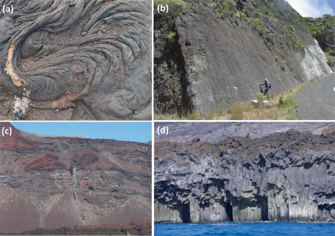
Examples of some geosites from the El Hierro UGG inventory: pahoehoe lavas from the EH-002 El Lajial geosite (a); San Andrés fault slickenside from the EH-006 The San Andrés fault (in the Barranco de Tiñor) geosite (b); the pyroclastic cones dissected by the cliff from the EH-021 The pyroclastic cones dissected from the cliffs (La Punta de los Reyes) geosite (c); and spectacular coastal caves with columnar joints from EH-040 Coastal columnar joints in the Cachopo área (d)

References
Barrera JL (2009) Volcanic edificies and morphologies of the Canary Islands. In: García-Cortés A, Águeda Villar J, Palacio Suárez-Valgrande J, Salvador González CI (eds) Spanish geological frameworks and geosites. An approach to Spanish geological heritage of international relevance. Publicaciones del Instituto Geológico y Minero de España (IGME), Madrid, pp 146–156
Brilha JB (2016) Inventory and quantitative assessment of geosites and geodiversity sites: a review. Geoheritage 8:119–134
Carcavilla L, Durán JJ, García-Cortés A, López-Martínez J (2009) Geological heritage and geoconservation in Spain: past, present, and future. Geoheritage 1:75–91
Cendrero A (1996) El patrimonio geológico. Ideas para su protección, conservación y utilización. MOPTMA. In: El Patrimonio Geológico. Bases para su valoración, protección, conservación y utilización. Ministerio de Obras Públicas, Transportes y Medio Ambiente, Madrid, pp 17–38
García-Cortés A, Rábano I, Locutura J, Bellido F, Fernández-Gianotti J, Martín-Serrano A, Quesada C, Barnolas A, Durán JJ (2000) Contextos Geológicos españoles de relevancia internacional: establecimiento, descripción y justificación según la metodología del proyecto Global Geosites de la IUGS. Bol Geol Min 111(6):5–38
García-Cortés A, Carcavilla L, Díaz-Martínez E, Vegas J (2014) Documento metodológico para la elaboración del Inventario Español de Lugares de Interés Geológico (IELIG). Propuesta para la actualización metodológica. Versión 5/12/2014. Instituto Geológico y Minero de España, pp 1–64
Acknowledgements
This study has been carried out within the framework of a Specific Agreement between Cabildo de El Hierro and La Laguna University. We thank Luisa Maria Anceaume Chinea for the steps taken to formalize this Specific Agreement. We also thank the members of the expert panel for their invaluable collaboration: J. A. Gómez Sainz de Aja, Pedro Agustín Padrón Padrón, Constantino Criado Hernández, Javier Dóniz Páez, Alejandro Rodríguez González, Carolina Castillo Ruiz, María Esther Martín González, Laura Becerril Carretero, Jorge Yepes Temiño, Francisco J. Pérez Torrado, Julio de la Nuez Pestana, José Luis Fernández Turiel and José María Morales de Francisco. We also thank the VOLTURMAC (MAC2/4.6c/298) Project for their support in preparing this chapter.
Author information
Authors and Affiliations
Corresponding author
Editor information
Editors and Affiliations
Rights and permissions
Open Access This chapter is licensed under the terms of the Creative Commons Attribution 4.0 International License (http://creativecommons.org/licenses/by/4.0/), which permits use, sharing, adaptation, distribution and reproduction in any medium or format, as long as you give appropriate credit to the original author(s) and the source, provide a link to the Creative Commons license and indicate if changes were made.
The images or other third party material in this chapter are included in the chapter's Creative Commons license, unless indicated otherwise in a credit line to the material. If material is not included in the chapter's Creative Commons license and your intended use is not permitted by statutory regulation or exceeds the permitted use, you will need to obtain permission directly from the copyright holder.
Copyright information
© 2023 The Author(s)
About this chapter

Cite this chapter
Casillas Ruiz, R., Pérez Candelario, Y., Ferro Fernández, C. (2023). Geoheritage Inventory of the El Hierro UNESCO Global Geopark. In: Dóniz-Páez, J., Pérez, N.M. (eds) El Hierro Island Global Geopark. Geoheritage, Geoparks and Geotourism. Springer, Cham. https://doi.org/10.1007/978-3-031-07289-5_4
Download citation
DOI: https://doi.org/10.1007/978-3-031-07289-5_4
Published:
Publisher Name: Springer, Cham
Print ISBN: 978-3-031-07288-8
Online ISBN: 978-3-031-07289-5
eBook Packages: Earth and Environmental ScienceEarth and Environmental Science (R0)