Abstract
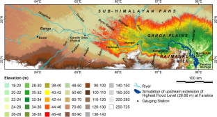
Flood is common in the sub-Himalayan plains of the Indian state of Bihar. During the massive flood of the Ganga between 18 and 31 August 2016, 15 (out of 38) districts and 3459 villages of the state were affected. The flood inundated 6006 km2 of area, harmed 8.82 million people, and caused damages worth US$ 73.99 million. To investigate the factors behind the event, we utilised SRTM elevation data and Landsat-8 OLI images to extract drainage networks and reservoirs of the region. Inundated area was delineated using MNDWI on MODIS data of 25-Aug-2016. Different hydrometeorological parameters employed in the study include percentage departure of monthly rainfall, discharge data of selected dams and barrages, and gauge data from six stations along a 526 km stretch of the Ganga: Buxar, Gandhi Ghat (Patna), Hathidah, Munger, Kahalgaon, and Manikchak Ghat. It was found that the flood was mainly caused by rapid release of water from the Bansagar Dam on the Son from 18 to 20-Aug-2016, as a tropical storm traversed through its upper catchment. Contributions from the Ganga’s Himalayan tributaries and upstream of the flooded area were negligible. The flood peak (50.52 m), recorded at Gandhi Ghat on 21 August 2016, passed downstream, and reached Manikchak Ghat (25.78 m) on 27–28 August 2016. The upstream extension of flooding due to the highest recorded flood level of 26.66 m of the Ganga at Farakka can only reach up to 6 km above Kahalgaon. Therefore, impoundment of the Ganga by the Farakka Barrage cannot have any impact on inundation of the areas above that limit and did not cause the 2016 floods.
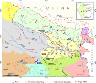


source: India Meteorological Department; Department of Hydrology and Meteorology, Govt. of Nepal)
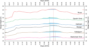
source: Water Resource Department, Govt. of Bihar; Irrigation and Waterways Department, Govt. of West Bengal)
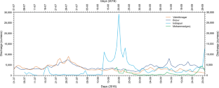
(Data source: Water Resource Department, Govt. of Bihar)
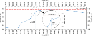
source: Water Resource Department, Govt. of Madhya Pradesh)
References
Agarwal A, Labh N, Nambi VA (1991) Nightmare in North Bihar. In: Agarwal A, Narain S (eds) State of India’s Environment, 3rd Citizens’ Report: Floods, Flood Plains and Environmental Myths. Centre for Science and Environment, New Delhi, pp 95–126
Bhatt CM, Rao GS, Manjushree P, Bhanumurthy V (2010) Space based disaster management of 2008 Kosi floods, North Bihar, India. J Indian Soc Remote Sens 38:99–108
Byrne J (1911) Bengal District Gazetteers: Bhagalpur. Bengal Secretariat Book Depot, Calcutta
Chandran RV, Ramakrishnan D, Chowdary VM, Jeyaram A, Jha AM (2006) Flood mapping and analysis using air-borne synthetic aperture radar: a case study of July 2004 flood in Baghmati river basin. Bihar Curr Sci 90(2):249–256
Che X, Feng M, Jiang H, Jia SJ, B, (2015) Downscaling MODIS surface reflectance to improve water body extraction. Adv Meteorol 2015:1–13. https://doi.org/10.1155/2015/424291
CRED: Centre for Research on the Epidemiology of Disasters (2018) Economic Losses, Poverty & Disasters: 1998–2017. https://www.unisdr.org/files/61119_credeconomiclosses.pdf. Accessed 4 Feb 2019
CWC: Central Water Commission (2018) State Wise Flood Damage Statistics. http://cwc.gov.in/sites/default/files/statewiseflooddatadamagestatistics.pdf. Accessed 4 Feb 2019
DFO: Dartmouth Flood Observatory (2016) River and reservoir watch ver. 3.8: River discharge and reservoir storage changes using satellite microwave radiometry. http://floodobservatory.colorado.edu/SiteDisplays/195data.htm. Accessed 16 May 2017
Dhar ON, Nandargi S (2002) Flood study of the Himalayan tributaries of the Ganga river. Meteorol Appl 9:63–68
Dhar ON, Nandargi S (2003) Hydrometeorological aspects of floods in India. Nat Hazards 28:1–33
DoDM-GoB: Department of Disaster Management, Govt. of Bihar (2016) Daily report on rainfall and flood. http://disastermgmt.bih.nic.in/. Accessed 11 May 2017
Ghosh T, Mukhopadhyay A (2014) Natural Hazard Zonation of Bihar (India) Using Geoinformatics: A Systematic Approach. Springer Briefs in Earth Science, Dordrecht
Guha Roy A (2016) Nitish meets Modi over Bihar flood, asks for Farakka barrage to be demolished. Hindustan Times. https://www.hindustantimes.com/india-news/nitish-meets-modi-over-bihar-flood-asks-for-farakka-barrage-to-be-demolished/story-kCmcaIAk3puJyKDQtxobgK.html. Accessed 11 Nov 2020
Hunter WW (1877) A Statistical Account of Bengal, vol 11: Patna and Saran. Trubner & Co., London
IMD: India Meteorological Department (2016) Deep Depression over the Bay of Bengal (16–21 August 2016): A Report. http://www.rsmcnewdelhi.imd.gov.in/images/pdf/publications/preliminary-report/ddaug.pdf Accessed 28 Aug 2017
Kale VS (2008) Himalayan catastrophe that engulfed North Bihar. J Geol Soc India 72:713–719
Langat PK, Kumar L, Koech R (2019) Monitoring river channel dynamics using remote sensing and GIS techniques. Geomorphology 325:92–102
Li L, Vrieling A, Skidmore A, Wang T, Muñoz A-R, Turak E (2015) Evaluation of MODIS spectral indices for monitoring hydrological dynamics of a small, seasonally-flooded wetland in Southern Spain. Wetlands 35(5):851–864
Mahapatra PK, Singh RD (2003) Flood management in India. Nat Hazards 28:131–143
Manjusree P, Bhatt CM, Begum A, Rao GS, Bhanumurthy V (2015) A decadal historical satellite data analysis for flood hazard evaluation: a case study of Bihar (North India). Singapore J Trop Geogr 36:308–323
Mazumdar SC (1953) Ganga barrage and the Bhagirathi Hooghly river problems. Indian J Power River Val Dev 3(3):5–22
Mazumder SK (2004) Role of Farakka barrage on the disastrous 1998 flood in Malda (West Bengal). In: Mirza MMQ (ed) The Ganges Water Dispersion: Environmental Effects and Implications. Kluwer Academic Publishers, Dordrecht, pp 39–48
Mishra D (2004) Bihar: Flooded and waterlogged. In: Subba B, Pradhan K (eds) Disputes over the Ganga. Panos Institute South Asia, Kathmandu, pp 92–122
MoWR-GoI: Ministry of Water Resources, Govt. of India (2014) Ganga Basin ver.2, Water Resources Information System of India. https://indiawris.gov.in/downloads/Ganga%20Basin.pdf. Accessed 12 Nov 2020.
O’Malley LSS (1907) Bengal District Gazetteers: Patna. The Bengal Secretariat Book Depot, Calcutta
Pandey AC, Singh SK, Nathawat MS (2010) Waterlogging and flood hazards vulnerability and risk assessment in Indo-Gangetic plain. Nat Hazards 55:273–289
Pandey RK, Crétaux J-F, Bergé-Nguyen M, Tiwari VM, Drolon V, Papa F, Calmant S (2014) Water level estimation by remote sensing for the 2008 flooding of the Kosi river. Int J Remote Sens 35(2):424–440
Parua PK (2010) The Ganga: Water Use in the Indian Subcontinent. Springer, Dordrecht
Purohit MK, Kaur S (2017) Rainfall Statistics of India—2016. Hydromet Division, India Meteorological Department, New Delhi http://hydro.imd.gov.in/hydrometweb/(S(0ymurl55bikbhgzupnyvnny0))/PRODUCTS/Publications/Rainfall%20Statistics%20of%20India%20-%202016/Rainfall%20Statistics%20of%20India%20-%202016.pdf Accessed 4 Feb 2019.
Reddy VD, Kumar D, Saha D, Mandal MK (2008) The 18 August 2008 Kosi river breach: an evaluation. Curr Sci 95(12):1668–1669
Roy Chaudhury PC (1962) Bihar District Gazetteers: Bhagalpur. Secretariat Press, Patna
SANDRP: South Asia Network on Dams, Rivers and People (2016) Remove inefficient Farakka Barrage: Bihar CM. https://sandrp.in/2016/07/18/drp-news-bulletin-18-july-2016-remove-inefficient-farakka-barrage-bihar-cm/ Accessed 11 Nov 2020
SCoWR-LSS: Standing Committee on Water Resources 2013–14, Lok Sabha Secretariat (2014) 21st Report: Review of Ganga Flood Control Commission. Ministry of Water Resources, Govt. of India. http://www.indiaenvironmentportal.org.in/files/file/Review%20of%20Ganga%20Flood%20Control%20Commission.pdf Accessed 20 Nov 2018
Sharma VK, Priya T (2001) Development strategies for flood prone areas, case study: Patna. India Disaster Prev Manag 10(2):101–109
Singh A (2016a) Bansagar stops discharge, helps ease situation. Times of India. https://timesofindia.indiatimes.com/city/patna/Bansagar-stops-discharge-helps-ease-situation/articleshow/53816638.cms. Accessed 10 Jan 2017
Singh RK (2016b) Nitish Kumar blames Farakka dam for floods, writes to PM Modi calling for it's demolition. India Today. https://www.indiatoday.in/india/story/bihar-floods-nitish-kumar-farraka-dam-center-plea-demolition-336828-2016-08-23. Accessed 11 Nov 2020
Singh DS, Awasthi A (2011) Natural hazards in the Ghaghara river area, Ganga Plain, India. Nat Hazards 57:213–225
Singh O, Kumar M (2013) Flood events, fatalities and damages in India from 1978 to 2006. Nat Hazards 69(3):1815–1834
Sinha R (1998) On the controls of fluvial hazards in the North Bihar plains, Eastern India. In: Maund JG, Eddleston M (eds) Geohazards in Engineering Geology. Geol Soc, London, Eng Geol Spl Pub vol 15, pp 35–40
Sinha CP (2008) Management of floods in Bihar. Econ Polit Weekly 43(46):40–42
Sinha R (2009) The great avulsion of Kosi on 18 August 2008. Curr Sci 97(3):429–433
Sinha R, Jain V (1998) Flood hazards of North Bihar rivers, Indo-Gangetic Plains. Mem Geol Soc India 41:27–52
Sinha R, Bapalu GV, Singh LK, Rath B (2008) Flood risk analysis in the Kosi river basin, North Bihar using multi-parametric approach of Analytical Hierarchy Process (AHP). J Indian Soc Remote Sens 36:335–349
Sinha R, Gaurav K, Chandra S, Tandon SK (2013) Exploring the channel connectivity structure of the August 2008 avulsion belt of the Kosi river, India: application to flood risk assessment. Geology 41(10):1099–1102
Sinha R, Sripriyanka K, Jain V, Mukul M (2014) Avulsion threshold and planform dynamics of the Kosi river in North Bihar (India) and Nepal: a GIS framework. Geomorphology 216:157–170
Slater JA, Garvey G, Johnston C, Haase J, Heady B, Kroenung G, Little J (2006) The SRTM data “finishing” process and products. Photogramm Eng Remote Sens 72(3):237–247
Szabó S, Gácsi Z, Balázs B (2016) Specific features of NDVI, NDWI and MNDWI as reflected in land cover categories. Landsc Environ 10(3–4):194–202
ToI: Times of India (2016) 'Remove Farakka barrage', demands Nitish Kumar as flood situation in Bihar turns grim. https://timesofindia.indiatimes.com/india/Remove-Farakka-barrage-demands-Nitish Kumar-as-flood-situation-in-Bihar-turns-grim/articleshowprint/53799721.cms Accessed 02 Sept 2016
USGS: United States Geological Survey (2003) SRTM data editing rules, version 2.0. https://dds.cr.usgs.gov/srtm/version2_1/Documentation/SRTM_edit_rules.pdf Accessed 11 Nov 2020
Vishwakarma VD, Jain K, Sneeuw N, Devraju B (2013) Mumbai 2005, Bihar 2008 flood reflected in mass changes seen by GRACE satellites. J Indian Soc Remote Sens 41(3):687–695
WRD-GoB: Water Resource Department, Govt. of Bihar (2016) Daily flood bulletin. http://wrd.bih.nic.in/ Accessed 15 May 2017
WRD-GoMP: Water Resource Department, Govt. of Madhya Pradesh (2016) SMS based reservoir water level monitoring system. http://eims1.mpwrd.gov.in/fcmreport/control/reservoirLevelSearch Accessed 26 May 2017
Xu H (2006) Modification of normalised difference water index (NDWI) to enhance open water features in remotely sensed imagery. Int J Remote Sens 27(14):3025–3033
Zhai K, Wu X, Qin Y, Du P (2015) Comparison of surface water extraction performances of different classic water indices using OLI and TM imageries in different situations. Geo-spatial Inf Sci 18(1):32–42
Acknowledgements
The agencies from which various data were sourced in this article are thankfully acknowledged. Thanks are also due to Nabendu Sekhar Kar and Sayantan Das for various suggestions.
Author information
Authors and Affiliations
Corresponding author
Additional information
Publisher's Note
Springer Nature remains neutral with regard to jurisdictional claims in published maps and institutional affiliations.
Rights and permissions
About this article
Cite this article
Das, A., Santra, P.K. & Bandyopadhyay, S. The 2016 flood of Bihar, India: an analysis of its causes. Nat Hazards 107, 751–769 (2021). https://doi.org/10.1007/s11069-021-04604-0
Received:
Accepted:
Published:
Issue Date:
DOI: https://doi.org/10.1007/s11069-021-04604-0


