Abstract
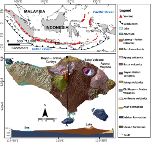
Bali island is part of the Sunda volcanic arc with an active volcano at its center. The Buyan-Bratan caldera, the Batur volcano, and the Agung volcano are active volcanoes aligned from the west to the east of the island of Bali. The activity and age of volcanoes progress eastward. Therefore, the physical properties and conditions of each body of magma beneath the volcanoes on the island of Bali requires investigation. Ground magnetic measurements were carried out throughout the island and integrated with the Bouguer anomaly map. Hand samples were taken that represented each lithology of Bali Island. Furthermore, magnetic susceptibility and density measurements were carried out, which were used as initial data for generating magnetic and gravity models. Apart from that, geological maps and previous geological and geophysical research in the Bali Island area were also used as supporting data to create magnetic and gravity models. Magnetic and gravity modeling shows a carbonate rock formation in Bali Island's southern volcanic area, surrounded by a graben up to 6 km deep and covered by volcanic deposits. Furthermore, magnetic and gravity models indicate an intrusive rock between Agung and Batur volcanoes as well as shallow and deep magma chambers beneath the Buyan-Bratan Caldera, Agung, and Batur volcanoes. The magnetic susceptibility and density differences from the magnetic and gravity models in this study are one way to trace the eastward shift in volcanic activity on Bali Island. These findings will contribute to better understanding the volcanic processes and the migration of volcanic centers, which can help volcanic and earthquake hazard mitigation.
Graphical abstract


Data availability
The raw data supporting the conclusions of this paper will be made available without restriction by the authors.
References
Albino F, Biggs J, Syahbana DK (2019) Dyke intrusion between neighboring arc volcanoes responsible for 2017 pre-eruptive seismic swarm at Agung. Nat Commun 10:748. https://doi.org/10.1038/s41467-019-08564-9
Amir H, Bijaksana S, Dahrin D, Nugraha AD, Arisbaya I, Pratama A, Suryanata PB (2021) Subsurface structure of Sumani segment in the Great Sumatran Fault inferred from magnetic and gravity modeling. Tectonophysics 821:229149. https://doi.org/10.1016/j.tecto.2021.229149
Ardianto A, Nugraha AD, Afif H, Syahbana DK, Sahara DP, Zulfakriza Z, Widiyantoro S, Priyono A, Rosalia S, Saepuloh A, Kasbani K, Muttaqy F, Rahsetyo P, Priambodo I, Martanto M (2021) Imaging the subsurface structure of Mount Agung in Bali (Indonesia) using volcano-tectonic (VT) earthquake tomography. Front Earth Sci 9:619587. https://doi.org/10.3389/feart.2021.619587
Austin J, Guena S, Clark D, Hillan D (2014) Remanence, self-demagnetization, and their ramifications for magnetic modelling of iron oxide copper-gold deposits: an example from Candelaria, Chile. J Appl Geophys 109:242–255. https://doi.org/10.1016/j.jappgeo.2014.08.002
Austria RSP, Parcutela NE, Reyes AML, Armada LT, Dimalanta CB, Yumul GP Jr (2022) Magnetic field characterization of Macolod Corridor (Luzon, Philippines): new perspectives on rifting in a volcanic arc setting. Tectonophysics 822:229179. https://doi.org/10.1016/j.tecto.2021.229179
Blakely RJ (1996) Potential theory in gravity, and magnetic applications. Cambridge University Press, Cambridge
Blakely RJ, Brocher TM, Wells RE (2005) Subduction-zone magnetic anomalies and implications for hydrated forearc mantle. Geology 33:445–448. https://doi.org/10.1130/G21447.1
Carter LB, Dasgupta R (2015) Hydrous basalt–limestone interaction at crustal conditions: implications for generation of ultracalcic melts and outflux of CO2 at volcanic arcs. Earth Planet Sci Lett 427:202–214. https://doi.org/10.1016/j.epsl.2015.06.053
Chen C-TA, Wang S-L, Bychkov AS (1995) Carbonate chemistry of the Sea of Japan. J Geophys Res 100:13737–13745. https://doi.org/10.1029/95JC00939
Chrapkiewicz K, Paulatto M, Heath BA, Hooft EEE, Nomikou P, Papazachos CB, Schmid F, Toomey DR, Warner MR, Morgan JV (2022) Magma chamber detected beneath an arc volcano with full-waveform inversion of active-source seismic data. Geochem Geophys Geosyst 23:e2022GC010475. https://doi.org/10.1029/2022GC010475
Dahrin D, Amir H, Suryanata PB, Bijaksana S, Fajar SJ, Ibrahim K, Harlianti U, Arisbaya I, Pebrian MQ, Rahman AA, Kasendri A (2022) Subsurface structures of Sianok Segment in the GSF (Great Sumatran Fault) inferred from magnetic and gravity modeling. Front Earth Sci 10:1012286. https://doi.org/10.3389/feart.2022.1012286
Deegan FM, Troll VR, Freeda C, Misiti V, Chadwick JP, Mcleod CL, Davidson JP (2010) Magma-carbonate interaction processes and associated CO2 release at Merapi Volcano, Indonesia: insights from experimental petrology. J Petrol 51:1027–1051. https://doi.org/10.1093/petrology/egq010
Dinc AN, Rabbel W, Flueh ER, Taylor W (2011) Mantle wedge hydration in Nicaragua from local earthquake tomography. Geophys J Int 186:99–112. https://doi.org/10.1111/j.1365-246X.2011.05041.x
Dorobek SL (2007) Carbonate-platform facies in volcanic-arc settings: characteristics and controls on deposition and stratigraphic development. Geol S Am S 436. https://doi.org/10.1130/2008.2436(04)
Dressel I, Barckhausen U, Heyde I (2018) A 3D gravity and magnetic model for the Entenschnabel area (German North Sea). Int J Earth Sci (geol Rundsch) 107:177–190. https://doi.org/10.1007/s00531-017-1481-x
Fontijn K, Costa F, Sutawidjaja I, Newhall CG, Herrin JS (2015) A 5000-year record of multiple highly explosive mafic eruptions from Gunung Agung (Bali, Indonesia): implications for eruption frequency and volcanic hazards. Bull Volcanol 77:59. https://doi.org/10.1007/s00445-015-0943-x
Fulthorpe CS, Schlanger SO (1989) Paleo-oceanographic and tectonic settings of early Miocene reefs and associated carbonates of offshore Southeast Asia. AAPG Bull 73:729–756. https://doi.org/10.1306/44B4A253-170A-11D7-8645000102C1865D
Geiger H, Troll V, Jolis E, Deegan F, Harris C, Hilton D, Freda C (2018) Multi-level magma plumbing at Agung and Batur volcanoes increases risk of hazardous eruptions. Sci Rep 8:10547. https://doi.org/10.1038/s41598-018-28125-2
Gill R (2010) Igneous rocks and processes: a practical guide. Wiley, Hoboken
Guevara-Betancourt R, Yutsis V, Varley N, Almaguer J, Alvarez R, Calderón-Moctezuma A, Sieck P (2023) Insights into the plumbing system of Colima Volcanic Complex from geophysical evidence. J Volcanol Geotherm Res 433:107711. https://doi.org/10.1016/j.jvolgeores.2022.107711
Gunawan MT, Kusnandar R, Supendi P, Nugraha AD, Puspito NT, Daryono, Sahara DP, Zulfakriza (2020) Analysis of swarm earthquakes around Mt. Agung Bali, Indonesia prior to November 2017 eruption using regional BMKG network. Geosci Lett 7:14. https://doi.org/10.1186/s40562-020-00163-7
Harbury NA, Kallagher HJ (1991) The Sunda Outer-Arc Ridge, North Sumatra, Indonesia. J Southest Asian Earth 6:463–476. https://doi.org/10.1016/0743-9547(91)90088-F
Kang J-T, Qi Y-H, Li K, Bai J-H, Yu H-M, Zheng W, Zhang Z-F, Huang F (2021) Calcium isotope compositions of arc magmas: implications for Ca and carbonate recycling in subduction zones. Geochim Cosmochim Acta 306:1–19. https://doi.org/10.1016/j.gca.2021.05.014
Kusuma DS, Purwoko E, Marpaung H, Suprapto SJ (2012) Peta Anomali Bouguer Daerah Panas Bumi Gunung Batur, Kecamatan Kintamani, Kabupaten Bangli, Provinsi Bali. Kelompok Program Penelitian Bawah Permukaan, Pusat Sumber Daya Geologi, Badan Geologi.
Lee C-TA, Shen B, Slotnick BS, Liao K, Dickens GR, Yokoyama Y, Lenardic A, Dasgupta R, Jellinek M, Lackey JS, Schneider T, Tice MM (2013) Continental arc–island arc fluctuations, growth of crustal carbonates, and long-term climate change. Geosphere 9:21–36. https://doi.org/10.1130/GES00822.1
Lucero SEV, Prezzi C, Scheck-Wenderot M, Bott J, Dacal MLG, Balestrini FI, Vizan H (2021) 3D gravity modelling of Colorado and Claromecó basins: new evidence for the evolution of the southwestern margin of Gondwana. Int J Earth Sci (geol Rundsch) 110:2295–2313. https://doi.org/10.1007/s00531-020-01944-3
Marín-Ceŕon MI, Moriguti T, Makishima A, Nakamura E (2010) Slab decarbonation and CO2 recycling in the Southwestern Colombian volcanic arc. Geochim Cosmochim Acta 74:1104–1121. https://doi.org/10.1016/j.gca.2009.10.031
Mason E, Edmonds M, Turchyn AV (2017) Remobilization of crustal carbon may dominate volcanic arc emissions. Science 357:290–294. https://doi.org/10.1126/science.aan5049
Nobes DC, Atekwana EA (2018) Pitfalls in near-surface geophysical interpretation: challenging paradigms and misconceptions. Interpretation 6:SL1–SL9. https://doi.org/10.1190/INT-2017-0104.1
Okada H (1980) Sedimentary environments on and around island arcs: an example of the Japan Trench area. Precambrian Res 12:115–139. https://doi.org/10.1016/0301-9268(80)90026-1
Paulatto M, Hooft EEE, Chrapkiewicz K, Heath B, Toomey DR, Morgan JV (2022) Advances in seismic imaging of magma and crystal mush. Front Earth Sci 10:970131. https://doi.org/10.3389/feart.2022.970131
Prasetyo H (1992) The Bali-Flores Basin: geological transition from extensional to subsequent compressional deformation. In: Proceedings of the Indonesian petroleum association, 21st annual convention, vol 1. pp 455–478
Purbo-Hadiwidjojo MM, Samodra IL, Amin TC (1998) Peta Geologi Lembar Bali, Nusa Tenggara Edisi Kedua, Pusat Penelitian dan Pengembangan Geologi
Purnomo BJ, Pichler T (2015) Geothermal systems on the island of Bali, Indonesia. J Volcanol Geotherm Res 305:349–358. https://doi.org/10.1016/j.jvolgeores.2015.09.016
Reubi O, Nicholls IA (2004) Magmatic evolution at Batur volcanic field, Bali, Indonesia: petrological evidence for polybaric crystallization and implications for caldera—forming eruptions. J Volcanol Geother Res 138:345–369. https://doi.org/10.1016/j.jvolgeores.2004.07.009
Reubi O, Nicholls IA (2005) Structure and dynamics of a silicic magmatic system associated with Caldera-forming eruptions at Batur Volcanic Field, Bali, Indonesia. J Petrol 46:1367–1391. https://doi.org/10.1093/petrology/egi019
Ryu S, Kitagawa H, Nakamura E, Itaya T, Watanabe K (2013) K-Ar analyses of the post-caldera lavas of Bratan volcano in Bali Island, Indonesia—Ar isotope mass fractionation to light isotope enrichment. J Volcanol Geotherm Res 264:107–116. https://doi.org/10.1016/j.jvolgeores.2013.07.002
Sahara D, Rahsetyo P, Nugraha AD, Syahbana D, Widiyantoro S, Zulfakriza Z, Ardianto A, Baskara A, Rosalia S, Martanto M, Afif H (2021) Use of local seismic network in analysis of volcano-tectonic (VT) events preceding the 2017 Agung Volcano Eruption (Bali, Indonesia). Front Earth Sci 9:609801. https://doi.org/10.3389/feart.2021.619801
Saltus RW, Blakely RJ (2011) Unique geologic insights from “non-unique” gravity and magnetic interpretation. GSA Today 21:4–11. https://doi.org/10.1130/G136A.1
Simanjuntak J (1995) Gravity measurement report in the Buyan-Bratan Geothermal area, Bali Province. Department of Mining and Energy, Directorate General of Geology and Mineral Resources, Directorate of Volcanology
Soja CM (1996) Island-arc carbonates: characterization and recognition of ancient geologic record. Earth Sci Rev 41:31–65. https://doi.org/10.1016/0012-8252(96)00029-3
Suryanata PB, Bijaksana S, Abdurrachman M, Dahrin D, Pratama A, Ndari NRDW, Fajar SJ (2023) Preliminary petromagnetic study of 1849, 1926, 1963, 1968 and 1974 surface lavas from Batur Volcano, Bali, Indonesia: insight on the magmatic process of source and rock magnetic nature. Rudarsko-Geološko-Naftni Zbornik 38:31–40. https://doi.org/10.17794/rgn.2023.1.3
Sutawidjaja IS (2009) Ignimbrite analyses of Batur Caldera, Bali, based on 14C dating. J Geol Indonesia 4:189–202. https://doi.org/10.17014/ijog.vol4no3.20094
Sutawidjaja, IS, Chaniago, R, Kamal, S, Modjo, WS (1992) Geological map of Batur caldera, Bali, Indonesia. Volcanological Survey of Indonesia, Bandung
Syahbana DK, Kasbani K, Suantika G, Prambada O, Andreas AS, Saing SL (2019) The 2017–19 activity at Mount Agung in Bali (Indonesia): intense unrest, monitoring, crisis response, evacuation, and eruption. Sci Rep 9:8848. https://doi.org/10.1038/s41598-019-45295-9
Tada N, Ichihara H, Nakano M, Utsugi M, Koyama T, Kuwatani T, Baba K, Maeno F, Takagi A, Takeo M (2021) Magnetization structure of Nishinoshima volcano, Ogasawara Island arc, obtained from magnetic surveys using an unmanned aerial vehicle. J Volcanol Geotherm Res 419:107349. https://doi.org/10.1016/j.jvolgeores.2021.107349
Tsuno K, Dasgupta R, Danielson L, Righter K (2012) Flux of carbonate melt from deeply subducted pelitic sediments: Geophysical and geochemical implications for the source of Central American volcanic arc. Geophys Res Lett 39:L16307. https://doi.org/10.1029/2012GL052606
Untung M, Kridoharto P, Budijarto RM (1972) Complete Bouguer Gravity Map, Geological Survey of Indonesia
van der Werff W (1996) Variation in forearc basin development along the Sunda Arc, Indonesia. J Southest Asian Earth 14:331–349. https://doi.org/10.1016/S0743-9547(96)00068-2
van der Werff W, Prasetyo H, Kusnida D, van Weering TCE (1994) Seismic stratigraphy and Cenozoic evolution of the Lombok Forearc Basin, Eastern Sunda Arc. Mar Geol 117:119–134. https://doi.org/10.1016/0025-3227(94)90010-8
Watanabe K, Yamanaka T, Harijoko A, Saitra C, Warmada IW (2010) Caldera Activities in North Bali, Indonesia. J Southest Asian Appl Geol 2:283–290. https://doi.org/10.22146/JAG.7274
Wheller GE, Varne R (1986) Genesis of dacitic magmatism at Batur Volcano, Bali, Indonesia: implication for the origins of stratovolcano calderas. J Volcanol Geotherm Res 28:363–378. https://doi.org/10.1016/0377-0273(86)90031-4
Zubaidah T, Korte M, Mandea M, Hamoudi M (2014) New insights into regional tectonics of the Sunda-Banda Arcs region from integrated magnetic and gravity modelling. J Asian Earth Sci 80:172–184. https://doi.org/10.1016/j.jseaes.2013.11.013
Zulfakriza Z, Nugraha AD, Widiyantoro S, Cummins PR, Sahara DP, Rosalia S, Priyono A, Kasbani K, Syahbana DK, Priambodo IC, Martanto M, Ardianto A, Husni YM, Lesmana A, Kusumawati D, Prabowo BS (2020) Tomographic imaging of the Agung-Batur Volcano Complex, Bali, Indonesia, from the ambient seismic noise field. Front Earth Sci 8:43. https://doi.org/10.3389/feart.2020.00043
Acknowledgements
Permission to conduct field research at Batur Volcano was given by the BKSDA (Balai Konservasi Sumber Daya Alam, or the Natural Resource Conservation Centre) of Bali, Indonesia. Financial support was provided by the Ministry of Education, Culture, Research, and Technology of the Republic of Indonesia through the basic research scheme (Hibah Penelitian Dasar) and the Institut Teknologi Bandung through the Research, Community Service, and Innovation (PPMI) 2023 Scheme.
Author information
Authors and Affiliations
Contributions
PBS, SB, DD, and ADN conceived the study. All authors, except for DD, ADN, AP, HA, and DCN, participated in the field survey. PBS, SB, DD, ADN, IPRAP, AP, and HA processed, analyzed, and interpreted the data. PBS, IPRAP, NKTS, and AP collected the rock samples, while PBS measured their density and magnetic susceptibilities. PBS, SB, DD, ADN, SJF, UH, and DCN contributed to the preparation of the manuscript. All authors read and approved the final manuscript.
Corresponding author
Ethics declarations
Conflict of interest
The authors declare that they have no known competing financial interests or personal relationships that could have appeared to influence the work reported in this paper.
Rights and permissions
Springer Nature or its licensor (e.g. a society or other partner) holds exclusive rights to this article under a publishing agreement with the author(s) or other rightsholder(s); author self-archiving of the accepted manuscript version of this article is solely governed by the terms of such publishing agreement and applicable law.
About this article
Cite this article
Suryanata, P.B., Bijaksana, S., Dahrin, D. et al. Subsurface structure of Bali Island inferred from magnetic and gravity modeling: new insights into volcanic activity and migration of volcanic centers. Int J Earth Sci (Geol Rundsch) (2024). https://doi.org/10.1007/s00531-024-02398-7
Received:
Accepted:
Published:
DOI: https://doi.org/10.1007/s00531-024-02398-7


