
Abstract
The study aims to assess the landscape vulnerability to forest fire susceptibility of Rudraprayag district, India, using frequency ratio model. Firstly, forest-fire-affected pixels were identified by using normalized difference burning ratio and ground survey. A total of 19,834 forest fire pixels were identified; out of these, 14,876 (70%) pixels were used to generate forest fire susceptibility map and the remaining 4958 affected pixels (30%) were used to validate the susceptibility model. Twelve forest fire conditioning indicators were selected: slope angle, slope aspect, curvature, elevation, topographic wetness index, soil texture, land use/land cover, normalized difference moisture index, annual average rainfall, road buffer, distance from settlement and distance from drainage to build the forest fire susceptibility model. Receiver operating characteristic curve was used to validate the forest fire susceptibility map, and 85% prediction accuracy was found. Final landscape vulnerability to forest fire susceptibility was assessed by using overlay function in GIS environment. The result shows that 73% area of Rudraprayag district falls into low and moderate susceptibility classes and approximately 16% area falls into high and very high susceptibility classes. Landscape vulnerability analysis revealed that moderate and very high forest fire susceptibility occupies the inaccessible parts of the core forest area of the district.


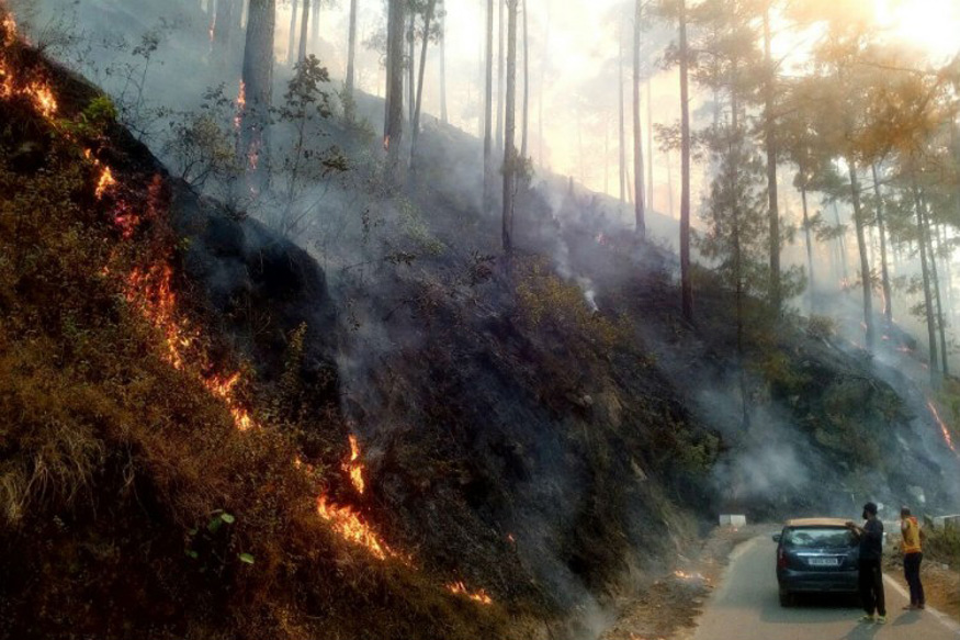
Source a http://www.indiatimes.com/news/india/uttrakhand-forest-fire-claims-five-lives-even-as-government-steps-up-effort-to-bring-it-under-control-254290.html, b http://img01.ibnlive.in/ibnlive/uploads/2016/05/UTTARAKHAND_FIRE.jpg, c http://indiatoday.intoday.in/story/uttarakhand-forest-fires-latest-updates-iaf-choppers-3-000-hectares-of-jungles-destroyed/1/656717.html, d http://www.ndtv.com/india-news/uttarakhand-forest-fire-governor-seeks-deployment-of-ndrf-companies-1401086, e http://www.deccanchronicle.com/nation/current-affairs/020516/uttarakhand-forest-fire-controlled-kiren-rijiju.html, f http://www.hindustantimes.com/india/4-people-arrested-for-starting-forest-fires-in-uttarakhand-number-of-incidents-down/story-pK6mAbgn7D6LipztAXs67K.html


References
Adab H, Kanniah KD, Solaimani K (2013) Modeling forest fire risk in the northeast of Iran using remote sensing and GIS techniques. Nat Hazards 65:1723–1743. doi:10.1007/s11069-012-0450-8
Anderson HE (1982) Aids to determining fuel models for estimating fire behavior. USDA For. Serv. Gen. Tech. Rep. INT-122, Ogden, Utah
Aniya M (1985) Landslide-susceptibility mapping in the Amahata River Basin, Japan. Ann Assoc Am Geogr 75(1):102–114
Berkes F, Folke C (1998) Linking social and ecological systems: management practices and social mechanisms for building resilience. Cambridge University Press, New York
Beven KJ, Kirkby MJ (1979) A physically based, variable contributing area model of basin hydrology. Hydrolol Sci Bull 24:43–69
Bhandary U, Muller B (2009) Land use planning and wildfire risk mitigation: an analysis of wildfire-burned subdivisions using high-resolution remote sensing imagery and GIS data. J Environ Plan Manag 52(7):939–955
Bottarelli E, Parodi S (2003) Un approccio per la valutazione della validit`a dei test diagnostici: le curve R.O.C. (Receiver Operating Characteristic). Ann Fac Medic Vet di Parma 5:49–68
Boudreau S, Lawes MJ, Piper SE, Phadima LJ (2005) Subsistence harvesting of pole-size understorey species from Ongoye Forest Reserve, South Africa: species preference, harvest intensity, and social correlates. For Ecol Manag 216:149–165
Castro R, Chuvieco E (1998) Modeling forest fire danger from geographic information systems. Geocarto Int 13(1):15–23. doi:10.1080/10106049809354624
Cayuela L, Rey-Benayas JM, Echeverria C (2006) Clearance and fragmentation of tropical Montane Forests in the highlands of Chiapas, Mexico (1975–2000). For Ecol Manag 226:208–218
Census of India (2011) Primary census abstract, census of India. Govt. of India, New Delhi
Chandra S, Arora MK (2006) Forest fire risk zonation mapping using remote sensing technology. Proc SPIE Int Soc Opt Eng. doi:10.1117/12.694228
Chomitz KM, Gray DA (1996) Roads, land use, and deforestation: a spatial model applied to Belize. World Bank Econ Rev 10:487–512
Chomitz, Kenneth M, Gray AD (1996) Roads, lands, markets, and deforestation: a spatial model of land use in Belize. Policy Research Working Paper 1444. World Bank, Policy Research Department, Washington, D.C. Processed
Chuvieco E (2003) Wildland fire danger estimation and mapping: the role of remote sensing data. World Scientific Publishing Co., River Edge
Chuvieco E, Congalton RG (1988) Mapping and inventory of forest fires from digital processing of TM data. Geoearto Int 4:41–53
Dieu TB, Owe L, Inge R, Oystein D (2011) Landslide susceptibility analysis in the Hoa Binh province of Vietnam using statistical index and logistic regression. Nat Hazards 59:1413–1444. doi:10.1007/s11069-011-9844
Egan JP (1975) Signal detection theory and ROC analysis. Academic Press, New York
Fawcett T (2006) An introduction to ROC analysis. Pattern Recognit Lett 27:861–874
Fernández DS, Lutz MA (2010) Urban flood hazard zoning in Tucumán Province, Argentina, using GIS and multi criteria decision analysis. Eng Geol 111:90–98
Frair JL, Merrill EH, Beyer HL, Morales JM (2008) Thresholds in landscape connectivity and mortality risks in response to growing road networks. J Appl Ecol 45:1504–1513
Glenn EP, Zamora-Arroyo F, Nagler PL, Briggs M, Shaw W, Flessa K (2001) Ecology and conservation biology of the Colorado River Delta, Mexico. J Arid Environ 49(5):15
Gorsevski PV, Gessler PE, Foltz RB, Elliot WJ (2006) Spatial prediction of landslide hazard using logistic regression and ROC analysis. Trans GIS 10(3):395–415
Hanley JA, McNeil BJ (1982) The meaning and use of the area under a receiver operating characteristic (ROC) curve. Radiology 143:29–36
Holling CS, Schindler DW, Walker BW, Roughgarden J (1995) Biodiversity in the functioning of ecosystems: an ecological synthesis. In: Perrings C, Mäler K-G, Folke C, Holling CS, Jansson B-O (eds) Biodiversity loss: economic and ecological issues. Cambridge University, New York, pp 44–83
Iwan R, Limberg G, Moeliono M, Sudana M, Wollenberg E (2004) Mobilizing community conservation: a community initiative to protect its forest against logging in Indonesia. Paper presented at the Xth Meeting of the International Association for the Study of Common Property, 9–13 August 2004, Oaxaca, Mexico
Jain A, Ravan SA, Singh RK, Das KK, Roy PS (1996) Forest fire risk modeling using remote sensing and geographic information system. Curr Sci 70(10):928–933
Jaiswal RK, Mukherjee S, Raju KD, Saxena R (2002) Forest fire risk zone mapping from satellite imagery and GIS. Int J Appl Earth Obs Geoinf 4(1):1–10. doi:10.1016/s0303-2434(02)00006-5
John P (1992) Effects of fire on forest ecology: fire and biodiversity. In: Canadian Institute of Forestry Annual Meeting, Vancouver, p 6
Kimothi MM, Jadhav RN (1998) Forest fire in the central Himalaya: an extent, direction and spread using IRS, LISS-I data. Int J Remote Sens 19(12):2261–2274
Krueger, E, Ochsner S, Tyson E, Engle E, David M, Carlson J, Twidwell, D, Fuhlendorf D, Samuel D (2015) Soil moisture affects growing-season wildfire size in the Southern Great Plains. Agronomy & Horticulture—Faculty Publications, 838
Kunwar P, Kachhawaha TS (2003) Spatial distribution of area affected by forest fire in Uttaranchal using remote sensing and GIS techniques. J Indian Soc Remote Sens 31(3):145–148
Kushla JD, Ripple WJ (1997) The role of terrain in a fire mosaic of a temperate coniferous forest. For Ecol Manag 95(1997):97–107
Lusted LB (1971) Signal detectability and medical decision-making. Science 171:1217–1219
Magliulo P, Di-Lisio A, Russo F, Zelano A (2008) Geomorphology and landslide susceptibility assessment using GIS and bivariate statistics: a case study in southern Italy. Nat Hazards 47:411–435. doi:10.1007/s11069-008-9230-x
Moore ID, Grayson RB, Ladson AR (1991) Digital terrain modeling—a review of hydrological, geomorphological, and biological applications. Hydrol Process 5:3–30
Nandi A, Shakoor A (2009) A GIS-based landslide susceptibility evaluation using bivariate and multivariate statistical analyses. Eng Geol 110:11–20
Nefeslioglu HA, Gokceoglu C, Sonmez H (2008) An assessment on the use of logistic regression and artificial neural networks with different sampling strategies for the preparation of soil erosion susceptibility maps. Eng Geol 97(3):171–191
Noonan M (2003) Recent language contact in the Nepal Himalaya. In: Bradley D, LaPolla R, Michailovsky B, Thurgood G (eds) Language variation: papers on variation and change in the Sinosphere and in the Indosphere in honour of James A. Matisoff. Pacific Linguistics, Canberra
Nowak DJ, Walton JT (2005) Projected urban growth (2000–2005) and its estimated impact on the US forest resource. J For 103:383–389
Pellizzaro G, Cesaraccio C, Duce P, Ventura A, Zara P (2007) Relationships between seasonal patterns of live fuel moisture and meteorological drought indices for Mediterranean shrubland species. Int J Wildland Fire 16:232–241. doi:10.1071/WF06081
Poudyal NC, Siry J, Bowker JM (2010) Urban forest’s potential to supply marketable carbon emission offsets: a survey of municipal governments in the United States. For Policy Econ 12:432–438
Pourghasemi HR (2015) GIS-based forest fire susceptibility mapping in Iran: a comparison between evidential belief function and binary logistic regression models. Scand J For Res. doi:10.1080/02827581.2015.1052750
Pourtaghi ZS, Pourghasemi HR (2014) GIS-based groundwater spring potential assessment and mapping in the Birjand Township, southern Khorasan Province, Iran. Hydrogeology. doi:10.1007/s10040-013-1089-6
Pourtaghi ZS, Pourghasemi HR, Rossi M (2015) Forest fire susceptibility mapping in the Minudasht forests, Golestan province. Environ Earth Sci 73:1515–1533. doi:10.1007/s12665-014-3502-4
Prasad RK, Mondal NC, Banerjee P, Nandakumar MV, Singh VS (2008) Deciphering potential groundwater zone in hard rock through the application of GIS. Environ Geol 55:467–475
Prosper-Laget V, Douguedroit A, Guinot J (1998) A satellite index of risk of forest fire occurrence in summer in the Mediterranean area. Int J Wildland Fire 8:173–182. doi:10.1071/WF9980173
Román-Cuesta RM, Retana J, Gracia M (2004) Fire trends in tropical Mexico: a case study of Chiapas. J For 102(1):26–32
Rowell A, Moore PF (1999) WWF/IUCN Global review of forest fires. Metis Associates, New York
Saklani P (2008) Forest fire risk zonation, a case study of Pauri Garhwal, Uttarakhand, India. M.Sc. Thesis. International Institute for Geoinformation Science and Earth Observation Enschede of the Netherlands and Indian Institute of Remote Sensing (NRSA) Dehradun India, p 71
Shafiei AB, Akbarinia M, Jalali GH, Alijanpour A (2010) Effect of forest fire on diameter growth of beech (Fagus orientalis Lipsky) and hornbeam (Carpinus betulus L.): a case study in Kheyroud forest. Iran J For Poplar Res 17:464–474
Silver WL, Lugo AE, Keller M (1999) Soil oxygen availability and biogeochemistry along rainfall and topographic gradients in upland wet tropical forest soils. Biogeochemistry 44:301–328
Singh RP, Ajay K (2013) Fire Risk Zone Assessment in Chitrakoot Area, Satna MP, India. Res J Agric For Sci 1(5):1–4
Skibba R (2015) Assessing U.S. fire risks using soil moisture satellite data. Eos 96. doi:10.1029/2015EO042071. Published on 17 December 2015
Somashekar RK, Nagaraja BC, Urs K (2008) Monitoring of forest fires in Bhadra Wildlife Sanctuary. J Indian Soc Remote Sens 36(1):99–104
Somashekar RK, Ravikumar P, Mohan-Kumar CN, Prakash KL, Nagaraja BC (2009) Burnt area mapping of Bandipur National Park, India using IRS 1C/1D LISS III Data. J Ind Soc Remote Sens 37:37–50
State of Forest Report (2015) Published by Forest Survey of India (Ministry of Environment & Forests) Kaulagarh Road, P.O IPE Dehradun-248195 India
Swets JA (1988) Measuring the accuracy of diagnostic systems. Science 240:1285–1293
Thakur AK, Singh D (2014) Forest fire risk zonation using geospatial techniques and analytic hierarchy process in Dehradun district, Uttarakhand, India. Univ J Environ Res Technol 4(2):82–89. eISSN 2249 0256
Turner MG, Carpenter SR, Gustafson EJ, Naiman RJ, Pearson SM (1998) Land use. In: Mac MJ, Opler PA, Doran P (eds) Factors influencing succession: Lessons from large, infrequent natural disturbances. Ecosystems 1:511–523
Weise DR, Biging GS (1994) Wind and slope-induced wild land fire behavior. In: Kashiwagi T (ed) Proceedings, 4th international symposium on fire safety science, 13–17 June 1994, Ottawa, Ont., pp 1041–1051
Williams CJ, Lee SS, Fisher RA, Dickerman LH (1999) A comparison of statistical methods for prenatal screening for Down syndrome. Appl Stoch Models Data Anal 15:89–101
Wilson JP, Gallant JC (2000) Terrain analysis, principles and applications. Wiley, New York, p 479
Wulder MA, Franklin SE (2006) Understanding forest disturbance and spatial pattern: remote sensing and GIS approaches. CRC Press Illustrations ISBN 9780849334252—CAT# 3425
Zhang Q, Devers D, Desch A, Justice CO, Townshend J (2005) Mapping tropical deforestation in central Africa. Environ Monit Assess 101:69–83
Zweig MH, Campbell G (1993) Receiver operating characteristic plots: a fundamental evaluation tool in clinical medicine. Clin Chem 39(4):561–577
Acknowledgement
The authors are highly thankful to USGS for providing free Landsat data downloaded via USGS EarthExplorer which has been used in this study. We would also like to thank organizations like National Bureau of Soil Survey and Land Use Planning, India, Survey of India, Indian Meteorological Department (IMD) for using their data in the present study. We are very thankful to the anonymous reviewers and the editor in Chief of Environmental Earth Sciences James W. LaMoreaux, for their valuable comments and suggestions for improving the manuscript. We would also like to thank local communities (Villagers) of Rudraprayag district for accompanying us to different places in mountainous areas during the field survey to different fire affected areas in forests. Thanks are also due to Forest Department of Uttarakhand State for granting us the permission to visit the fire affected areas in the forests. We are also very thankful to different news media like India Times, IBN live, India Today, NDTV, Deccan Chronicle, Hindustan Times for using their photographs taken at the time of the fire events in Uttarakhand forests during Spring season (2016) which have been used in this paper.
Author information
Authors and Affiliations
Corresponding author
Ethics declarations
Conflict of interest
The authors declare that they have no conflict of interest.
Funding
No funding was received from any agency for conducting this study.
Rights and permissions
About this article

Cite this article
Sahana, M., Ganaie, T.A. GIS-based landscape vulnerability assessment to forest fire susceptibility of Rudraprayag district, Uttarakhand, India. Environ Earth Sci 76, 676 (2017). https://doi.org/10.1007/s12665-017-7008-8
Received:
Accepted:
Published:
DOI: https://doi.org/10.1007/s12665-017-7008-8