
Abstract
Floods are frequent hazard in Algeria. They cause severe casualties, destroy infrastructures, and impair economies. In the past decades, Algeria experienced devastating floods. The dominant type of occurring floods are flash floods, which tend to be not well documented and studied in Algeria. This chapter presents a brief introduction to the flood phenomena within the Algerian climatic and management context, based on databases, scientific publications, and local technical reports. Existing studies about floods are reviewed. It also provides an analysis of the most disastrous floods that occurred in the past decades. Of the most noteworthy flash floods, a highlight of the Bab El Oued flash flood occurring in a heavily urbanized setting and the M’zab Valley flash flood, which took place in a UNESCO World Heritage Site. The monitoring network in Algeria is presented and data availability is discussed. The implementation of the first forecasting and early warning system are also presented. Different aspects of flash floods were presented including the effect of the increase of urbanization, the influence of climate change and the adopted strategies of flood risk management. Heavy and increasing urbanization and population growth increased the flood vulnerability and this trend must be mitigated.
You have full access to this open access chapter, Download chapter PDF
Keywords
1 Introduction
Floods are a worldwide natural phenomenon and are considered as one of the most severe weather-related disasters. They can damage societies, impair economies, harm the environment, and cause tragic human casualties. 47% of all weather-related disasters are caused by floods, impacting 2,3 billion persons, and killing 156,000 others with estimated economic losses of 662 billion (US $).
In recent decades, occurring floods were dominated by devastating flash floods especially observed in Mediterranean countries (Gaume et al. 2016; Llasat et al. 2013, 2010) and the MENA zone (WorldBank 2014). From 1900 to 2011, 15 MENA countries were affected by 213 floods, killing almost 19,000 peoples and impacting 8.6 million others. Flash floods are also generated by extreme rainfall over a short time period (Price et al. 2011)
Floods have been a permanent scientific interest with many developments done in different associated relating topics. The main challenge of scientists is to better understand the phenomenon and develop a model strategy for flood risk management. Several instructive reviews dealing with floods appeared: (Hammond et al. 2015; Mignot et al. 2019; Nkwunonwo et al. 2020; Teng et al. 2017).
Llasat et al. (2010) and Gaume et al. (2016) have collected and analyzed information about 55 events of extreme floods that happened during the period between 1990 and 2006 and 172 extreme flood events (period 1940–2015) respectively in Mediterranean countries. They found a contrast in the magnitude and impact of extreme events between the West and East parts of Mediterranean region. Floods occur in Northern Africa with reduced frequencies, but with a high number of fatalities, they are often devastating. The most dramatic event in Mediterranean and MENA regions occurred in Algiers (2001, 900 killed) (Gaume et al. 2016).
Algeria is part of MENA countries and the most exposed to natural disasters (62 hazards, between 1980 and 2010) with 58% of them as floods (WorldBank 2014). Floods are among the most important natural hazards in Algeria. Significant fatalities, damage to buildings, and the loss of roads and urban infrastructure have been induced.
In this chapter, the focus is made on the flood analysis and mitigation strategies in Algeria: what is known and what can be done. A synthesis of several scientific publications and research projects on this theme is presented. Different aspects of flood analysis and their evolution in relation to urbanization and climate change are discussed.
2 Reviewed Studies on Floods
The flood research is the first step to a better comprehension of the phenomenon for improving management. It needs a good study of meteorological data and climate change, in particular precipitation, and good knowledge of the vulnerability of watersheds and cities and exposure to flooding in those territories to tackle flood problems (Loudyi and Kantoush 2020). The studies reporting the floods in Algeria are increasing in recent years. This research focused on three themes: (1) flood hazard mapping, (2) hydraulic and hydrologic modelling (3) some specific flood event analysis (Table 3.1).
Several studies have been carried out with the aim of generating flood risk maps based on hydrological and hydraulic simulation (Astite et al. 2015; Yamani et al. 2016; Abdessamed and Abderrazak 2019 and Hafnaoui et al. 2020) or hydrogeomorphological approach (Cheikh lounis et al. 2015; ZaÏri 2018; Mimouni et al. 2019; Bourenane et al. 2019). By using PLUTON as a hydrological model and HecRas for flood simulation, Astite et al. (2015) delimitated flood risk areas in El Harrach river, the most important in Algiers city. Several flooding events resulting from the growth of the population and municipalities expansion over the natural space of El-Harrach River, have been identified in this coastal region. On the semiarid Ain-Sَafra River, which is located in Southwest of Algeria, a similar study was carried out (Abdessamed and Abderrazak 2019). The simulation was also carried out for the purpose of testing the retaining concrete walls built by local officials, as well as other proposed security measures. Results showed that for 100-years floods there are some overflows, although the measures given remain insufficient for 1000-years. Both studies (Astite et al. 2015 and Abdessamed and Abderrazak 2019) were focused on the frequency related to return periods to indicate flooded zones, furthermore, Hafnaoui et al. (2020) have proposed a system based on the suggested values of rainfall. (40, 60, 80, and 100 mm) to identify flood-prone zones. The idea was to use the flood hazard map with weather warnings released by the National Office of Meteorology (NOM) in order to identify the area exposed to flood. Contrary to the simulated flood using mostly the HecRas software, Bourenane et al. (2019) performed an investigation based mainly on field survey, aerial photographs, and satellite images analyze in addition of other information sources to identify the flood plains of historical events. The use of such approaches is more effective since it is based on real events (historical floods), contrary to the first approach (hydrological and hydraulic simulation) which is based on projected events and unperfect models. However, the hydrogeological approach requires an enormous amount of data and more time, especially for the field survey.
The major observation is the missing of scientific contribution about urban flooding despite the prevalence of this type of flood. Urban sewer systems are not well studied, and only rural areas are analyzed. It could be due to the difficulty of this kind of study and the gap of available data.
The choice of the hydrological model is conditioned by the availability of climatic data. The hydrologic studies were just a statistical adjustment of time series or a simple rainfall-runoff transformation. The time step of available data is typically daily which is not suitable for rapidly occurring phenomenon. HEC-RAS, a 1-D Hydraulic model was commonly used and one of the simplest existing flood models. This simplicity is related to the considerable negligence of essential elements of flood hydraulics (Nkwunonwo et al. 2020).
The topographic information is generally extracted from low resolution (30 m × 30 m) digital elevation models (DEMs) given by SRTM products, which does not successfully capture the fluvio-morphological characteristics of the wadis that are narrow in nature.
Hydrological and hydraulic modelling of the flood inundation is an essential tool for better flood risk management. However, the unavailability of adequate data and detailed information needed by the researchers slows the flood modelling development in Algeria. These difficulties must be overcome firstly.
3 Flood Inventory in Algeria
The information about floods in this chapter was collected from different types of sources: technical reports, scientific publications, and databases. In order to inventory historical floods and their effects in Algeria, several works were carried out. They provide information about fatalities, a brief description of the induced damage, and refer to other characteristics of floods (rain, flow, and water depth). Sardou et al. (2016) developed a flood’s catalogue of north-western Algeria for the period between 1847 and 2014. They documented 127 events and found that 62.20% are classified as flash floods (Sardou et al. 2016).
The Civil Protection (CP) has the most complete information of occurred flood events since 1921. The main statistics of CP database are recapitulated in Fig. 3.1 and Table 3.2. Another inventory was produced and documented by the Algerian National Agency of Water Resources (ANRH) of the events from 1970 until 2000 (Lahlah 2000).

Evolution of the number of flood-related casualties in Algeria (CP database, period 1965–2013)
Other information was collected from the Dartmouth global archive of large flood events (dartmouth.edu) and the major flood events in FloodList (floodlist.com). Globally, information of events characteristics is partial and often not accurate. One of the EM-DAT criteria to qualify hazards as disastrous is that the number of casualties must exceed 10 (Gaume et al. 2016): Table 3.3 and (Fig. 3.2) present the disastrous floods in Algeria.

Monthly, seasonal, and regional distributions of the disastrous floods in Algeria (1965–2013)
By analyzing (Fig. 3.2), October is the month with the highest flood occurrence with 1141 recorded casualties (87% of the total death toll). In addition, most events are occurring in autumn and winter, appearing more frequently in the central regions of the country (Fig. 3.3).

Map of disastrous floods in Algeria (1965–2013)
ANRH agency classifies the main causes of floods in three major types: (i) exceptional weather situation (heavy rain, torrential rain), (ii) anthropogenic factors (iii) and geographic location (city crossed by Wadi or city at the foot of mountains). These three types are interconnected (Bahlouli 2010; Lahlah 2000). During the last decades, the Algerian authorities initiated 575 actions with an amount of 227 billion DZD (1.75 billion US$) to mitigate floods. Hundreds of cities and locations were protected and an important number of Wadis were managed (MRE 2018).
4 Notable Flash Floods in Algeria
The two catastrophic flash flood events that marked the country during the 2000s are the Bab El Oued flash flood (2001, urban flash floods) and the Wadi M’zab flash flood (2008, UNESCO World Heritage Site flash floods).
4.1 Bab El Oued Flash Flood (Urban Flash Flood)
Bab El Oued is a municipality of Algiers that is located on the northern coastal façade. From 9th to 10th of November 2001, Bab El Oued was devastated by the worst flash flood in the Mediterranean and MENA regions (Gaume et al. 2016). This disaster caused 900 fatalities, 423 injuries, and catastrophic material damages estimated to exceed 300 million US$. Of the 38 floods disasters that hit North Africa from 1975 until 2001, 31% of the casualties died in this flood (Brauch 2003). This sad record tells of the gravity of this disaster.
Bab El Oued district is at the output of the Wadi Koriche catchment (9 km2) (Fig. 3.4). This catchment is heavily urbanized in its downstream part and on the upstream ridges. Despite the inconvenient steep slopes, these areas were gradually urbanized in an uncontrolled manner (Fig. 3.5). Urbanization occupies approximately two-thirds of the watershed; the remaining third is occupied by forests and low vegetation areas (Menad et al. 2012).

Wadi Koriche catchment (Menad et al. 2012)

Land cover change in the Oued-Koriche catchment (Menad et al. 2012)
Algiers was struck by a heavy rain during 36 h reaching 263 mm (Bouzaréah rainfall station). If the rains with remarkable intensities seem to be frequent in this region, this rain accumulation which has been widely studied (Argence et al. 2006, 2008; Menad et al. 2012; Thomas et al. 2011), has never been recorded before since 1908 (Menad et al. 2012). The associated return period of this exceptional event is 200 years (Cheikhlounis et al. 2009).
Menad et al. (2012) using the reduced discharges method (Gaume et al. 2009), suggest the value of the specific flow as 9–14 m3/s/km2. According to Gaume et al. (2016), the extreme peak discharge of the Bab El Oued flash flood is the greatest in the Mediterranean region (Fig. 3.6).

The peak discharge of the Bab El Oued flash floods related to estimated world records since 1940 (Gaume et al. 2016)
There is an agreement that effects generated by the heavy rainstorm were accentuated by heavy urbanization, degradation of cover of vegetation, and accumulation on the slopes of earth embankments which constituted mudslides (Fig. 3.7). The sediment volume was estimated from 0.8 to 1 million m3 (Boutaoutaou 2007; Cheikhlounis et al. 2009; Menad et al. 2012).

Flash floods of Bab El Oued (November 10, 2001)
4.2 Wadi M’zab Flash Flood (UNESCO World Heritage Site)
Ghardaïa is situated about 600 km south of Algiers in northern-central Algeria and lies on the left bank of M’zab River (Fig. 3.8). In 1982, for its settlement influencing urban planning, for its Ibadi cultural values, and a settlement tradition that has prevailed to the present century, the M’zab valley was registered as cultural property under the UNESCO World Heritage List (Sub-catchment).

Wadi M’zab-Ghardaia region
Ghardaïa is one of the most-arid regions affected by floods. The region lived, in October 1st, 2008, an extreme flood with a maximum discharge of 1600 m3/s and a water depth exceeding 8 m (Fig. 3.9). Several studies in the literature can be found about this catastrophic event (Bendoudj et al. 2014; Bourenane et al. 2019; Yamani et al. 2016). This catastrophe resulted in an estimated number of 50 victims and 86 injured while leaving thousands homeless (MRE 2018).

Flash flood of Wadi M’zab in October 01, 2008
The damage would have been more dramatic if the alert had not been launched at 4 A.M. from the ancestral alert system called: Oumanaa Al Sayel (flash flood sentinel) which is a community-based system for the management of the watershed. This system was designed in 1273. It is a very ingenious hydraulic system based on the principle of full and fair exploitation of rain water and its accurate distribution in all oasis groves. It also includes towers and installations that enable permanent monitoring of floods to prevent flood hazards (Ali Taleb and Souad 2020; Benmamar et al. 2016; Khelifa and Remini 2019).
According to the ANRH agency, the measurements of precipitations in the two days of the event accumulated to 79.7 mm, almost equaling the yearly precipitation. Floods were caused by heavy rains generating a water accumulation along 2 km of wadis and mudslides overrun the riverbanks of Wadi M’Zab. The floods were aggravated when a dam break took place 20 km upstream of the city releasing more than 900 m3/s (Mimouni et al. 2019). The Algerian Space Agency (ASAL) has mapped the inundated areas of the event of October 1, 2008, using high-resolution satellite images and surface terrain model enhanced by GPS data (Benhamouda 2012) (Fig. 3.10).

Analysis and mapping of flooded areas in October 1st, 2008 (Benhamouda 2012)
The flood event value is extreme but still included in anticipated rainfall and discharge region statistics. The aggravation of the event comes from the huge amounts of deposits that raised the wadi bottom (1.50 m in some sections). The dam break had a secondary effect. Mimouni et al. (2019) concluded in their analysis of flood hazard of the Wadi M’zab valley, that there is an increase in the vulnerability due to the accelerating urbanization. This generates a serious problem in risk management. The ancestral alert system, despite being rudimentary and traditional, had a major role in reducing the damage.
5 Monitoring and Data Availability in Algeria
Algerian has an area of 2.38 million km2 and it is divided in 17 large hydrographic basins. Two national organizations have a network of monitoring stations (Figs. 3.12 and 3.14). The two organizations are the National Office of Meteorology (NOM) and the Algerian National Agency of Water Resources (ANRH).
The network wish is currently managed by ANRH (Taibi 2012) is made of:
-
220 hydrometric stations (water level, Discharge, Sediment Concentration, Salinity, Sampling for river water quality analysis).
-
50 complete climatological station.
-
200 rain gauges (Rainfall intensity).
-
860 rainfall stations (Daily rainfall).
The network is almost entirely manual. With a view to future improvement, the ANRH have undertaken the task to automate the stations so that data is easily collected and transmitted (Figs. 3.11 and 3.12).

An automatic station ANRH

Hydrometric stations in Algeria
The ONM uses the following networks and types of stations (Halimi 2016):
-
84 professional observation stations, thirty-two (32) of which are in aerodromes. This network is distributed according to the international standards of the World Meteorological Watch (V.M.M) networks.
-
300 Climatological stations, of which 100 are automatic stations.
-
07 weather radars (200 km, radius) distributed in the north of territory (Fig. 3.13). This network comes with satellite resources to complete the meteorological observation network for monitoring cloudy systems (oriented towards aviation hazards) and rainy systems for agriculture, hydrology, and civil protection (Keblouti et al. 2015) (Fig. 3.14).
Fig. 3.13 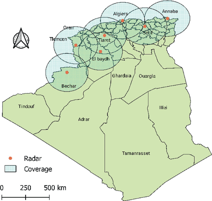
Algerian weather radar network
Fig. 3.14 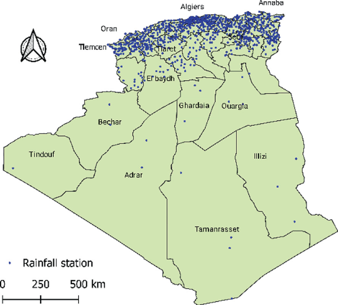
Rainfall stations in Algeria (ONM & ANRH)


The quality of the data obtained from these two sources is reliable that is considered being collected with the necessary rigor. There is a problem with the length of the historical datasets provided both from hydrometric and pluviometric monitoring networks. Monitoring stations tend to be frequently interrupted, decommissioned, or simply abandoned. This leads to the presence of discrepancies and the occurrence of randomized gaps in the datasets which limits the availability of long synchronous time-series to capture long-term patterns.
It is important to note that most of hydrometric stations are implemented outside of urban areas, intended for water resource management purposes. However, no monitoring systems are dedicated to flood measurements.
It would therefore be highly desirable to build a “national hydrometeorological network”, endowed with stable and sufficient human, material, and financial resources to ensure the sustainability of the activity as well as the reliable quality of the data. To this end, it is therefore essential to bring together all the means to ensure continuous operational maintenance of the network. It would also be appropriate to strengthen the radar network, will supplement precipitation data, for purposes of flood prevention, warning systems, and real-time flood monitoring.
6 Forecasting and Early Warning Systems
The Ministry of Water Resources (MRE) had a project intended to install warning systems in several cities of the country. The first operation of this type was initiated as a pilot project in Mekerra Basin and was implemented during the period 2009–2010 (Fig. 3.15).

Location of the Mekerra basin and its main gauging stations (Korichi et al. 2016)
A Flood Prediction Unit (UPI) has been established to manage flood forecasting processes in river basins. This unit is currently estimated to predict the floods of the Wadi Mekerra (basin of the Oued Mekerra), as a first step, then will be gradually generalized throughout the Algerian territory. Flood forecasting and warning systems integrate real-time management and data collection (automatic hydro-pluviometric stations) and apply and integrate hydrological and hydraulic models to provide forecasts of flows and levels. Water in the main sites of Oued Mekerra. The monitoring sytems is managed by ANRH.
The main goal of this project is to upscale rules and to establish procedures of flood risk forecasting and warning systems based on the results obtained and tested on a pilot case.
Flood Forecasting and Warning Monitoring Regulations exist nowadays which include:
-
The context of the pilot project,
-
The regulatory framework and the administrative framework,
-
The basic hydrological elements and the definition of alert levels, maps, and tables to be consulted in the event of an alert by the organs of the ORSEC plan (Algerian emergency plan), the structure of the UPI (Flood Prediction Unit), and all stakeholders in the alert procedure, the current activity of the UPI, the activation of a standby state,
-
The preparation of forecasts by the UPI on standby—alert communications, current data management—the relationship between the UPI and the ANRH including comments and recommendations.
Currently, according to the information collected, the system installed in Wadi Mekerra is not operational and no other system is installed.
7 Urbanization and the Increase in Vulnerability
Clearly, floods occur from natural processes, but they are not a natural disaster. Heavy rainfall is the flash floods trigger; all things considered, the damages depend on land use and expanded urbanization. The disasters that occurred in the last two decades showed the impact of urbanization in the improved cost of flash floods (Sect. 3.5).
Over time, Algeria has been subjected to rapid socio-economic modifications, which have resulted in urbanization concentration and population growth. The Algerian population expanded from about 11.3 million in 1960 to almost 43 million in 2019, quadrupling in 50 years. A disproportionate spatial redistribution has resulted in this demographic development. The population of the coastal areas and valleys is focused on the cities. In 2018, 90% of the population is located on 13% of the country’s area. The urbanization rate went from 30.5% in 1960 to 72% in 2019 (Fig. 3.16).

Population growth and changes in urbanization rate
Algeria experienced in the last decades, successive drought sequences and a higher urban need. Progressively, the limits of the wadis are unprotected, and urban settlement tend to occupy the wadi beds. In other cases, the main wadis-bed had been disturbed: piped, derived, or buried (Fig. 3.17). The increase in impervious areas results in changes in the hydrology of watershed (Shuster et al. 2005).

An example of the effect of urbanization: imperviousness anthropogenic influences generating a flood (Abdelmadjid et al. 2018)
The disastrous consequences were the result of inconsiderate occupation of wadi beds (Freddy et al. 2016). These changes have induced a highly imperviousness and anthropogenic influences and growth in the urban vulnerability.
8 Floods and Climate Change
The climate variability and climate change remain the main causes of the frequent recurrence of floods over time. Algeria is considered North Africa’s most sensitive country to climate change (Schilling et al. 2020). Several studies have been carried out on the assessment of climate change in some regions involving Algeria: (Tramblay et al. 2013)used an Extreme Precipitation (EP) index in the Maghreb region and concluded that in most stations, the rules of stationarity remain valid. The same conclusion has been reached by (Kharin et al. 2013) and (Ghenim and Megnounif 2016). In fact, the first showed that non-significant change occurred in EP by using Coupled Model Intercomparison Project 5 (CMIP5) models of global climate for the Representative Concentration Pathway (RCP) 8.5 scenarios, while the latter who studied the variability and trend of EP, found that no significant trend exists over 35 stations in northern Algeria. These findings support the idea that in Algeria, the EP is more influenced by local climatic processes and orography (Ghenim and Megnounif 2016; Tramblay et al. 2013).
9 Integrated Flood Risk Management Strategy in Algeria
The most human losses (1014, 77.64%) and economic damage occurred during the period between 2000 and 2011. This was a turning point for Algeria in flood protection. Consequently, the (MRE) has developed the National Flood Protection Strategy (NFPS) based on the deep analysis of the fifty most frequently flooded sites in different portions of the country. The NFPS categorized the flood types for the fifty sites as represented in (Fig. 3.18) (MRE 2018).

Types of floods in 50 most frequent flooded areas
Rapid floods can be considered a sub-category of flash floods. Noticeably 1/3 of flood events are a flash floods and 56% of the events have significant sediment depositing risk, which makes them more devastating. The NFPS identified 689 areas with potential flooding risk (MRE 2018). Five level risks were retained in the NFPS (Fig. 3.19).

Localization and classification of potential risk in the 689 areas
The NFPS promotes the Integrated Flood Risk Management (IFRM); as a strategic tool that allows an improved perception of the problem of flood risk management in a thorough and systematic manner (Fig. 3.20).

Summary of the IFRM
The IFRM is the main flood risk management policy adopted in Algeria for 2030. It encompasses the three main action areas, namely (i) preventive management measures (Preparation, Protection, Adaptation, Mitigation), (ii) control of the situation (limiting the extent of the phenomenon by managing the event), and (iii) recovery or post-flood measures to return to normal economic, social and environmental activity as quickly as possible (MRE 2018). The NFPS represents a major advance in the field of flood protection in Algeria.
10 Conclusion
The knowledge of floods, especially of flash floods is very limited in Algeria, such events are not well researched and documented in the country. This chapter aims to provide a clear insight and useful information on them for future studies.
Flood history in Algeria was recapped and the disastrous flood events were listed. Clearly, the country is very affected by floods with 1306 events and 1849 casualties. The most disastrous floods typically occur in autumn and winter, appearing more frequently in the central regions of the country. Information about floods is very important, which is why it is necessary to develop specific and detailed catalogs for historical floods. The two recent catastrophic flash floods are highlighted. The first is the Bab El Oued flash flood (2001). This is the deadliest event occurred in Mediterranean and MENA regions. This urban flash flood is an important case study. The second is the Wadi M’zab flash flood (2008) which occurred in UNESCO World Heritage Site of the valley of M’zab. The lesson to remember is that a rudimentary warning system can be very beneficial to reduce casualties.
In Algeria, 90% of population is concentrated in 13% of the country’s area. The population growth and increase in urbanization are the drivers of the increasing vulnerability. This trend is projected to continue until 2050 and its effects need to be mitigated. In Algeria, the influence of climate change on floods is inexistent. The extreme precipitation is more influenced by local climatic erratic processes and orography. Modelling of the flood inundation can be a helpful tool for a better flood risk management strategy. All studies focused on rural regions. The used approaches and selected models are limited by the data availability.
The National Floods Protection Strategy have a big challenge to promote the Integrated Flood Risk Management, adopted in 2018 as the main Policy for 2030.
References
Abbes ASB, Meddi M (2016) Study of propagation and floods routing in north-western region of Algeria. Int J Hydrol Sci Technol 6:118–142. https://doi.org/10.1504/ijhst.2016.075578
Abdelmadjid B, Lekouaghet I, Boutaghane H (2018) Protection study against the flooding of the city of Sidi Kassi-North East Algeria. Paper presented at the 4th International Symposium on Flash Floods in Wadi Systems, 04–06 December 2018, Casablanca, Morocco
Abdessamed D, Abderrazak B (2019) Coupling HEC-RAS and HEC-HMS in rainfall–runoff modeling and evaluating floodplain inundation maps in arid environments: case study of Ain Sefra city, Ksour Mountain. SW Algeria Environ Earth Sci 78:586. https://doi.org/10.1007/s12665-019-8604-6
Ali Taleb B, Souad B-L (2020) Quantitative analysis and efficiency assessment of floodwater harvesting system in Arid Region: case of Touzouz ephemeral stream. Mzab Valley Water Res 47:54–64. https://doi.org/10.1134/s0097807820010029
Argence S, Lambert D, Richard E, Söhne N, Chaboureau JP, Crépin F, Arbogast P (2006) High resolution numerical study of the Algiers 2001 flash flood: sensitivity to the upper-level potential vorticity anomaly. Adv Geosci 7:251–257. https://doi.org/10.5194/adgeo-7-251-2006
Argence S, Lambert D, Richard E, Chaboureau J-P, Söhne N (2008) Impact of initial condition uncertainties on the predictability of heavy rainfall in the Mediterranean: a case study. Q J R Meteorol Soc 134:1775–1788. https://doi.org/10.1002/qj.314
Astite S, Medjerab A, Belabid N, El Mahmouhi N, El Wartiti M, Kemmou S (2015) Cartography of flood hazard by overflowing rivers using hydraulic modeling and geographic information system: Oued El Harrach case (North of Algeria) Revista de Teledetección 44:67–79. https://doi.org/10.4995/raet.2015.3985
Atallah Mh, Hazzab A, Seddini A, Ghenaim A, Korichi K (2016) Hydraulic flood routing in an ephemeral channel: Wadi Mekerra. Algeria Model Earth Syst Environ 2:1–12. https://doi.org/10.1007/s40808-016-0237-0
Bahlouli L (2010) Majors risks related to water. In: CRSTRA (ed) Drought: analysis and strategies adaptation, pp 44–74. Biskra, Algeria 21 et 22 Novembre 2010 (In Frensh)
Bekhira A, Habi M, Morsli B (2018) Hydrological modeling of floods in the Wadi Bechar watershed and evaluation of the climate impact in arid zones (southwest of Algeria). Appl Water Sci 8:185. https://doi.org/10.1007/s13201-018-0834-3
Bendoudj A, Touaibia B, Hubert P (2014) Flood’s in the M’zab Valley (South Algeria): genesis and prediction. Le journal de l’eau et de l’environnement 24&25:20–34
Benhamouda F (2012) Spatial tool and GIS for flood prevention and management: experience and perspectives. In: Using space technology to serve the water sector, Alger, pp 18–30 (in Frensh)
Benmamar S, Poulard C, Berreksi A, Paquier A, Sioussiou R (2016) From the hydraulic system of ancestral M’Zab to Sustainable Urban Drainage Systems for the management of floods. Paper presented at the Novatech 2016, 9th International conference on Planning and technologies for sustainable URBAN WATER management, Lyon, France
Benmansour N, Haddouche D (2019) Deterministic modeling of the Mekerra wadi for the identification of the flood zone of Sidi Bel-Abbès (North-West Algeria) TSM 4:59–66. https://doi.org/10.1051/tsm/201904059
Boulghobra N (2012) The exceptional inundations of December 1984 in the Saf-Saf basin and Skikda city (North-eastern Algeria): Origins; spread and impacts Geographia Technica 7:14–22
Bourenane H, Bouhadad Y, Guettouche MS (2019) Flood hazard mapping in urban area using the hydrogeomorphological approach: case study of the Boumerzoug and Rhumel alluvial plains (Constantine city, NE Algeria). J Afr Earth Sci 160:103602. https://doi.org/10.1016/j.jafrearsci.2019.103602
Boutaoutaou D (2007) Debris flow and the Bab El Oued disaster. Paper presented at the Seminar on climate-related natural disasters, INRF, Oran, Algeria
Brauch HG (2003) Towards a fourth phase of research on human and environmental security and peace: conceptual conclusions. In: Security and Environment in the mediterranean. Springer-Verlag, pp 919–953
Cheikh lounis G, Chatelain JL, Mimouni O, Machane D (2015) Assessment of flood risk in Kniss Wadi catchment in Urbain Area Algiers—Algeria. In: Cham, 2015. Engineering geology for society and territory—volume 3. Springer International Publishing, pp 459–462
Cheikhlounis G, Machane D, Belhai D, Chatelain J-L, Dahmani K, Bichi N (2009) Floods and mudflows on November 11, 2001 in Bab El Oued, (Algiers). In: the 6th European congress on regional geoscientific cartography and information systems. Munich, pp 328–331
Freddy V, Saidi MEM, Douvinet J, Fehri N, Nasrallah W, Menad W, Mellas S (2016) Urbanization and land use as a driver of flood risk, pp 563–575
Gaume E et al (2009) A compilation of data on European flash floods. J Hydrol 367:70–78. https://doi.org/10.1016/j.jhydrol.2008.12.028
Gaume E, Borga M, Carmen Llasat M, Maouche S, Lang M, Diakakis M (2016) Mediterranean extreme floods and flash floods. In: The mediterranean region under climate change a scientific update. IRD Éditions, Marseille, France, pp 133–144. https://doi.org/10.4000/books.irdeditions.23181
Ghenim AN, Megnounif A (2016) Variability and trend of annual maximum daily rainfall in Northern Algeria. Int J Geophys 2016:6820397. https://doi.org/10.1155/2016/6820397
Hafnaoui MA, Madi M, Hachemi A, Farhi Y (2020) El Bayadh city against flash floods: case study. Urban Water J 1–6. https://doi.org/10.1080/1573062x.2020.1714671
Halimi L (2016) Presentation of the weather and climate observation network in Algeria availability of observed data. Paper presented at the climasouth seminar Algeria, Algeria, 11 et 12 Janvier 2016
Hammond MJ, Chen AS, Djordjević S, Butler D, Mark O (2015) Urban flood impact assessment: a state-of-the-art review. Urban Water J 12:14–29. https://doi.org/10.1080/1573062x.2013.857421
Hasbaia M, Adoui H, Paquier A (2015) Simulation of semiarid stream flow using the 1D model (Rubarbe), Case of Ksob Wadi in Algeria. Proc Environ Sci 25:120–126. https://doi.org/10.1016/j.proenv.2015.04.017
Keblouti M, Ouerdachi L, Berhail S (2015) The use of weather radar for rainfall-runoff modeling, case of Seybouse watershed (Algeria). Arab J Geosci 8:1–11. https://doi.org/10.1007/s12517-013-1224-7
Kharin VV, Zwiers FW, Zhang X, Wehner M (2013) Changes in temperature and precipitation extremes in the CMIP5 ensemble. Clim Change 119:345–357. https://doi.org/10.1007/s10584-013-0705-8
Khelifa A, Remini B (2019) The sharing of flood waters in the Ksours of Ghardaia and Berriane (Algeria) hydraulic study. GeoScience Eng LXV:44– 57. https://doi.org/10.35180/gse-2019-0011
Korichi K, Hazzab A, Atallah M (2016) Flash floods risk analysis in ephemeral streams: a case study on Wadi Mekerra (northwestern Algeria). Arab J Geosci 9:589. https://doi.org/10.1007/s12517-016-2624-2
Lahlah S (2000) Inventory of flood zones in Algeria—first approach
Lehbab-Boukezzi Z, Boukezzi L, Errih M (2016) Uncertainty analysis of HEC-HMS model using the GLUE method for flash flood forecasting of Mekerra watershed. Algeria Arab J Geosci 9:751. https://doi.org/10.1007/s12517-016-2771-5
Llasat MC et al (2010) High-impact floods and flash floods in Mediterranean countries: the FLASH preliminary database. Adv Geosci 23:47–55. https://doi.org/10.5194/adgeo-23-47-2010
Llasat MC, Llasat-Botija M, Petrucci O, Pasqua AA, Rosselló J, Vinet F, Boissier L (2013) Towards a database on societal impact of Mediterranean floods within the framework of the HYMEX project Nat Hazards Earth. Syst Sci 13:1337–1350. https://doi.org/10.5194/nhess-13-1337-2013
Loudyi D, Kantoush SA (2020) Flood risk management in the Middle East and North Africa (MENA) region. Urban Water J 17:379–380. https://doi.org/10.1080/1573062x.2020.1777754
Maref N, Seddini A (2018) Modeling of flood generation in semi-arid catchment using a spatially distributed model: case of study Wadi Mekerra catchment (Northwest Algeria). Arab J Geosci 11:116. https://doi.org/10.1007/s12517-018-3461-2
Menad W, Douvient J, Arnaud-Fassetta G (2012) Evaluating the influence of urbanised areas face to are markable meteorological hazard: the flood event of 9–10 November 2001 at Bab-el-Oued (Alger, Algeria). Géomorphol Relief Processus, Environn 3:337–350 (In French)
Mignot E, Li X, Dewals B (2019) Experimental modelling of urban flooding: a review. J Hydrol 568:334–342. https://doi.org/10.1016/j.jhydrol.2018.11.001
Mimouni O, Merchichi A, Lounis GC, Taleb B, Tahalaitit EH (2019) Flood hazard evaluation in Mzab Valley (Ghardaia—Algeria). In: Cham, 2019. IAEG/AEG annual meeting proceedings, San Francisco, California, 2018—volume 5. Springer International Publishing, pp 113–122
MRE (2018) Flood prevention strategy. Paper presented at the national meeting on disaster risk management, 22 et 23 Octobre 2018 (In Frensh)
Nkwunonwo UC, Whitworth M, Baily B (2020) A review of the current status of flood modelling for urban flood risk management in the developing countries. Sci Afr 7:e00269. https://doi.org/10.1016/j.sciaf.2020.e00269
Price C et al (2011) Using lightning data to better understand and predict flash floods in the Mediterranean. Surv Geophys 32:733. https://doi.org/10.1007/s10712-011-9146-y
Sardou M, Maouche S, Missoum H (2016) Compilation of historical floods catalog of northwestern Algeria: first step towards an atlas of extreme floods. Arab J Geosci 9:455. https://doi.org/10.1007/s12517-016-2490-y
Schilling J, Hertig E, Tramblay Y, Scheffran J (2020) Climate change vulnerability, water resources and social implications in North Africa. Reg Environ Change 20:15. https://doi.org/10.1007/s10113-020-01597-7
Shuster WD, Bonta J, Thurston H, Warnemuende E, Smith DR (2005) Impacts of impervious surface on watershed hydrology: a review. Urban Water J 2:263–275. https://doi.org/10.1080/15730620500386529
Taibi R (2012) Presentation of the ANRH ABH. http://www.abhcsm.dz/Comm_Coll_2012/Mr.TAIBI_Rachid_ANRH_Alg%C3%A9rie.pdf. Accessed 28/09/2020
Teng J, Jakeman AJ, Vaze J, Croke BFW, Dutta D, Kim S (2017) Flood inundation modelling: a review of methods, recent advances and uncertainty analysis. Environmen Model Softw 90:201–216. https://doi.org/10.1016/j.envsoft.2017.01.006
Thomas W, Baier F, Erbertseder T, Kaästner M (2011) Analysis of the Algerian severe weather event in November 2001 and its impact on ozone and nitrogen dioxide distributions. Tellus B Chem Phys Meteorol 55:993–1006. https://doi.org/10.3402/tellusb.v55i5.16392
Tramblay Y, El Adlouni S, Servat E (2013) Trends and variability in extreme precipitation indices over Maghreb countries Nat Hazards Earth. Syst Sci 13:3235–3248. https://doi.org/10.5194/nhess-13-3235-2013
WorldBank (2014) Natural disasters in the Middle East and North Africa: a regional overview
Yamani K, Hazzab A, Sekkoum M, Slimane T, Korichi K, Hazzab A, Atallah M (2016) Flash floods risk analysis in ephemeral streams: a case study on Wadi Mekerra (northwestern Algeria). Arab J Geosci 9:589. https://doi.org/10.1007/s12517-016-2624-2 Modeling Earth Systems and Environment 2:147 https://doi.org/10.1007/s40808-016-0183-x
Zaïri Y (2018) Flood risk mapping in the region of Ouled Ben Abdelkader in the Wilaya of Chlef, Northern Algeria. In, Cham, 2018. Recent advances in environmental science from the Euro-Mediterranean and surrounding regions. Springer International Publishing, pp 879–881
Acknowledgements
We would like to express our deepest thankfulness to the MRE technical support. This work was established with the support of the MESRS-PRFU project to examine the possible effects of climate change on heavy rainfall, flooding, and urban drainage systems.
Author information
Authors and Affiliations
Corresponding author
Editor information
Editors and Affiliations
Rights and permissions
Open Access This chapter is licensed under the terms of the Creative Commons Attribution 4.0 International License (http://creativecommons.org/licenses/by/4.0/), which permits use, sharing, adaptation, distribution and reproduction in any medium or format, as long as you give appropriate credit to the original author(s) and the source, provide a link to the Creative Commons license and indicate if changes were made.
The images or other third party material in this chapter are included in the chapter's Creative Commons license, unless indicated otherwise in a credit line to the material. If material is not included in the chapter's Creative Commons license and your intended use is not permitted by statutory regulation or exceeds the permitted use, you will need to obtain permission directly from the copyright holder.
Copyright information
© 2022 The Author(s)
About this chapter

Cite this chapter
Boutaghane, H. et al. (2022). Flood Analysis and Mitigation Strategies in Algeria. In: Sumi, T., Kantoush, S.A., Saber, M. (eds) Wadi Flash Floods. Natural Disaster Science and Mitigation Engineering: DPRI reports. Springer, Singapore. https://doi.org/10.1007/978-981-16-2904-4_3
Download citation
DOI: https://doi.org/10.1007/978-981-16-2904-4_3
Published:
Publisher Name: Springer, Singapore
Print ISBN: 978-981-16-2903-7
Online ISBN: 978-981-16-2904-4
eBook Packages: Earth and Environmental ScienceEarth and Environmental Science (R0)